The Stonehenge Hoax – The Slaughter Stone
Conundrum 12 – The Slaughter Stone……………………… Book Extract (The Great Stonehenge Hoax)
“The Killing of great numbers of human beings”
The Problem
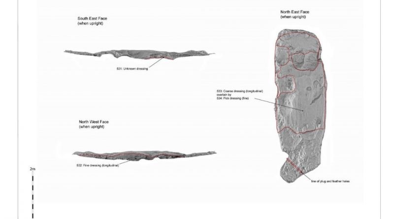
The slaughter stone has always been associated with mythology and speculation. Some say it was where Druids sacrificed bodies to their gods (hence the name); others suggested that it is merely a fallen Sarsen stone that once stood upright as the entrance to the monument. But recent scanning has shown that it was once sculpted to look ’lumpy and ‘rolling’,’ but why?
The Solution
In the centre of the Sarsen circle lays an extraordinary stone – the Altar stone; the reason it’s unique is two-fold. Firstly, it’s made of a material called mica, unlike the other Sarsen standing stones. ‘Hawkins notes that while all the other stones were either bluestone or Sarsen, the so-called altar-stone is ‘of fine-grained pale green sandstone, containing so many flakes of mica that its surface, wherever, wherever it is freshly exposed, shows the typical mica glitter’. The second reason is that it was positioned to be ‘flat’ to the landscape; the only other stone that was designed in that fashion is the Slaughter Stone.
Most archaeologists believe that the Slaughter Stone was once a standing stone at the monument’s entrance; this is a flawed theory resulting from a hypothetical drawing by Inigo Jones in 1655. This drawing shows Stonehenge as a perfect circle (Roman Solar Temple) with a hexagon-shaped trilithon and three entrances into the site with six upright standing stones as access points, of which the slaughter stone was one. This idea was incorporated in John Aubrey’s drawing in 1666, which was more accurate, but again tended to place all the fallen stones in upright positions.
This false assumption was further compounded by William Cunning in 1880 when (it was reported) that he suggested his grandfather “saw” the upright slaughter stone in the 17th Century). This mistake was later corrected, yet the myths among archaeologists remain (Stones of Slaughter, E Herbert Stone, 1924, pp120).
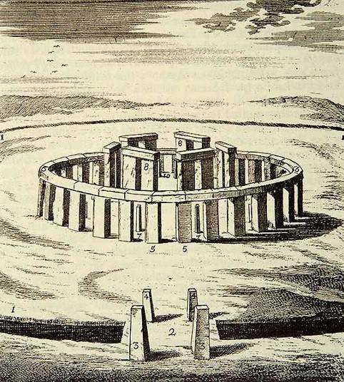
The reality is that the slaughter stone was always (like the Altar Stone) a deliberate recumbent, as the excavations of this stone by Hawley and Newall in the 1920s clearly show, as the chalk subsoil was also deliberately flattened before it was placed in its current position. Hawley presumed that the Slaughter Stone was once ‘buried’; this idea is understandable as the stone does lay below the ground level, but what Hawley never understood is that the reason the stone was in this position was for the same reason the ditch was built around Stonehenge, as it was made to be full of water.
This can be observed by the size of the stone hole called ‘E’ (WA1165), which lies two metres North West of the Slaughter stone but still within the ‘hollow’ that contains the stone. Most stone holes at Stonehenge are relatively shallow – less than a metre in-depth, but stone hole ‘E’ is twice as deep, over 2m. So if the Slaughter stone were placed in it (as the experts have suggested), it would only be 3m high on the surface, compared to 4.57m for the Heel Stone a few yards away.

The only other place in Stonehenge with these more massive pits is within the Ditch section surrounding the site, which is the same depth allowing access to the groundwater levels. In the past, when the Slaughter stone was placed in this ditch, like the moat, water would have surrounded the stone like an island.
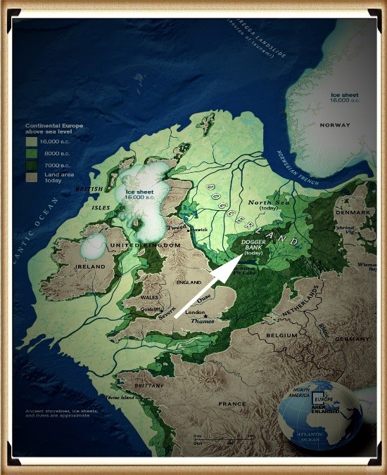
Therefore, what we see today at Stonehenge is a 6,000 year-old relief map of the land the megalithic builders originated from – Doggerland, which now lays below the North Sea.
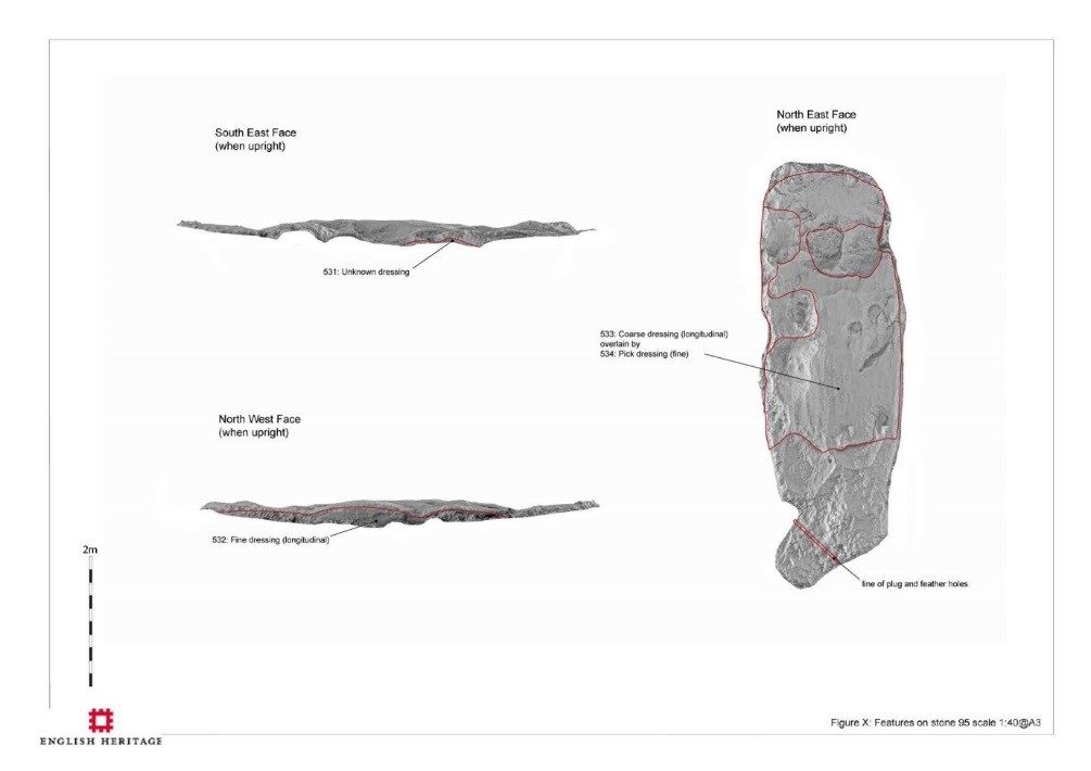
Not only did they place a 6ft piece of Sarsen stone, flat in a watery ditch, but they also carved out the island’s contours, showing high and low ground, like a contour relief map. Archaeologists have always believed these features were ‘weather-worn’ by age (although the other recumbent stones have not been weathered in the same fashion), but recent laser technology has confirmed our belief that this stone was carved, as the markings from the tools used, can still be seen at microscopic levels.
Moreover, and more importantly, the stone has been placed in a bizarre position, almost in the way of The Avenue. This shows that this stone and the Avenue have a connection, this type of relationship we see in association with Egyptian Pyramids when ‘sight lines’ are cut into the sides of the burial chambers to important star constellations to show their associations with the Gods.
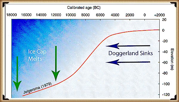
At Stonehenge, the Slaughter Stone and the Avenue are important as they link death with rebirth for this Megalithic Civilisation, for if we look from the Altar stone and follow a line past the Slaughter stone, they make a sight-line, which quite remarkably points directly to their homeland Doggerland. This was only a small island at the time of the Avenues construction in 4100 BCE but was constantly shrinking as the sea levels were (as now) continually rising. Geologists currently estimate the sinking of Doggerland as two thousand years earlier at 6200 BCE, as they have found a Tsunami that would have hit the island at that point in history.
Moreover, as we have seen in the Indian ocean and Japan – when tsunami’s hit, they do NOT sink the region, sadly, this is just another example of ‘bad science’ within archaeology. We can confirm that Doggerland did not disappear at this stage of history with a bit of simple maths. We know that the island is between 15m – 36m (average 25m) (Wikipedia) under the sea as a sandbank (and hence covered in modern-day wind farms). And we know (from satellites) that the sea rises 3.6mm per annum – consequently, by 4100 BCE it was still 6m above sea level, but probably so small it was uninhabitable.
For more information about British Prehistory and other articles/books, go to our BLOG WEBSITE for daily updates or our VIDEO CHANNEL for interactive media and documentaries. The TRILOGY of books that ‘changed history’ can be found with chapter extracts at DAWN OF THE LOST CIVILISATION, THE STONEHENGE ENIGMA and THE POST-GLACIAL FLOODING HYPOTHESIS. Other associated books are also available such as 13 THINGS THAT DON’T MAKE SENSE IN HISTORY and other ‘short’ budget priced books can be found on our AUTHOR SITE or on our PRESS RELEASE PAGE. For active discussion on the findings of the TRILOGY and recent LiDAR investigations that is published on our WEBSITE you can join our FACEBOOK GROUP.

