The Ackling Dyke Smoking Gun
Has the evidence for Britain’s prehistoric water-filled dykes been hiding in plain sight?
For more than a century, archaeologists have described Ackling Dyke as a Roman road. But at Vernditch Chase, the ancient earthworks themselves tell a very different story.
And perhaps we should begin with something rather obvious.
It is called Ackling DYKE.
The clue, one might suggest to archaeologists, was in the name all along! 😂
Of course, a place-name is not an archaeological construction date. But when a monument consists of enormous banks and excavated ditches, surely the first scientific question should be whether we are looking at a dyke rather than automatically assuming it was built as a Roman highway.
Our continuing LiDAR investigation has now identified something far more important than a resemblance between ancient earthworks.
At Vernditch Chase, a recognised prehistoric ditch system makes a remarkable change of direction, approaches Ackling Dyke, and continues across the corridor occupied by the supposed Roman road.
And this time, the prehistoric connection is not simply our interpretation.
Historic England’s own Scheduled Monument records acknowledge it.
The significance extends far beyond one Roman-road attribution. It raises a fundamental question about the accepted function of Britain’s prehistoric dykes.
Were these enormous excavations simply territorial boundaries?
Or have archaeologists repeatedly mistaken a much older system of water-filled channels for dry ditches whose only purpose was to divide the landscape?
Our investigation suggests that the engineering itself may finally provide the answer.
1. The Prehistoric Dyke That Archaeologists Already Recognise
Let us begin with the official archaeological evidence.
Historic England’s Scheduled Monument 1010763, Two Linear Earthworks in Vernditch Chase, identifies a substantial prehistoric system associated with Grim’s Ditch [1].
The principal surviving earthwork extends approximately 1.91 kilometres through the landscape.
This is not an ordinary field boundary.
At one location, the entire feature reaches approximately 18 metres across, with a ditch measuring eight to nine metres wide.
Its banks rise substantially above the ditch bottom.
The monument also incorporates two right-angled changes of direction, including a section running approximately 430 metres from north to south.
Already, the proportions are impressive.
But the most revealing feature is a second, shorter ditch.
From the southern corner of Grim’s Ditch, an additional excavated earthwork runs approximately 225 metres towards Ackling Dyke.
Its ditch is approximately five metres wide, with low banks alongside it.
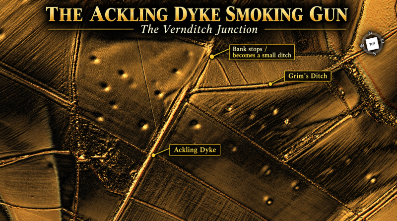
This is the feature our LiDAR investigation highlighted.
Instead of simply continuing along the main alignment, the prehistoric system changes direction and sends another substantial ditch towards the feature conventionally classified as a Roman road.
Why?
For a terrestrial boundary, this additional engineering requires an explanation.
For a connected water-channel system, it has a potentially straightforward purpose.
But before considering that explanation, we should examine more archaeological evidence.
[PICTURE SUGGESTION — FIGURE 1]
Original 1-metre LiDAR showing Grim’s Ditch, its pronounced change of direction, the 225-metre connecting earthwork and Ackling Dyke.
Caption: Figure 1. The prehistoric dyke network at Vernditch Chase. Historic England records the substantial Grim’s Ditch system and an additional 225-metre earthwork running from its southern corner towards the accepted Roman-road alignment. The arrangement presents a significant engineering question [1,5].
2. The Smoking Gun — The Dyke Continues Across the Roman Road
Here is where the conventional interpretation becomes particularly interesting.
Historic England does not merely describe a prehistoric ditch ending somewhere near Ackling Dyke.
It states that the earthwork is disturbed immediately north of the Roman-road corridor but continues on its southern side under a separate Scheduled Monument classification [1].
The corresponding southern monument, 1011006, covers three adjoining linear earthworks and Bronze Age barrows on Martin Down [2].
One of those earthworks runs approximately 1.81 kilometres from the southern system towards the recognised Roman-road alignment.
Its continuation north of the road joins Grim’s Ditch in Vernditch Chase.
Consider what this means.
On one side of Ackling, archaeologists recognise prehistoric linear earthworks.
On the other side, archaeologists recognise their continuation.
Between them lies the feature labelled Roman road.
The archaeological records therefore already establish that this is not simply a prehistoric dyke which happens to lie somewhere nearby.
The same prehistoric earthwork system extends across the corridor occupied by Ackling Dyke.
The surviving ditch is disturbed at the road, so the records do not by themselves demonstrate an uninterrupted open channel beneath the roadway. But they establish the continuation of the engineered alignment.
And this is a fundamental distinction.
The official scheduling divides the monuments into separate categories.
One is described as a prehistoric linear boundary.
The other is classified as a Roman road.
Yet the actual landscape contains ancient earthworks whose physical relationships demand investigation as a connected engineering system.
An administrative division between scheduled monuments does not explain how the structures were originally built or used.
It merely separates them on paper.
As our earlier Ackling investigation showed, separating ancient structures on paper is precisely how the original relationship between a road and a much larger dyke can become obscured.
3. Bronze Age — Not a Saxon Invention
The dating evidence becomes even more revealing.
Historic England explicitly classifies the Vernditch earthworks as Bronze Age constructions.
Its scheduling explanation recognises that substantial linear earthworks were being built from the Middle Bronze Age onwards, although they were frequently modified and reused during later periods [1].
The Martin Down record provides an additional archaeological connection with that period.
It records that Middle Bronze Age pottery was recovered from a stretch of the linear ditch excavated by General Pitt-Rivers [2].
The precise stratigraphic relationship of that pottery matters for dating construction, but its presence shows Bronze Age activity within this earthwork system.
Now consider the wider historical problem.
Large British dykes are often discussed through the familiar example of Anglo-Saxon territorial works such as Offa’s Dyke.
Offa’s Dyke does have an early medieval history. But it is a mistake to extend that date or explanation to every substantial bank-and-ditch system in Britain.
At Vernditch Chase, Historic England itself recognises prehistoric origins.
And nearby Bokerley Dyke provides another striking example.
Historic England’s Scheduled Monument 1012135 states that Bokerley Dyke is believed to have originated during the Bronze Age or Early Iron Age, despite extensive later remodelling [3].
Therefore, an exclusively Saxon construction explanation cannot account for these earlier phases.
The prehistoric builders were excavating enormous dykes long before the Anglo-Saxon kingdoms existed.
That is not our invention.
It is the chronology recognised by the archaeological authorities themselves.
But while the dating evidence is important, it raises another issue.
Having recognised prehistoric construction, archaeologists generally interpret these enormous linear earthworks as territorial boundaries.
And this is where our investigation challenges the conventional explanation.
A prehistoric date does not automatically demonstrate a territorial function.
The two are entirely different archaeological questions.
4. The Boundary Explanation — But Where Is the Engineering Logic?
Historic England’s records interpret many substantial prehistoric linear earthworks as boundaries marking the territories of ancient communities [1,2].
That interpretation has become so familiar that it is often repeated as though the monument’s function were self-evident.
But what exactly demonstrates that a substantial excavated ditch was built simply to mark territory?
A boundary requires recognition.
It might consist of a bank, fence, stones, posts or a natural landscape feature.
A substantial ditch could reinforce such a boundary, particularly where defence or the control of movement was important.
But when an earthwork repeatedly changes direction and sends additional excavated branches towards another major ditch system, we must examine whether it performed a more practical engineering function.
This is precisely the problem at Vernditch Chase.
The prehistoric ditch does not simply follow one uninterrupted line.
It changes direction.
It forms pronounced corners.
And from one of those corners, another substantial ditch runs towards Ackling.
If this arrangement represented nothing more than a territorial division, the extra connecting earthwork still requires explanation.
Why excavate hundreds of metres of additional ditch to reach another enormous linear feature?
Why is physical connection apparently important?
The conventional boundary interpretation describes what the feature may have symbolised.
Our investigation asks what its engineering was designed to accomplish.
And that is where water becomes central.
5. Water Explains the Peculiar Dog-Leg
A terrestrial road and a water channel operate according to very different engineering principles.
A road requires a usable travelling surface.
Where two roads meet, traffic can turn from one onto the other.
The road surfaces do not require deep excavated trenches connecting them.
Water behaves differently.
If one excavated channel was intended to feed another, the connection becomes essential.
The ditch floors, gradients and water levels determine whether water can move between the two structures.
Suddenly, the unusual dog-leg at Vernditch Chase becomes much more intelligible.
Under our hydraulic interpretation, the prehistoric builders were not excavating an unnecessarily complicated territorial line.
They were creating a connection between two substantial excavated channels.
The ditch turns because it needs to reach the adjoining system.
This also explains why the banks and excavations are so much larger than the structures required for an ordinary trackway.
Under this model, the ditch is not merely the source of material for raising a bank.
It is the important engineered feature in its own right.
It may have carried water, controlled its movement, provided access to former waterways or supported transport and extraction activities within the surrounding landscape.
The banks would then be a consequence of constructing that channel, rather than necessarily its principal purpose.
Our original investigation proposed exactly this relationship.
And at Vernditch Chase, the prehistoric continuation recorded by Historic England gives that proposal a physical basis.
The critical question is no longer simply why the dyke has a ditch. It is why the prehistoric ditch network is arranged to reach another major linear earthwork.
[PICTURE SUGGESTION — FIGURE 2]
Annotated LiDAR of the dog-leg with the two prehistoric scheduled monuments identified. Show the recorded continuation across the Ackling corridor. Overlay the proposed hydraulic connection using a different line style from observed earthworks.
Caption: Figure 2. The Vernditch junction. The prehistoric earthwork makes a pronounced change of direction towards the Ackling Dyke corridor. Under the hydraulic interpretation, the dog-leg may represent a purposeful connection between excavated channels rather than an otherwise unexplained diversion in a territorial boundary [1,2,5].
6. And the Supposed Roman Road Has an Enormous Ditch of Its Own
Now examine Historic England’s description of Ackling Dyke itself.
Scheduled Monument 1008707 records approximately two kilometres of the supposed Roman road along the southern edge of Vernditch Chase [4].
Genuine evidence exists for constructed road surfaces.
Historic England records gravel metalling, flint foundations and a raised agger varying from approximately five to eleven metres in width.
That is important.
Our investigation has never needed to deny that Roman engineers constructed and used roads in this landscape.
The problem is the larger earthwork.
Historic England describes roadside ditches normally measuring approximately two to three metres wide.
Yet one section has a ditch reaching approximately eight metres wide and one metre deep.
Why should the supposed drainage arrangement vary so substantially?
The larger ditch does not automatically have the same history or function as the Roman road surface beside it.
And once the neighbouring prehistoric dyke system is considered, we have a very different explanation worth examining.
The Romans could have built or resurfaced a wheeled road alongside an older major earthwork.
The road could have incorporated existing banks.
Earlier ditches might have continued to influence the course of the later route.
And later alterations could have obscured the original arrangement.
This would explain why the recognised Roman road can contain genuine metalling while the surrounding earthworks display dimensions and relationships associated with the much larger prehistoric dyke landscape.
Finding a Roman road surface does not date the excavation of every enormous ditch running beside it.
That error lies at the centre of our Ackling investigation.
7. Pitt-Rivers Had Already Found the Importance of Water
Our interpretation is not based solely on LiDAR.
At Woodyates and Bokerley Junction, General Pitt-Rivers excavated genuine road construction and a complicated network of substantial drains and ditches.
He recorded features including the Fore Drain, Boundary Drain, Mid Drain and Cross Drain [5,6].
More importantly, he measured their relationships.
In one particularly revealing section, Pitt-Rivers established that the bottom of the Cross Drain was approximately 6.6 feet higher than the bottom of the Fore Dyke ditch.
He considered what that difference meant for drainage and construction sequence.
That is a remarkable piece of nineteenth-century archaeological engineering analysis.
Pitt-Rivers understood that the relative elevations of these excavations mattered.
In effect, he was testing their ability to convey water.
Our investigation takes the same engineering principle and applies it to the wider LiDAR landscape.
At Woodyates, multiple substantial dykes converge near the Ackling corridor.
At Vernditch Chase, Grim’s Ditch sends another excavated feature towards it.
Elsewhere, major earthworks approach palaeochannels and areas containing concentrations of extraction pits.
The recurring pattern suggests a landscape structured around more than simple terrestrial movement or symbolic territorial division.
The possibility of a connected water-management or transport network deserves serious attention.
And if earlier water levels differed substantially from those of the present landscape, as proposed in the Post-Glacial Flooding Hypothesis, some excavated ditches might once have operated as water-filled channels even where they now appear entirely dry [7].
A dry ditch today is not proof that the ditch was always dry.
8. What Would a Water-Filled Prehistoric Network Explain?
The water-channel interpretation has a major advantage.
It offers a single functional explanation for several otherwise puzzling features.
It explains why substantial ditches make apparently awkward connections.
It explains why some earthworks run towards former waterways.
It explains why major banks sometimes accompany enormous single ditches rather than conventional paired roadside drains.
It also provides a possible reason for the repeated association between substantial earthworks and prehistoric extraction landscapes.
If people removed materials from chalk downs and adjoining resource areas, a connected system of water channels could have helped move heavy loads to accessible waterways.
As conditions changed, those channels might have been abandoned, shortened, extended or reused for terrestrial movement.
Later communities, including the Romans, could have incorporated the existing earthworks into their own communications network.
This reconstruction emerges from our wider investigation of Ackling Dyke.
But we should be precise about what the smoking gun establishes.
Historic England documents the prehistoric earthwork continuing across the Roman-road corridor. Our LiDAR reveals the dog-leg’s geometry. Together they challenge the assumption that the entire engineered landscape can be explained as Roman road construction or disconnected territorial boundaries.
Demonstrating that the connecting ditch actually carried water at a particular prehistoric date requires the ditch-bottom levels, sediment evidence and contemporary hydrological conditions to agree.
Those measurements determine whether the proposed water system could function.
That is not a concession to the Roman-road interpretation. It is how an engineering hypothesis becomes a demonstrable reconstruction.
The conventional interpretation should be held to exactly the same standard.
9. The Mistake Was Calling Everything a Road — or a Boundary
This investigation exposes a broader methodological problem.
When archaeologists encounter a substantial earthwork, the interpretation often begins with its accepted historical classification.
A feature aligned with a Roman route becomes a Roman road.
A substantial prehistoric bank and ditch becomes a territorial boundary.
A large early medieval earthwork becomes a defensive frontier.
Yet none of those labels, by itself, establishes the original function of every excavated structure.
At Vernditch Chase, those classifications meet in the same landscape.
The Bronze Age earthworks are documented.
Their continuation across the Roman-road corridor is recorded.
A genuine Roman-style road formation survives nearby.
LiDAR also indicates a prehistoric ditch alignment whose unusual geometry is consistent with a purposeful connection to the larger system.
We therefore have a far more complicated construction history than the familiar description of one Roman road passing through a landscape of separate territorial dykes.
The question is not simply who last used these earthworks. It is who first excavated them, and why.
A prehistoric dyke could have acquired a later boundary function.
Roman engineers could equally have constructed a road alongside or on an existing earthwork.
Neither later use establishes the original purpose.
And if the original purpose was hydraulic, the surviving landscape would preserve precisely the sort of relationships our LiDAR investigation is now revealing.
10. The Ackling Dyke Smoking Gun
We can now bring the evidence together.
Historic England recognises substantial prehistoric dykes at Vernditch Chase.
It records a connecting earthwork running towards Ackling Dyke and continuing across the corridor.
The Martin Down record identifies Middle Bronze Age pottery recovered during excavation of the prehistoric linear system.
Nearby Bokerley Dyke is itself believed to have originated in the Bronze Age or Early Iron Age, long before its later modifications.
The supposedly Roman Ackling corridor contains genuine road construction, but also larger ditches whose dimensions and construction relationships are not explained merely by the presence of Roman metalling.
Our LiDAR identifies a remarkable dog-leg in the prehistoric ditch system.
And our earlier investigation of Pitt-Rivers’ work shows that water movement and ditch-bottom elevations were important to the engineering of this wider landscape.
This is the smoking gun against treating Ackling Dyke as nothing more than one continuously constructed Roman road.
The evidence for prehistoric earthworks is not disputed.
The physical continuation is recorded.
What remains at issue is how the ancient system functioned.
We interpret the large excavated dykes as part of a much older, potentially water-filled infrastructure network, with Roman roads later using parts of that engineered landscape.
That model explains why a ditch would turn to meet another ditch.
It explains why enormous earthworks can accompany much smaller road formations.
And it explains why the same corridor can preserve both prehistoric engineering and genuine Roman construction.
The familiar interpretation says these prehistoric earthworks divided territories.
Our investigation asks whether they also connected people, resources and waterways.
Because sometimes the greatest archaeological mistake is not failing to find a monument.
It is finding the monument, giving it the wrong function, and then repeating that explanation for the next hundred years.
And in the case of Ackling Dyke, perhaps the name should have prompted the question a little earlier.
After all, they did call it a dyke. 😎
References
[1] Historic England. Two Linear Earthworks in Vernditch Chase. Scheduled Monument 1010763.
https://historicengland.org.uk/listing/the-list/list-entry/1010763
[2] Historic England. Three Adjoining Linear Earthworks and Three Bowl Barrows North of Bokerley Dyke on Martin Down. Scheduled Monument 1011006.
https://historicengland.org.uk/listing/the-list/list-entry/1011006
[3] Historic England. Bokerley Dyke, a Section of Grim’s Ditch, a Medieval Boundary Bank and Two Bowl Barrows. Scheduled Monument 1012135.
https://historicengland.org.uk/listing/the-list/list-entry/1012135
[4] Historic England. Roman Road Along the South Side of Vernditch Chase. Scheduled Monument 1008707.
https://historicengland.org.uk/listing/the-list/list-entry/1008707
[5] Langdon, R. J. (2026). Ackling Dyke — Part III: The Roman Road Mystery Finally Makes Sense. Prehistoric Britain.
https://prehistoric-britain.co.uk/ackling-dyke-roman-road-mystery-finally-makes-sense
[6] Pitt-Rivers, A. H. L. F. (1892). Excavations in Cranborne Chase, Near Rushmore, on the Borders of Dorset and Wilts. Volume III.
[7] Langdon, R. J. (2026). The Post-Glacial Flooding Hypothesis: The Evidence. Version 3.4.
Related reading: Ackling Dyke — Facts and the Archaeological Fiction — our original LiDAR investigation into the construction and morphology of the recognised Roman-road corridor.