The Stonehenge Enigma: Part 1/6
The Archaeological Evidence – Book Extract
The Post-Glacial Flooding Hypothesis
Chapter 4
What the Early Excavations Found
Long before modern geological surveys were conducted, archaeologists had already begun investigating the interior of the Stonehenge enclosure. Between 1919 and 1926 Lieutenant-Colonel William Hawley carried out the first systematic excavations of the monument. His work was followed by later investigations, most notably those directed by Richard Atkinson during the mid-twentieth century. (The Stonehenge Enigma; The Archaeological Evidence)
These excavations were primarily concerned with understanding the monument’s construction sequence. Trenches were opened across the ditch, around the stone settings, and within many of the features that form the complex layout of Stonehenge. The discoveries made during these investigations established much of the archaeological framework that is still used to interpret the monument today.
However, the excavation reports also contain numerous observations on the soil, sediments, and fills encountered during excavation. At the time, these descriptions were simply recorded as part of the archaeological record. In hindsight, some of these observations provide important clues about the environmental conditions that existed at the site.
One of the most striking features uncovered during the early excavations was the nature of the ditch surrounding the monument. Rather than being cut into solid chalk alone, the ditch contained a mixture of chalk rubble, silts, and other sediments that had accumulated within it after its construction.
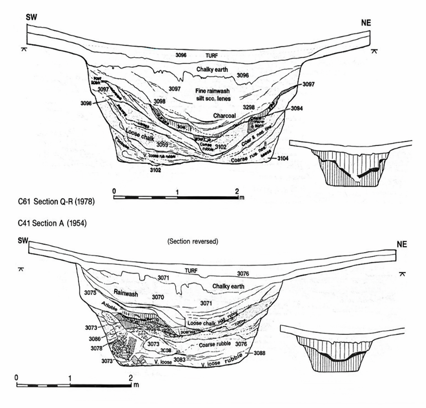
Figure 5 – Hawley’s Ditch Excavations and the ‘Dark Layer’
In places, the lower fills of the ditch were described as soft chalk slurry and silty deposits, suggesting that water had been present within the feature at various times. Such conditions can occur when rainwater or groundwater collects within excavated hollows, gradually depositing fine sediments as the water settles.
Similar observations were made in other features within the monument. Some excavated pits and holes contained deposits of fine silt and mixed sediments, rather than the simple collapse of chalk rubble that might be expected in a completely dry environment.
These details attracted relatively little attention at the time because the primary goal of the excavations was to establish the chronology of the monument rather than reconstruct its environmental setting. Nevertheless, the descriptions recorded in the excavation reports remain valuable pieces of evidence.
When viewed alongside the geological evidence discussed in the previous chapter, these archaeological observations begin to take on a new significance. Features that were once interpreted simply as construction cuts or refuse deposits may also reflect the interaction between the monument and the surrounding hydrological environment.
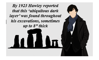
In other words, the excavations did not merely reveal the architecture of Stonehenge; they also recorded traces of the landscape conditions in which the monument once stood.
The importance of this relationship between archaeology and environment becomes clearer when the wider Stonehenge landscape is considered. The monument was not an isolated structure but part of a much larger complex of earthworks, avenues, and associated sites that extend across the surrounding countryside.
Understanding how these features relate to one another requires us to look beyond the excavation trenches and examine the broader landscape in which Stonehenge was built.
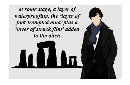
For full information see our blog: https://prehistoric-britain.co.uk/the-great-stonehenge-hoax
Chapter 5
The Earthwork Enclosure
The earliest structural feature at Stonehenge is the circular earthwork enclosure that surrounds the monument. This enclosure consists of a ditch approximately 100 metres in diameter, with an internal bank formed from the chalk removed during its excavation.
The first systematic investigation of this feature was carried out by Lieutenant-Colonel William Hawley between 1919 and 1926. Hawley opened several trenches across the ditch and bank in order to understand how the monument had been constructed. His excavations confirmed that the ditch had been cut directly into the natural chalk bedrock that underlies Salisbury Plain.
Hawley recorded the ditch as being roughly 6–7 metres wide and up to 2 metres deep, with a steep inner face and a more gradual outer slope. The chalk removed from the ditch had been thrown inward to form the surrounding bank, creating the circular boundary that still defines the monument today.
Later excavations and reassessments of Hawley’s work confirmed that this enclosure represents the earliest construction phase of the monument. The circular earthwork established the basic layout of the site, around which later features—including the stone settings—were arranged.
While the purpose of the ditch and bank has often been interpreted simply as a boundary marker, the excavation reports contain several observations about the ditch fills that deserve closer examination.
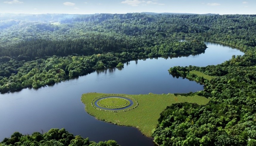
| Figure 6 – Phase 1 started with a ditch and bank |
Physical Characteristics of the Ditch
Hawley observed that the lowest fills of the ditch consisted largely of collapsed chalk rubble that had fallen from the sides of the excavation over time. Above this material were layers of fine silts and mixed sediments that had gradually accumulated within the hollow.
In certain sections of the ditch, Hawley also recorded the presence of a dark organic layer lying above the lower chalk deposits. Such layers can develop when water remains within a feature long enough for organic material and fine sediments to settle and accumulate.
Another observation made during the excavations was the presence of clay deposits within parts of the ditch base. Clay is not a common material in the surrounding chalk downland, and its occurrence in the ditch suggests it may have been deliberately introduced.
Perhaps the most unusual feature described in the excavation reports was the occurrence of densely packed flints within sections of the ditch floor. These flints appeared to have been compacted into the underlying sediments, suggesting that they had been trodden or pressed into place rather than simply deposited as loose rubble.
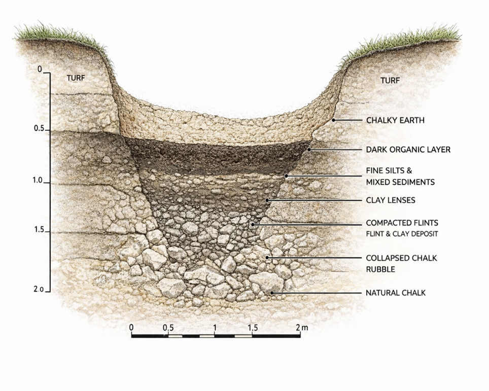
Taken individually, these observations might appear unremarkable. However, when considered together, they suggest that the ditch experienced conditions quite different from those expected in a permanently dry chalk environment.
When the ditch observations are viewed in light of the geological setting described in the previous chapters, a more complex picture begins to emerge.
The Stonehenge enclosure lies within a shallow basin in the chalk plateau of Salisbury Plain. In chalk landscapes, groundwater levels can fluctuate significantly depending on climatic conditions. When groundwater rises, or prolonged rainfall occurs, water may collect in depressions and excavated features before draining away towards nearby river valleys.
Under such circumstances, a ditch cut into chalk bedrock could temporarily hold water. Standing or slow-moving water would allow fine silts and organic material to settle, producing the types of deposits described in the excavation reports.
The combination of clay deposits and compacted flints recorded in parts of the ditch is also noteworthy. A similar construction method has long been used to form traditional dew ponds on chalk downlands. In such ponds, a layer of clay is used to seal the basin, while chalk rubble or flints are pressed into the surface to stabilise the lining and prevent erosion.
The resemblance between these construction techniques and the features recorded in the Stonehenge ditch does not necessarily mean that the enclosure was intended to function as a dew pond. However, the similarities suggest that the builders may have been aware of how clay and compacted stone could be used to control or retain water within excavated features.
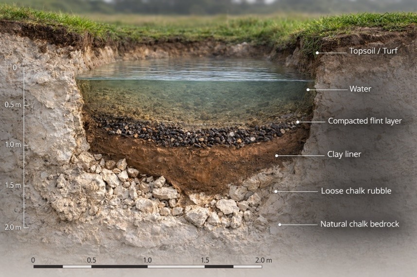
Whether the ditch occasionally held water as a result of natural hydrological conditions, or whether aspects of its construction were intended to influence how water behaved within the enclosure, remains an open question. What is clear from the excavation record is that the ditch did not remain a simple dry hollow throughout its history.
These observations provide an important reminder that the archaeological features at Stonehenge cannot be fully understood without considering the environmental conditions of the surrounding landscape
Closer examination of the excavation reports also reveals an important structural detail about the enclosure ditch that is often overlooked. Although the monument is usually described simply as a continuous circular ditch, Hawley’s excavation trenches showed that the feature was not cut as a uniform trench in the manner of a conventional defensive earthwork.
Instead, sections of the ditch appear to have been excavated as a series of adjoining pits or scoops, separated by short chalk walls or uncut partitions. In some places, the sides of these pits formed distinct vertical faces, while the bases contained flattened areas resembling seating ledges or working platforms within the chalk.
This segmented construction is unusual when compared with later defensive or boundary ditches, which are normally dug as continuous trenches designed to maximise obstruction or drainage. The Stonehenge enclosure, by contrast, appears to have been created through a sequence of individual excavation pits that collectively form the circular earthwork seen today.
Such a design raises important questions about how the feature functioned. A series of adjacent pits would behave very differently from a continuous drainage ditch. Individual hollows within the ring could potentially retain water independently, particularly if parts of the base were lined or compacted as suggested by the clay deposits and trodden flints described earlier.
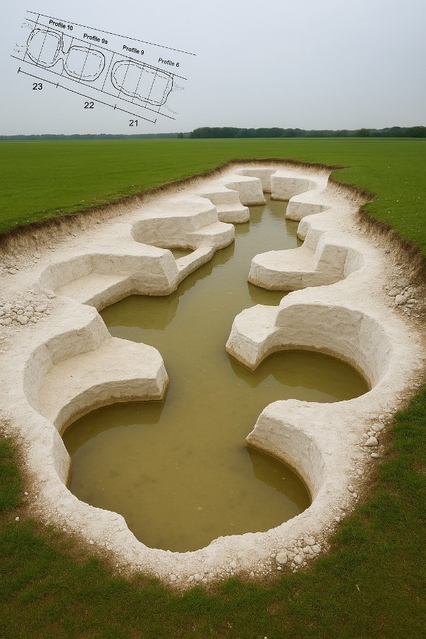
| Figure 7- The UNIQUE ditch showing Pits , Walls and Seats |
In this sense, the enclosure may have functioned less like a defensive ditch and more like a chain of shallow basins arranged around the perimeter of the monument. Whether these basins were intentionally designed to interact with water, or whether this behaviour emerged from the way the ditch was excavated into the chalk, remains an important question when considering the environmental setting of Stonehenge.
These observations provide an important reminder that the archaeological features at Stonehenge cannot be fully understood without considering the environmental conditions of the surrounding landscape.
This brings us to one of the most intriguing elements of the monument’s earliest phase: a ring of pits discovered just inside the enclosure ditch. Known today as the Aubrey Holes, these features are among the most distinctive and debated components of the Stonehenge layout.
For full information see our blog: https://prehistoric-britain.co.uk/stonehenge-phase-1-britains-first-monument
Chapter 6
The Aubrey Holes – The Operating Ring of the Stonehenge Computer
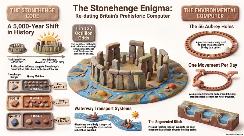
Just inside the enclosure ditch lies a ring of 56 evenly spaced pits, known as the Aubrey Holes. These features are among the earliest structural elements of the monument and define a circle approximately 87 metres in diameter.
The pits were first recognised in the seventeenth century by the antiquarian John Aubrey, but their archaeological significance was confirmed during the excavations of William Hawley in the 1920s. Hawley demonstrated that the features were deliberately excavated pits cut into the chalk bedrock, each roughly 1 metre in diameter and about 1 metre deep.
The precision of their layout is striking. Fifty-six pits are spaced almost perfectly around the interior of the enclosure, producing a regular circular array that would have required careful measurement during construction. The labour required to excavate such a ring into solid chalk also indicates that the feature served a deliberate and specific purpose.
Despite more than a century of study, conventional archaeological interpretations have never provided a convincing explanation for why exactly 56 pits were constructed in this precise circular arrangement.
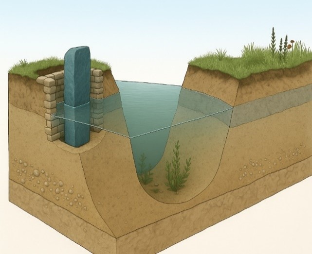
Figure 8 – Bluestone in an Aubrey Hole and the Ditch Relationship
The Mathematical Structure of the Circle
The number 56 is unlikely to be accidental.
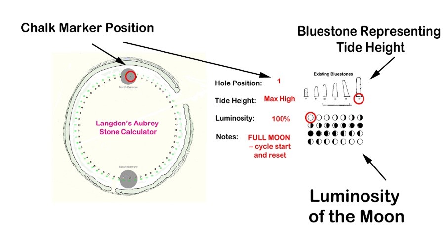
A circle divided into fifty-six positions creates a simple numerical system capable of tracking repeating natural cycles. When used sequentially, the ring allows a marker to move around the circle one position at a time, returning to the starting point after completing the cycle.
The significance of this number becomes clear when compared with the behaviour of tidal and lunar cycles. The circle of 56 positions can represent two consecutive 28-day tidal cycles, allowing the system to track the repeating pattern of tidal strength associated with the Moon.
By advancing a marker one position each day, the circle becomes a continuous counting mechanism. After two 28-day cycles, the marker returns to its starting point and the sequence begins again.
Such a system requires only a simple rule: one movement per day.
The One-Marker Operating System
The Aubrey circle can therefore be operated using a single movable marker.
In this arrangement:
• each Aubrey hole represents one day
• the marker advances one position per day
• the full circle records two tidal cycles
• the sequence then repeats indefinitely
This creates a simple analogue system for tracking the strength of tidal cycles through time.
For societies dependent on water transport, such information would have been highly valuable. Predicting when strong or weak tides would occur allows travellers to plan journeys through shallow waterways, estuaries, and flooded river systems where water levels and currents change dramatically during the lunar cycle.
The Aubrey ring therefore functions not merely as a geometric feature but as a circular counting mechanism capable of encoding natural environmental cycles.
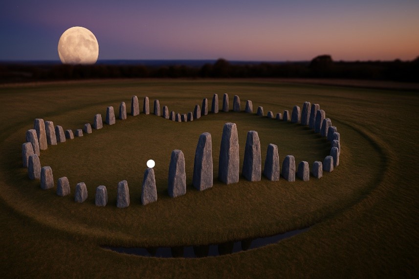
Stonehenge as an Environmental Computer
When the Aubrey ring is considered within the wider landscape context described earlier in this book, its significance becomes clearer.
If prehistoric Britain possessed higher groundwater levels, expanded river systems, and extensive wetlands—as suggested by geological and borehole evidence—then movement through the landscape would often have depended on water. Travel along rivers, flooded valleys, and coastal inlets would have required knowledge of changing water levels and tidal behaviour.
In such an environment, the ability to predict tidal strength and water movement would have been a practical necessity. The Aubrey circle offers a simple yet effective mechanism for tracking these cycles over time.
Seen in this light, the monument can be interpreted not simply as ceremonial architecture but as an environmental computing device—a fixed geometric structure used to measure and predict the rhythms of the natural world.
A more detailed analysis of this operating system, including the role of the bluestones and the North and South Barrows that are within the ditch ring which helps indicating tidal strength and the full mechanics of the Stonehenge tidal model, is presented in the companion study Stonehenge: The World’s First Computer, where the system is examined in depth.

The earliest phase of Stonehenge therefore combines two key elements:
• the segmented enclosure ditch
• the 56-hole Aubrey ring
Both were excavated directly into the chalk bedrock and form part of the monument’s ground architecture.
Together they suggest that the earliest builders of Stonehenge were not simply creating a symbolic enclosure but constructing a carefully designed geometric system embedded within the landscape.
In this interpretation, the monument began as a functional instrument, capable of tracking environmental cycles that influenced movement and activity within the surrounding landscape.
Understanding how this early system developed further requires examining the next phase in the monument’s construction: the erection and arrangement of the stone settings that transformed Stonehenge into one of the most recognisable structures of prehistoric Britain.
For full information see our blog: https://prehistoric-britain.co.uk/stonehenge-the-worlds-first-computer
Chapter 7
The Bluestones – Craig Rhos-y-Felin and the Welsh Quarries
Identifying the Source of the Bluestones
The smaller stones within the Stonehenge monument are known as bluestones, typically weighing between two and four tonnes. Unlike the larger sarsen stones that dominate the later monument, the bluestones are composed of several distinct volcanic and igneous rock types not found on Salisbury Plain.
Recent advances in geochemical fingerprinting have allowed archaeologists to match these stones to specific outcrops in the Preseli Hills of western Wales. Among the most significant of these locations is the quarry site at Craig Rhos-y-Felin, along with additional sources such as Carn Goedog and other nearby Preseli outcrops.
These discoveries have confirmed that the bluestones used at Stonehenge originated more than 200 kilometres away from the monument.
Identifying the quarry sources, however, raises a far more important question: when were these stones quarried and transported?
Excavations at Craig Rhos-y-Felin and Carn Goedog have revealed clear signs of prehistoric activity associated with the extraction of bluestones.
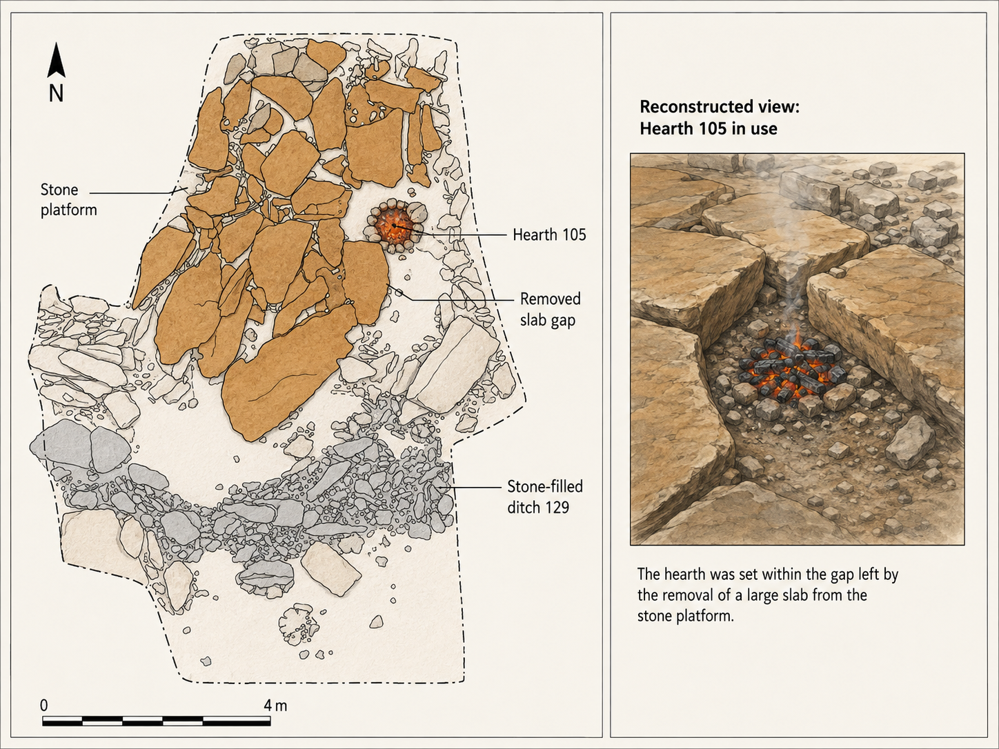
At Craig Rhos-y-Felin archaeologists discovered human-made hearths, stone tools, and a partially quarried monolith still embedded in the rock face. These findings demonstrate that the outcrop was not simply a natural deposit but a location where stone was deliberately worked.
Radiocarbon dating of charcoal from these hearths has produced a series of dates indicating repeated human activity at the quarry sites.
Crucially, many of these dates fall within the Mesolithic period, long before the Neolithic period traditionally associated with the construction of Stonehenge.
The presence of these hearths, together with the quarry features themselves, indicates that people were working these outcrops and interacting with the bluestone deposits thousands of years earlier than previously assumed.
The Landscape of the Quarry Sites
The geographical setting of the quarry sites provides further clues about how the stones may have been transported.
Craig Rhos-y-Felin lies beside what was once a substantial river system feeding into the River Nevern. Radiocarbon dating of the palaeochannel deposits indicates that this watercourse flowed past the quarry outcrop for thousands of years, extending to within a few metres of the rock face.
Evidence from the site suggests that during the Mesolithic period the river was significantly larger than the stream visible today.
This positioning is significant. It places the quarry directly on the edge of a navigable waterway capable of transporting heavy materials.
Similar patterns appear elsewhere in the Preseli region. Other bluestone sources, including Carn Goedog and nearby outcrops, are also connected by streams and rivers leading toward larger river systems.
The quarry sites therefore sit within a network of waterways that would have provided natural transport routes across the landscape.
Transport by River
Moving multi-tonne stones across rugged terrain presents enormous logistical challenges if attempted overland. By contrast, transporting heavy loads by water is far more efficient, as buoyancy allows boats or rafts to carry stones with relatively little effort.
The location of the bluestone quarries along river systems suggests that water transport may have been the primary means of moving these stones.
Rather than dragging stones across mountains, forests, and valleys, it would have been far easier to load them onto boats and transport them along the river systems connecting the Preseli region to the wider landscape.
This possibility becomes even more plausible when the environmental conditions of the early Holocene are considered. Higher water levels and expanded river systems would have made river navigation far more practical than it appears today.

Evidence from Stonehenge itself also points toward human activity during the Mesolithic period.
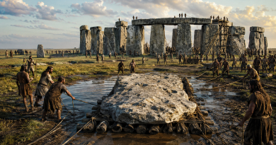
Excavations near the monument, including discoveries around the former visitor car park, revealed a series of postholes associated with the site’s early occupation. Charcoal recovered from these features produced radiocarbon dates ranging from approximately 8860 to 6590 BCE.
Additional discoveries include a piece of rhyolite associated with one of these features and charcoal recovered from stone sockets near the monument.
These findings indicate that the Stonehenge landscape was already a place of human activity thousands of years before the traditionally accepted Neolithic construction date of the monument.
6. Connecting the Quarry Sites and Stonehenge
When the radiocarbon evidence from the Welsh quarry sites is compared with the Mesolithic dates obtained from Stonehenge, an intriguing pattern emerges.
Both locations show evidence of human activity during overlapping periods of the Mesolithic era.
This overlap raises an important question: could the activity recorded at the quarry sites and the early activity recorded at Stonehenge be connected?

To answer this question, it is necessary to examine the radiocarbon datasets from both locations in detail and determine whether the similarities between them could have occurred by chance.
The Code
A detailed analysis of the radiocarbon datasets from Stonehenge and the Welsh quarry sites reveals a remarkable statistical relationship between the two.
When the calibrated radiocarbon ranges from the Stonehenge post holes are compared with those from Craig Rhos-y-Felin and Carn Goedog, the probability that the observed overlaps occurred purely by chance becomes extraordinarily small.
Using a probability model that compares the overlapping ranges of these independent radiocarbon samples, the likelihood that the pattern occurred by chance is approximately 1 in 1.27 × 10²⁹.
In practical terms, this probability is so small that it strongly suggests a genuine chronological relationship between the activity recorded at the Welsh quarry sites and the early activity at Stonehenge.
This statistical pattern forms what may be described as The Stonehenge Code.
The mathematical analysis behind this conclusion, and the implications it has for the dating of Stonehenge’s earliest phase, will be examined in detail in the following chapter.
For more detailed information see our blog: https://prehistoric-britain.co.uk/bluestone-enigma
Chapter 8
The Stonehenge Code
The accepted chronology of Stonehenge places its construction within the Neolithic period, beginning around 3000 BCE and continuing through several later phases of modification. This interpretation has remained largely unchanged for decades and forms the basis of most archaeological explanations of the monument.
However, a growing body of radiocarbon evidence challenges this timeline.
Excavations at both Stonehenge and the Welsh bluestone quarry sites have produced a series of dates that extend deep into the Mesolithic period. These dates have often been treated as isolated anomalies because they do not fit comfortably within the accepted Neolithic framework.
Yet when these dates are examined together rather than individually, a striking pattern begins to emerge.
Recent carbon dating at the bluestone quarry sites provides compelling, irrefutable mathematical evidence that Stonehenge’s construction dates to the Mesolithic era. This new data suggests Stonehenge is approximately 5000 years older than experts had previously believed, challenging established views on its origins and adding new depth to our understanding of this ancient monument
Mesolithic Evidence at Stonehenge
Evidence for Mesolithic activity at Stonehenge has been known for decades.
During excavations in 1966, Lance and Faith Vatcher discovered several post holes near Stonehenge, close to the location of the old visitor car park. These holes were initially interpreted as having a Neolithic character, although no datable pottery was found.
Later analysis revealed that charcoal from these features consisted largely of pine. This created a problem for the established chronology, as pollen evidence suggested pine had disappeared from the area before the supposed Neolithic construction of Stonehenge.
Radiocarbon dating eventually placed these pine charcoal samples firmly within the Mesolithic period, producing dates between approximately 8860 BCE and 6590 BCE.
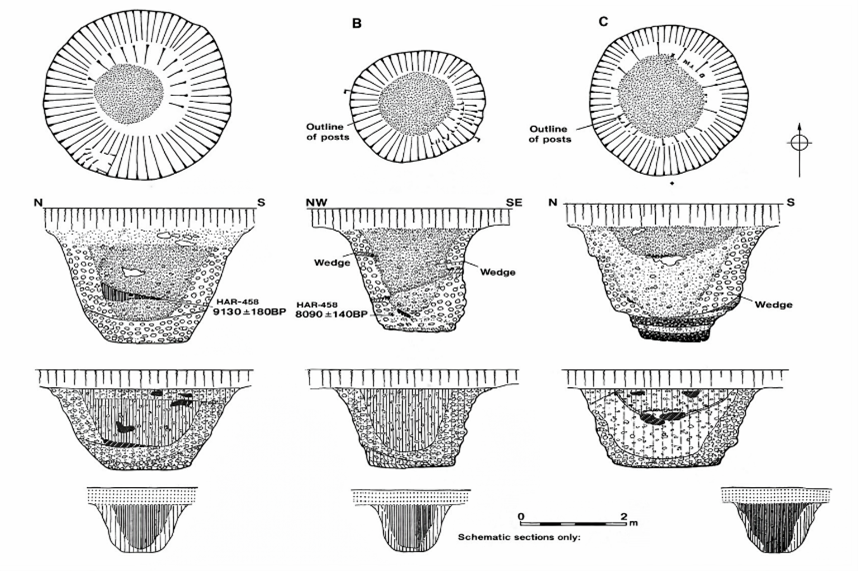
Figure 9- Old Car Park Post Holes
Rather than prompting a reassessment of Stonehenge’s chronology, these early dates were generally dismissed as evidence of unrelated Mesolithic activity, sometimes interpreted as the remains of totem poles erected by hunter-gatherer groups passing through the landscape.
Further discoveries complicated the situation.
In 1988–89, Wessex Archaeology uncovered another Mesolithic posthole, along with a piece of rhyolite dated between 7737 and 7454 BCE. Additional charcoal discovered in the socket of Stone 10 during excavations by Darvill and Wainwright produced dates between 7330 and 7060 BCE.
These findings indicate that human activity at Stonehenge began thousands of years earlier than the accepted Neolithic construction date.
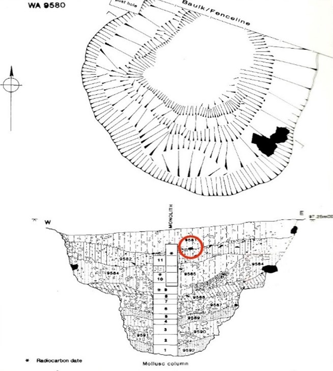
| Figure 10 – Another Old Car Park Post Hole found in 1988 |
Mesolithic Activity at the Bluestone Quarries
At the same time that early dates were appearing at Stonehenge, excavations in the Preseli Hills of Wales began identifying the sources of the monument’s bluestones.
Quarry sites at Craig Rhos-y-Felin and Carn Goedog revealed evidence of prehistoric quarrying activity, including artificial platforms, quarry debris and human-made hearths.
Radiocarbon dating of these hearths produced a series of Mesolithic dates spanning several millennia.
At Craig Rhos-y-Felin alone, hearths produced dates in three main clusters:
• 8550 – 8330 BCE
• 8220 – 7790 BCE
• 7490 – 7190 BCE
These dates indicate that human activity at the quarry spanned a long period, possibly more than a thousand years.
The layout of the quarry site is also significant. Geological evidence shows that during the Mesolithic period, a large stream that fed the River Nevern flowed directly past the rock outcrop. Charcoal from the basal fill of this palaeochannel dates between 5800–5640 BCE and 5620–5460 BCE, confirming that substantial watercourses existed beside the quarry during the period of human activity.
This geographical arrangement strongly suggests that quarried stones could have been transported directly by boat.
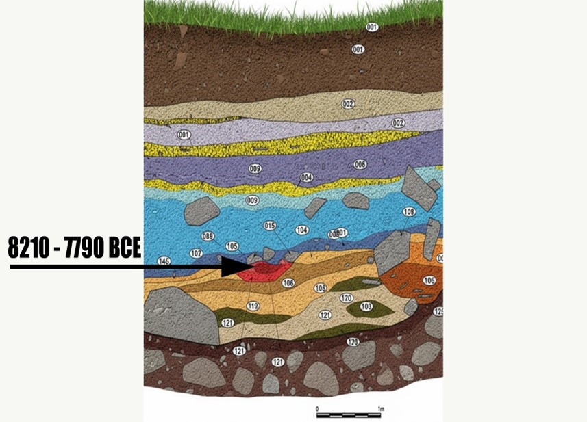
Figure 11- one of four hearths found on site – all Mesolithic in date
The Problem with Conventional Interpretation
Despite the large number of Mesolithic dates from the quarry sites, archaeological interpretation has tended to focus on a much smaller number of Neolithic samples that better match the traditional Stonehenge chronology.
For example, reports describing Craig Rhos-y-Felin highlighted two radiocarbon dates that appeared consistent with the accepted Neolithic construction phase of Stonehenge. These dates were used to support the theory that the monument may have been constructed in Wales and later dismantled and moved to Salisbury Plain several centuries later.
However, this interpretation largely overlooks the much larger dataset of Mesolithic dates from the same excavation.
The presence of multiple Mesolithic hearths at the quarry raises an obvious question. If the quarry was occupied repeatedly by Mesolithic communities for over a thousand years, what were these people doing at the site if not extracting stone?
The assumption that Mesolithic people could not have quarried or transported large stones reflects modern expectations rather than direct archaeological evidence.
Comparing the Radiocarbon Evidence
When the radiocarbon dates from Stonehenge are compared with those from the Welsh quarry sites, the two datasets begin to overlap in a striking way.
Five radiocarbon samples from Stonehenge post holes fall within the following calibrated ranges:
• HAR-455: 8825 – 7742 BCE
• HAR-456: 7377 – 6651 BCE
• GU-5109: 8259 – 7742 BCE
• QxA-4219: 7737 – 7454 BCE
• QxA-4220: 7595 – 7178 BCE
Meanwhile, more than twenty samples from Craig Rhos-y-Felin and Carn Goedog fall within overlapping Mesolithic ranges between 8550 BCE and 6840 BCE.
If these dates are unrelated, their overlap could theoretically occur by coincidence. Radiocarbon dates always include uncertainty ranges, and overlapping intervals do not automatically prove that two events occurred at the same time.
To test whether this overlap could realistically occur by chance, the datasets can be examined using a statistical probability model.
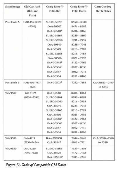
To determine whether the matching radiocarbon ranges represent a genuine connection or a random coincidence, the Stonehenge Code applies a probability test.
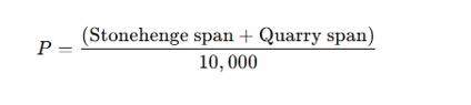
The model compares each Stonehenge radiocarbon range with the radiocarbon ranges from the quarry samples. A match is counted when the entire quarry range falls within the Stonehenge range.
To estimate the likelihood of such matches occurring by chance, the calculation assumes that any quarry date could fall anywhere within a 10,000-year Mesolithic window spanning 10,500 BCE to 500 BCE.
The probability of a complete overlap is calculated using the following formula:
For example:
HAR-455 spans 1083 years.
A quarry sample spans 220 years.

This corresponds to odds of approximately 1 in 7.67.
The probabilities of all observed overlaps are then multiplied together to determine the overall likelihood that the complete pattern of matches could occur by chance.
Applying this method to the full dataset produces the following combined probabilities:
| Stonehenge Sample | Quarry Matches | Combined Probability |
| HAR-455 | 12 | 2.29 × 10⁻¹¹ |
| GU-5109 | 10 | 4.41 × 10⁻¹² |
| HAR-456 | 1 | 7.70 × 10⁻² |
| QxA-4219 | 2 | 3.38 × 10⁻³ |
| QxA-4220 | 3 | 2.99 × 10⁻⁴ |
When these probabilities are multiplied together, the overall probability that the observed pattern of overlaps occurred randomly becomes approximately:
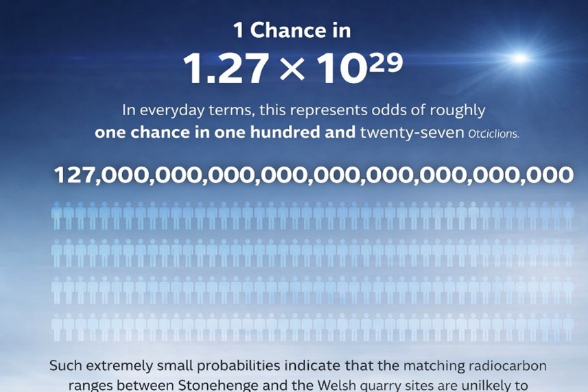
1 chance in 1.27 × 10²⁹
In everyday terms, this represents odds of roughly one chance in one hundred and twenty-seven octillions.
Such extremely small probabilities indicate that the matching radiocarbon ranges between Stonehenge and the Welsh quarry sites are unlikely to be coincidental.
Instead, the data strongly suggest that both sets of samples belong to the same period of activity.
If this interpretation is correct, it implies that bluestone quarrying in Wales and activity at Stonehenge took place during the Mesolithic rather than the Neolithic.
This conclusion would push the earliest phase of Stonehenge back to approximately 8300 BCE, making the monument thousands of years older than previously believed.
The implications of this shift are profound.
If Stonehenge began in the Mesolithic period, the monument can no longer be understood solely as a construction of early farming communities. Instead, its origins would lie within a much earlier landscape inhabited by hunter-gatherer societies.
This possibility raises fundamental questions about the technological abilities, social organisation and environmental knowledge of Mesolithic populations in Britain.
It also suggests that the rivers and waterways of post-glacial Britain may have played a far greater role in the transport of monumental stones than previously assumed.
The statistical evidence presented in the Stonehenge Code therefore does more than propose an earlier date for Stonehenge. It invites a reconsideration of the entire prehistoric framework within which the monument has traditionally been understood.
For more detailed information, see our blog: https://prehistoric-britain.co.uk/the-stonehenge-code
PODCAST

Author’s Biography

Robert John Langdon, a polymathic luminary, emerges as a writer, historian, and eminent specialist in LiDAR Landscape Archaeology.
His intellectual journey has included stints as an astute scrutineer in government and major corporate bastions, spanning British Telecommunications, Cable and Wireless, British Gas, and the esteemed University of London.
A decade hence, Robert’s transition into retirement unfurled a chapter of insatiable curiosity. He immersed himself in Politics, Archaeology, Philosophy, and the enigmatic realm of Quantum Mechanics. His academic odyssey took him through the venerable corridors of knowledge hubs such as the Museum of London, University College London, Birkbeck College, The City Literature Institute, and Chichester University.
In the symphony of his life, Robert is a custodian of three progeny and a pair of cherished grandchildren. His sanctuary lies ensconced in the embrace of West Wales, where he inhabits an isolated cottage, its windows framing a vista of the boundless sea – a retreat from the scrutinising gaze of Her Majesty’s Revenue and Customs, an amiable clandestinity in the lap of nature.
Exploring Prehistoric Britain: A Journey Through Time
My blog delves into the fascinating mysteries of prehistoric Britain, challenging conventional narratives and offering fresh perspectives grounded in cutting-edge research, particularly LiDAR technology. I invite you to explore some key areas of my research. For example, I re-examine the Wansdyke, often cited as a defensive structure, in light of new evidence. I’ve presented my findings in my blog post Wansdyke: A British Frontier Wall – ‘Debunked’, and a Wansdyke LiDAR Flyover video further visualises my conclusions.
My work also often challenges established archaeological dogma. I argue that many sites, such as Hambledon Hill, commonly identified as Iron Age hillforts, are not what they seem. My posts Lidar Investigation Hambledon Hill – NOT an ‘Iron Age Fort’ and Unmasking the “Iron Age Hillfort” Myth explore these ideas in detail and offer an alternative view. Similarly, I re-evaluated sites like Cissbury Ring and White Sheet Camp through LiDAR analysis in my posts “Lidar Investigation Cissbury Ring through time” and “Lidar Investigation White Sheet Camp,“ revealing fascinating insights into their true purpose. I have also examined South Cadbury Castle, often linked to the mythical Camelot56.
My research also extends to ancient water management, including the role of canals and other linear earthworks. I have discussed the true origins of Car Dyke in multiple posts, including Car Dyke – ABC News Podcast and Lidar Investigation Car Dyke – North Section, which suggest a Mesolithic origin 2357. I also explore the misidentification of Roman aqueducts, as seen in my posts on the Great Chesters (Roman) Aqueduct. My research has also been greatly informed by my post-glacial flooding hypothesis, which has helped explain landscape transformations over time. I have discussed this hypothesis in several posts, including AI now supports my Post-Glacial Flooding Hypothesis and Exploring Britain’s Flooded Past: A Personal Journey
Finally, my blog also investigates prehistoric burial practices, as seen in Prehistoric Burial Practices of Britain and explores the mystery of Pillow Mounds, often mistaken for medieval rabbit warrens, but with a potential link to Bronze Age cremation in my posts: Pillow Mounds: A Bronze Age Legacy of Cremation? and The Mystery of Pillow Mounds: Are They Really Medieval Rabbit Warrens?. My research also includes astronomical insights into ancient sites, for example, in Rediscovering the Winter Solstice: The Original Winter Festival. I also review new information about the construction of Stonehenge in The Stonehenge Enigma.
Yes. I’d make this far tighter, more inviting and more obviously a gateway into the rest of your work. The present version repeats the website several times and reads more like an author biography than a “what next?” section.
I’d also make the three routes immediately obvious: Explore the Research → Watch the Videos → Read the Books, with Facebook as the discussion/community route.
Further Reading — Explore the Evidence
The investigation doesn’t end with this article.
Prehistoric Britain brings together hundreds of articles, LiDAR investigations, field discoveries, archaeological studies and original research exploring Britain’s prehistoric landscape from a different perspective.
Follow the evidence across ancient waterways, lost landscapes, Stonehenge and Avebury, prehistoric engineering, submerged Britain, ancient DNA and the effects of post-glacial flooding — comparing established archaeological interpretations with alternative explanations suggested by the physical evidence.
🎬 Watch the Investigations
Prefer to watch rather than read?
The Robert John Langdon YouTube channel has more than 200 documentaries, investigations, and video presentations that bring the research to life through maps, LiDAR, archaeological evidence, and landscape reconstruction.
Discover investigations including 13 Things That Don’t Make Sense in History, Silbury Avenue – The Lost Stone Avenue, Stonehenge, prehistoric waterways, submerged landscapes and many more.
📚 Explore the Book Library
Go deeper into the evidence through Robert John Langdon’s growing collection of books and specialist studies, including:
- The Stonehenge Hoax – 13 Things That Don’t Make Sense in History
- Car Dyke – Prehistoric Dyke
- Wansdyke – Prehistoric Dyke
- Offa’s Dyke – Prehistoric Dyke
- Silbury Avenue – The Lost Stone Avenue
- The Vallum – At Hadrian’s Wall
- Stonehenge: The World’s First Computer
- Avebury’s Lost Stone Avenue
Many of these investigations connect directly with the evidence discussed throughout the website, allowing individual discoveries to be examined as part of the much wider prehistoric landscape.
🔎 Read the Main Trilogy
Three major works bring together the central strands of the research:
The Post-Glacial Flooding Hypothesis — investigates the evidence for radically different water levels, waterways and landscapes in prehistoric Britain.
The Stonehenge Enigma — re-examines the chronology, landscape and purpose of one of the world’s most famous prehistoric monuments.
Dawn of the Lost Civilisation — explores the evidence for sophisticated communities, technology and maritime connections far earlier than traditionally assumed.
💬 Join the Investigation
New discoveries, LiDAR surveys and research are discussed as they happen in the Prehistoric Britain Facebook Group.
Join the discussion, challenge the evidence, offer alternative interpretations and follow new investigations as they develop.
Don’t just read the accepted story. Explore the evidence, compare the interpretations, and decide for yourself.
Other Blogs
1
a
- Ackling Dyke – Facts and the Archaeological Fiction
- Ackling Dyke – Part II – Puddletown Forest: When a Roman Road Becomes an Assumption
- Ackling Dyke – Part III – The Roman Road Mystery Finally Makes Sense
- AI now Supports – Homo Superior
- AI now supports my Post-Glacial Flooding Hypothesis
- Alexander the Great sailed into India – where no rivers exist today
- Ancient Secrets of Althorp – debunked
- Antler Picks built Ancient Monuments – yet there is no real evidence
- Antonine Wall – Prehistoric Canals (Dykes)
- Archaeological ‘pulp fiction’ – has archaeology turned from science?
- Archaeological Pseudoscience
- Archaeology in the Post-Truth Era
- Archaeology: A Bad Science?
- Archaeology: A Harbour for Fantasists?
- Archaeology: Fact or Fiction?
- Archaeology: The Flaws of Peer Review
- Archaeology’s Bayesian Mistake: Stop Averaging the Past
- Are Raised Beaches Archaeological Pseudoscience?
- Atlantis Found: The Mathematical Proof That Plato’s Lost City Was Doggerland
- ATLANTIS: Discovery with Dan Snow Debunked
- Avebury Ditch – Avebury Phase 2
- Avebury through time
- Avebury’s great mystery revealed
- Avebury’s Lost Stone Avenue – Flipbook
b
- Battlesbury Hill – Wiltshire
- Beyond Stone and Bone: Rethinking the Megalithic Architects of Northern Europe
- BGS Prehistoric River Map
- Blackhenge: Debunking the Media misinterpretation of the Stonehenge Builders
- Brain capacity (Cro-Magnon Man)
- Britain’s First Road – Stonehenge Avenue
- Britain’s Giant Prehistoric Waterways
- British Roman Ports miles away from the coast
c
- Caerfai Promontory Fort – Archaeological Nonsense
- Car Dyke – ABC News PodCast
- Car Dyke – North Section
- Cardigan Bay: The Holocene Evidence the Old Geological Story Has Missed
- CASE STUDY – An Inconvenient TRUTH (Craig Rhos Y Felin)
- Case Study – River Avon
- Case Study – Woodhenge Reconstruction
- Chapter 2 – Craig Rhos-Y-Felin Debunked
- Chapter 2 – Stonehenge Phase I
- Chapter 2 – Variation of the Species
- Chapter 3 – Post Glacial Sea Levels
- Chapter 3 – Stonehenge Phase II
- Chapter 7 – Britain’s Post-Glacial Flooding
- Cissbury Ring through time
- Clement Reid, Doggerland, and the Archaeological Establishment
- Cro-Magnon Brain Capacity
- Cro-Magnon Megalithic Builders: Measurement, Biology, and the DNA
- Cro-Magnons – An Explainer
d
- Darwin’s Children – Flipbook
- Darwin’s Children – The Cro-Magnons
- Dawn of The Lost Civilisation – 1/10
- Dawn of the Lost Civilisation – Flipbook
- Dawn of the Lost Civilisation – Introduction
- Digging for Britain – Cerne Abbas
- Digging for Britain Debunked – Cerne Abbas 2
- Digging Up Britain’s Past – Debunked
- DLC Chapter 1 – The Ascent of Man
- Durrington Walls – Woodhenge through time
- Durrington Walls Revisited: Platforms, Fish Traps, and a Managed Mesolithic Landscape
- Dyke Construction – Hydrology 101
- Dykes Ditches and Earthworks
- DYKES of Britain
e
f
g
h
- Hadrian’s Wall – Military Way Hoax
- Hadrian’s Wall – the Stanegate Hoax
- Hadrian’s Wall Vallum – Prehistoric Canals – FREE Online Book
- Hadrian’s Wall LiDAR investigation
- Hambledon Hill – NOT an ‘Iron Age Fort’
- Hayling Island Lidar Maps
- Hidden Sources of Ancient Dykes: Tracing Underground Groundwater Fractals
- Historic River Avon
- Hollingsbury Camp Brighton – A Hillfort… or a Forgotten Harbour?
- Hollows, Sunken Lanes and Palaeochannels
- Homo Superior – Flipbook
- Homo Superior – History’s Giants
- How Lidar will change Archaeology
- Hydrology 101 Simplified: Why Britain’s Dykes Worked Without Rivers
i
l
m
- Maiden Castle through time
- Mathematics Meets Archaeology: Discovering the Mesolithic Origins of Car Dyke
- Mesolithic River Avon
- Mesolithic Stonehenge
- Minerals found in Prehistoric and Roman Quarries
- Mining in the Prehistoric to Roman Period
- Mount Caburn through time
- Mysteries of the Oldest Boatyard Uncovered
- Mythological Dragons – a non-existent animal that is shared by the World.
o
- Offa’s Dyke Flipbook
- Old Sarum Lidar Map
- Old Sarum Through Time…………….
- On Sunken Lands of the North Sea – Lived the World’s Greatest Civilisation.
- OSL Chronicles: Questioning Time in the Geological Tale of the Avon Valley
- Oswestry LiDAR Survey
- Oswestry through time
- Oysters in Archaeology: Nature’s Ancient Water Filters?
p
- Pillow Mounds: A Bronze Age Legacy of Cremation?
- Pinkery Canal
- Plato Was Right: The Archaeological Evidence the Academics Never Expected
- Post Glacial Flooding – Flipbook
- Prehistoric Burial Practices of Britain
- Prehistoric Canals – Wansdyke
- Prehistoric Canals – Wansdyke
- Prehistoric Canals (Dykes) – Great Chesters Aqueduct (The Vallum Pt. 4)
- Prehistoric Canals (Dykes) – Offa’s Dyke (Chepstow)
- Prehistoric Canals (Dykes) – Offa’s Dyke (LiDAR Survey)
- Prehistoric Canals (Dykes) – Offa’s Dyke Survey (End of Section A)
- Prehistoric Canals (Dykes) – Wansdyke (4)
- Prehistoric Canals Wansdyke 2
- Professor Bonkers and the mad, mad World of Archaeology
r
- Real-World Confirmation of Post-Glacial Flooding
- Rebirth in Stone: Decrypting the Winter Solstice Legacy of Stonehenge
- Rediscovering the Winter Solstice: The Original Winter Festival
- Rethinking Ancient Boundaries: The Vallum and Offa’s Dyke”
- Rethinking Ogham: Could Ireland’s Oldest Script Have Begun as a Tally System?
- Rethinking The Past: Mathematical Proof of Langdon’s Post-Glacial Flooding Hypothesis
- Revolutionising History: Car Dyke Unveiled as Prehistoric & the Launch of FusionBook 360
- Rising Evidence, Falling Rivers: The Real Story of Europe’s First Farmers
- Rivers of the Past Were Higher: A Fresh Perspective on Prehistoric Hydrology
s
- Sea Level Changes
- Section A – NY26SW
- Section B – NY25NE & NY26SE
- Section C – NY35NW
- Section D – NY35NE
- Section E – NY46SW & NY45NW
- Section F – NY46SE & NY45NE
- Section G – NY56SW
- Section H – NY56NE & NY56SE
- Section I – NY66NW
- Section J – NY66NE
- Section K – NY76NW
- Section L – NY76NE
- Section M – NY87SW & NY86NW
- Section N – NY87SE
- Section O – NY97SW & NY96NW
- Section P – NY96NE
- Section Q – NZ06NW
- Section R – NZ06NE
- Section S – NZ16NW
- Section T – NZ16NE
- Section U – NZ26NW & NZ26SW
- Section V – NZ26NE & NZ26SE
- Silbury Avenue – Avebury’s First Stone Avenue
- Silbury Hill
- Silbury Hill / Sanctuary – Avebury Phase 3
- Sky Maps of Prehistoric Britain
- Somerset Plain – Signs of Post-Glacial Flooding
- South Cadbury Castle – Camelot
- Statonbury Camp near Bath – an example of West Wansdyke
- Stone me – the druids are looking the wrong way on Solstice day
- Stone Transportation and Dumb Censorship
- Stonehenge – Monument to the Dead
- Stonehenge Hoax – Dating the Monument
- Stonehenge Hoax – Round Monument?
- Stonehenge Hoax – Summer Solstice
- Stonehenge LiDAR tour
- Stonehenge Phase 1 — Britain’s First Monument
- Stonehenge Phase I (The Stonehenge Landscape)
- Stonehenge Solved – Pythagorean maths put to use 4,000 years before he was born
- Stonehenge Through Time
- Stonehenge, Doggerland and Atlantis connection
- Stonehenge: Borehole Evidence of Post-Glacial Flooding
- Stonehenge: Discovery with Dan Snow Debunked
- Stonehenge: The World’s First Computer – FREE Book
- Stonehenge: The Worlds First Computer
- Stonehenge’s The Lost Circle Revealed – DEBUNKED
- Stonehenge’s Chronological Mirage
t
- Ten Reasons Why Car Dyke Blows Britain’s Earthwork Myths Out of the Water
- Ten Things You Didn’t Know About Britain’s Prehistoric Flooded Past
- Ten thousand year old boats found on Northern Europe’s Hillsides
- Ten thousand-year-old boats found on Northern Europe’s Hillsides
- Testing Plato’s Atlantis Against Reality
- The “Hunter-Gatherer” Myth: Why It’s Time to Bury This Outdated Term
- The Ackling Dyke Smoking Gun
- The Ancient Mariners – Flipbook
- The Ancient Mariners – Prehistoric seafarers of the Mesolithic
- The Ascent of Man — From Survival to Systems
- The Beringian Migration Myth: Why the Peopling of the Americas by Foot is Mathematically and Logistically Impossible
- The Bluestone Enigma
- The Bulford Hoax: The “Simpler, Older Stonehenge” That Wasn’t
- The Cheddar Man Hoax
- The Cro-Magnon Cover-Up: How DNA and PR Labels Erased Our Real Ancestry
- The Dolmen and Long Barrow Connection
- The Durrington Mega-Monument Hoax: What Lies Beneath? – Debunked
- The Durrington Walls Hoax – it’s not a henge?
- The Dyke Myth Collapses: Excavation and Dating Prove Britain’s Great Dykes Are Prehistoric Canals
- The First European Smelted Bronzes
- The Fury of the Past: Natural Disasters in Historical and Prehistoric Britain
- The Giant’s Graves of Cumbria
- The Giants of Prehistory: Cro-Magnon and the Ancient Monuments
- The Great Ancient DNA Illusion: How Statistical Models Became Archaeological “Facts”
- The Great Antler Pick Hoax
- The Great Bell Beaker Migration Myth
- The Great Chichester Hoax – A Bridge too far?
- The Great Dorchester Aqueduct Hoax
- The Great Farming Hoax – (Einkorn Wheat)
- The Great Farming Migration Hoax
- The Great Hadrian’s Wall Hoax
- The Great Iron Age Hill Fort Hoax
- The Great Offa’s Dyke Hoax
- The Great Prehistoric Migration Hoax
- The Great Stone Transportation Hoax
- The Great Stonehenge Hoax
- The Great Wansdyke Hoax
- THE GREAT WEST WOODS HOAX — WHEN ONE STONE BECOMES FIFTY
- The Henge and River Relationship
- The Logistical Impossibility of Defending Maiden Castle
- The Long Barrow and Dolmen Enigma
- The Long Barrow Mystery
- The Long Barrow Mystery: Unravelling Ancient Connections
- The Lost Island of Avalon – revealed
- The Maiden Way Hoax – A Closer Look at an Ancient Road’s Hidden History
- The Maths – LGM total ice volume
- The Mystery of Pillow Mounds: Are They Really Medieval Rabbit Warrens?
- THE ODYSSEY PROBLEM: WHY DID A WEEK-LONG VOYAGE BECOME A TEN-YEAR EPIC?
- The Old Sarum Hoax
- The Oldest Boat Yard in the World found in Wales
- The Perils of Paradigm Shifts: Why Unconventional Hypotheses Get Branded as Pseudoscience
- The Post-Glacial Flooding Hypothesis – 1/11
- The Post-Glacial Flooding Hypothesis – Flipbook
- The Post-Glacial Flooding Theory
- The Problem with Hadrian’s Vallum
- The Rise of the Cro-Magnon (Homo Superior)
- The Roman Military Way Hoax
- The Silbury Hill Lighthouse?
- The Stone Money – Credit System
- The Stonehenge Avenue
- The Stonehenge Avenue
- The Stonehenge Code: Unveiling its 10,000-Year-Old Secret
- The Stonehenge Crescent: A Monument to a Lost World
- The Stonehenge Enigma – Flipbook
- The Stonehenge Enigma: Part 1/6
- The Stonehenge Hoax – Bluestone Quarry Site
- The Stonehenge Hoax – Flipbook
- The Stonehenge Hoax – Moving the Bluestones
- The Stonehenge Hoax – Periglacial Stripes
- The Stonehenge Hoax – Station Stones
- The Stonehenge Hoax – Stonehenge’s Location
- The Stonehenge Hoax – The Ditch
- The Stonehenge Hoax – The Slaughter Stone
- The Stonehenge Hoax – The Stonehenge Layer
- The Stonehenge Hoax – Totem Poles
- The Stonehenge Hoax – Woodhenge
- The Stonehenge Hospital
- The Stonehenge Transportation Mystery
- The Subtropical Britain Hoax
- The Troy, Hyperborea and Atlantis Connection
- The Vallum @ Hadrian’s Wall – it’s Prehistoric!
- The Vallum at Hadrian’s Wall (Summary)
- The Woodhenge Hoax
- Thirty Years of CAU Archaeology Going Nowhere?
- Three Dykes – Kidland Forest
- Thurnam’s 137 Skulls: The Forgotten People Behind Britain’s Megaliths.
- Top Ten Misidentified Fire Beacons in British History
- Troy Debunked – Troy did not exist in Asia Minor, but in fact, the North Sea island of Doggerland
- TSE – DVD Barrows
- TSE DVD – An Inconvenient Truth
- TSE DVD – Antler Picks
- TSE DVD – Avebury
- TSE DVD – Durrington Walls & Woodhenge
- TSE DVD – Dykes
- TSE DVD – Epilogue
- TSE DVD – Stonehenge Phase I
- TSE DVD – Stonehenge Phase II
- TSE DVD – The Post-Glacial Hypothesis
- TSE DVD Introduction
- TSE DVD Old Sarum
- Twigs, Charcoal, and the Death of the Saxon Dyke Myth
w
- Wansdyke – Short Film
- Wansdyke East – Prehistoric Canals
- Wansdyke Flipbook
- Wansdyke LiDAR Flyover
- Wansdyke: A British Frontier Wall – ‘Debunked’
- Was Columbus the first European to reach America?
- What Archaeology Missed Beneath Stonehenge
- White Sheet Camp
- Why a Simple Fence Beats a Massive Dyke (and What That Means for History)
- Windmill Hill – Avebury Phase 1
- Winter Solstice – Science, Propaganda and Indoctrination
- Woodhenge – the World’s First Lighthouse?