Prehistoric Dorset Canals (Dykes)
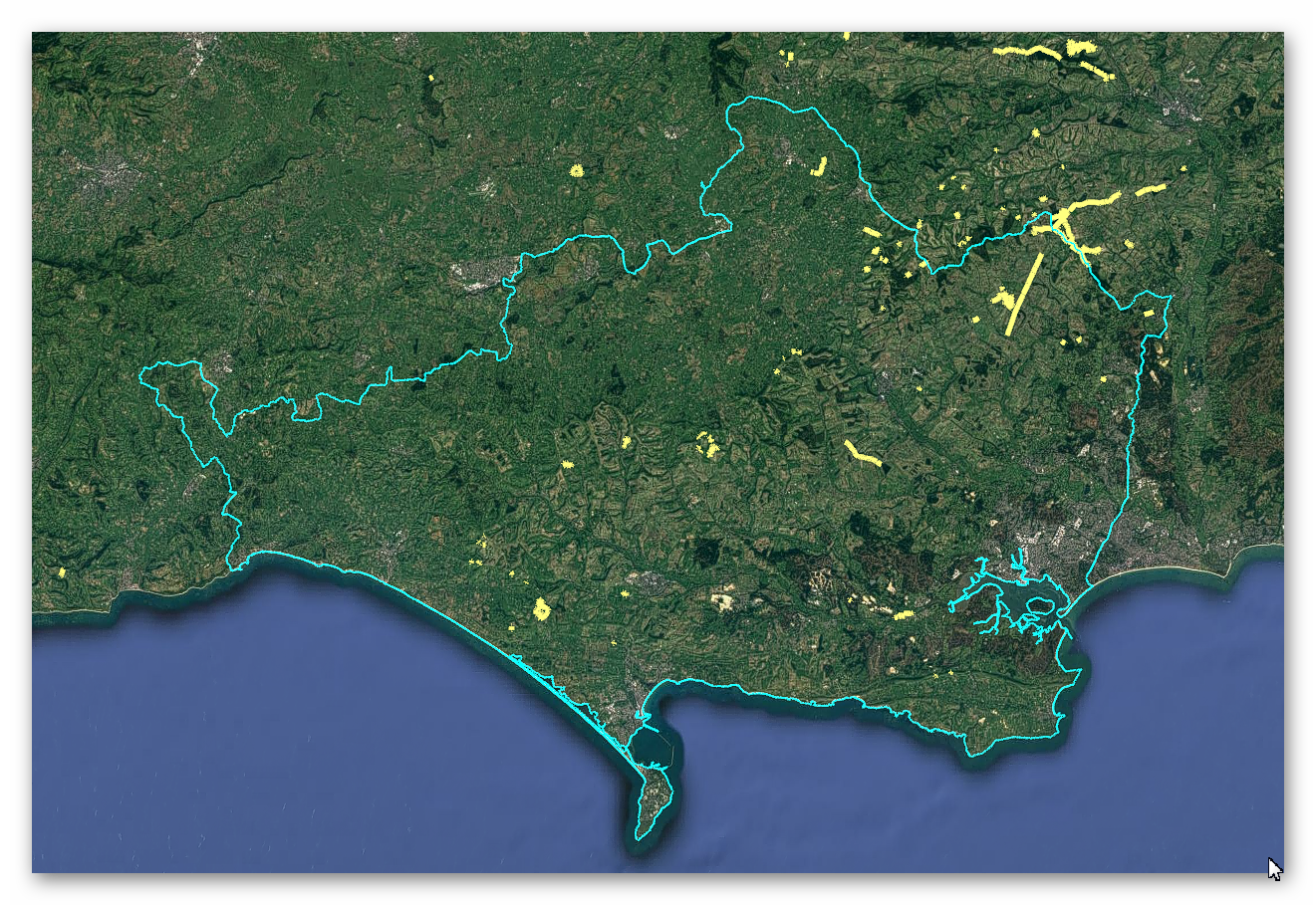
GE Map of Prehistoric Dorset Canals (Dykes)

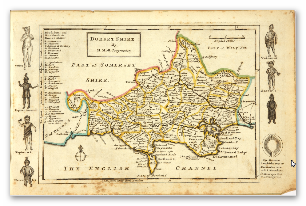
Old Map

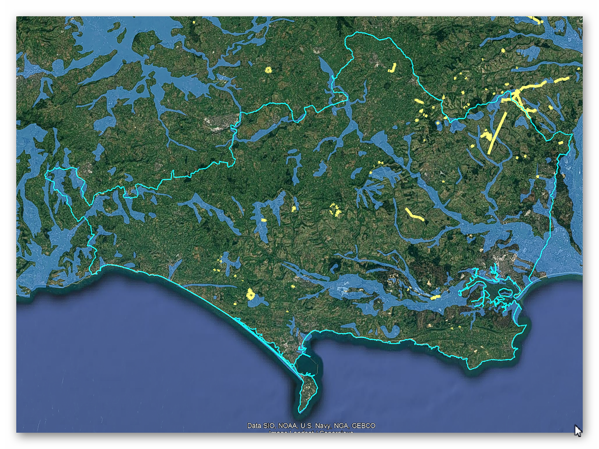
Geological Landscape

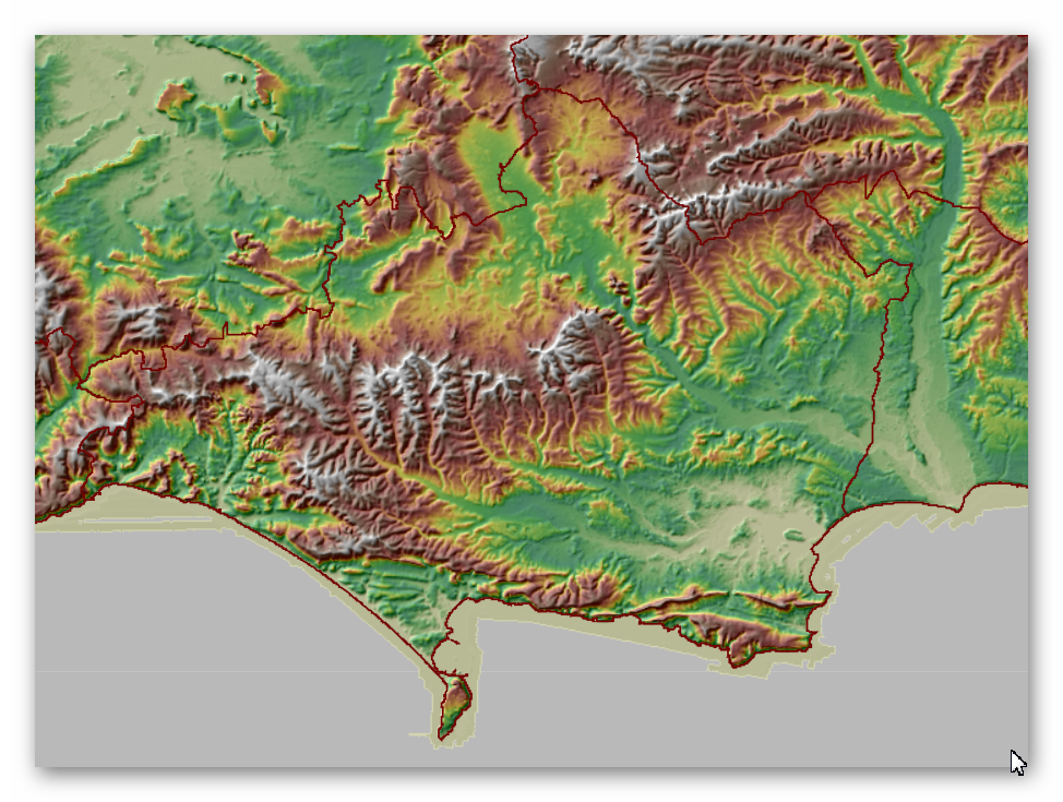
Landscape/Terrain

Database of DYKES (Linear Earthworks) in Dorset
(Click the ‘HE Entry Ref: Number’ (if blue) for more details and Maps)
| Name | HE Entry Ref: | NGF | Length (m) | Overall Width (m) | Ditch Width (m) | Bank Width (m) |
|---|---|---|---|---|---|---|
| Boundary banks on Rye Hill and in Maldry Wood | 1002381 | SU 05424 10513 | ||||
| Gillingham Park boundary bank | 1002382 | ST 83430 24759 | ||||
| Length of deer park bank and ditch at Alderholt | 1002394 | SU 11425 12783 | ||||
| Combe Ditch, linear dyke | 1002400 | ST 87253 00629 | ||||
| Dyke SE of Eggardon Hill camp | 1002404 | SY 54830 94261 | ||||
| Field system in Valley of Stones (including earthwork N of Crow Hill) | 1002431 | SY 59548 88549 | ||||
| Earthworks in Ditchey Coppice | 1002448 | ST 88678 13321 | ||||
| Linear earthworks around Lyscombe Bottom | 1002454 | ST 73177 02625 | ||||
| Earthwork and ancient fields SE of Lyscombe Bottom | 1002456 | ST 74480 01516 | ||||
| Earthworks on Thickthorn Down | 1002457 | ST 96665 12317 | ||||
| Cross-ridge dyke on Rawston Down | 1002462 | ST 91801 06437 | ||||
| Dyke on Long Barrow Hill | 1002688 | SY 57084 91065 | ||||
| Earthworks on Giant Hill | 1002725 | ST 66759 01868 | ||||
| Dyke on Wears Hill | 1002732 | SY 57062 86382 | ||||
| Earthwork 80yds (70m) long NW of Coombe Bottom | 1002734 | SY 54329 93706 | ||||
| Dyke on Haydon Down | 1002735 | SY 54791 93472 | ||||
| Cross-ridge dyke on Windsbatch | 1002753 | SY 65734 85081 | ||||
| Two barrows near Ackling Dyke | 1002786 | SU 00582 14303 | ||||
| Earthworks on Askerswell Down | 1003214 | SY 53661 92014 | ||||
| Part of Ackling Dyke (Roman road), including Roman road on Oakley Down | 1003309 | SU 00923 14905 | ||||
| Cross dyke 600m north of Pitcombe Farm | 1011695 | SY 58336 90256 | ||||
| Bokerley Dyke, and a section of Grim's Ditch, a section of a medieval boundary bank, and two bowl barrows on and north west of Martin Down | 1012135 | SU 02361 20034 | ||||
| Two sections of a linear earthwork north of West Woodyates Manor: part of the `Bokerley Line' | 1012136 | SU 02486 19949 | ||||
| A linear earthwork north east of West Woodyates Manor: part of the `Bokerley Line' | 1012138 | SU 02343 19898 | ||||
| The western of two linear earthworks north of West Woodyates Manor | 1012139 | SU 01559 19630 | ||||
| The eastern of two linear earthworks north of West Woodyates Manor | 1012140 | SU 01762 19664 | ||||
| Bowl barrow and cross dyke on Knowle Hill, 500m NNE of St Peter's Church | 1014838 | SY 94389 82371 | ||||
| Cross dyke on Knowle Hill, 470m SSE of East Creech Farm | 1014842 | SY 93163 82104 | ||||
| Cross dyke on Knowle Hill, 430m south of East Creech Farm | 1014843 | SY 93047 82122 | ||||
| Battery Bank: a linear boundary on Great Plantation, 450m north east of Woodside | 1015347 | SY 85856 88573 | ||||
| Long barrow, three bell barrows, fancy barrow and a linear earthwork 800m north of Maiden Castle | 1015783 | SY 66549 89265 | ||||
| Cross dyke and bowl barrow on Bell Hill 690m north east of Baker's Folly | 1016686 | ST 79682 07996 | ||||
| Cross dyke on Okeford Hill 1km south west of Broughton House | 1016689 | ST 81685 09579 | ||||
| Cross dyke on Okeford Hill 880m south east of Hartcliff Farm | 1016690 | ST 81134 09702 | ||||
| Cross dyke and linear boundary on Melbury Hill and Compton Down | 1016894 | ST 87797 19730 | ||||
| Group of linear earthworks on Worgret Heath | 1018187 | SY 89778 87076 | ||||
| Linear earthwork on Wareham Common, 350m north west and 420m north east of Little Farm | 1018194 | SY 90738 87405 | ||||
| Bowl barrow cemetery and a cross dyke on Horton Common 800m south of Bridge Farm | 1018411 | SU 07535 07230 | ||||
| Cross dyke 480m and 690m NNW of Fontmell Hill House | 1019028 | ST 88965 17317 | ||||
| Cross dyke on Bell Hill 610m east of Brooks Farm | 1019363 | ST 80276 09097 | ||||
| Medieval strip lynchets 450m south of Springhead Farm | 1020028 | ST 87397 16609 | ||||
| Two cross dykes on Fontmell Down, 850m and 880m south east of Gourd's Farm | 1020361 | ST 88289 18244 | ||||
| Cross ridge dyke 140m north and 70m south of Hatts Barn | 1020610 | ST 90130 18791 | ||||
| Linear boundary 870m south west of Spring Farm | 1020729 | ST 90887 16118 |
Dykes Ditches and Earthworks
Indeed, the modern term “dyke” or “dijk” can be traced back to its Dutch origins. As early as the 12th century, the construction of Dykes in the Netherlands was a well-established practice. One remarkable example of their ingenuity is the Westfriese Omringdijk, stretching an impressive 126 kilometres (78 miles), completed by 1250. This Dyke was formed by connecting existing older ‘dykes’, showcasing the Dutch mastery in managing their aquatic landscape.
The Roman chronicler Tacitus even provides an intriguing historical account of the Batavi, a rebellious people who employed a unique defence strategy during the year AD 70. They punctured the Dykes daringly, deliberately flooding their land to thwart their enemies and secure their retreat. This historical incident highlights the vital role Dykes played in the region’s warfare and water management.
Originally, the word “dijk” encompassed both the trench and the bank, signifying a comprehensive understanding of the Dyke’s dual nature – as both a protective barrier and a channel for water control. This multifaceted concept reflects the profound connection between the Dutch people and their battle against the ever-shifting waters that sought to reclaim their land.
The term “dyke” evolved as time passed, and its usage spread beyond the Dutch borders. Today, it represents not only a symbol of the Netherlands’ engineering prowess but also a universal symbol of human determination in the face of the relentless forces of nature. The legacy of these ancient Dykes lives on, a testament to the resilience and innovation of those who shaped the landscape to withstand the unyielding currents of time.
Upon studying archaeology, whether at university or examining detailed ordinance survey maps, one cannot help but encounter peculiar earthworks scattered across the British hillsides. Astonishingly, these enigmatic features often lack a rational explanation for their presence and purpose. Strangely enough, these features are frequently disregarded in academic circles, brushed aside, or provided with flimsy excuses for their existence. The truth is, these earthworks defy comprehension unless we consider overlooked factors at play.
One curious observation revolves around the term “Dyke,” inherently linked to water. It seems rather peculiar to apply such a word to an earthwork atop a hill unless an ancestral history has imparted its actual function through the ages. Let us consider the celebrated “Offa’s Dyke,” renowned for its massive linear structure, meandering along some of the present boundaries between England and Wales. This impressive feat stands as a testament to the past, seemingly demarcating the realms of the Anglian kingdom of Mercia and the Welsh kingdom of Powys during the 8th century.
However, delving further into the evidence and historical accounts challenges this seemingly straightforward explanation. Roman historian Eutropius, in his work “Historiae Romanae Breviarium”, penned around 369 AD, mentions a grand undertaking by Septimius Severus, the Roman Emperor, from 193 AD to 211 AD. In his pursuit of fortifying the conquered British provinces, Severus constructed a formidable wall stretching 133 miles from coast to coast.
Yet, intriguingly, none of the known Roman defences match this precise length. Hadrian’s Wall, renowned for its defensive prowess, spans a mere 70 miles. Could Eutropius have referred to Offa’s Dyke, which bears remarkable similarity to the Roman practice of initially erecting banks and ditches for defence?
For more information click HERE
Further Reading
For information about British Prehistory, visit www.prehistoric-britain.co.uk for the most extensive archaeology blogs and investigations collection, including modern LiDAR reports. This site also includes extracts and articles from the Robert John Langdon Trilogy about Britain in the Prehistoric period, including titles such as The Stonehenge Enigma, Dawn of the Lost Civilisation and the ultimate proof of Post Glacial Flooding and the landscape we see today.
Robert John Langdon has also created a YouTube web channel with over 100 investigations and video documentaries to support his classic trilogy (Prehistoric Britain). He has also released a collection of strange coincidences that he calls ‘13 Things that Don’t Make Sense in History’ and his recent discovery of a lost Stone Avenue at Avebury in Wiltshire called ‘Silbury Avenue – the Lost Stone Avenue’.
Langdon has also produced a series of ‘shorts’, which are extracts from his main body of books:
For active discussions on the findings of the TRILOGY and recent LiDAR investigations that are published on our WEBSITE, you can join our and leave a message or join the debate on our Facebook Group.
