The Great Chichester Hoax – A Bridge too far?
Contents
Introduction
It seems I’ve once again stirred up some controversy among the old archaeology club members of Chichester. A few years back, there was quite a buzz in Chichester when they unearthed a Roman Villa complete with a bathhouse. Eager to contribute, I headed to the site with my drone, hoping to capture aerial shots. However, my offer was turned down, perhaps due to the slew of questions I posed to the lead archaeologist. I was particularly intrigued by the water sourcing and drainage for the bathhouse, especially given the presence of the prehistoric dyke that ran through the park. Yet, they seemed to disregard the sizable bank at the edge of the cricket ground. (The Great Chichester Hoax – A Bridge too far?)
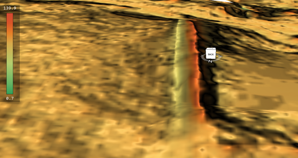
Roman Drain
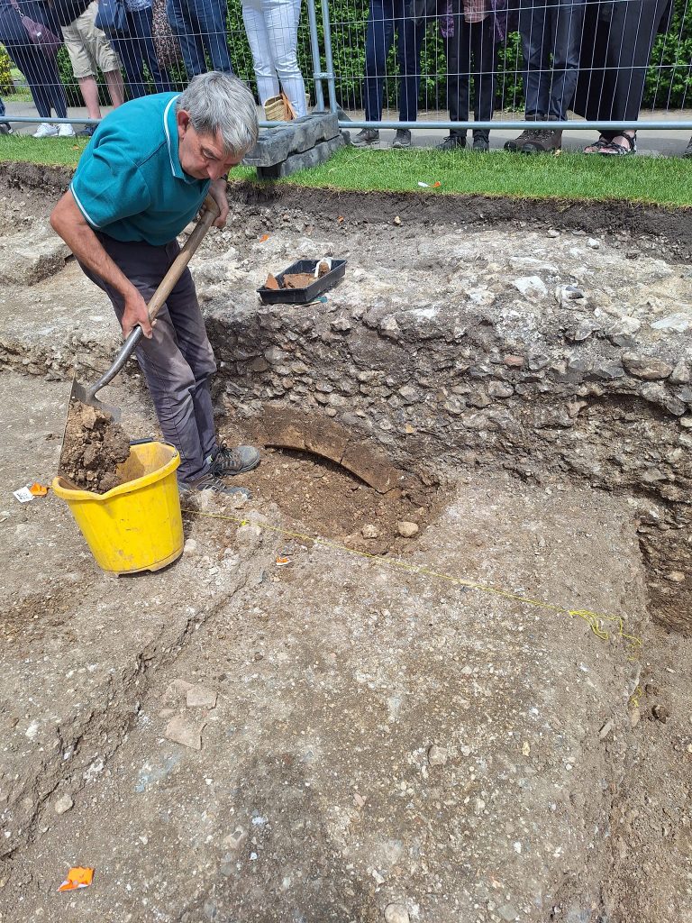
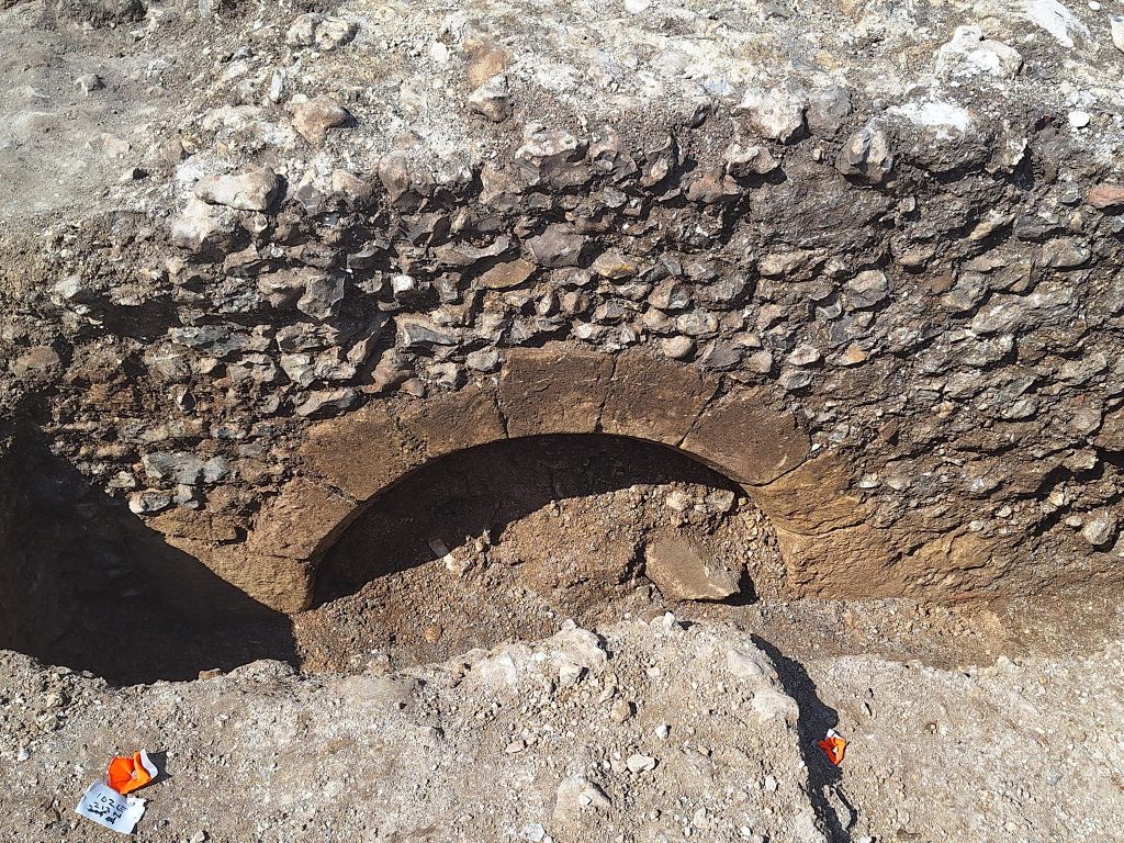
Now, they’ve uncovered another segment that I firmly believe is part of the Roman drainage system, connecting to the Dyke in a direct line. However, they’ve made a somewhat surprising claim—they think it’s a bridge to the Motte and Bailey castle (but that’s another story, as it’s a fire beacon). Unfortunately, from the photographs, it appears relatively small and insufficient to be a bridge. Nevertheless, this small group of amateurs called in the local press, who then informed the BBC to tout this as a historical find, even though it’s yet to be fully excavated—an oversight I’ve dubbed “The Great Chichester Hoax.”
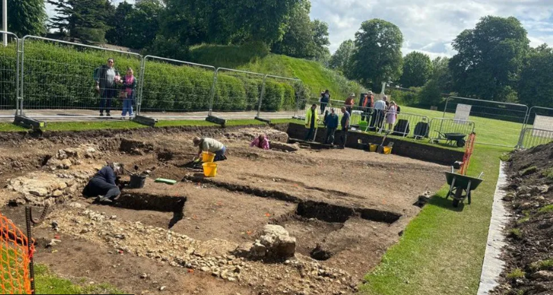
Sadly, this scenario reflects the current state of archaeology. Some quickly accept sensational claims simply because they’re featured on the BBC, ignoring scientific facts. It’s disappointing to see more propaganda overshadowing genuine archaeological inquiry. (The Great Chichester Hoax – A Bridge too far?)
Motte and Bailey?
Living and commuting past this site every day while attending university in recent years (and yes, to disappoint the sceptics, I do hold an Honors Degree in History), I couldn’t help but be amused by the public information board proclaiming it as a classic Motte and Bailey structure from the Norman period. Now, I never doubted its use during the Norman era, especially with the remains of Greyfriars Monastery, the Guildhall, at its base. This chapel had undergone modifications over the years, providing ample evidence for dating the site to this period. But was the mound of Norman origin knowing that a Dyke was nearby? There was a question that the local archaeological club did not wish to explore it seemed.(The Great Chichester Hoax – A Bridge too far?)
Undiscovered Dyke
What fascinated me most, however, was the massive bank on the edge of the Cricket Green, which had been paved over and led towards the mound and the eastern wall of the Guildhall. It almost seemed as if the building was strategically placed by the ditch of the Dyke. Yes, the presence of the Dyke was painfully obvious, yet its existence was never mentioned on the historic plaques or in the online information or countless books about Roman Chichester.(The Great Chichester Hoax – A Bridge too far?)
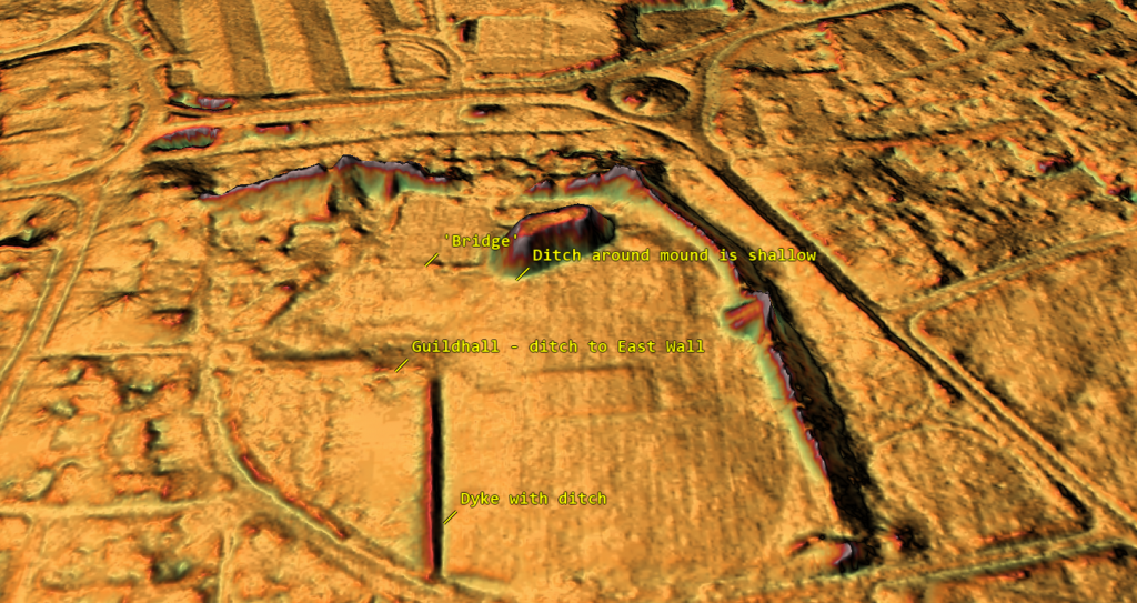
In response to the BBC article and Facebook blog, I (helpfully) pointed out these observations again and even provided one of my unique LiDAR maps of the area (which they had never possessed or consulted). I was, consequently, taken aback by their dismissive response, insisting that their experts were correct in their assessment of the site and the supposed new bridge (which had grown to over 15 meters, now supposedly the size of the moat—identified by ground penetration surveys, but frustratingly, not published anywhere for verification). I countered that this assessment was likely incorrect, as LiDAR would have easily detected such a massive ditch, as evidenced by the much smaller Dyke ditch of about 2 meters wide visible in the LiDAR map.(The Great Chichester Hoax – A Bridge too far?)
Report on the 1855 excavation
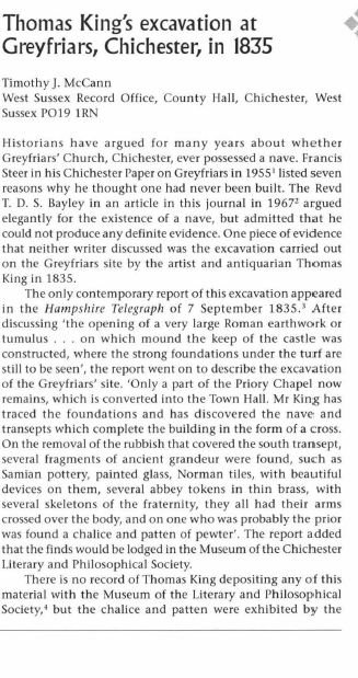
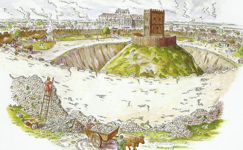
Moreover, I reminded them that this site had been excavated initially back in 1855, and the lead archaeologist, Thomas King, had reported that the mound was, in fact, a Roman tumulus. While it may have been repurposed or utilised in some way during the Norman period, it certainly does not fit the classic Motte and Bailey castle mound. How could Roman artefacts find their way into a mound supposedly built 600 years after the Romans had left? Their response was a concocted tale about scattered debris from the Roman period being accidentally left at the top of the mound as they built it from the spoil at the bottom and subsequent moated area. This notion seemed highly improbable to me. After all, one would assume that Thomas King, who conducted the formal investigation into the Greyfriars Church and mound by excavation in an attempt to find any connectivity between the two features and potential connections, would not arrive at such an unexpected conclusion based solely on a few scattered fragments of debris.(The Great Chichester Hoax – A Bridge too far?)
Fire Beacons
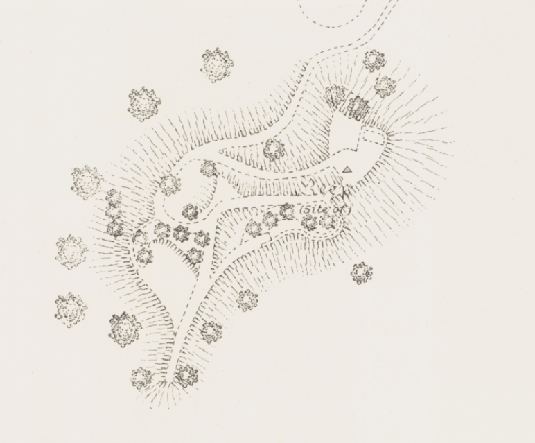
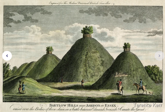
So, to further their understanding of Roman beacons, I included additional information they may not have been aware of. I suggested that if they were genuinely interested in the archaeology of the mound and its historical significance, they should consider visiting Lewes, just down the road—a place where I’ve lived and conducted surveys. In Lewes, they would find not one but two fire beacons. Interestingly, both have been misidentified again! The Trump, a mound serving as a fire beacon for the Cluny Monastery, was crucial in guiding ships from France into a safe harbour.
Lewes
I also mentioned another site associated with a real motte and bailey castle, Brack Hill. Initially thought to be part of the Norman Castle, recent finds of Roman artefacts suggest it dates back to pre-Norman times, possibly even Roman or earlier, serving as a fire beacon. This aligns with the historical context, as the town would have been a harbour, with The Brack situated right on the shoreline of the prehistoric river.
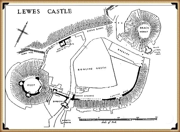
Cluny Monastry
Their response was rather dismissive, claiming that the Lewes Trump was not a fire beacon but nothing more than a garden feature— a mere 75 feet high and 140 feet in circumference. However, I argued that this seemed implausible for a mere “garden feature,” especially considering its location at the edge of the monastery’s grounds. I suggested they study a LiDAR map, which would reveal that The Trump, formerly known as The Mount, sits on the prehistoric shoreline of Lewes. Adjacent to it is another ancient site, the “dripping pan,” a salt production site for the Cluny Monks, requiring constant saltwater. This, I argued, provides empirical evidence supporting its role as a fire beacon—guiding French-origin ships off the English Channel to safe harbours and the monastery.
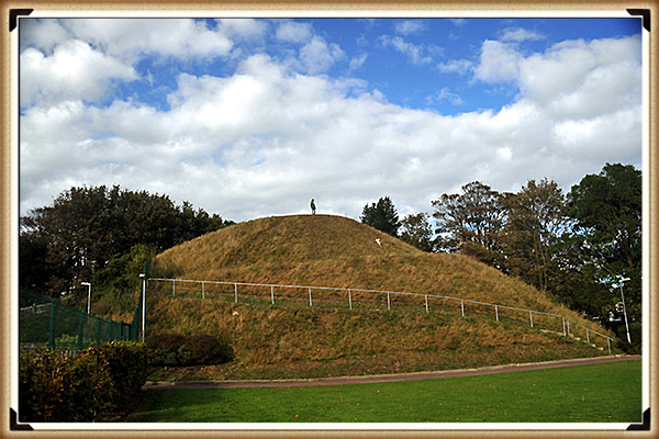
Unfortunately, my contributions were met with silence, as they seemed more interested in celebrating their historic bridge discovery rather than engaging in meaningful archaeological discussions, as they considered the matter closed. It’s disappointing to see archaeologists shut down debate and ignore valuable information, promoting unsupported propaganda instead of evidence-based inquiry. This closed-minded approach is a stark departure from authentic scientific practice, contributing to the devaluation of archaeology as a subject and the subsequent decline of related courses due to this ‘dumbing down’.(The Great Chichester Hoax – A Bridge too far?)
It is crucial to remain open to new interpretations and theories that might differ significantly from traditional views. The absence of evidence is not evidence of absence. Still, it does require us to question and reassess historical assumptions, ensuring our understanding of the past is as accurate as possible.

(The Great Chichester Hoax – A Bridge too far?)
Further Reading
For information about British Prehistory, visit www.prehistoric-britain.co.uk for the most extensive archaeology blogs and investigations collection, including modern LiDAR reports. This site also includes extracts and articles from the Robert John Langdon Trilogy about Britain in the Prehistoric period, including titles such as The Stonehenge Enigma, Dawn of the Lost Civilisation and the ultimate proof of Post Glacial Flooding and the landscape we see today.
Robert John Langdon has also created a YouTube web channel with over 100 investigations and video documentaries to support his classic trilogy (Prehistoric Britain). He has also released a collection of strange coincidences that he calls ‘13 Things that Don’t Make Sense in History’ and his recent discovery of a lost Stone Avenue at Avebury in Wiltshire called ‘Silbury Avenue – the Lost Stone Avenue’.
Langdon has also produced a series of ‘shorts’, which are extracts from his main body of books:
Other Blogs
1
a
- AI now Supports – Homo Superior
- AI now supports my Post-Glacial Flooding Hypothesis
- Alexander the Great sailed into India – where no rivers exist today
- Ancient Prehistoric Canals – The Vallum
- Ancient Secrets of Althorp – debunked
- Antler Picks built Ancient Monuments – yet there is no real evidence
- Antonine Wall – Prehistoric Canals (Dykes)
- Archaeological ‘pulp fiction’ – has archaeology turned from science?
- Archaeological Pseudoscience
- Archaeology in the Post-Truth Era
- Archaeology: A Bad Science?
- Archaeology: A Harbour for Fantasists?
- Archaeology: Fact or Fiction?
- Archaeology: The Flaws of Peer Review
- Archaeology’s Bayesian Mistake: Stop Averaging the Past
- Are Raised Beaches Archaeological Pseudoscience?
- Atlantis Found: The Mathematical Proof That Plato’s Lost City Was Doggerland
- ATLANTIS: Discovery with Dan Snow Debunked
- Avebury Ditch – Avebury Phase 2
- Avebury Post-Glacial Flooding
- Avebury through time
- Avebury’s great mystery revealed
- Avebury’s Lost Stone Avenue – Flipbook
b
- Battlesbury Hill – Wiltshire
- Beyond Stone and Bone: Rethinking the Megalithic Architects of Northern Europe
- BGS Prehistoric River Map
- Blackhenge: Debunking the Media misinterpretation of the Stonehenge Builders
- Brain capacity (Cro-Magnon Man)
- Brain capacity (Cro-Magnon Man)
- Britain’s First Road – Stonehenge Avenue
- Britain’s Giant Prehistoric Waterways
- British Roman Ports miles away from the coast
c
- Caerfai Promontory Fort – Archaeological Nonsense
- Car Dyke – ABC News PodCast
- Car Dyke – North Section
- CASE STUDY – An Inconvenient TRUTH (Craig Rhos Y Felin)
- Case Study – River Avon
- Case Study – Woodhenge Reconstruction
- Chapter 2 – Craig Rhos-Y-Felin Debunked
- Chapter 2 – Stonehenge Phase I
- Chapter 2 – Variation of the Species
- Chapter 3 – Post Glacial Sea Levels
- Chapter 3 – Stonehenge Phase II
- Chapter 7 – Britain’s Post-Glacial Flooding
- Cissbury Ring through time
- Cro-Magnon Megalithic Builders: Measurement, Biology, and the DNA
- Cro-Magnons – An Explainer
d
- Darwin’s Children – Flipbook
- Darwin’s Children – The Cro-Magnons
- Dawn of the Lost Civilisation – Flipbook
- Dawn of the Lost Civilisation – Introduction
- Digging for Britain – Cerne Abbas 1 of 2
- Digging for Britain Debunked – Cerne Abbas 2
- Digging Up Britain’s Past – Debunked
- DLC Chapter 1 – The Ascent of Man
- Durrington Walls – Woodhenge through time
- Durrington Walls Revisited: Platforms, Fish Traps, and a Managed Mesolithic Landscape
- Dyke Construction – Hydrology 101
- Dykes Ditches and Earthworks
- DYKES of Britain
e
f
g
h
- Hadrian’s Wall – Military Way Hoax
- Hadrian’s Wall – the Stanegate Hoax
- Hadrian’s Wall LiDAR investigation
- Hambledon Hill – NOT an ‘Iron Age Fort’
- Hayling Island Lidar Maps
- Hidden Sources of Ancient Dykes: Tracing Underground Groundwater Fractals
- Historic River Avon
- Hollingsbury Camp Brighton
- Hollows, Sunken Lanes and Palaeochannels
- Homo Superior – Flipbook
- Homo Superior – History’s Giants
- How Lidar will change Archaeology
i
l
m
- Maiden Castle through time
- Mathematics Meets Archaeology: Discovering the Mesolithic Origins of Car Dyke
- Mesolithic River Avon
- Mesolithic Stonehenge
- Minerals found in Prehistoric and Roman Quarries
- Mining in the Prehistoric to Roman Period
- Mount Caburn through time
- Mysteries of the Oldest Boatyard Uncovered
- Mythological Dragons – a non-existent animal that is shared by the World.
o
- Offa’s Dyke Flipbook
- Old Sarum Lidar Map
- Old Sarum Through Time…………….
- On Sunken Lands of the North Sea – Lived the World’s Greatest Civilisation.
- OSL Chronicles: Questioning Time in the Geological Tale of the Avon Valley
- Oswestry LiDAR Survey
- Oswestry through time
- Oysters in Archaeology: Nature’s Ancient Water Filters?
p
- Pillow Mounds: A Bronze Age Legacy of Cremation?
- Post Glacial Flooding – Flipbook
- Prehistoric Burial Practices of Britain
- Prehistoric Canals – Wansdyke
- Prehistoric Canals – Wansdyke
- Prehistoric Canals (Dykes) – Great Chesters Aqueduct (The Vallum Pt. 4)
- Prehistoric Canals (Dykes) – Hadrian’s Wall Vallum (pt 1)
- Prehistoric Canals (Dykes) – Offa’s Dyke (Chepstow)
- Prehistoric Canals (Dykes) – Offa’s Dyke (LiDAR Survey)
- Prehistoric Canals (Dykes) – Offa’s Dyke Survey (End of Section A)
- Prehistoric Canals (Dykes) – Wansdyke (4)
- Prehistoric Canals Wansdyke 2
- Professor Bonkers and the mad, mad World of Archaeology
r
- Rebirth in Stone: Decrypting the Winter Solstice Legacy of Stonehenge
- Rediscovering the Winter Solstice: The Original Winter Festival
- Rethinking Ancient Boundaries: The Vallum and Offa’s Dyke”
- Rethinking Ogham: Could Ireland’s Oldest Script Have Begun as a Tally System?
- Rethinking The Past: Mathematical Proof of Langdon’s Post-Glacial Flooding Hypothesis
- Revolutionising History: Car Dyke Unveiled as Prehistoric & the Launch of FusionBook 360
- Rising Evidence, Falling Rivers: The Real Story of Europe’s First Farmers
- Rivers of the Past Were Higher: A Fresh Perspective on Prehistoric Hydrology
s
- Sea Level Changes
- Section A – NY26SW
- Section B – NY25NE & NY26SE
- Section C – NY35NW
- Section D – NY35NE
- Section E – NY46SW & NY45NW
- Section F – NY46SE & NY45NE
- Section G – NY56SW
- Section H – NY56NE & NY56SE
- Section I – NY66NW
- Section J – NY66NE
- Section K – NY76NW
- Section L – NY76NE
- Section M – NY87SW & NY86NW
- Section N – NY87SE
- Section O – NY97SW & NY96NW
- Section P – NY96NE
- Section Q – NZ06NW
- Section R – NZ06NE
- Section S – NZ16NW
- Section T – NZ16NE
- Section U – NZ26NW & NZ26SW
- Section V – NZ26NE & NZ26SE
- Silbury Avenue – Avebury’s First Stone Avenue
- Silbury Hill
- Silbury Hill / Sanctuary – Avebury Phase 3
- Somerset Plain – Signs of Post-Glacial Flooding
- South Cadbury Castle – Camelot
- Statonbury Camp near Bath – an example of West Wansdyke
- Stone me – the druids are looking the wrong way on Solstice day
- Stone Money – Credit System
- Stone Transportation and Dumb Censorship
- Stonehenge – Monument to the Dead
- Stonehenge Hoax – Dating the Monument
- Stonehenge Hoax – Round Monument?
- Stonehenge Hoax – Summer Solstice
- Stonehenge LiDAR tour
- Stonehenge Phase 1 — Britain’s First Monument
- Stonehenge Phase I (The Stonehenge Landscape)
- Stonehenge Solved – Pythagorean maths put to use 4,000 years before he was born
- Stonehenge Stone Transportation
- Stonehenge Through Time
- Stonehenge, Doggerland and Atlantis connection
- Stonehenge: Discovery with Dan Snow Debunked
- Stonehenge: The Worlds First Computer
- Stonehenge’s The Lost Circle Revealed – DEBUNKED
t
- Ten Reasons Why Car Dyke Blows Britain’s Earthwork Myths Out of the Water
- Ten Things You Didn’t Know About Britain’s Prehistoric Flooded Past
- Ten thousand year old boats found on Northern Europe’s Hillsides
- Ten thousand-year-old boats found on Northern Europe’s Hillsides
- The “Hunter-Gatherer” Myth: Why It’s Time to Bury This Outdated Term
- The Ancient Mariners – Flipbook
- The Ancient Mariners – Prehistoric seafarers of the Mesolithic
- The Beringian Migration Myth: Why the Peopling of the Americas by Foot is Mathematically and Logistically Impossible
- The Bluestone Enigma
- The Cro-Magnon Cover-Up: How DNA and PR Labels Erased Our Real Ancestry
- The Dolmen and Long Barrow Connection
- The Durrington Walls Hoax – it’s not a henge?
- The Dyke Myth Collapses: Excavation and Dating Prove Britain’s Great Dykes Are Prehistoric Canals
- The First European Smelted Bronzes
- The Fury of the Past: Natural Disasters in Historical and Prehistoric Britain
- The Giant’s Graves of Cumbria
- The Giants of Prehistory: Cro-Magnon and the Ancient Monuments
- The Great Antler Pick Hoax
- The Great Chichester Hoax – A Bridge too far?
- The Great Dorchester Aqueduct Hoax
- The Great Farming Hoax – (Einkorn Wheat)
- The Great Farming Migration Hoax
- The Great Hadrian’s Wall Hoax
- The Great Iron Age Hill Fort Hoax
- The Great Offa’s Dyke Hoax
- The Great Prehistoric Migration Hoax
- The Great Stone Transportation Hoax
- The Great Stonehenge Hoax
- The Great Wansdyke Hoax
- The Henge and River Relationship
- The Logistical Impossibility of Defending Maiden Castle
- The Long Barrow and Dolman Enigma
- The Long Barrow Mystery
- The Long Barrow Mystery: Unravelling Ancient Connections
- The Lost Island of Avalon – revealed
- The Maiden Way Hoax – A Closer Look at an Ancient Road’s Hidden History
- The Maths – LGM total ice volume
- The Mystery of Pillow Mounds: Are They Really Medieval Rabbit Warrens?
- The Old Sarum Hoax
- The Oldest Boat Yard in the World found in Wales
- The Perils of Paradigm Shifts: Why Unconventional Hypotheses Get Branded as Pseudoscience
- The Post-Glacial Flooding Hypothesis – Flipbook
- The Post-Glacial Flooding Theory
- The Problem with Hadrian’s Vallum
- The Rise of the Cro-Magnon (Homo Superior)
- The Roman Military Way Hoax
- The Silbury Hill Lighthouse?
- The Stonehenge Avenue
- The Stonehenge Avenue
- The Stonehenge Code: Unveiling its 10,000-Year-Old Secret
- The Stonehenge Enigma – Flipbook
- The Stonehenge Enigma: What Lies Beneath? – Debunked
- The Stonehenge Hoax – Bluestone Quarry Site
- The Stonehenge Hoax – Flipbook
- The Stonehenge Hoax – Moving the Bluestones
- The Stonehenge Hoax – Periglacial Stripes
- The Stonehenge Hoax – Station Stones
- The Stonehenge Hoax – Stonehenge’s Location
- The Stonehenge Hoax – The Ditch
- The Stonehenge Hoax – The Slaughter Stone
- The Stonehenge Hoax – The Stonehenge Layer
- The Stonehenge Hoax – Totem Poles
- The Stonehenge Hoax – Woodhenge
- The Stonehenge Hospital
- The Subtropical Britain Hoax
- The Troy, Hyperborea and Atlantis Connection
- The Vallum @ Hadrian’s Wall – it’s Prehistoric!
- The Vallum at Hadrian’s Wall (Summary)
- The Woodhenge Hoax
- Three Dykes – Kidland Forest
- Top Ten misidentified Fire Beacons in British History
- Troy Debunked
- TSE – DVD Barrows
- TSE DVD – An Inconvenient Truth
- TSE DVD – Antler Picks
- TSE DVD – Avebury
- TSE DVD – Durrington Walls & Woodhenge
- TSE DVD – Dykes
- TSE DVD – Epilogue
- TSE DVD – Stonehenge Phase I
- TSE DVD – Stonehenge Phase II
- TSE DVD – The Post-Glacial Hypothesis
- TSE DVD Introduction
- TSE DVD Old Sarum
- Twigs, Charcoal, and the Death of the Saxon Dyke Myth
w
- Wansdyke – Short Film
- Wansdyke East – Prehistoric Canals
- Wansdyke Flipbook
- Wansdyke LiDAR Flyover
- Wansdyke: A British Frontier Wall – ‘Debunked’
- Was Columbus the first European to reach America?
- What Archaeology Missed Beneath Stonehenge
- White Sheet Camp
- Why a Simple Fence Beats a Massive Dyke (and What That Means for History)
- Windmill Hill – Avebury Phase 1
- Winter Solstice – Science, Propaganda and Indoctrination
- Woodhenge – the World’s First Lighthouse?
(The Great Chichester Hoax – A Bridge too far?)



Pingback: 2024 Prehistoric Britain Blog Review - Prehistoric Britain