Prehistoric Sussex Canals (Dykes)
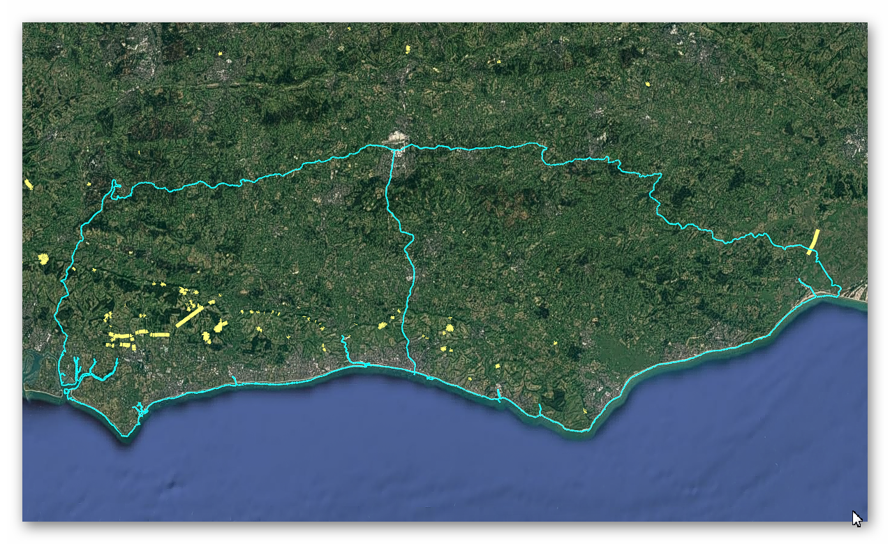
GE Map of Prehistoric Sussex Canals (Dykes)

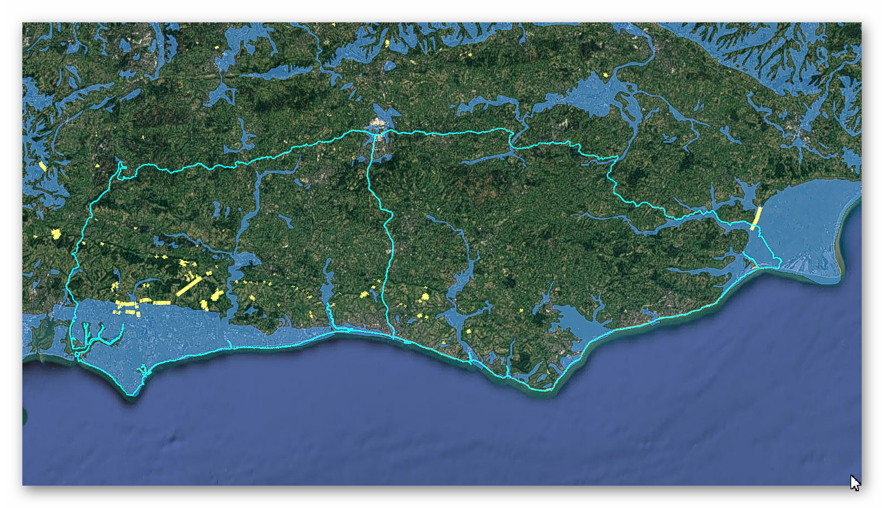
Old Map

Geological Landscape

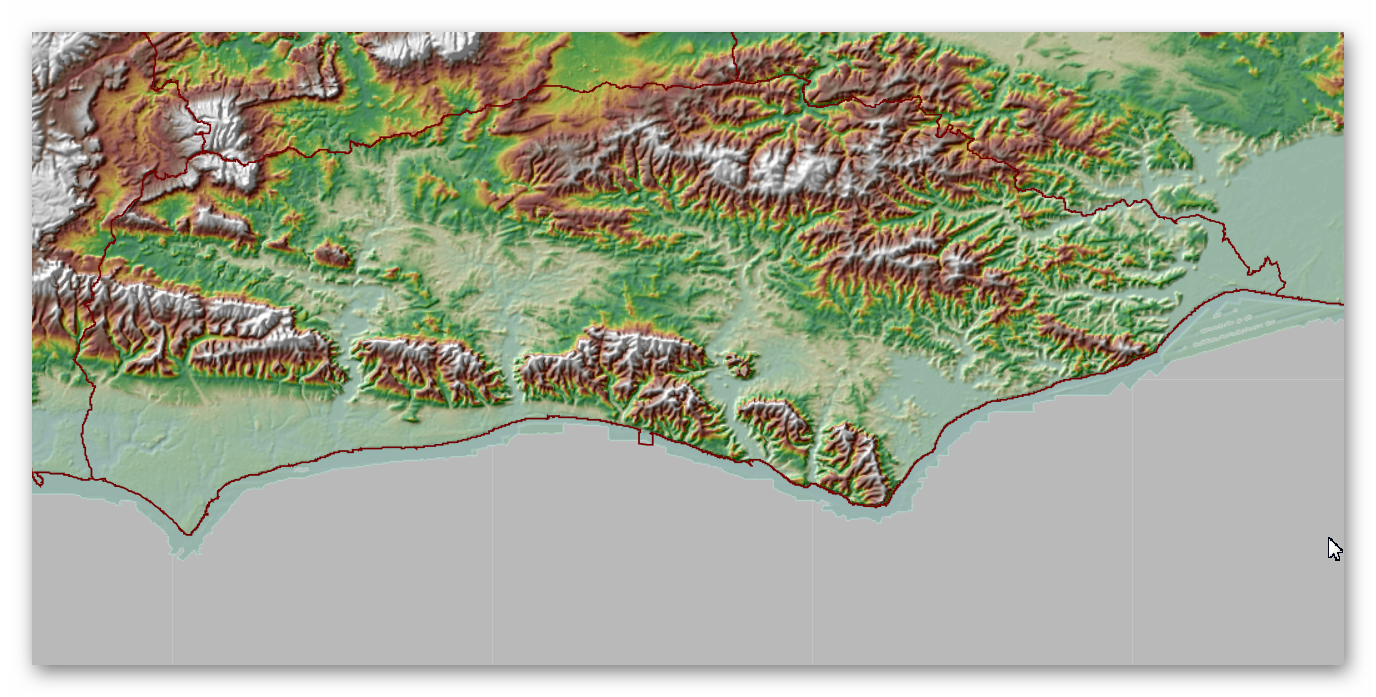
Landscape/Terrain

Database of DYKES (Linear Earthworks) in Sussex
(Click the ‘HE Entry Ref: Number’ (if blue) for more details and Maps)
| Name | HE Entry Ref: | NGF | Length (m) | Overall Width (m) | Ditch Width (m) | Bank Width (m) |
|---|---|---|---|---|---|---|
| Royal Military Canal, Iden Lock to Kent Ditch | 1002216 | TQ 93872 24886 | ||||
| Medieval earthworks at Balmer | 1002241 | TQ 35877 10140 | ||||
| Linear earthwork S of village | 1002262 | TQ3584807520 | ||||
| Earthworks and lynchets on Buckland Bank and Buckland Hole | 1002283 | TQ3708210713 | ||||
| Chichester Dyke, earthwork extending N 360yds (330m) from Otter Memorial College | 1002981 | SU 86415 05960 | ||||
| War Dyke entrenchment in Whiteways Plantation and South Wood | 1002983 | TQ 00451 10478 | ||||
| Madehurst Wood earthworks | 1003736 | SU 97844 08356 | ||||
| Chichester Dyke: section 200yds (180m) long in Mouthey's Plantation, section 245yds (220m) long in Oakwood and section 100yds (90m) long SW of Oakwood House | 1003783 | SU 81983 06569 | ||||
| Chichester Dyke, sections in Little Cotfield Plantation | 1005833 | SU 82990 06436 | ||||
| Cross ridge dykes on Sutton Down | 1005834 | SU 95372 13850 | ||||
| Lynchets N of Downs Farm | 1005836 | TQ 03558 12534 | ||||
| Barrows and ditches on Steyning Round Hill | 1005852 | TQ 16637 10322 | ||||
| Chichester Dyke, Broyle earthwork, section extending 430yds (393m) through East Broyle Copse, to railway, and earthwork extending 400yds (365m) from Brandy Hole Lane, New Fishbourne | 1005853 | SU 85299 06639 | ||||
| Chichester Dyke, Broyle earthwork, section at Brandy Hole, extending E 230yds (210m) from railway, New Fishbourne | 1005854 | SU 85624 06629 | ||||
| Chichester Dyke, section of Broyle earthwork, extending 150yds (140m) through Plain Wood | 1005855 | SU 84974 06655 | ||||
| Chichester Dyke, Broyle earthwork, section extending 360yds (330m) S of West Broyle House | 1005856 | SU 84741 06661 | ||||
| Chichester Dyke, Broyle earthwork, section extending 360yds (330m) SW of Broyle House | 1005857 | SU 84313 06679 | ||||
| Chichester Dyke, earthwork extending 250yds (230m) in Densworth Copse | 1005858 | SU 83204 07545 | ||||
| Chichester Dyke, earthwork extending 300yds (270m) W of Densworth House | 1005859 | SU 82853 07391 | ||||
| Chichester Dyke, earthwork extending 110yds (100m) in Raughmere Copse | 1005860 | SU 85943 08086 | ||||
| Chichester Dyke, earthwork extending N 480yds (440m) from The Drive, Summersdale, near Chichester | 1005861 | SU 86075 07571 | ||||
| Chichester Dyke, earthwork E of Chichester Barracks extending 600yds (550m) | 1005862 | SU 86374 06291 | ||||
| Devil's Ditch, section extending 380yds (350m) NW from The Cottage, Goodwood Park | 1005870 | SU 88321 08868 | ||||
| Devil's Ditch, section extending 330yds (300m) W of Waterbeach Hotel, Goodwood Park, Box Grove | 1005871 | SU 89148 08422 | ||||
| Devil's Ditch, section extending 200yds (180m) E of Waterbeach Hotel, Goodwood Park | 1005872 | SU 89504 08386 | ||||
| Devil's Ditch, section extending 1730yds (1580m) from Stane Street to NW end of Redvin's Copse | 1005873 | SU 89921 08404 | ||||
| Devil's Ditch, section 725yds (660m) long W of Ounces Barn | 1005874 | SU 91642 08469 | ||||
| Devil's Ditch, section extending 1100yds (1000m), Valdoe Wood | 1005875 | SU 87653 08879 | ||||
| Devil's Ditch, section extending 960yds (870m) S of Lavant House | 1005876 | SU 85146 08081 | ||||
| A 210m length of Devil's Ditch running east from Chichester Main Road to Pook Lane | 1005877 | SU 85818 08156 | ||||
| Devil's Ditch, section extending 530yds (480m) W from Lavant Lodge | 1005878 | SU 86824 08664 | ||||
| Devil's Ditch, section extending 1200yds (1100m) through Little Tomlins Copse | 1005879 | SU 84235 07966 | ||||
| Devil's Ditch, section extending 200yds (180m) E from Chapel Lane | 1005880 | SU 83669 07988 | ||||
| A 362m length of Devil's Ditch running WNW from Chapel Lane | 1005881 | SU 83393 08053 | ||||
| Devil's Ditch, section extending 900yds (820m), Lye Wood, West Stoke | 1005882 | SU 82692 08267 | ||||
| Dalesdown Wood earthworks | 1005893 | SU 99769 09708 | ||||
| Goblestubbs Copse earthworks | 1005895 | SU 98406 07504 | ||||
| Cross dyke 730m south east of Ditchling Cross | 1008158 | TQ 36736 12587 | ||||
| Cross dyke and adjacent saucer barrow 850m south east of Ditchling Cross: part of Plumpton Plain round barrow cemetery | 1008159 | TQ 36847 12590 | ||||
| Cross dyke on south eastern spur of Bow Hill, 900m south west of the Tansley Stone | 1008370 | SU 81715 10443 | ||||
| Two bell barrows, two pond barrows and a cross dyke on Bow Hill: part of The Devil's Humps round barrow cemetery | 1008371 | SU 81887 10989 | ||||
| Linear boundary 310m north west of the Tansley Stone on Bow Hill | 1008373 | SU 81986 11279 | ||||
| Cross dyke on northern spur of Bow Hill, 500m north east of the Tansley Stone | 1008374 | SU 82536 11531 | ||||
| Cross dyke on north eastern spur of Bow Hill, 150m south east of the Tansley Stone | 1008379 | SU 82499 11063 | ||||
| Cross dyke on Telscombe Tye | 1009945 | TQ 40250 02959 | ||||
| Hilltop enclosure and linear boundary on Bow Hill | 1012319 | SU 82492 11580 | ||||
| Medieval moated site with flanking ditches and associated fishpond, Claverham Manor | 1012781 | TQ 53684 09034 | ||||
| Cross dyke on Pashley Hill | 1013538 | TV 58800 98294 | ||||
| A cross-ridge dyke and part of an adjoining cross-ridge dyke meeting at Juggs Road near Falmer Bottom | 1013911 | TQ 37081 07322 | ||||
| A prehistoric linear boundary known as Pook's Dyke and the south eastern part of Itford Hill settlement | 1014628 | TQ 44548 05125 | ||||
| Cross dyke on Beachy Brow 30m south east of the golf club | 1014731 | TV 58599 98606 | ||||
| Devil's Dyke hillfort | 1014953 | TQ 25969 11049 | ||||
| Post-medieval stock enclosure at Devil's Dyke | 1014954 | TQ 26574 11237 | ||||
| Cross dyke 420m west of Chanctonbury Ring hillfort | 1015115 | TQ 13514 12040 | ||||
| Cross dyke and platform barrow 460m south east of Chanctonbury Ring hillfort | 1015121 | TQ 14225 11693 | ||||
| Cross dyke and bowl barrow 310m south east of Wolstonbury Camp | 1015226 | TQ 28582 13420 | ||||
| Flint mine and part of a cross dyke 300m south east of Tolmare Farm | 1015237 | TQ 11062 08736 | ||||
| Linear group of three bowl barrows immediately east of Kithurst Hill car park: part of a dispersed round barrow cemetery on Kithurst Hill | 1015709 | TQ 07196 12479 | ||||
| Cross dyke on Chantry Hill, 470m south of Grey Friars Farm | 1015712 | TQ 08436 12636 | ||||
| Cross dyke on Sullington Hill, 500m south east of The Chantry | 1015714 | TQ 09442 12348 | ||||
| Cross dyke on Barpham Hill, 600m north west of Lower Barpham | 1015715 | TQ 06659 09622 | ||||
| Prehistoric linear boundary on Wepham Down | 1015716 | TQ 06263 09936 | ||||
| Cross dyke on Newtimber Hill | 1015717 | TQ 27588 12318 | ||||
| Rackham Banks: A cross dyke and Itford Hill style settlement on Rackham Hill, 900m SSE of Oldbottom Barn | 1015720 | TQ 05059 12540 | ||||
| Cross dyke on Springhead Hill, 780m south of Springhead Farm | 1015723 | TQ 06140 12597 | ||||
| Cross dyke on West Harting Down, 650m south west of Foxcombe Farm | 1015884 | SU 76458 18500 | ||||
| Multiple cross dyke on Harting Downs, 570m east of Down Place | 1015885 | SU 79700 18424 | ||||
| Cross dyke 760m WNW of Pepperscoombe | 1015918 | TQ 16021 10939 | ||||
| Multiple cross dyke on Heyshott Down | 1015958 | SU 89392 16506 | ||||
| Cross dyke 330m north west of Whiteways Lodge | 1015960 | TQ 00204 11019 | ||||
| Prehistoric linear boundary at Crown Tegleaze, 1km north west of Littleton Farm | 1015961 | SU 94317 15152 | ||||
| Prehistoric linear boundary on Barlavington Down, 550m north east of Dog Kennels | 1015962 | SU 96116 15395 | ||||
| Cross dyke on Woolavington Down, 600m south of Lavington House | 1015963 | SU 94656 15732 | ||||
| Cross dyke on Woolavington Down, 625m east of Tegleaze Farm | 1015964 | SU 93906 15588 | ||||
| Cross dyke on Woolavington Down, 475m north east of Tegleaze Farm | 1015965 | SU 93714 16007 | ||||
| Cross dyke on Steyning Round Hill, 700m south west of Pepperscoombe | 1016235 | TQ 16351 10243 | ||||
| Cross dyke 180m north of radio masts at Glatting Beacon | 1016620 | SU 96610 13302 | ||||
| Seven sections of Stane Street Roman road between Eartham and Bignor, a prehistoric linear boundary and two bowl barrows | 1016621 | SU 98873 13958 | ||||
| Cross dyke on Tottington Mount, 550m south east of Tottington Manor Farm | 1016811 | TQ 21792 11089 | ||||
| Heyshott Down round barrow cemetery and cross dykes | 1017614 | SU 90704 16492 | ||||
| Romano-British farmstead 480m north west of Devil's Dyke Cottages | 1017649 | TQ 25573 10669 | ||||
| Cross dyke on St Roche's Hill, 480m north west of The Trundle hillfort | 1018035 | SU 87383 11386 | ||||
| Cross dyke on St Roche's Hill, 410m and 425m north east of The Trundle hillfort | 1018036 | SU 87918 11442 | ||||
| Cross dyke on Heathbarn Down, 520m south east of Lodge Hill Farm | 1018058 | SU 84837 12976 | ||||
| Multiple cross dyke on Little Graffham Bottom, 770m SSW of Hayland Farm | 1018059 | SU 90995 16448 | ||||
| Cross dyke on Upwaltham Hill, 500m and 620m south east of Upwaltham Farm | 1018060 | SU 94645 13334 | ||||
| Double cross dyke on Upwaltham Hill | 1018061 | SU 95104 12766 | ||||
| Linear boundary on Stoke Down, 800m north of West Stoke House | 1018564 | SU 82586 09517 | ||||
| Cross dyke on Steep Down, 600m north east of Titch Hill Farm | 1018565 | TQ 16870 06888 | ||||
| Cross dyke on Steep Down, 700m north east of Beggars Bush | 1018566 | TQ 16655 07570 | ||||
| Cross dyke on Beeding Hill, 1100m north west of New Erringham Farm Cottages | 1018567 | TQ 20745 09130 | ||||
| Cross dyke in Court Plantation, 600m south west of Wiston Barn | 1018568 | TQ 15328 11391 | ||||
| Prehistoric linear boundary and Bronze Age bowl barrow in Pudding Bag Wood, 350m south of Upper Lodges | 1020384 | TQ 32567 09572 | ||||
| Cross dyke in Great Wood, 500m south west of Stanmer House | 1020385 | TQ 33196 09246 |
Dykes Ditches and Earthworks
Indeed, the modern term “dyke” or “dijk” can be traced back to its Dutch origins. As early as the 12th century, the construction of Dykes in the Netherlands was a well-established practice. One remarkable example of their ingenuity is the Westfriese Omringdijk, stretching an impressive 126 kilometres (78 miles), completed by 1250. This Dyke was formed by connecting existing older ‘dykes’, showcasing the Dutch mastery in managing their aquatic landscape.
The Roman chronicler Tacitus even provides an intriguing historical account of the Batavi, a rebellious people who employed a unique defence strategy during the year AD 70. They punctured the Dykes daringly, deliberately flooding their land to thwart their enemies and secure their retreat. This historical incident highlights the vital role Dykes played in the region’s warfare and water management.
Originally, the word “dijk” encompassed both the trench and the bank, signifying a comprehensive understanding of the Dyke’s dual nature – as both a protective barrier and a channel for water control. This multifaceted concept reflects the profound connection between the Dutch people and their battle against the ever-shifting waters that sought to reclaim their land.
The term “dyke” evolved as time passed, and its usage spread beyond the Dutch borders. Today, it represents not only a symbol of the Netherlands’ engineering prowess but also a universal symbol of human determination in the face of the relentless forces of nature. The legacy of these ancient Dykes lives on, a testament to the resilience and innovation of those who shaped the landscape to withstand the unyielding currents of time.
Upon studying archaeology, whether at university or examining detailed ordinance survey maps, one cannot help but encounter peculiar earthworks scattered across the British hillsides. Astonishingly, these enigmatic features often lack a rational explanation for their presence and purpose. Strangely enough, these features are frequently disregarded in academic circles, brushed aside, or provided with flimsy excuses for their existence. The truth is, these earthworks defy comprehension unless we consider overlooked factors at play.
One curious observation revolves around the term “Dyke,” inherently linked to water. It seems rather peculiar to apply such a word to an earthwork atop a hill unless an ancestral history has imparted its actual function through the ages. Let us consider the celebrated “Offa’s Dyke,” renowned for its massive linear structure, meandering along some of the present boundaries between England and Wales. This impressive feat stands as a testament to the past, seemingly demarcating the realms of the Anglian kingdom of Mercia and the Welsh kingdom of Powys during the 8th century.
However, delving further into the evidence and historical accounts challenges this seemingly straightforward explanation. Roman historian Eutropius, in his work “Historiae Romanae Breviarium”, penned around 369 AD, mentions a grand undertaking by Septimius Severus, the Roman Emperor, from 193 AD to 211 AD. In his pursuit of fortifying the conquered British provinces, Severus constructed a formidable wall stretching 133 miles from coast to coast.
Yet, intriguingly, none of the known Roman defences match this precise length. Hadrian’s Wall, renowned for its defensive prowess, spans a mere 70 miles. Could Eutropius have referred to Offa’s Dyke, which bears remarkable similarity to the Roman practice of initially erecting banks and ditches for defence?
For more information click HERE
Further Reading
For information about British Prehistory, visit www.prehistoric-britain.co.uk for the most extensive archaeology blogs and investigations collection, including modern LiDAR reports. This site also includes extracts and articles from the Robert John Langdon Trilogy about Britain in the Prehistoric period, including titles such as The Stonehenge Enigma, Dawn of the Lost Civilisation and the ultimate proof of Post Glacial Flooding and the landscape we see today.
Robert John Langdon has also created a YouTube web channel with over 100 investigations and video documentaries to support his classic trilogy (Prehistoric Britain). He has also released a collection of strange coincidences that he calls ‘13 Things that Don’t Make Sense in History’ and his recent discovery of a lost Stone Avenue at Avebury in Wiltshire called ‘Silbury Avenue – the Lost Stone Avenue’.
Langdon has also produced a series of ‘shorts’, which are extracts from his main body of books:
For active discussions on the findings of the TRILOGY and recent LiDAR investigations that are published on our WEBSITE, you can join our and leave a message or join the debate on our Facebook Group.
