The Durrington Walls Hoax – it’s not a henge?
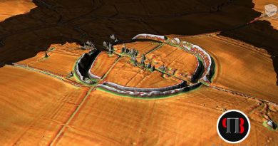
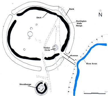
If we look at Durrington Walls (hoax) from top down it looks like a traditional round site which archaeologists call a henge.
But it’s NOT!!
A henge is an earthwork that is created by ditches being cut to produce a corresponding bank – the classic case is Avebury with its massive 12m deep ditches and consequently 12m banks.
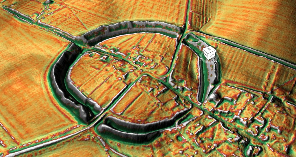
But looking at Durrington Walls from the centre like it has a bank but no visible ditch. Archaeologists suggest that the ditch is under the surface and is not visible although the bank looks massive and one would wonder if you have dug a hole that produces that amount of soil bank then some kind of indentation should be visible – but is not?
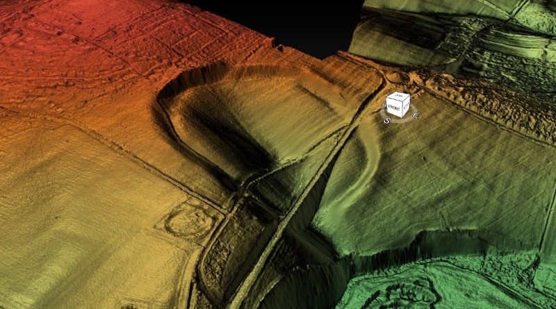
The mystery deepens when you look at Durrington with Lidar which turns it into a 3D model – suddenly this changes its perspective and the round site now transforms into a round hole in the ground with steep walls just like a quarry.
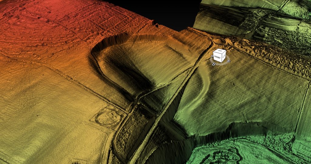
If we look very closely at the outside or back end of the bank looking towards the centre – we find there is no substantial bank… so small it not worth considering as a real bank as the land surround in the site is at the same level.
So why have the archaeologists miss this obvious design flaw and called Durrington Walls a Henge?
If we look at some of their diagrams of the site we find that not only are the ditches hidden from view but also it seems the banks which have been marked on the site maps but are invisible from view.
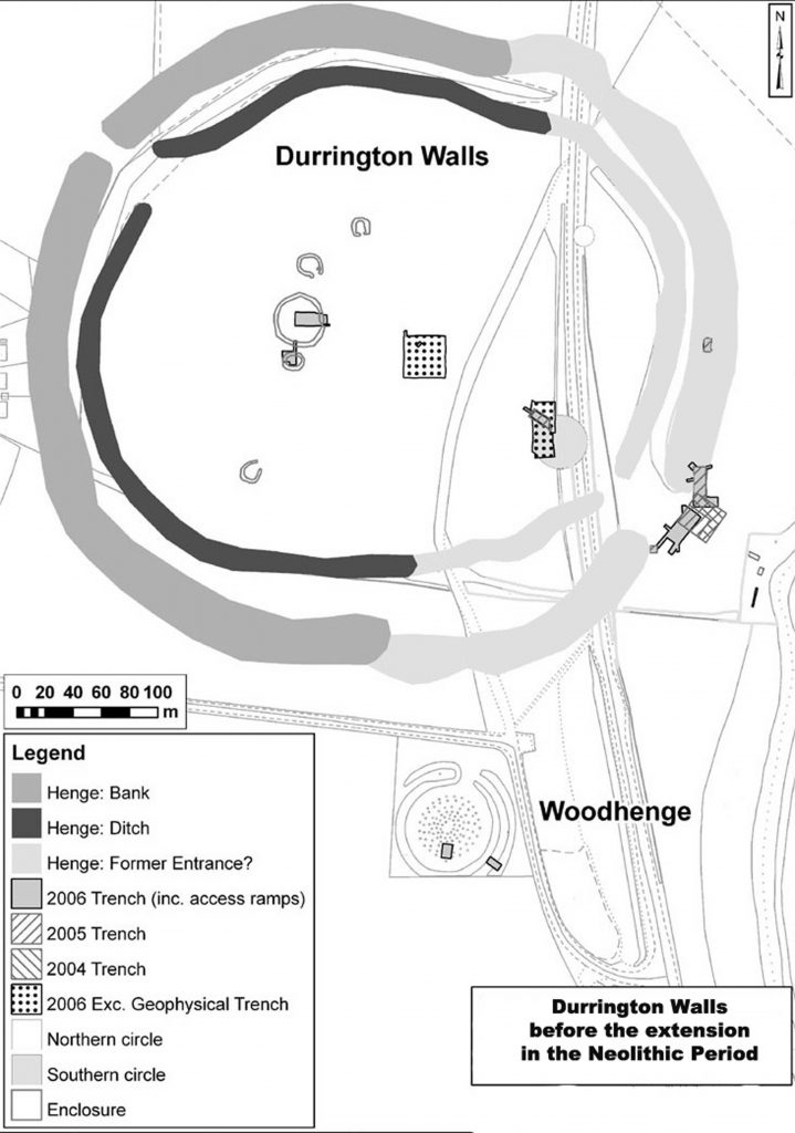
So are the archaeologists relying on detailed excavation evidence then of these ditches and banks – well no, all they have is geophysics guestimations and very limited small excavation results which show that there ‘maybe’ ditches and banks under the ground of unknown proportions.
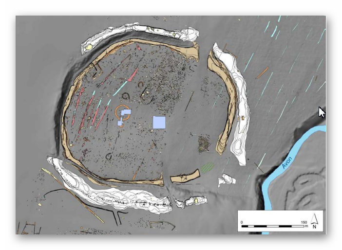
Back to our Lidar map – we can see that this massive carved hole in the landscape is at a strange angle – in fact it tilts towards the River Avon and would have flooded in the past at the start of the Mesolithic when the River Avon was at its highest.
Moreover, if we use LiDAR we can see this strange earthwork is duplicated towards the River Avon – the same kind of steep walls have been cut from the waters of the river. This is were LiDAR is an exceptional tool for landscape archaeology and has not been fully utilised to its full potential when investigation Durrington Walls.
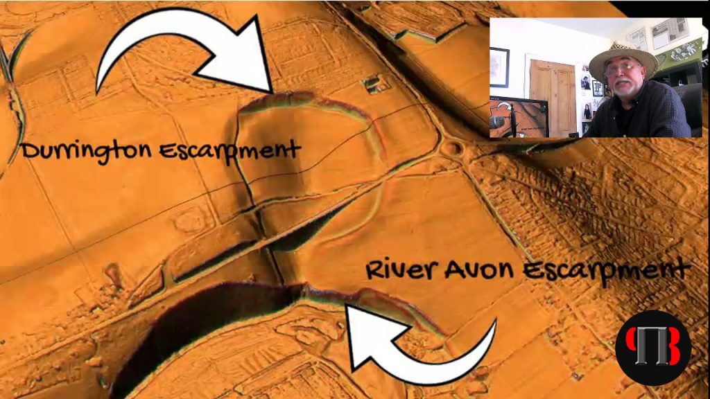
Examining the river-cut cliff face, we notice the extreme height the river had to be in the past, to remove the chalk bedrock. This is another clear indication and proof of the Post-Glacial Flooding that existed after the last ice age and during the Mesolithic period, obviously eroding these cliffs for thousands of years because of the raised river Avon level.
If we know raise the level of the River Avon we see that this feature floods to create a perfect harbour, which would suggest it was natural to start and was tinkered with at a later date as the river levels dropped.
Archaeologists have found ‘natural springs’ withing the site at the north end of the henge which would suggest that it would have flooded with up to 2800 litres of water per second per spring directly at the start of the Mesolithic gradually decreasing the flow over the following millenniums.
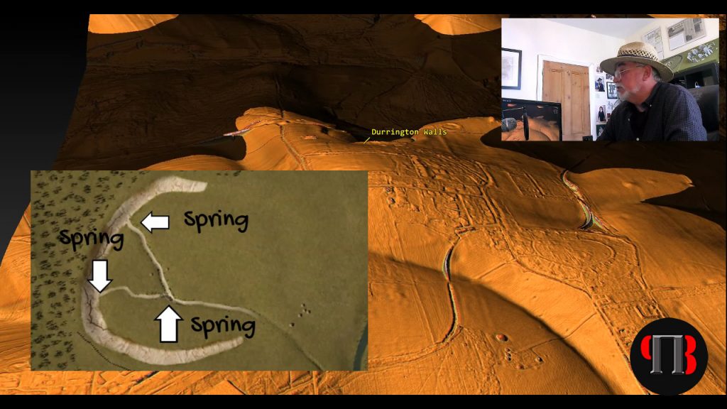
This may explain the shallow ditch found by archaeologists at the northern end which may have been built to allow boats from the river to be ‘beached’ on the shoreline at low tide – and yes the Avon is tidal and even more so in the past as water levels were higher and so the current two metre variation would have been even greater.
Before I continue I feel that I must point out that the current archaeologist believe that Durrington was a settlement for the builders of Stonehenge as they have found post holes in a round patterns within the site. But just looking at the profile of the site clearly shows that to build houses at ground level on this site would be complete ‘bonkers’ – the gradient of the site would flood any house every time it rained and why build a house in a ditch when surround this site is normal flat ground – it’s a sad nonsense.
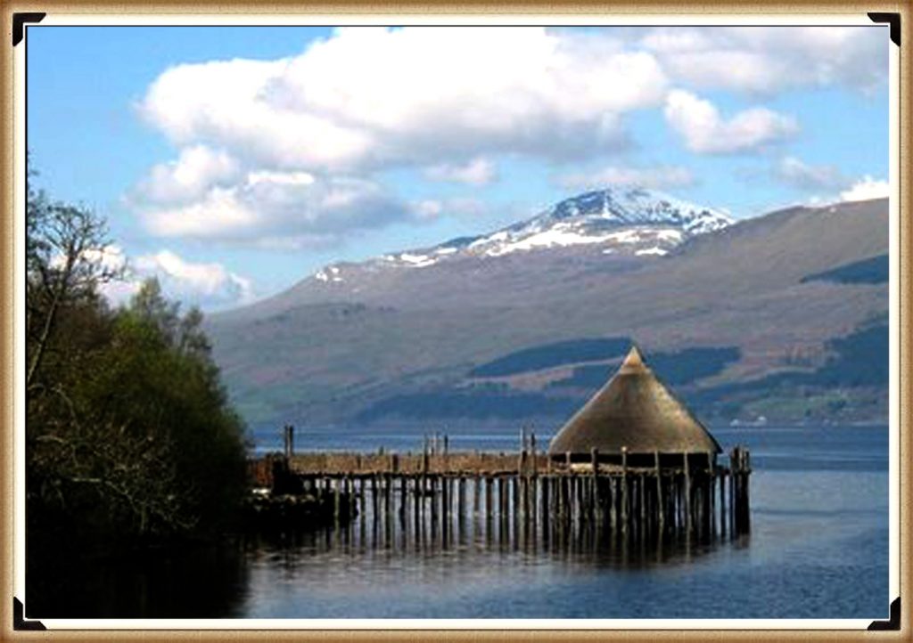
The holes they found were for another kind a building we see in other parts of Britain – a crannog. Crannogs are houses build in the air on stilts in flooded areas as they are perfect mooring sites for boats.
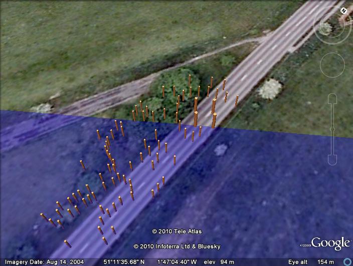
This marine use of this site is further found towards the Eastern side towards the river were we find mooring post similar to what we have seen on the Stonehenge avenue, placed their during the Neolithic period as the water levels fell, with the addition of larger crannogs which archaeologist have misidentified as smaller wooden ceremonial circles.
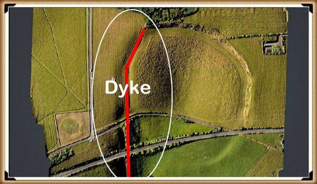
Other additions to the site can be found on the western side of the henge with another feature that has foxed archaeologists and has been misidentified as a lynchet (a farming feature) – this earthwork is a ‘Dyke’ also known as a linear earthwork. It is a ditch and a bank and LiDAR clearly shows it starting from the River Avon.
Sadly, again archaeologists are unaware of why these Dykes were built in the past (which is strange) as there are over 1500+ known scheduled monuments listed as ‘linear Earthworks’ and therefore the most frequent prehistoric feature in the landscape?
My other site investigations have found that Dykes are late Mesolithic and early Neolithic (about 5000 BCE) and so would have been added to the site as an access point once the rive Avon had dropped below the natural harbour entrance to allow boats to access the site up to the ditches in the north of the site we saw earlier.
This is when the Eastern Banks and ditch must have been added to the site – which are clearly shown as very different to the other features on the site. Again it may have been another attempt to prolong the sites usefulness by adding additional landing points as the river shrunk in size.
The biggest question for me is what was this site used for?
In the next video we will look at the famous site connected with Durrington – Woodhenge and why it was constructed and the reason it reinforces the hypothesis that it was a harbour for boats – but where were they going?
A tantalising clue maybe found if we go back to the Dyke that crosses the site going north. If we look closely at lidar we find it actually goes beyond the edge of the site and connects to an existing road at a very odd angle – in fact to road is a dead end going south and so has no reason to kink like it does.
We have found that some B-roads were initially formed from the banks of Dykes and so logically this road could be the direction of the Dyke’s bank that takes us into the middle of the Army camp – which may have been something once but not anymore – sadly we may never know consequently?
Further Reading
For information about British Prehistory, visit www.prehistoric-britain.co.uk for the most extensive archaeology blogs and investigations collection, including modern LiDAR reports. This site also includes extracts and articles from the Robert John Langdon Trilogy about Britain in the Prehistoric period, including titles such as The Stonehenge Enigma, Dawn of the Lost Civilisation and the ultimate proof of Post Glacial Flooding and the landscape we see today.
Robert John Langdon has also created a YouTube web channel with over 100 investigations and video documentaries to support his classic trilogy (Prehistoric Britain). He has also released a collection of strange coincidences that he calls ‘13 Things that Don’t Make Sense in History’ and his recent discovery of a lost Stone Avenue at Avebury in Wiltshire called ‘Silbury Avenue – the Lost Stone Avenue’.
Langdon has also produced a series of ‘shorts’, which are extracts from his main body of books:
For active discussions on the findings of the TRILOGY and recent LiDAR investigations that are published on our WEBSITE, you can join our and leave a message or join the debate on our Facebook Group.

