Great Chesters Roman Aqueduct – Debunked (Part One)
NB. for more detailed LiDAR maps in hi-resolution with zoom facility see the corresponding ‘flip book’ in our online library (Great Chesters Roman Aqueduct – Debunked (Part One))
An aqueduct is an artificial channel used to carry water. All known Roman aqueducts functioned on a gravity flow principle, whereby a water source was impounded at a higher level than the place to be supplied, and was then made to flow to it under the influence of gravity. Water was needed for domestic purposes including bathing and drainage, and also for some industrial processes.
Three main types were built; pipeline aqueducts carried water through enclosed pipework which was normally ceramic, lead or wooden. Channel aqueducts carried water in U-shaped channels, normally a wooden or stone duct, which was either open or covered by stone flags. Leats were the simplest form of aqueduct, and carried water in an open channel dug into the ground and generally lined with clay. They often extended for several kilometres following contour levels. Bridges or other forms of support were used to carry the aqueduct over ravines and uneven terrain such as streams or rivers. The earliest aqueducts date from the period immediately following the Roman Conquest of Britain.
These early examples are associated almost exclusively with military activity and provided water to forts. By the end of the 2nd century, most forts and also public towns had been provided with aqueducts, the need for water being driven particularly by the construction of elaborate bath houses, and the developing fashion of bathing as a social activity amongst both the military and civilian populations. Aqueducts were used throughout the Roman period, and some were still functioning into the 5th century AD. They were found throughout Roman Britain with particular concentrations along Hadrian’s Wall. Only 60 have now been identified to survive. As a rare monument type which provides an important insight into Roman engineering skills and both military and civilian life, all surviving examples are identified to be nationally important.
The Great Chesters Aqueduct
According to Historic Britain’s scheduling details: “The monument includes the remains of an aqueduct of Roman date, which carried water from Caw Burn westwards to Great Chesters Roman fort. The aqueduct adopts a circuitous route closely following the topography of the landscape. The protected portions of the monument are contained within five separate areas of protection, which stretch over approximately 8.68km of the aqueduct’s length. The aqueduct is preserved as a partial earthwork and in other locations as a cropmark.” – doesn’t tell us much really?
Sadly It’s all very loose with no excavations just a few field walkers to verify the aqueduct – if it is a aqueduct that is?
Great Chesters Roman Aqueduct (NY741688 to NY703668) – according to the book NORTH-EAST HISTORY TOUR
“One of the neatest feats of Roman engineering in the region is one of the least known. It is the 9.5km line of the Roman aqueduct leading into the old fort of Great Chesters from the NE, a little to the north of Haltwhistle.
Only very faint traces of it remain today, but the logistics of the little water supply project are impressive. Basically, when Great Chesters fort was built on the Wall it didn’t have a nearby water supply, so it had to be piped in from the Caw Burn, about 4km to the NE (more specifically, Saughy Rigg Washpool near Fond Tom’s Pool). However, as the engineers had to rely purely on gravity, the path of the aqueduct took a long and curling route through a 9km+ course to pick up every tiny inch of downhill along the way.
The result was a remarkable bendy, twisting affair taking the channel on a constantly downward trajectory at the almost unbelievably gentle gradient of about 1m drop for every 1,000m travelled. And, once more, the flow of water was eased along a simple, unlined water-course about ½ m wide by ¼ m deep, with the occasional small wooden bridge inserted to take it over minor valleys and streams.
The course of the aqueduct is clearly shown on modern-day OS maps (there’s a decent representation here – and scroll down a bit), though it is not so easy to pick out on the ground. Partial earthworks survive, and in other places crop marks provide the circumstantial evidence.“
Sadly, this perception of History is typical due to the misunderstanding of the Landscape in the past and the misconception of ‘Linear History’ – technology growth and sophistication from one century to the next – which strangely the Roman empire clearly disproves (ask anyone in the Dark Ages who needed to live in Mud Huts with contaminated food and water supplies?
If we now look at modern methods to look at this feature we see quite clearly the problem with the assumption that this is a Roman Aqueduct.
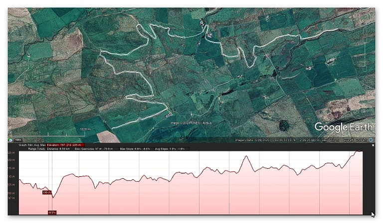
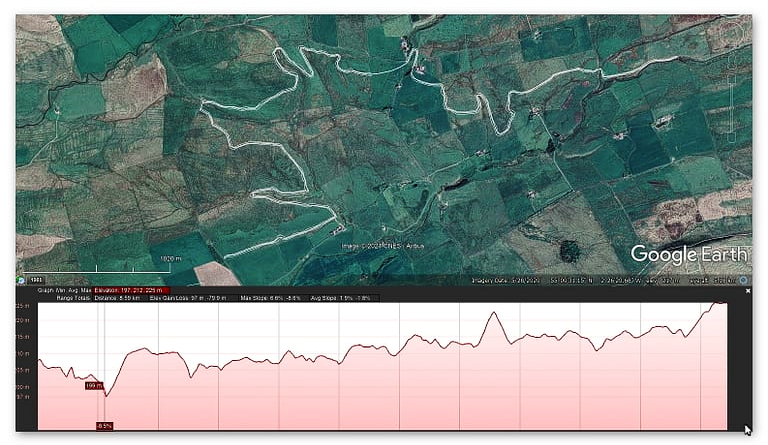
The profile of the alleged aqueduct is not this ” gentle gradient of about 1m drop for every 1,000m travelled ” but a very haphazard path which would need the aqueduct to defy the laws of gravity in many areas. Within this path there are connections to river valleys no less than six times. It has been suggested that ‘wooden’ (as no stone has ever been found was used to bridge the gaps!! What has not been explained is the last leg of this epic journey where the aqueduct goes up hill by 10m over the last 800m of the journey??
Moreover, the Fort has a much closer source of water – in fact several sources of water which makes such an aqueduct irrelevant?
If we ‘reverse engineer’ the water sources of the fort Aesica we can reveal something quite misunderstood.
Aesica – Wikipedia
Aesica (with the modern name of Great Chesters) was a Roman fort, one and a half miles north of the small town of Haltwhistle in Northumberland, England. It was the ninth fort on Hadrian’s Wall, between Vercovicium (Housesteads) to the east and Magnis (Carvoran) to the west. Its purpose was to guard the Caw Gap, where the Haltwhistle Burn crosses the Wall.
It is believed that the fort was completed in the year 128 AD. Unlike other wall forts that project beyond the Wall, all of Aesica is south of the Wall. The Wall at this point is narrow gauge, but stands next to foundations that were prepared for the broad wall. There was speculation as to why the foundations for the broad wall had not been used to support the wall at this point. In 1939 it was found that Milecastle 43 had already been built in preparation for the broad wall, and it is thought that it was the presence of this milecastle that prevented the north wall of the fort being built on the original foundations. It appears that the milecastle was demolished once the fort had been completed. The east gate and east wall cannot now be traced.
The fort was an oblong, measuring 355 feet (108 m) north to south by 419 feet (128 m) east to west, occupying a comparatively small area of 3 acres (12,000 m2). The north-east corner of the fort is now occupied by farm buildings, built over the route of the Wall.
The fort had only three main gates; south, east and west, with double portals with towers. At some time the west gate was completely blocked up. There were towers at each corner of the fort. The Military Way entered by the east gate and left by the west gate. A branch road from the Stanegate entered by the south gate.
The Vallum passed some short distance south of the fort, and was crossed by a road leading from the south gate to the Stanegate. A vicus lay to the south and east of the fort, and several tombstones have been found there.
The fort was supplied by water from an aqueduct, which wound six miles (10 km) from the head of the Haltwhistle Burn, north of the Wall.
So the Great Chesters Aqueduct fed not only the fort but also the Bath House as it was the only source of water in the area?
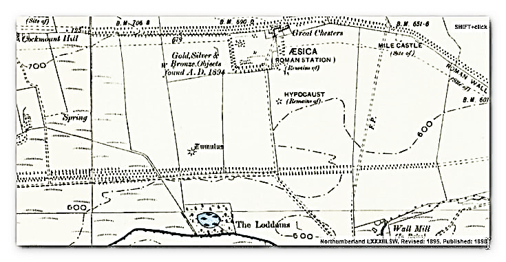
This 1800s map shows the Great Chesters Fort (Aesica) and the bath house south of the Fort – it also indicates a path for an Aqueduct going south to the Vallum and then to the river. This shows the water travelling down hill from 208m high at the Fort to 180m at the river – this is clearly the OUTLET of the water.
The Lidar map shows this much better but moreover, it also shows that the outlet is NOT the river but the Vallum.
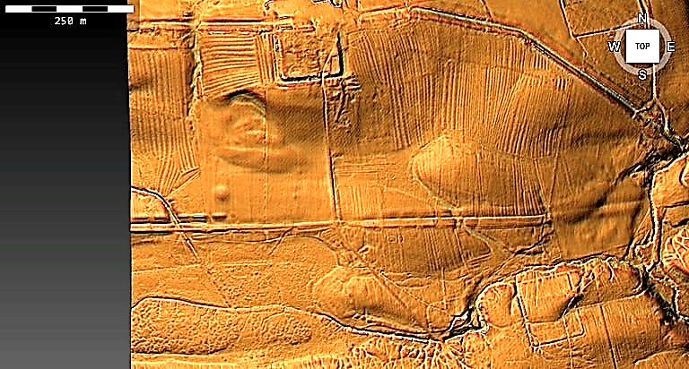
So is the Great Chesters Aqueduct (all 9km) connected to this point in the Fort?
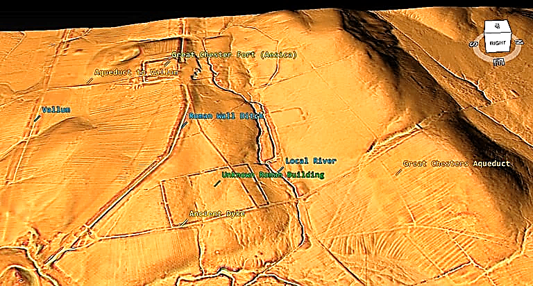
The Great Chesters Aqueduct is too far from the fort to connect and there is not sign of anything on Lidar? What LiDAR suggests is that a Dyke connects the local river to the Wall Ditch and that the Wall ditch is so deep it also was below the water table making it a moat.
Looking at the other side of this ditch/moat – we see that there is a break in the wall that may have allowed water to feed the moat/ditch via another ancient dyke?
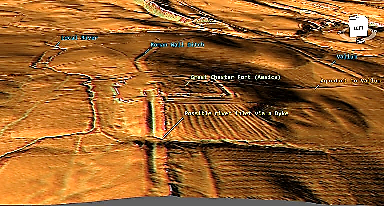
This connection seems to be in agreement with excavations of Aesica which shows the ‘aqueduct’ going through the centre of the fort.
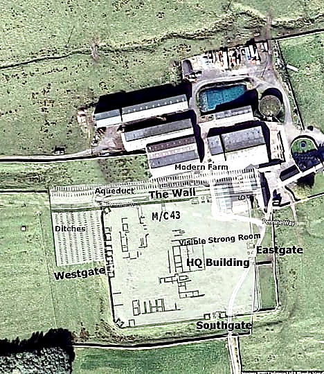
So if the Great Chesters Aqueduct is not a 9km Roman piece of engineering – what are we seeing in the Landscape?
LiDAR Investigation starting North East of the Fort – Section One
We will look at each section in turn to see if it actually existed and whether it would flow as expected or that it has another more feasible explanation. The start of the Aqueduct we will call section 1 it is by the River Caw Burn (which flows from Right to Left) and flows the river for a while (Fig. 1 – top right corner) without reason or any ditch found on LiDAR.
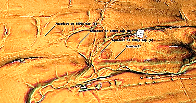
To connect to the river before (C) in the suggested route would not make much sense as the river runs along side and it would need to fight against gravity (as section C is two metres higher than A) it could connect up better to section (A) via the stream running past section (A) to the right much more effectively (unless it was dry during this period). What is more interesting and missed by the archaeologists is the man-made Dyke that cuts North – South between Section B and C connecting the stream to the river with banks on both sides – the southern half is now dry and used as a footpath, but LiDAR clearly shows at one time it went directly from the prehistoric stream.
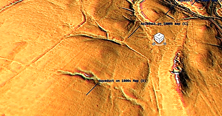
Section two shows that the Aqueduct goes from 4m wide in (C) to 1m wide in (D) over a very small length? Moreover, again LiDAR suggests that at (C) this 4m ditch connects to another Palaeochannel (that would have held water in prehistory) and then seems to head South of (D) to get another palaeochannel keeping the 4m width.
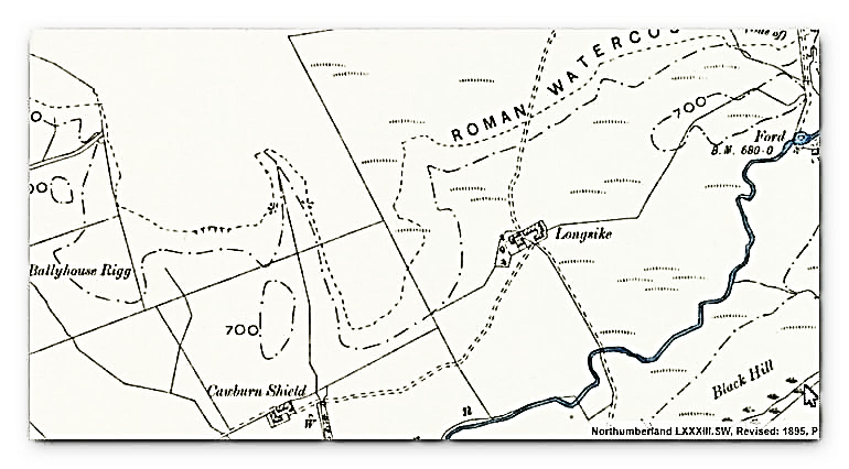
Section 3 goes on a ‘merry dance’ around the landscape without good evidence or reason. The OS map suggests that the route south then north is not required as you could just continue on the same line, which is confirmed on the LiDAR map.
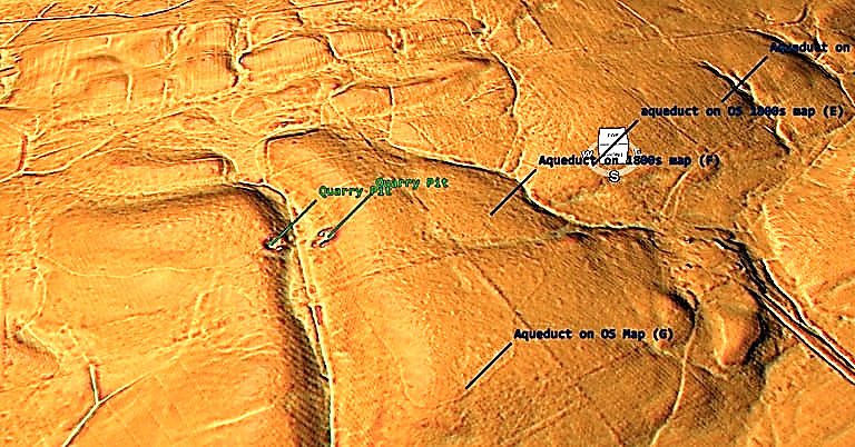
Closure inspection would suggest that (E) terminates in the Palaeochannel and (F) is a linear feature that continues past the palaeochannel and does not connect to the suggested aqueduct.
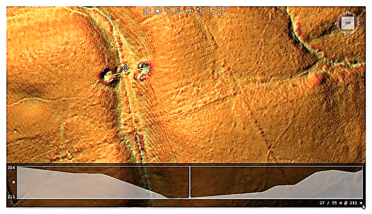
Section 4 shows that the aqueduct stops at the quarry and starts again on the quarry opposite and does not go around or through the valley as suggested on the OS maps – but what it does open up is the possibility that a stonebridge once connected the aqueduct which has been robbed out?? as it is 50m wide and of the same altitude with a slight slope right to left.
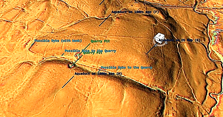
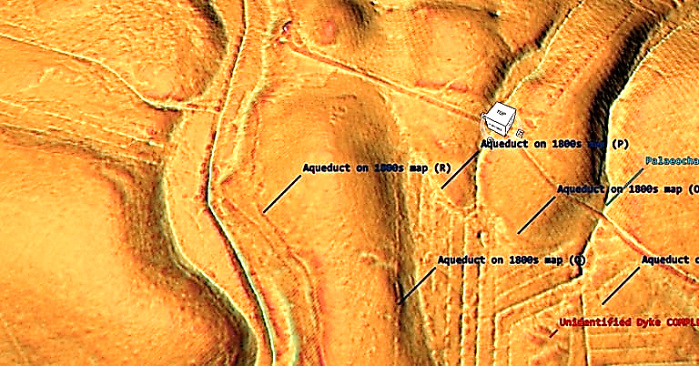
If the quarry pits are not the foundations of a stone bridge – then these quarry pits do seems to have Dykes connecting them the the palaeochannel. What there clearly is not is a continuation of the Aquaduct north of each pit. The ditch on section (H) is again quite pronounced at 2m in width – which is more than adequate for ample water is somewhat overkill as some regions is only 1m wide and so is wasted over engineering?.
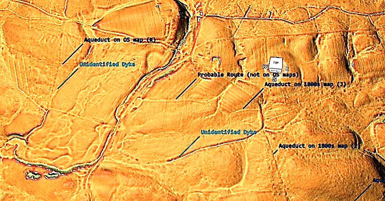
The aqueduct in area (J) seems to connect to another unidentified Dyke of much larger specification (8m wide with Bank) before turning West and on the OS map moving north to the settlement of Edges Green and crossing the river (via a bridge??) but LiDAR sees no evidence of this suggested route. What we do see (but missed by archaeologists) that the route goes west to the palaeochannel, only to reappear out of another Palaeochannel to the West (K).
Moreover, the LiDAR map shows two more possible Dykes – the one on the East side 8m width with 4m ditch and bank and the one on the East 10m wide with a 5m bank and ditch.
End of Part One – Part Two to be published next week.
For more information about Linear Earthworks (Dykes) see our other BLOG POSTS or our LiDAR Investigations on our YOUTUBE channel.
Further Reading
For information about British Prehistory, visit www.prehistoric-britain.co.uk for the most extensive archaeology blogs and investigations collection, including modern LiDAR reports. This site also includes extracts and articles from the Robert John Langdon Trilogy about Britain in the Prehistoric period, including titles such as The Stonehenge Enigma, Dawn of the Lost Civilisation and the ultimate proof of Post Glacial Flooding and the landscape we see today.
Robert John Langdon has also created a YouTube web channel with over 100 investigations and video documentaries to support his classic trilogy (Prehistoric Britain). He has also released a collection of strange coincidences that he calls ‘13 Things that Don’t Make Sense in History’ and his recent discovery of a lost Stone Avenue at Avebury in Wiltshire called ‘Silbury Avenue – the Lost Stone Avenue’.
Langdon has also produced a series of ‘shorts’, which are extracts from his main body of books:
For active discussions on the findings of the TRILOGY and recent LiDAR investigations that are published on our WEBSITE, you can join our and leave a message or join the debate on our Facebook Group.



Pingback: Great Chesters (Roman) Aqueduct (Part Two) - Prehistoric Britain
Pingback: Section K - NY76NW - Prehistoric Britain