Wansdyke LiDAR Flyover
Promotional video for the book transcript………………………….. Ancient prehistoric Canals (Dykes) – Wansdyke
Contents
- 1 Introduction
- 2 Wansdyke
- 2.1 The Eastern Start of Wansdyke
- 2.2 The Role of LiDAR in Revealing Wansdyke’s History
- 2.3 Gaps and Deviations in Wansdyke’s Structure
- 2.4 Connections to Other Features
- 2.5 Later Modifications and Roman Influence
- 2.6 Wansdyke as a Window Into Prehistoric Innovation
- 2.7 Implications for Archaeological Methods
- 2.8 A Legacy of Adaptation and Innovation
- 3 Exploring Prehistoric Britain: A Journey Through Time
- 4 Further Reading
- 5 Other Blogs
Introduction
Wansdyke
Archaeologists and historians have proposed numerous theories regarding dykes such as Wansdyke. Initially, they believed it served as a defensive structure to protect territories from hostile tribes. However, more recent theories, influenced by the absence of evidence such as human remains from excavations, suggest it functioned as a border marker. This border hypothesis, however, can be challenged by examining the easternmost section of Wansdyke.
The Eastern Start of Wansdyke
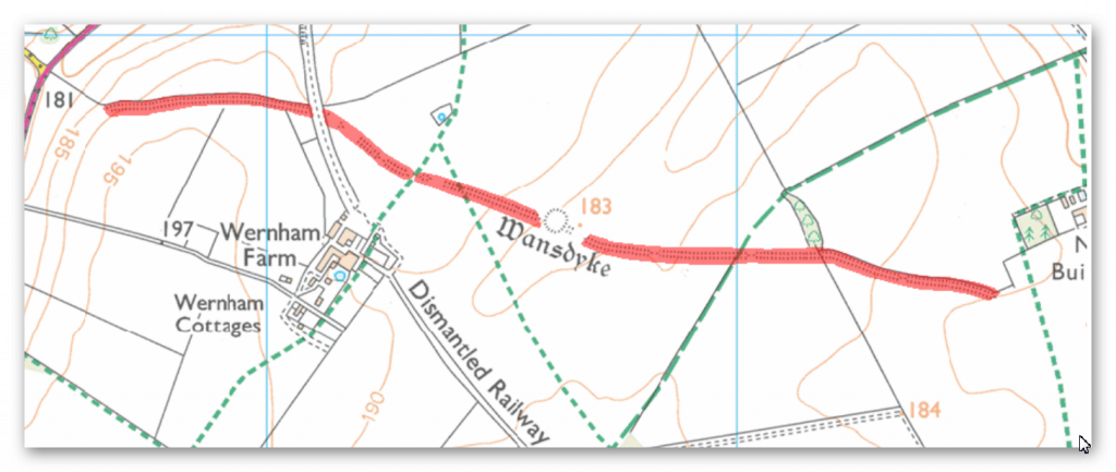
To understand Wansdyke’s purpose, we must first consider how it might have appeared in prehistory when river levels were significantly higher than today. Research involving over 1,500 dykes in England suggests that fluctuating groundwater levels during the Mesolithic and Neolithic periods (5,000–10,000 years ago) drastically altered the landscape. This environmental context sheds light on the mysterious beginning of Wansdyke, which lies in an unassuming field.
This starting point poses a conundrum. If Wansdyke were a defensive structure, invaders could simply bypass it. Similarly, as a border marker, it appears illogical, given the seemingly arbitrary placement in what would have been “no man’s land” to the east. However, when we consider the Mesolithic water levels, this puzzle begins to make sense. At that time, the eastern end of Wansdyke likely met the shoreline of the River Kennet, acting as an artificial canal that extended across a water-covered landscape.
The Role of LiDAR in Revealing Wansdyke’s History
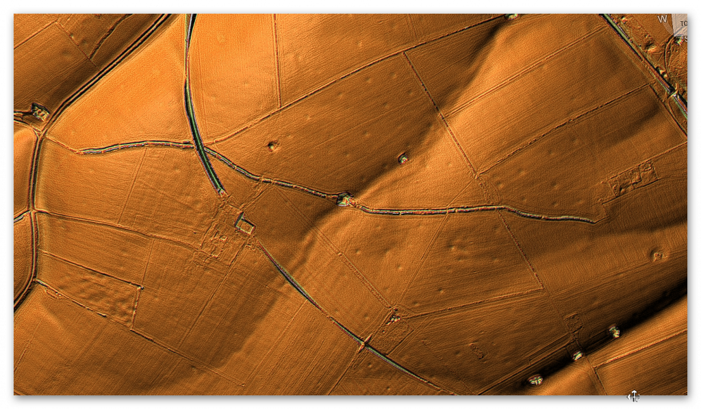
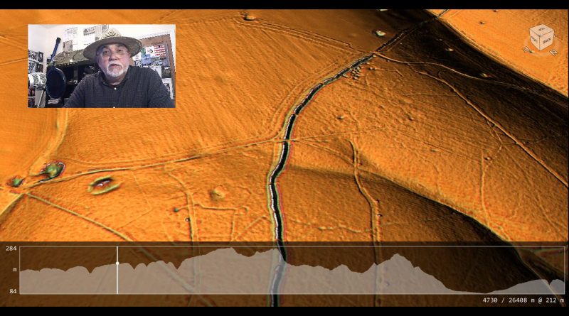
Using LiDAR technology, we can explore Wansdyke’s alignment with ancient water levels and examine its potential origins. Early in this examination, we observe a cluster of pits and quarries surrounding the dyke. These features suggest that the initial purpose of Wansdyke might have been related to resource extraction. Unfortunately, these pits remain largely unexcavated, leaving their significance and contents a mystery.
One particularly large quarry lies directly within Wansdyke itself. This raises questions: was it used for material extraction, or was it later adapted to access lower water levels, possibly during the Roman period when Wansdyke may have been repurposed?
Gaps and Deviations in Wansdyke’s Structure
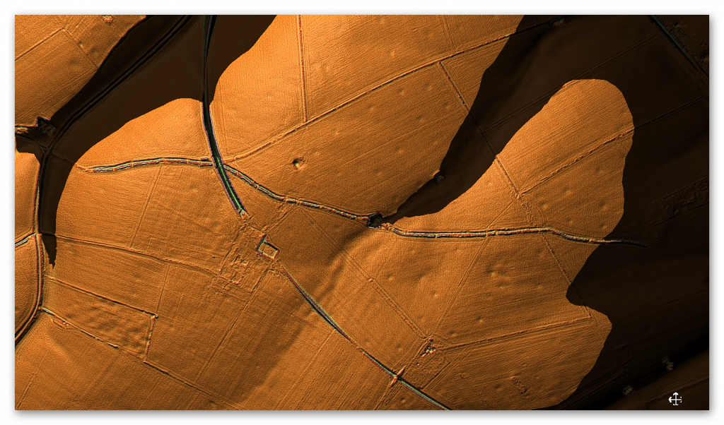
Several gaps in Wansdyke also align with prehistoric waterlines. For example, LiDAR reveals the trace of a palaeochannel (a remnant of an ancient river) that aligns with one such gap. These interruptions suggest that Wansdyke may have originally followed natural watercourses, with later modifications to connect separate segments.
Another perplexing feature is a 90-degree bend in the dyke’s course. This sharp turn would have required substantial extra labour and makes little sense for a defensive structure or border marker. However, if we consider the Mesolithic landscape, this bend corresponds to a shoreline, indicating that Wansdyke likely extended across the river, aligning with natural contours of the water.
Connections to Other Features

Throughout Wansdyke, we see evidence of connections to other prehistoric features. A nearby long barrow, for instance, appears to have been positioned along the edge of a palaeochannel, hinting at the relationship between these earthworks and ancient water levels. Other cross-dykes, tumuli, and barrows scattered along Wansdyke further suggest a complex, evolving use of the landscape over time.
Interestingly, LiDAR reveals a potential square building over Wansdyke that does not appear on modern maps. Its characteristics suggest Roman origins, further evidence that the Romans adapted Wansdyke for their purposes.
Later Modifications and Roman Influence
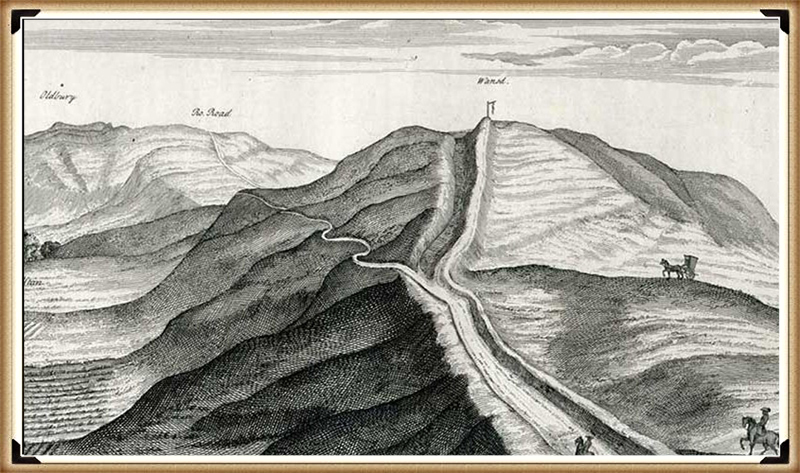
In some sections, Wansdyke appears as a straight line, which contrasts with its otherwise irregular path. This straight alignment may reflect Roman engineering, as it parallels their known preference for direct routes. For instance, one stretch aligns with a Roman road, and closer inspection reveals that the road was constructed within the existing dyke’s ditch. This configuration strongly implies that Wansdyke predated the Roman road.
Historical sketches by William Stukeley in 1724 provide additional evidence, showing the Roman road cutting through Wansdyke’s embankment. This supports the argument that Wansdyke originated in prehistoric times when higher river levels would have rendered it part of a broader canal network.
Wansdyke as a Window Into Prehistoric Innovation

The idea of Wansdyke as a canal rather than a defensive or territorial feature raises intriguing questions about the ingenuity of prehistoric communities. The ability to manipulate natural waterways and integrate them with constructed earthworks demonstrates a sophisticated understanding of engineering and environmental management. Such systems would have been vital for trade, resource transportation, and sustaining settlements in an era defined by dynamic landscapes.
If Wansdyke truly functioned as part of a prehistoric canal system, it challenges traditional narratives that often downplay the complexity of Mesolithic and Neolithic societies. This perspective not only underscores the advanced capabilities of these ancient communities but also invites a re-evaluation of similar features across Britain and beyond. How many other “defensive dykes” might share this hidden history?
Implications for Archaeological Methods

The case of Wansdyke highlights the limitations of conventional archaeological approaches. Current reliance on surface-level excavations and isolated carbon dating often fails to capture the broader environmental and historical context of such structures. As demonstrated here, integrating technologies like LiDAR with hydrological and geological studies can provide transformative insights. It also emphasises the need for a multidisciplinary approach to interpreting ancient landscapes.
The neglect of quarry features around Wansdyke, for example, represents a missed opportunity to understand the resources and techniques available to its builders. Future investigations that incorporate more detailed excavation and modern technologies could yield a wealth of data to refine our understanding of Britain’s prehistoric engineering marvels.
A Legacy of Adaptation and Innovation
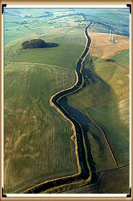
Wansdyke’s story is one of adaptation. From its hypothesised origins as a Mesolithic canal to later modifications by Roman and possibly Saxon cultures, the dyke exemplifies how ancient peoples repurposed and transformed existing structures to meet evolving needs. Whether as a waterway, resource hub, or trade route, Wansdyke stands as a testament to humanity’s ability to innovate and endure across millennia.
By situating Wansdyke within the broader prehistoric context, we move closer to understanding its original purpose and the sophisticated societies that shaped Britain’s ancient landscapes. Its winding paths, mysterious interruptions, and enduring presence remind us that history is not static but a tapestry woven from the ingenuity and adaptability of countless generations.
Exploring Prehistoric Britain: A Journey Through Time
My blog delves into the fascinating mysteries of prehistoric Britain, challenging conventional narratives and offering fresh perspectives based on cutting-edge research, particularly using LiDAR technology. I invite you to explore some key areas of my research. For example, the Wansdyke, often cited as a defensive structure, is re-examined in light of new evidence. I’ve presented my findings in my blog post Wansdyke: A British Frontier Wall – ‘Debunked’, and a Wansdyke LiDAR Flyover video further visualizes my conclusions.
My work also often challenges established archaeological dogma. I argue that many sites, such as Hambledon Hill, commonly identified as Iron Age hillforts are not what they seem. My posts Lidar Investigation Hambledon Hill – NOT an ‘Iron Age Fort’ and Unmasking the “Iron Age Hillfort” Myth explore these ideas in detail and offer an alternative view. Similarly, sites like Cissbury Ring and White Sheet Camp, also receive a re-evaluation based on LiDAR analysis in my posts Lidar Investigation Cissbury Ring through time and Lidar Investigation White Sheet Camp, revealing fascinating insights into their true purpose. I have also examined South Cadbury Castle, often linked to the mythical Camelot56.
My research also extends to the topic of ancient water management, including the role of canals and other linear earthworks. I have discussed the true origins of Car Dyke in multiple posts including Car Dyke – ABC News PodCast and Lidar Investigation Car Dyke – North Section, suggesting a Mesolithic origin2357. I also explore the misidentification of Roman aqueducts, as seen in my posts on the Great Chesters (Roman) Aqueduct. My research has also been greatly informed by my post-glacial flooding hypothesis which has helped to inform the landscape transformations over time. I have discussed this hypothesis in several posts including AI now supports my Post-Glacial Flooding Hypothesis and Exploring Britain’s Flooded Past: A Personal Journey
Finally, my blog also investigates prehistoric burial practices, as seen in Prehistoric Burial Practices of Britain and explores the mystery of Pillow Mounds, often mistaken for medieval rabbit warrens, but with a potential link to Bronze Age cremation in my posts: Pillow Mounds: A Bronze Age Legacy of Cremation? and The Mystery of Pillow Mounds: Are They Really Medieval Rabbit Warrens?. My research also includes the astronomical insights of ancient sites, for example, in Rediscovering the Winter Solstice: The Original Winter Festival. I also review new information about the construction of Stonehenge in The Stonehenge Enigma
Further Reading
For those interested in British Prehistory, visit www.prehistoric-britain.co.uk, a comprehensive resource featuring an extensive collection of archaeology articles, modern LiDAR investigations, and groundbreaking research. The site also includes insights and extracts from the acclaimed Robert John Langdon Trilogy, a series of books exploring Britain during the Prehistoric period. Titles in the trilogy include The Stonehenge Enigma, Dawn of the Lost Civilisation, and The Post Glacial Flooding Hypothesis, offering compelling evidence about ancient landscapes shaped by post-glacial flooding.
To further explore these topics, Robert John Langdon has developed a dedicated YouTube channel featuring over 100 video documentaries and investigations that complement the trilogy. Notable discoveries and studies showcased on the channel include 13 Things that Don’t Make Sense in History and the revelation of Silbury Avenue – The Lost Stone Avenue, a rediscovered prehistoric feature at Avebury, Wiltshire.
In addition to his main works, Langdon has released a series of shorter, accessible publications, ideal for readers delving into specific topics. These include:
- The Ancient Mariners
- Stonehenge Built 8300 BCE
- Old Sarum
- Prehistoric Rivers
- Dykes, Ditches, and Earthworks
- Echoes of Atlantis
- Homo Superior
- 13 Things that Don’t Make Sense in History
- Silbury Avenue – The Lost Stone Avenue
- Offa’s Dyke
- The Stonehenge Enigma
- The Post-Glacial Flooding Hypothesis
- The Stonehenge Hoax
- Dawn of the Lost Civilisation
- Darwin’s Children
- Great Chester’s Roman Aqueduct
- Wansdyke
For active discussions and updates on the trilogy’s findings and recent LiDAR investigations, join our vibrant community on Facebook. Engage with like-minded enthusiasts by leaving a message or contributing to debates in our Facebook Group.
Whether through the books, the website, or interactive videos, we aim to provide a deeper understanding of Britain’s fascinating prehistoric past. We encourage you to explore these resources and uncover the mysteries of ancient landscapes through the lens of modern archaeology.
For more information, including chapter extracts and related publications, visit the Robert John Langdon Author Page. Dive into works such as The Stonehenge Enigma or Dawn of the Lost Civilisation, and explore cutting-edge theories that challenge traditional historical narratives.
Other Blogs
1
a
- AI now Supports – Homo Superior
- AI now supports my Post-Glacial Flooding Hypothesis
- Alexander the Great sailed into India – where no rivers exist today
- Ancient Prehistoric Canals – The Vallum
- Ancient Secrets of Althorp – debunked
- Antler Picks built Ancient Monuments – yet there is no real evidence
- Antonine Wall – Prehistoric Canals (Dykes)
- Archaeological ‘pulp fiction’ – has archaeology turned from science?
- Archaeological Pseudoscience
- Archaeology in the Post-Truth Era
- Archaeology: A Bad Science?
- Archaeology: A Harbour for Fantasists?
- Archaeology: Fact or Fiction?
- Archaeology: The Flaws of Peer Review
- Archaeology’s Bayesian Mistake: Stop Averaging the Past
- Are Raised Beaches Archaeological Pseudoscience?
- Atlantis Found: The Mathematical Proof That Plato’s Lost City Was Doggerland
- ATLANTIS: Discovery with Dan Snow Debunked
- Avebury Ditch – Avebury Phase 2
- Avebury Post-Glacial Flooding
- Avebury through time
- Avebury’s great mystery revealed
- Avebury’s Lost Stone Avenue – Flipbook
b
- Battlesbury Hill – Wiltshire
- Beyond Stone and Bone: Rethinking the Megalithic Architects of Northern Europe
- BGS Prehistoric River Map
- Blackhenge: Debunking the Media misinterpretation of the Stonehenge Builders
- Brain capacity (Cro-Magnon Man)
- Brain capacity (Cro-Magnon Man)
- Britain’s First Road – Stonehenge Avenue
- Britain’s Giant Prehistoric Waterways
- British Roman Ports miles away from the coast
c
- Caerfai Promontory Fort – Archaeological Nonsense
- Car Dyke – ABC News PodCast
- Car Dyke – North Section
- CASE STUDY – An Inconvenient TRUTH (Craig Rhos Y Felin)
- Case Study – River Avon
- Case Study – Woodhenge Reconstruction
- Chapter 2 – Craig Rhos-Y-Felin Debunked
- Chapter 2 – Stonehenge Phase I
- Chapter 2 – Variation of the Species
- Chapter 3 – Post Glacial Sea Levels
- Chapter 3 – Stonehenge Phase II
- Chapter 7 – Britain’s Post-Glacial Flooding
- Cissbury Ring through time
- Cro-Magnon Megalithic Builders: Measurement, Biology, and the DNA
- Cro-Magnons – An Explainer
d
- Darwin’s Children – Flipbook
- Darwin’s Children – The Cro-Magnons
- Dawn of the Lost Civilisation – Flipbook
- Dawn of the Lost Civilisation – Introduction
- Digging for Britain – Cerne Abbas 1 of 2
- Digging for Britain Debunked – Cerne Abbas 2
- Digging Up Britain’s Past – Debunked
- DLC Chapter 1 – The Ascent of Man
- Durrington Walls – Woodhenge through time
- Durrington Walls Revisited: Platforms, Fish Traps, and a Managed Mesolithic Landscape
- Dyke Construction – Hydrology 101
- Dykes Ditches and Earthworks
- DYKES of Britain
e
f
g
h
- Hadrian’s Wall – Military Way Hoax
- Hadrian’s Wall – the Stanegate Hoax
- Hadrian’s Wall LiDAR investigation
- Hambledon Hill – NOT an ‘Iron Age Fort’
- Hayling Island Lidar Maps
- Hidden Sources of Ancient Dykes: Tracing Underground Groundwater Fractals
- Historic River Avon
- Hollingsbury Camp Brighton
- Hollows, Sunken Lanes and Palaeochannels
- Homo Superior – Flipbook
- Homo Superior – History’s Giants
- How Lidar will change Archaeology
i
l
m
- Maiden Castle through time
- Mathematics Meets Archaeology: Discovering the Mesolithic Origins of Car Dyke
- Mesolithic River Avon
- Mesolithic Stonehenge
- Minerals found in Prehistoric and Roman Quarries
- Mining in the Prehistoric to Roman Period
- Mount Caburn through time
- Mysteries of the Oldest Boatyard Uncovered
- Mythological Dragons – a non-existent animal that is shared by the World.
o
- Offa’s Dyke Flipbook
- Old Sarum Lidar Map
- Old Sarum Through Time…………….
- On Sunken Lands of the North Sea – Lived the World’s Greatest Civilisation.
- OSL Chronicles: Questioning Time in the Geological Tale of the Avon Valley
- Oswestry LiDAR Survey
- Oswestry through time
- Oysters in Archaeology: Nature’s Ancient Water Filters?
p
- Pillow Mounds: A Bronze Age Legacy of Cremation?
- Post Glacial Flooding – Flipbook
- Prehistoric Burial Practices of Britain
- Prehistoric Canals – Wansdyke
- Prehistoric Canals – Wansdyke
- Prehistoric Canals (Dykes) – Great Chesters Aqueduct (The Vallum Pt. 4)
- Prehistoric Canals (Dykes) – Hadrian’s Wall Vallum (pt 1)
- Prehistoric Canals (Dykes) – Offa’s Dyke (Chepstow)
- Prehistoric Canals (Dykes) – Offa’s Dyke (LiDAR Survey)
- Prehistoric Canals (Dykes) – Offa’s Dyke Survey (End of Section A)
- Prehistoric Canals (Dykes) – Wansdyke (4)
- Prehistoric Canals Wansdyke 2
- Professor Bonkers and the mad, mad World of Archaeology
r
- Rebirth in Stone: Decrypting the Winter Solstice Legacy of Stonehenge
- Rediscovering the Winter Solstice: The Original Winter Festival
- Rethinking Ancient Boundaries: The Vallum and Offa’s Dyke”
- Rethinking Ogham: Could Ireland’s Oldest Script Have Begun as a Tally System?
- Rethinking The Past: Mathematical Proof of Langdon’s Post-Glacial Flooding Hypothesis
- Revolutionising History: Car Dyke Unveiled as Prehistoric & the Launch of FusionBook 360
- Rising Evidence, Falling Rivers: The Real Story of Europe’s First Farmers
- Rivers of the Past Were Higher: A Fresh Perspective on Prehistoric Hydrology
s
- Sea Level Changes
- Section A – NY26SW
- Section B – NY25NE & NY26SE
- Section C – NY35NW
- Section D – NY35NE
- Section E – NY46SW & NY45NW
- Section F – NY46SE & NY45NE
- Section G – NY56SW
- Section H – NY56NE & NY56SE
- Section I – NY66NW
- Section J – NY66NE
- Section K – NY76NW
- Section L – NY76NE
- Section M – NY87SW & NY86NW
- Section N – NY87SE
- Section O – NY97SW & NY96NW
- Section P – NY96NE
- Section Q – NZ06NW
- Section R – NZ06NE
- Section S – NZ16NW
- Section T – NZ16NE
- Section U – NZ26NW & NZ26SW
- Section V – NZ26NE & NZ26SE
- Silbury Avenue – Avebury’s First Stone Avenue
- Silbury Hill
- Silbury Hill / Sanctuary – Avebury Phase 3
- Somerset Plain – Signs of Post-Glacial Flooding
- South Cadbury Castle – Camelot
- Statonbury Camp near Bath – an example of West Wansdyke
- Stone me – the druids are looking the wrong way on Solstice day
- Stone Money – Credit System
- Stone Transportation and Dumb Censorship
- Stonehenge – Monument to the Dead
- Stonehenge Hoax – Dating the Monument
- Stonehenge Hoax – Round Monument?
- Stonehenge Hoax – Summer Solstice
- Stonehenge LiDAR tour
- Stonehenge Phase 1 — Britain’s First Monument
- Stonehenge Phase I (The Stonehenge Landscape)
- Stonehenge Solved – Pythagorean maths put to use 4,000 years before he was born
- Stonehenge Stone Transportation
- Stonehenge Through Time
- Stonehenge, Doggerland and Atlantis connection
- Stonehenge: Discovery with Dan Snow Debunked
- Stonehenge: The Worlds First Computer
- Stonehenge’s The Lost Circle Revealed – DEBUNKED
t
- Ten Reasons Why Car Dyke Blows Britain’s Earthwork Myths Out of the Water
- Ten Things You Didn’t Know About Britain’s Prehistoric Flooded Past
- Ten thousand year old boats found on Northern Europe’s Hillsides
- Ten thousand-year-old boats found on Northern Europe’s Hillsides
- The “Hunter-Gatherer” Myth: Why It’s Time to Bury This Outdated Term
- The Ancient Mariners – Flipbook
- The Ancient Mariners – Prehistoric seafarers of the Mesolithic
- The Beringian Migration Myth: Why the Peopling of the Americas by Foot is Mathematically and Logistically Impossible
- The Bluestone Enigma
- The Cro-Magnon Cover-Up: How DNA and PR Labels Erased Our Real Ancestry
- The Dolmen and Long Barrow Connection
- The Durrington Walls Hoax – it’s not a henge?
- The Dyke Myth Collapses: Excavation and Dating Prove Britain’s Great Dykes Are Prehistoric Canals
- The First European Smelted Bronzes
- The Fury of the Past: Natural Disasters in Historical and Prehistoric Britain
- The Giant’s Graves of Cumbria
- The Giants of Prehistory: Cro-Magnon and the Ancient Monuments
- The Great Antler Pick Hoax
- The Great Chichester Hoax – A Bridge too far?
- The Great Dorchester Aqueduct Hoax
- The Great Farming Hoax – (Einkorn Wheat)
- The Great Farming Migration Hoax
- The Great Hadrian’s Wall Hoax
- The Great Iron Age Hill Fort Hoax
- The Great Offa’s Dyke Hoax
- The Great Prehistoric Migration Hoax
- The Great Stone Transportation Hoax
- The Great Stonehenge Hoax
- The Great Wansdyke Hoax
- The Henge and River Relationship
- The Logistical Impossibility of Defending Maiden Castle
- The Long Barrow and Dolman Enigma
- The Long Barrow Mystery
- The Long Barrow Mystery: Unravelling Ancient Connections
- The Lost Island of Avalon – revealed
- The Maiden Way Hoax – A Closer Look at an Ancient Road’s Hidden History
- The Maths – LGM total ice volume
- The Mystery of Pillow Mounds: Are They Really Medieval Rabbit Warrens?
- The Old Sarum Hoax
- The Oldest Boat Yard in the World found in Wales
- The Perils of Paradigm Shifts: Why Unconventional Hypotheses Get Branded as Pseudoscience
- The Post-Glacial Flooding Hypothesis – Flipbook
- The Post-Glacial Flooding Theory
- The Problem with Hadrian’s Vallum
- The Rise of the Cro-Magnon (Homo Superior)
- The Roman Military Way Hoax
- The Silbury Hill Lighthouse?
- The Stonehenge Avenue
- The Stonehenge Avenue
- The Stonehenge Code: Unveiling its 10,000-Year-Old Secret
- The Stonehenge Enigma – Flipbook
- The Stonehenge Enigma: What Lies Beneath? – Debunked
- The Stonehenge Hoax – Bluestone Quarry Site
- The Stonehenge Hoax – Flipbook
- The Stonehenge Hoax – Moving the Bluestones
- The Stonehenge Hoax – Periglacial Stripes
- The Stonehenge Hoax – Station Stones
- The Stonehenge Hoax – Stonehenge’s Location
- The Stonehenge Hoax – The Ditch
- The Stonehenge Hoax – The Slaughter Stone
- The Stonehenge Hoax – The Stonehenge Layer
- The Stonehenge Hoax – Totem Poles
- The Stonehenge Hoax – Woodhenge
- The Stonehenge Hospital
- The Subtropical Britain Hoax
- The Troy, Hyperborea and Atlantis Connection
- The Vallum @ Hadrian’s Wall – it’s Prehistoric!
- The Vallum at Hadrian’s Wall (Summary)
- The Woodhenge Hoax
- Three Dykes – Kidland Forest
- Top Ten misidentified Fire Beacons in British History
- Troy Debunked
- TSE – DVD Barrows
- TSE DVD – An Inconvenient Truth
- TSE DVD – Antler Picks
- TSE DVD – Avebury
- TSE DVD – Durrington Walls & Woodhenge
- TSE DVD – Dykes
- TSE DVD – Epilogue
- TSE DVD – Stonehenge Phase I
- TSE DVD – Stonehenge Phase II
- TSE DVD – The Post-Glacial Hypothesis
- TSE DVD Introduction
- TSE DVD Old Sarum
- Twigs, Charcoal, and the Death of the Saxon Dyke Myth
w
- Wansdyke – Short Film
- Wansdyke East – Prehistoric Canals
- Wansdyke Flipbook
- Wansdyke LiDAR Flyover
- Wansdyke: A British Frontier Wall – ‘Debunked’
- Was Columbus the first European to reach America?
- What Archaeology Missed Beneath Stonehenge
- White Sheet Camp
- Why a Simple Fence Beats a Massive Dyke (and What That Means for History)
- Windmill Hill – Avebury Phase 1
- Winter Solstice – Science, Propaganda and Indoctrination
- Woodhenge – the World’s First Lighthouse?


Pingback: Statonbury Camp near Bath - an example of West Wansdyke - Prehistoric Britain
Pingback: Antonine Wall - Prehistoric Canals (Dykes) - Prehistoric Britain
Pingback: Mesolithic Stonehenge - Prehistoric Britain
Pingback: The Rivers of the Past were Higher – an Idiot’s Guide - Prehistoric Britain
Pingback: Why a Simple Fence Beats a Massive Dyke (and What That Means for History) - Prehistoric Britain
Pingback: Case Study - River Avon - Prehistoric Britain
Pingback: Extreme weather and Ancient Subterranean shelters - Prehistoric Britain
Pingback: The Great Antler Pick Hoax - Prehistoric Britain
Pingback: Archaeology: Fact or Fiction? - Prehistoric Britain
Pingback: The Great Farming Hoax - (Einkorn Wheat) - Prehistoric Britain
Pingback: From the Rhône to Wansdyke: The Case for a Standardised Canal Boat in Prehistoric Britain - Prehistoric Britain
Pingback: Ivory Tower Collapse: How Academia Abandoned Society – and Took Education, Innovation, and Archaeology Down With It - Prehistoric Britain
Pingback: Dyke Construction - Hydrology 101 - Prehistoric Britain
Pingback: Ten Reasons Why Car Dyke Blows Britain’s Earthwork Myths Out of the Water - Prehistoric Britain
Pingback: 13 Things You Didn’t Know About Hillforts — The Real Story Behind Britain’s Ancient Earthworks - Prehistoric Britain
Pingback: Stonehenge Hoax – Summer Solstice - Prehistoric Britain
Pingback: The Stonehenge Code: Unveiling its 10,000-Year-Old Secret - Prehistoric Britain
Pingback: Silbury Avenue - Avebury's First Stone Avenue - Prehistoric Britain
Pingback: Rethinking The Past: Mathematical Proof of Langdon's Post-Glacial Flooding Hypothesis - Prehistoric Britain
Pingback: Archaeology: A Harbour for Fantasists? - Prehistoric Britain
Pingback: 🛑 The “Hunter-Gatherer” Myth: Why It’s Time to Bury This Outdated Term - Prehistoric Britain
Pingback: The Beringian Migration Myth: Why the Peopling of the Americas by Foot is Mathematically and Logistically Impossible - Prehistoric Britain
Pingback: Ten Things You Didn’t Know About Britain’s Prehistoric Flooded Past - Prehistoric Britain
Pingback: Stonehenge Phase 1 — Britain's First Monument - Prehistoric Britain
Pingback: - Prehistoric Britain
Pingback: Cro-Magnons - An Explainer - Prehistoric Britain
Pingback: Archaeology’s Bayesian Mistake: Stop Averaging the Past - Prehistoric Britain
Pingback: The Great Farming Migration Hoax - Prehistoric Britain
Pingback: Offa's Dyke Flipbook - Prehistoric Britain
Pingback: Dykes Ditches and Earthworks - Prehistoric Britain
Pingback: Wansdyke Flipbook - Prehistoric Britain
Pingback: The Great Offa's Dyke Hoax - Prehistoric Britain
Pingback: The Subtropical Britain Hoax - Prehistoric Britain
Pingback: Atlantis Found: The Mathematical Proof That Plato’s Lost City Was Doggerland - Prehistoric Britain
Pingback: Prehistoric Canals - Wansdyke - Prehistoric Britain
Pingback: The Problem with Hadrian's Vallum - Prehistoric Britain
Pingback: Stonehenge Solved - Pythagorean maths put to use four thousand years before he was born - Prehistoric Britain
Pingback: Caerfai Promontory Fort - Archaeological Nonsense - Prehistoric Britain
Pingback: Stonehenge: The Worlds First Computer - Prehistoric Britain
Pingback: Rising Evidence, Falling Rivers: The Real Story of Europe’s First Farmers - Prehistoric Britain
Pingback: First Hillforts, Then Mottes — Now Roman Forts? A Century of Misidentification - Prehistoric Britain
Pingback: The Dyke Myth Collapses: Excavation and Dating Prove Britain’s Great Dykes Are Prehistoric Canals - Prehistoric Britain
Pingback: Cro-Magnon Megalithic Builders: Measurement, Biology, and the DNA - Prehistoric Britain
Pingback: Durrington Walls Revisited: Platforms, Fish Traps, and a Managed Mesolithic Landscape - Prehistoric Britain
Pingback: Britain's First Road - Stonehenge Avenue - Prehistoric Britain
Pingback: The Lost Island of Avalon – revealed - Prehistoric Britain
Pingback: What Archaeology Missed Beneath Stonehenge - Prehistoric Britain