The Henge and River Relationship
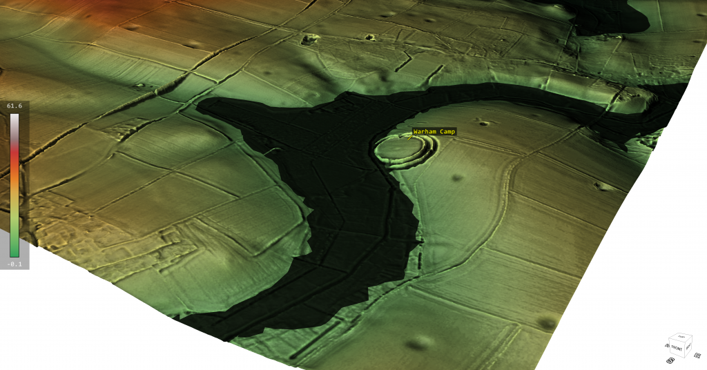
Recently I have been in conversation with FB members who have identified a little known henge (to me at least!) in Norfolk. The discussion was around if the locals had rerouted the local stream (River Stiffkey) towards the ancient henge (Warham Camp) and consequently , by design, removed the huge chalk banks to accommodate this redesign – this was a flood prevention scheme of the past according to local records. Moreover, there was a suggestion that the river had originally lay on the opposite side of the henge, on top of the hill? – (Henge and River Relationship)
When I looked at the site via Google Earth, there was a sudden realisation that most of this story was just misplaced and confused fantasy and nonsense. The site had been built at a direct angle on the edge of a hill (plenty of flat places to built the henge elsewhere) were this strange angle and dip into the local river would have not occured – so clearly it was purpose built.
The LiDAR maps show that this henge ‘dips’ into an ancient river channel of the past and as the animation shows when this river is replaced by the larger ancient water levels the design and location of the henge finally makes sense as it is a harbour to the river and the ditches would have been used for boats as a mooring canal. Furthermore, if we look at the road that goes over the hill on the opposite side River – it’s strangely ‘wibbly wobbly’ and not straight – this would suggest that it was once a manmade ‘Dyke’ a short-cut that went over the hill from river to river, which (like some dykes) the bank was used at a later date to build a road (and explain the local mythology?).
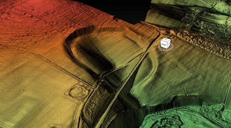
However, this is not the only Henge that is closely linked to Rivers and their use as trading posts with canal facilities for boats. The most famous recently found henge henge that also has half of the henge walls missing in relation to the local river is ‘Marden Henge’ near Stonehenge and down river from Avebury.

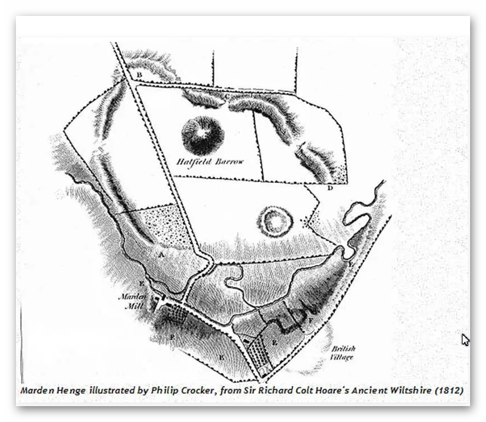
Interestingly the archaeologists of this site (you would imagine) would have analyses why this henge was placed so close to the River Avon – but as you see from the book extracts below…. it’s not even mentioned?
What was originally commented upon was In the 1810 publication Ancient Wiltshire, where Colt Hoare describes it as a ‘deep and wide ditch. . . which in winter is nearly full of water, although the soil consists of a greenish sand.’ Soil of a sandy composition should allow decent drainage – the fact that the ditch (though it’s tempting to use the word moat) remained full of water throughout the winter months is a probable indication of the water table being swollen by winter rain rather than being filled by it from above. The English Heritage geophysical survey shows the ditch in great clarity – their estimate of its size is 25 m across, and 105 m in diameter, with the remains of the barrow showing as a comparatively small island in the centre.
Henge with moated ditches…. my oh my…. are we seeing an archaeologist supporting my Post-Glacial Hypothesis..LOL!! – well I’m sure the academic world will attempt to qualify it as ‘the only one’…… but its not!!

You would expect modern archaeologist to have read up on Sir Richard Colt Hoare’s investigation and the obvious link to a river in their papers and books….. yet sadly they seem to ignore the obvious for the more obtrusive aspects of the site?
AUBREY BURL
“Earthworks like those at Waulud’s Bank, Durrington Walls, Marden, Mount Pleasant, all in southern England, seem to have been put up on the sites of earlier unenclosed settlements of the middle Neolithic once occupied by the users of Windmill Hill pottery. Forest clearance and crop growing had been followed by a long cessation of cultivation before the earthworks were thrown up as many as five centuries later. In every one of these enclosures Grooved Ware has been found.”
Burl, A (2002). Prehistoric Avebury. Yale. P125
“At the earthwork of Marden, the Grooved Ware settlement only a few miles south of Avebury in the marshy vale of Pewsey, the body of a young woman who seemed to have suffered from malnutrition in her childhood was put in the ditch alongside the north entrance. Again, this could have been an ordinary burial but, if so, it is remarkable that the body of yet another young woman should have been found at Avebury’s south entrance, buried there like the skeleton at Marden some time after the ditch was dug.”
Burl, A (2002). Prehistoric Avebury. Yale. P248
JAN HARDING
“Excavations at a number of the henge monuments located across the chalklands of Wiltshire and Dorset have produced large quantities of Grooved Ware pottery, and this has lead some to consider both monument and pottery as closely linked phenomena, even as components of a single socio-religious complex of artefacts, practices and beliefs.”
Harding, J (2003). Henge Monuments of the British Isles. Tempus. P12
“At a number of excavated sites, the ditch is certainly wider and deeper on either side of the causeway: at the ‘henge enclosure’ of Marden, in Wiltshire, it expanded to 59ft (18m) wide and about 10ft (3m) deep instead of the more normal 52.5 (16m) and 6.5 (2m) respectively (Wainright 1972, 185-7), whilst two of the three excavated terminals at the double entrance site of Arbor Low were deeper than elsewhere around its circuit (Gray 1903).”
Harding, J (2003). Henge Monuments of the British Isles. Tempus. P66
JOSH POLLARD
“Other large mounds of similar date are known closer to Avebury, including those at Marden in the Vale of Pewsey (Wainright 1971) and Mount Pleasant, Dorset (1979). Both are associated with henge enclosures. These are not on the same scale as the final phase of Silbury, though close in size to Silbury I and II (Thomas 1999, 216). The massive mound in the grounds of Marlborough College might be another, while the curiously large mound and wide ditches that form the Beckhampton long barrow (adjacent to the ditched enclosure) provide a tantalising possibility that this monument was enlarged and elaborated during the late Neolithic.”
Pollard J & Reynolds, A (2002). Avebury, The Biography of a Landscape. Tempus. P121
“The postholes of large timber circles, originally comprising multiple concentric rings of posts of telegraph-pole size, were discovered within the interiors of Durrington Walls and Mount Pleasant; another may exist within Avebury; and a smaller example was discovered just inside the northern entrance at Marden.”
Pollard, J (1997). Neolithic Britain. Shire. P43
MARTIN GREEN
“Due east of the centre circle, covered in trees, is the great mound still surviving to a height of 6.5m. Two concentric ditches surround it, one within 5m of the mound and the outer, segmented ditch, set some 30m distant from it. It is possible that this outer ditch, over 10m in diameter, is in fact a fifth henge which enclosed the likely earlier mound. Supporting this hypothesis are some aerial photographs that clearly reveal traces of an external bank. A rescue excavation in 1958 (Field 1962), following a pipe trench which cut the ditch, uncovered a profile apparently less than 2m deep which is admittedly rather un-henge like.
However, bearing in mind the causewayed nature of the ditch, the profile could vary significantly around its circuit. Nothing is known of this mound but similar combinations of henges and large mounds are known in other parts of the country — notably at Arbor Low in Derbyshire, Marden in Wiltshire and the most extreme example of all Silbury Hill and the Avebury complex. The large Neolithic round mound Duggleby Howe on the Yorkshire Wolds is now known to lie at the centre of a surrounding causewayed enclosure (Selkirk 1980). Silbury Hill is known to date from 3000 BC and it is likely that the other mounds are of broadly similar date.”
Green, M (2000). A Landscape Revealed – 10,000 years on a Chalkland Farm. Tempus. P90
ALEX GIBSON
“A more common ceramic association with timber circles is Grooved Ware. This sometimes plain but often highly decorated flat-based ceramic occurs at 16 (timber circle) sites and most notably at large, elaborate, complex circles. These are the large Wessex sites of Durrington Walls, Mount Pleasant, and Marden.”
Gibson, Alex (2005) Stonehenge and Timber Circles. Tempus. P66
“Beaker [pottery] was unusually found at Durrington Walls North Circle (Phase II) and South Circle (Phase II) and at the Sanctuary (though largely from the later stone holes). The Durrington contexts suggest that the Beaker represents a secondary activity at the site and that the sherds were recovered from the upper fills of pits or settling cones in the tops of the dismantled post rings. Like the other sites, therefore, the Beaker at Durrington represents a terminus ante quem for the circles. At Mount Pleasant and Marden the Beaker sherds were likewise not in primary contexts.”
Gibson, Alex (2005) Stonehenge and Timber Circles. Tempus. P68
“Most notably at the large Wessex henges, where chalky soil is conducive to the survival of faunal remains, there appears to be evidence for feasting. This would appear to have taken place at Durrington Walls, Mount Pleasant, Marden and Woodhenge, and is represented by the large quantities of bones of immature or young adult pig and other domesticated animals recovered from the excavations at these sites.”
Gibson, Alex (2005) Stonehenge and Timber Circles. Tempus. P105
MIKE PARKER PEARSON
“The huge grey sarsen uprights that can be seen today at Stonehenge were put up around 2400 BC (Phase 3ii). No one knows precisely where they came from but their most likely source is thought to be the Marlborough Downs about 20km (12 miles) to the north. However, reports of large buried sarsens near the henge enclosure at Marden, 15 km (9 miles) to the north, hint at a less distant origin.”
Parker Pearson, M (2005). Bronze Age Britain. Batsford. P65
JULIAN THOMAS
“When completed, Silbury would have had an imposing appearance, with stepped concentric revetment walls of chalk blocks, infilled with rubble (Whittle 1997a, 25). The connotations of this architecture are arguable. It may be that the various remodellings were attempts to draw upon quite different traditions derived from different places. In this way the earlier mounds find parallels in the Hatfield Barrow inside the Marden henge, the nearby Marlborough Mound (if indeed it is Neolithic in date: Whittle 1997a, 169–70), the Conquer Barrow in southern Dorset, and the large round mounds of Yorkshire. The final phase, by contrast, may be modelled on the passage tombs of the Boyne Valley and Brittany, traditions whose use had long lapsed by the time that Silbury was completed. Whittle (1997a, 147–9) suggests even more far-flung prototypes for the great mound.”
Thomas, J (2002). Understanding the Neolithic. Routledge. P217
TIMOTHY DARVILL
“Like causewayed camps before them, henges in southern England may have performed a variety of functions and most probably changed their role over the course of time. The majority were probably somehow utilized as ritual monuments, but three large sites in Wessex—Mount Pleasant, Dorset, Marden, Wiltshire and Durrington Walls, Wiltshire—stand apart from the others in having abundant evidence for occupation within them, including timber buildings, middens and large amounts of occupation debris. Indeed, Mount Pleasant contains within its bounds a conventional henge, and Durrington Walls has a similar structure just outside its perimeter at Woodhenge. The site at Waulud’s Bank, Luton, Bedfordshire, may also belong to this group of henge enclosures.”
Darvill, T (1987) Prehistoric Britain. Routledge. P82
BARBARA BENDER
“At Avebury there is also a dramatic link-up between the Avebury circle, the Avenue and Sanctuary, and the great stepped white mound of Silbury. From the Sanctuary the ‘hill’ takes up the low ground, and picks up the sky-line between two long hill ranges (Jarman, pers. comm.). Moving either down or up the Avenue the hill comes in and out of sight, and it can again be seen from the great encircling bank (perhaps a viewing platform) at Avebury. There are, or were, other artificial white hills, one to the east of Avebury in the grounds of what is now Marlborough College, another southward at Marden on the route between Avebury and Stonehenge, and perhaps yet another at Silk Hill, 5 km northeast of Stonehenge.”
Bender, B (1992). Theorising Landscapes, and the Prehistoric Landscapes of Stonehenge. Royal Anthropological Institute of Great Britain and Ireland. P 784.
JSTOR Stable URL – http://www.jstor.org/stable/2804172?origin=JSTOR-pdf
MIKE PITTS
“At Durrington Walls, the size and positioning of his trenches were determined by the roadworks. At Marden, Wainright could choose where he wanted to dig. Tony Clarke’s geophysical survey was no help, as the wet sandy subsoil yielded no clues, So Wainright decided to dig at the one entrance that was accessible, that to the north. At the Walls, the large southern circles were close to the southern entrance, and the end of the ditch there had been particularly rich in pottery and other finds. And, lo and behold, in their relatively small trench just inside the entrance they found the post holes of a simple, circular structure, and in the ditch a human skeleton, red deer antlers and quantities of Grooved Ware exactly like that found at Durrington Walls.”
Pitts, M (2000). Hengeworld. Arrow. P64
The latest of the investigations is been by Jim Leary, of Reading university – the conclusion of his work in 2010 – is best summed up in this video.
Typical modern archaeologists failing to understand the significance of the site and why they were created taking hundreds of working hours. This video sadly shows the state of current archaeology, with more questions than answers and the solutions they do suggest are based on very unscientific evidence as ‘ceremonial’ and ‘religious’ concepts which quite frankly is just ‘bad science’. But at least Jim actually mentioned the River Avon – even if he failed to understand the true relationship and why the gigantic moats were once full of water!!
Oh by the way…. the gigantic mount (like Silbury Hill) was empty of bodies (like Marlborough Mound) due to the fact these are fire beacons to attract ships and boats to the camp…. history can be painfully obvious..to some?
Let’s look at the LiDAR map video of Marden Henge that shows the size and function within in the landscape.
Finally, the most famous Henge that meet a major river is Durrington Walls – the LiDAR map clearly shows (like the previous examples) the site was built tilted to the enlarge river of the past and hence it does not have banks or ditches in this section. Durrington is slightly different as it looks like when the River retreated as the river levels shrank, the builders attempted to prolong the use of the site by adding ditches which were much smaller and shallower than the original sites feature showing it was adapted much later in history. This adaption included a ‘dyke’ cut from the lower river shoreline to the original banks in the west of the site.
Further Reading
For information about British Prehistory, visit www.prehistoric-britain.co.uk for the most extensive archaeology blogs and investigations collection, including modern LiDAR reports. This site also includes extracts and articles from the Robert John Langdon Trilogy about Britain in the Prehistoric period, including titles such as The Stonehenge Enigma, Dawn of the Lost Civilisation and the ultimate proof of Post Glacial Flooding and the landscape we see today.
Robert John Langdon has also created a YouTube web channel with over 100 investigations and video documentaries to support his classic trilogy (Prehistoric Britain). He has also released a collection of strange coincidences that he calls ‘13 Things that Don’t Make Sense in History’ and his recent discovery of a lost Stone Avenue at Avebury in Wiltshire called ‘Silbury Avenue – the Lost Stone Avenue’.
Langdon has also produced a series of ‘shorts’, which are extracts from his main body of books:
For active discussions on the findings of the TRILOGY and recent LiDAR investigations that are published on our WEBSITE, you can join our and leave a message or join the debate on our Facebook Group.
To understand why rivers were larger in the past we have video with all the relevant information.


