Historic River Avon
Contents
Case Study – Historic River Avon (from the book ‘Post-Glacial Flooding Hypothesis’)
The Quaternary deposits within the Avon Valley encompass a range of geological constituents, including clay-with-flints, head, gravelly head, river terrace deposits, brick earth, alluvium, and sporadic peat. Clay-with-flint deposits, being of residual nature, have resulted from the alteration of Palaeogene sediments and the dissolution of the underlying chalk, with their formation predating that of river terrace deposits. While the precise age remains uncertain, it is likely that clay-with-flint deposits in the southwest of England date back to the Pleistocene epoch (Gallois, 2009).
Head deposits, often found on the upper slopes of the valley, are closely associated with clay-with-flint sediments and are believed to have formed through processes such as solifluction and the dissolution of underlying bedrock. Moving downstream within the valley, deposits like ‘head gravel,’ ‘gravelly head,’ and ‘head’ are deposited through various mechanisms, including fluvial transport, hill wash, hill creep, and solifluction (Barton et al., 2003; Hopson et al., 2007).
Fluvial deposits in the region comprise a series of 14 river terraces, with the highest terraces situated approximately 100 meters above the Avon Valley floor, extending up to 12 kilometres in width from the present-day river axis. In contrast, the lower terraces within the Avon catchment have widths ranging from 3 to 6 kilometres and are located alongside and below the current river. The extensive coverage and limited altitudinal variation of the highest terraces suggest their deposition as draped layers over the landscape (Clarke and Green, 1987).
These terraces maintain relatively consistent thicknesses along the valley, a characteristic often observed in systems where sediment overloading from upstream and input from tributaries to the central valley play a role. Lateral erosion and the redeposition of fluvial sediments are likely contributing factors (Brown et al., 2009a, b). This mechanism could account for the progressive reduction in floodplain width observed between successive erosion-aggradation phases (Brown et al., 2010).
The presence of a substantial number of terraces in the Avon Valley raises questions regarding their direct linkage to Marine Isotope Stage (MIS) cycles, as suggested by some terrace formation models (Bridgland, 2000).
In discussing the Avon terraces and pre-Quaternary geology, a publication titled ‘Crustal uplift in Southern England: evidence from a river terrace records’ has highlighted several terraces from the River Avon still visible in the Hampshire basin, designated as T5 to T10.
‘Little has been done to determine the age of either the terrace sequence or the older River Gravels in the Avon Valley’
However, the age of these terrace sequences and the older River Gravels in the Avon Valley remains relatively understudied. There have been some indications of interglacial sediments within the two lowest terraces of the Solent, assigned to OIS 7 and OIS5e, with organic remains of probable Ipswichian (OIS 5e) and probable early Devensian age described from sediments beneath low-level terraces in the Avon Valley. However, no organic remains have been reported at higher elevations in the valleys of the Avon and its tributaries (Allen et al., 1996; Barber and Brown, 1987; Green et al., 1983).
Recent research, specifically ‘Pleistocene landscape evolution in the Avon Valley, southern Britain: Optical dating of terrace formation and Palaeolithic Archaeology’ by Egberts et al. (2019), has generated results challenging previous geological dating methodologies for river terraces. Optical Stimulated Luminescence (OSL) dating results for T10-7 suggest deposition during or prior to MIS10/9, which includes the Last Glacial Maximum (LGM). These findings, while broadly aligned with prior relative chronologies, potentially offer refinements for dating the archaeological record of T7 and for calculating regional uplift and incision rates (Egberts et al., 2019).
In summary, the Avon Valley’s geological formations, including river terraces, exhibit complexity and have been the subject of ongoing research, especially regarding their formation processes and chronological interpretation.The Quaternary deposits in the Avon Valley encompass a variety of geological formations, including clay-with-flints, head, gravelly head, river terrace deposits, brick earth, alluvium, and occasional peat (Gallego-Sala et al., 2016). Clay-with-flint deposits are residual and have formed through the alteration of Palaeogene sediments and the dissolution of the underlying chalk, with similar deposits in southwest England likely attributed to the Pleistocene epoch (Gallois, 2009).
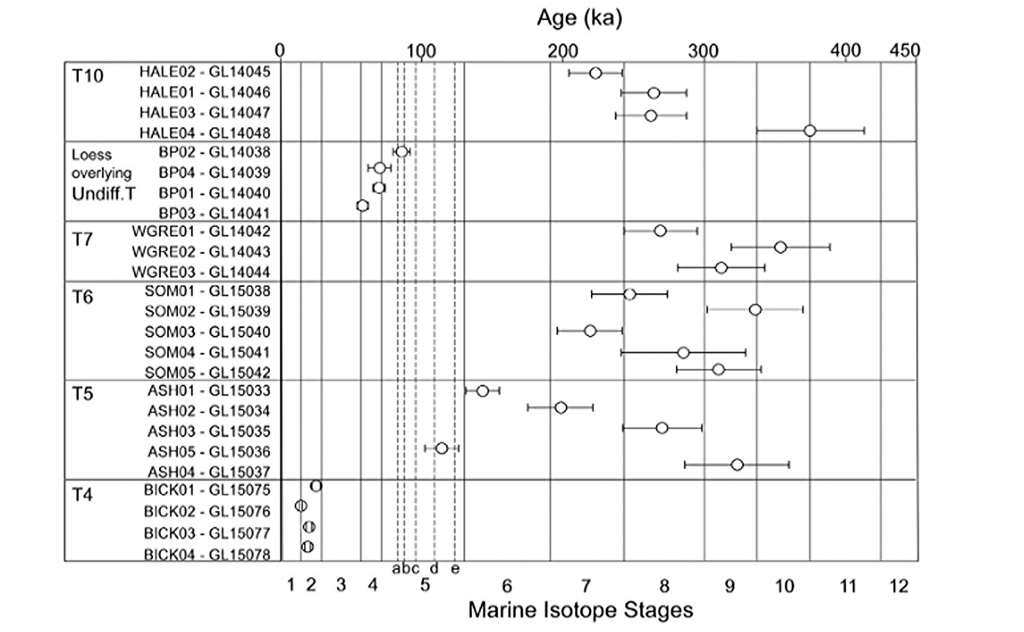
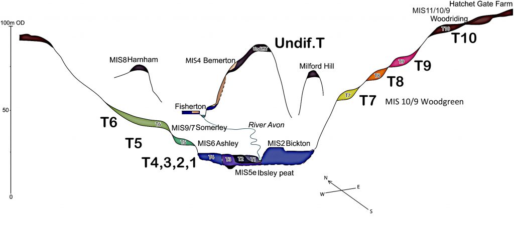
The diagram in Fig.62 presents the OSL results per terrace and in relationship to the MIS stages. The schematic valley cross-section shown in Fig. 63 is also based on the 3D model of the superficial geology of the Avon Valley, built-in Rock works based on BGS borehole data. The OSL ages for T10-7 suggest deposit during or before MIS10/9 (Fig. 5 – including the LGM). They broadly agree with, but potentially offer a refinement of, previously proposed relative chronologies used for dating the archaeological record of T7 and the calculation of regional uplift and incision rates.

| Figure 62 – OSL Results Avon River |
The initial analysis of these results reveals a somewhat perplexing pattern characterised by inconsistencies and, in some cases, what appears to be a near-random sequence. These findings have surprised our research team as they deviate from the expected chronological order. For instance, the terrace labelled T10, positioned at the highest elevation 102 meters above Ordnance Datum (OD), was determined through Optical Stimulated Luminescence (OSL) dating to have formed over more than 200,000 years. This is a significant departure from the anticipated sequence.
Further complicating is the revelation that T7, situated at a lower elevation of 58 meters OD, has been dated as older than T10. Such findings challenge the previously held hypothesis regarding the age sequence of these terraces. However, perhaps the most compelling evidence highlighting the inadequacies of the older dated terrace hypothesis is the Loess Terrace, positioned at an elevation of 77 meters OD and classified as ‘Undifferentiated T.’ According to OSL dating, this terrace was formed during the Last Glacial Maximum (LGM), a period associated with extreme cold conditions. In a similar vein, T4, another terrace, also yields the youngest dates among the samples.
These findings underscore the complexity and intricacies involved in deciphering the history of these terraces. The results defy conventional expectations and challenge assumptions about their formation and chronology.

| Figure 63- Avon River Terrace Levels |
The authors attempted to account for the intriguing results by proposing possible explanations. They suggested, “Therefore, more plausible explanations for this discrepancy between the age estimate of T4 at Fisherton and that at Bickton are either that T4 at Bickton includes sediments ‘reworked’ during more recent fluvial processes or that T4 is a ‘compound’ terrace exhibiting differing depositional behaviour in the upper and lower catchments.”
However, it’s important to note that the reliability of the Optical Stimulated Luminescence (OSL) dating method used in this study raises some questions. Notably, there are instances of questionable dates, particularly within the same soil level. For example, sediment sample GL 14039 was dated as 70ka +/- 8, while sediment sample GL14041 at the same level was dated 58ka +/- 4. Similarly, sample GL14038 was dated 86ka +/- 6, and sample GL14040 was dated 70ka +/- 4, both at the same soil level. Such inconsistencies raise doubts about the accuracy of OSL dating.
These uncertainties in dating are reminiscent of the historical challenges faced by radiocarbon dating, which has seen improvements over time. It is possible that, as with radiocarbon dating, OSL dating methods may become more precise and reliable over the next few decades.
Additionally, a 14C vs. OSL dating paper (Gaigalas, 2000) revealed discrepancies between OSL and carbon dating, with OSL dates being significantly older, suggesting that OSL may overestimate ages by 30% to 40%. This observation is consistent with the dating range presented in Fig.50, indicating potential inaccuracies in OSL dating.
Furthermore, it is essential to consider the impact of the Holocene river floods on the deposition of sediments and terraces. The study identified over one hundred such floods, some lasting hundreds of years, which would have contributed to the erosion and sedimentation dynamics in the region. These floods, driven by intense precipitation and the flow of rivers, played a significant role in reshaping the landscape.
This may explain the apparent absence of sufficient alluvium or colluvium at Stonehenge Bottom during the Mesolithic and Neolithic periods.
In conclusion, while the study’s findings present challenges and inconsistencies, they underscore the need for a more comprehensive approach that combines multiple dating methods, accurate modelling of deposit thickness, and a nuanced understanding of landscape evolution to unravel the system’s and diachronic evolution complexities.
UPDATE
More Empirical Evidence of Post-Glacial Flooding and a Flooded Stonehenge

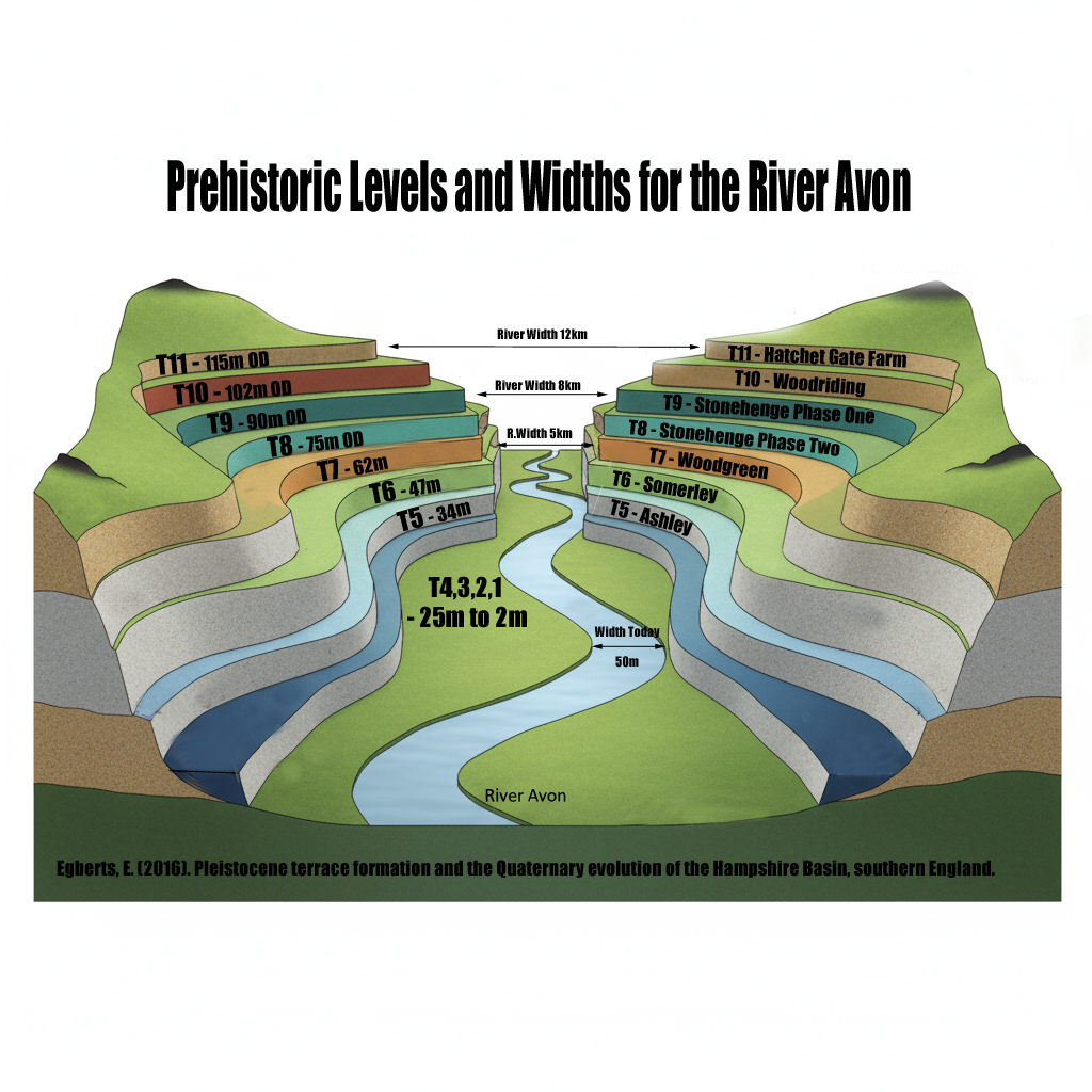
Prehistoric Levels and Widths for the River Avon
Take a close look at this illustration. It is not speculation, it is empirical science — mapped and measured river terraces from the Avon Valley, published in Egberts (2016), Pleistocene terrace formation and the Quaternary evolution of the Hampshire Basin, Bournemouth University.
What are we looking at?
- These are the terrace steps cut by the River Avon over multiple glacial–interglacial cycles.
- Each “T-level” marks a former stable floodplain where the river held its height for centuries, often millennia.
- The heights are measured in metres OD (Ordnance Datum) and tied to known quarry and pit sites (e.g. Hatchet Gate Farm, Woodgreen, Somerley, Ashley).
 How much bigger was the Avon?
- Today, the river meanders with a width of just ~50 m near Salisbury.
- At its maximum (T11), the Avon floodplain stretched ~12 km across.
- That is ~240 times wider than the river today.
 What does this mean for Stonehenge?
- Phase 1 of Stonehenge (Car Park Postholes) sits on T9 (~90 m OD).
- Phase 2 (ditch, Aubrey Holes, bluestones) cuts into T8 (~75 m OD).
- The terraces show that the palaeochannel not only flooded up to the old car park, but at times overtopped the entire Stonehenge site.
![]() Why this matters:
Why this matters:
- Terraces are not theory — they are empirical geomorphological evidence.
- They prove that the Avon has flooded to multiple levels, sometimes far higher than the monument itself.
- This is not about “if” water could reach those heights — the terraces prove it already has, repeatedly, over many Ice Age cycles.
So when critics dismiss the role of high water tables or argue “the site couldn’t have been wet,” they are ignoring the most basic geological record in front of us. The terraces are the diary of the river — written in gravel, chalk, and silt — showing that water rose and fell, over and over again.
![]() The real question is not if Stonehenge was surrounded by water. It is when, and how many times it happened during its long prehistory.
The real question is not if Stonehenge was surrounded by water. It is when, and how many times it happened during its long prehistory.
Further Reading
For more information about British Prehistory and other articles/books, go to our BLOG WEBSITE for daily updates or our VIDEO CHANNEL for interactive media and documentaries. The TRILOGY of books that ‘changed history’ can be found with chapter extracts at DAWN OF THE LOST CIVILISATION, THE STONEHENGE ENIGMA and THE POST-GLACIAL FLOODING HYPOTHESIS. Other associated books are also available such as 13 THINGS THAT DON’T MAKE SENSE IN HISTORY and other ‘short’ budget priced books can be found on our AUTHOR SITE. For active discussion on the findings of the TRILOGY and recent LiDAR investigations that is published on our WEBSITE you can join our FACEBOOK GROUP.
Other Blogs
1
a
- AI now Supports – Homo Superior
- AI now supports my Post-Glacial Flooding Hypothesis
- Alexander the Great sailed into India – where no rivers exist today
- Ancient Prehistoric Canals – The Vallum
- Ancient Secrets of Althorp – debunked
- Antler Picks built Ancient Monuments – yet there is no real evidence
- Antonine Wall – Prehistoric Canals (Dykes)
- Archaeological ‘pulp fiction’ – has archaeology turned from science?
- Archaeological Pseudoscience
- Archaeology in the Post-Truth Era
- Archaeology: A Bad Science?
- Archaeology: A Harbour for Fantasists?
- Archaeology: Fact or Fiction?
- Archaeology: The Flaws of Peer Review
- Archaeology’s Bayesian Mistake: Stop Averaging the Past
- Are Raised Beaches Archaeological Pseudoscience?
- Atlantis Found: The Mathematical Proof That Plato’s Lost City Was Doggerland
- ATLANTIS: Discovery with Dan Snow Debunked
- Avebury Ditch – Avebury Phase 2
- Avebury Post-Glacial Flooding
- Avebury through time
- Avebury’s great mystery revealed
- Avebury’s Lost Stone Avenue – Flipbook
b
- Battlesbury Hill – Wiltshire
- Beyond Stone and Bone: Rethinking the Megalithic Architects of Northern Europe
- BGS Prehistoric River Map
- Blackhenge: Debunking the Media misinterpretation of the Stonehenge Builders
- Brain capacity (Cro-Magnon Man)
- Brain capacity (Cro-Magnon Man)
- Britain’s First Road – Stonehenge Avenue
- Britain’s Giant Prehistoric Waterways
- British Roman Ports miles away from the coast
c
- Caerfai Promontory Fort – Archaeological Nonsense
- Car Dyke – ABC News PodCast
- Car Dyke – North Section
- CASE STUDY – An Inconvenient TRUTH (Craig Rhos Y Felin)
- Case Study – River Avon
- Case Study – Woodhenge Reconstruction
- Chapter 2 – Craig Rhos-Y-Felin Debunked
- Chapter 2 – Stonehenge Phase I
- Chapter 2 – Variation of the Species
- Chapter 3 – Post Glacial Sea Levels
- Chapter 3 – Stonehenge Phase II
- Chapter 7 – Britain’s Post-Glacial Flooding
- Cissbury Ring through time
- Cro-Magnon Megalithic Builders: Measurement, Biology, and the DNA
- Cro-Magnons – An Explainer
d
- Darwin’s Children – Flipbook
- Darwin’s Children – The Cro-Magnons
- Dawn of the Lost Civilisation – Flipbook
- Dawn of the Lost Civilisation – Introduction
- Digging for Britain – Cerne Abbas 1 of 2
- Digging for Britain Debunked – Cerne Abbas 2
- Digging Up Britain’s Past – Debunked
- DLC Chapter 1 – The Ascent of Man
- Durrington Walls – Woodhenge through time
- Durrington Walls Revisited: Platforms, Fish Traps, and a Managed Mesolithic Landscape
- Dyke Construction – Hydrology 101
- Dykes Ditches and Earthworks
- DYKES of Britain
e
f
g
h
- Hadrian’s Wall – Military Way Hoax
- Hadrian’s Wall – the Stanegate Hoax
- Hadrian’s Wall LiDAR investigation
- Hambledon Hill – NOT an ‘Iron Age Fort’
- Hayling Island Lidar Maps
- Hidden Sources of Ancient Dykes: Tracing Underground Groundwater Fractals
- Historic River Avon
- Hollingsbury Camp Brighton
- Hollows, Sunken Lanes and Palaeochannels
- Homo Superior – Flipbook
- Homo Superior – History’s Giants
- How Lidar will change Archaeology
i
l
m
- Maiden Castle through time
- Mathematics Meets Archaeology: Discovering the Mesolithic Origins of Car Dyke
- Mesolithic River Avon
- Mesolithic Stonehenge
- Minerals found in Prehistoric and Roman Quarries
- Mining in the Prehistoric to Roman Period
- Mount Caburn through time
- Mysteries of the Oldest Boatyard Uncovered
- Mythological Dragons – a non-existent animal that is shared by the World.
o
- Offa’s Dyke Flipbook
- Old Sarum Lidar Map
- Old Sarum Through Time…………….
- On Sunken Lands of the North Sea – Lived the World’s Greatest Civilisation.
- OSL Chronicles: Questioning Time in the Geological Tale of the Avon Valley
- Oswestry LiDAR Survey
- Oswestry through time
- Oysters in Archaeology: Nature’s Ancient Water Filters?
p
- Pillow Mounds: A Bronze Age Legacy of Cremation?
- Post Glacial Flooding – Flipbook
- Prehistoric Burial Practices of Britain
- Prehistoric Canals – Wansdyke
- Prehistoric Canals – Wansdyke
- Prehistoric Canals (Dykes) – Great Chesters Aqueduct (The Vallum Pt. 4)
- Prehistoric Canals (Dykes) – Hadrian’s Wall Vallum (pt 1)
- Prehistoric Canals (Dykes) – Offa’s Dyke (Chepstow)
- Prehistoric Canals (Dykes) – Offa’s Dyke (LiDAR Survey)
- Prehistoric Canals (Dykes) – Offa’s Dyke Survey (End of Section A)
- Prehistoric Canals (Dykes) – Wansdyke (4)
- Prehistoric Canals Wansdyke 2
- Professor Bonkers and the mad, mad World of Archaeology
r
- Rebirth in Stone: Decrypting the Winter Solstice Legacy of Stonehenge
- Rediscovering the Winter Solstice: The Original Winter Festival
- Rethinking Ancient Boundaries: The Vallum and Offa’s Dyke”
- Rethinking Ogham: Could Ireland’s Oldest Script Have Begun as a Tally System?
- Rethinking The Past: Mathematical Proof of Langdon’s Post-Glacial Flooding Hypothesis
- Revolutionising History: Car Dyke Unveiled as Prehistoric & the Launch of FusionBook 360
- Rising Evidence, Falling Rivers: The Real Story of Europe’s First Farmers
- Rivers of the Past Were Higher: A Fresh Perspective on Prehistoric Hydrology
s
- Sea Level Changes
- Section A – NY26SW
- Section B – NY25NE & NY26SE
- Section C – NY35NW
- Section D – NY35NE
- Section E – NY46SW & NY45NW
- Section F – NY46SE & NY45NE
- Section G – NY56SW
- Section H – NY56NE & NY56SE
- Section I – NY66NW
- Section J – NY66NE
- Section K – NY76NW
- Section L – NY76NE
- Section M – NY87SW & NY86NW
- Section N – NY87SE
- Section O – NY97SW & NY96NW
- Section P – NY96NE
- Section Q – NZ06NW
- Section R – NZ06NE
- Section S – NZ16NW
- Section T – NZ16NE
- Section U – NZ26NW & NZ26SW
- Section V – NZ26NE & NZ26SE
- Silbury Avenue – Avebury’s First Stone Avenue
- Silbury Hill
- Silbury Hill / Sanctuary – Avebury Phase 3
- Somerset Plain – Signs of Post-Glacial Flooding
- South Cadbury Castle – Camelot
- Statonbury Camp near Bath – an example of West Wansdyke
- Stone me – the druids are looking the wrong way on Solstice day
- Stone Money – Credit System
- Stone Transportation and Dumb Censorship
- Stonehenge – Monument to the Dead
- Stonehenge Hoax – Dating the Monument
- Stonehenge Hoax – Round Monument?
- Stonehenge Hoax – Summer Solstice
- Stonehenge LiDAR tour
- Stonehenge Phase 1 — Britain’s First Monument
- Stonehenge Phase I (The Stonehenge Landscape)
- Stonehenge Solved – Pythagorean maths put to use 4,000 years before he was born
- Stonehenge Stone Transportation
- Stonehenge Through Time
- Stonehenge, Doggerland and Atlantis connection
- Stonehenge: Discovery with Dan Snow Debunked
- Stonehenge: The Worlds First Computer
- Stonehenge’s The Lost Circle Revealed – DEBUNKED
t
- Ten Reasons Why Car Dyke Blows Britain’s Earthwork Myths Out of the Water
- Ten Things You Didn’t Know About Britain’s Prehistoric Flooded Past
- Ten thousand year old boats found on Northern Europe’s Hillsides
- Ten thousand-year-old boats found on Northern Europe’s Hillsides
- The “Hunter-Gatherer” Myth: Why It’s Time to Bury This Outdated Term
- The Ancient Mariners – Flipbook
- The Ancient Mariners – Prehistoric seafarers of the Mesolithic
- The Beringian Migration Myth: Why the Peopling of the Americas by Foot is Mathematically and Logistically Impossible
- The Bluestone Enigma
- The Cro-Magnon Cover-Up: How DNA and PR Labels Erased Our Real Ancestry
- The Dolmen and Long Barrow Connection
- The Durrington Walls Hoax – it’s not a henge?
- The Dyke Myth Collapses: Excavation and Dating Prove Britain’s Great Dykes Are Prehistoric Canals
- The First European Smelted Bronzes
- The Fury of the Past: Natural Disasters in Historical and Prehistoric Britain
- The Giant’s Graves of Cumbria
- The Giants of Prehistory: Cro-Magnon and the Ancient Monuments
- The Great Antler Pick Hoax
- The Great Chichester Hoax – A Bridge too far?
- The Great Dorchester Aqueduct Hoax
- The Great Farming Hoax – (Einkorn Wheat)
- The Great Farming Migration Hoax
- The Great Hadrian’s Wall Hoax
- The Great Iron Age Hill Fort Hoax
- The Great Offa’s Dyke Hoax
- The Great Prehistoric Migration Hoax
- The Great Stone Transportation Hoax
- The Great Stonehenge Hoax
- The Great Wansdyke Hoax
- The Henge and River Relationship
- The Logistical Impossibility of Defending Maiden Castle
- The Long Barrow and Dolman Enigma
- The Long Barrow Mystery
- The Long Barrow Mystery: Unravelling Ancient Connections
- The Lost Island of Avalon – revealed
- The Maiden Way Hoax – A Closer Look at an Ancient Road’s Hidden History
- The Maths – LGM total ice volume
- The Mystery of Pillow Mounds: Are They Really Medieval Rabbit Warrens?
- The Old Sarum Hoax
- The Oldest Boat Yard in the World found in Wales
- The Perils of Paradigm Shifts: Why Unconventional Hypotheses Get Branded as Pseudoscience
- The Post-Glacial Flooding Hypothesis – Flipbook
- The Post-Glacial Flooding Theory
- The Problem with Hadrian’s Vallum
- The Rise of the Cro-Magnon (Homo Superior)
- The Roman Military Way Hoax
- The Silbury Hill Lighthouse?
- The Stonehenge Avenue
- The Stonehenge Avenue
- The Stonehenge Code: Unveiling its 10,000-Year-Old Secret
- The Stonehenge Enigma – Flipbook
- The Stonehenge Enigma: What Lies Beneath? – Debunked
- The Stonehenge Hoax – Bluestone Quarry Site
- The Stonehenge Hoax – Flipbook
- The Stonehenge Hoax – Moving the Bluestones
- The Stonehenge Hoax – Periglacial Stripes
- The Stonehenge Hoax – Station Stones
- The Stonehenge Hoax – Stonehenge’s Location
- The Stonehenge Hoax – The Ditch
- The Stonehenge Hoax – The Slaughter Stone
- The Stonehenge Hoax – The Stonehenge Layer
- The Stonehenge Hoax – Totem Poles
- The Stonehenge Hoax – Woodhenge
- The Stonehenge Hospital
- The Subtropical Britain Hoax
- The Troy, Hyperborea and Atlantis Connection
- The Vallum @ Hadrian’s Wall – it’s Prehistoric!
- The Vallum at Hadrian’s Wall (Summary)
- The Woodhenge Hoax
- Three Dykes – Kidland Forest
- Top Ten misidentified Fire Beacons in British History
- Troy Debunked
- TSE – DVD Barrows
- TSE DVD – An Inconvenient Truth
- TSE DVD – Antler Picks
- TSE DVD – Avebury
- TSE DVD – Durrington Walls & Woodhenge
- TSE DVD – Dykes
- TSE DVD – Epilogue
- TSE DVD – Stonehenge Phase I
- TSE DVD – Stonehenge Phase II
- TSE DVD – The Post-Glacial Hypothesis
- TSE DVD Introduction
- TSE DVD Old Sarum
- Twigs, Charcoal, and the Death of the Saxon Dyke Myth
w
- Wansdyke – Short Film
- Wansdyke East – Prehistoric Canals
- Wansdyke Flipbook
- Wansdyke LiDAR Flyover
- Wansdyke: A British Frontier Wall – ‘Debunked’
- Was Columbus the first European to reach America?
- What Archaeology Missed Beneath Stonehenge
- White Sheet Camp
- Why a Simple Fence Beats a Massive Dyke (and What That Means for History)
- Windmill Hill – Avebury Phase 1
- Winter Solstice – Science, Propaganda and Indoctrination
- Woodhenge – the World’s First Lighthouse?


Pingback: AI now supports my Post-Glacial Flooding Hypothesis - Prehistoric Britain