Hadrian’s Wall Vallum – Prehistoric Canals – FREE Online Book
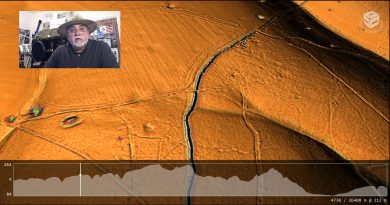
Promotional Video – Ancient Prehistoric Canals (Dykes) – The Vallum ( Hadrian’s Wall Vallum)
Introduction
Extract From Book……………………… Ancient Prehistoric Canals (Dykes) – The Vallum
Traditional archaeologists and archaeological establishments like English Heritage suggest that:
The Vallum is a massive earthwork constructed shortly after Hadrian’s Wall itself and lying just south of it. Many visitors confuse the Vallum with Hadrian’s Wall itself because it’s such an obvious and impressive feature in the landscape.
In fact, the Vallum is made up of several different elements – a ditch around 6 metres wide and 3 metres deep; two mounds either side of the ditch about 6 metres wide and 2 metres high and set back from the ditch by around 9 metres; and often a third mound on the southern edge of the ditch. The whole complex is around 36 metres across. Usually, the Vallum runs close behind the Wall, but in the rocky, hilly central section it lies up to 700 metres from the Wall.
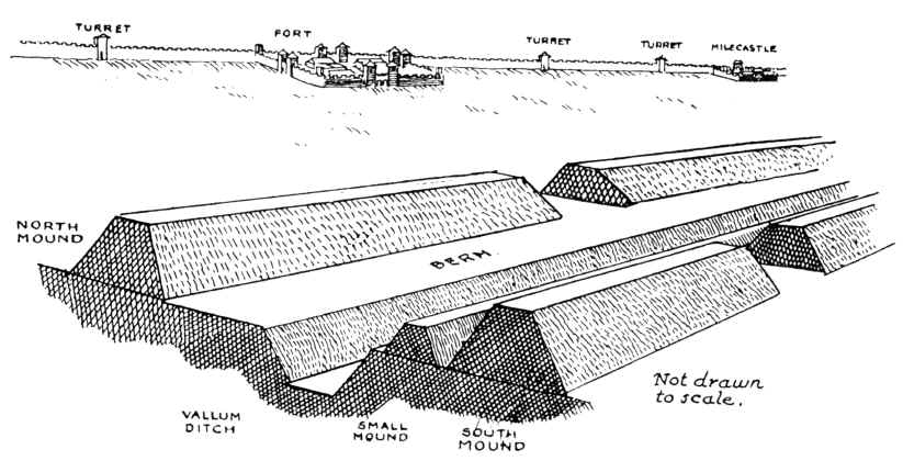
Crossing points seem to have been located south of each fort along Hadrian’s Wall and near several milecastles. Evidence from the excavated Vallum crossing at Benwell in Newcastle shows these crossing points had impressive monumental gateways.
The Vallum’s purpose is unclear. Many archaeologists think it marks the southern boundary of a military zone, with the Wall itself forming the northern boundary. This would have helped protect the rear of the Wall and its associated military installations, with civilian access being closely controlled. The gateway at Benwell supports this idea. The numerous gateways along the Wall at forts and milecastles suggest that the frontier was intended as much to control movement as to provide a defensive line. Traders would have moved goods across the frontier, but their movements would have been controlled and their goods taxed.
Relatively soon after it was constructed, some 20 to 30 years perhaps, the Vallum seems to have lost its function – the mounds were cut through and the ditch filled in at fairly regular intervals. It was out of use by the time the forts along the Wall were re-commissioned in the late second century AD following the return of the garrison from the Antonine Wall.
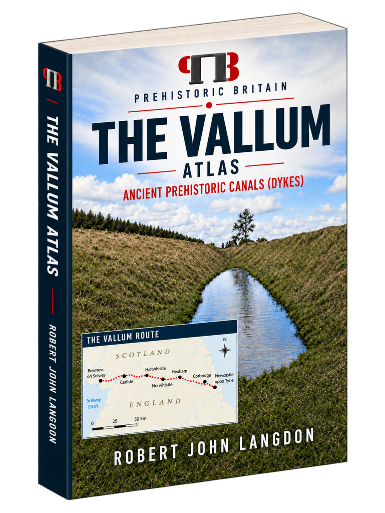
Sadly, these ideas, constructed over the last 200 years, are somewhat questionable. Within the book, we look at associated aspects of this area, like Military Way, which was supposed to be constructed to patrol the so-called ‘Military Zone’ – to find that:
Archaeologists describe over 50% of Military Way as not existing as a separate road. Instead, the perceived road is fragmented and only becomes ‘alive’ as an independent road when the Vallum separates from the wall at any distance.
This might give us a clue to the function of this rough and wonky road, as the stone for the wall would have needed to be delivered by cart if the Vallum canal was not available.
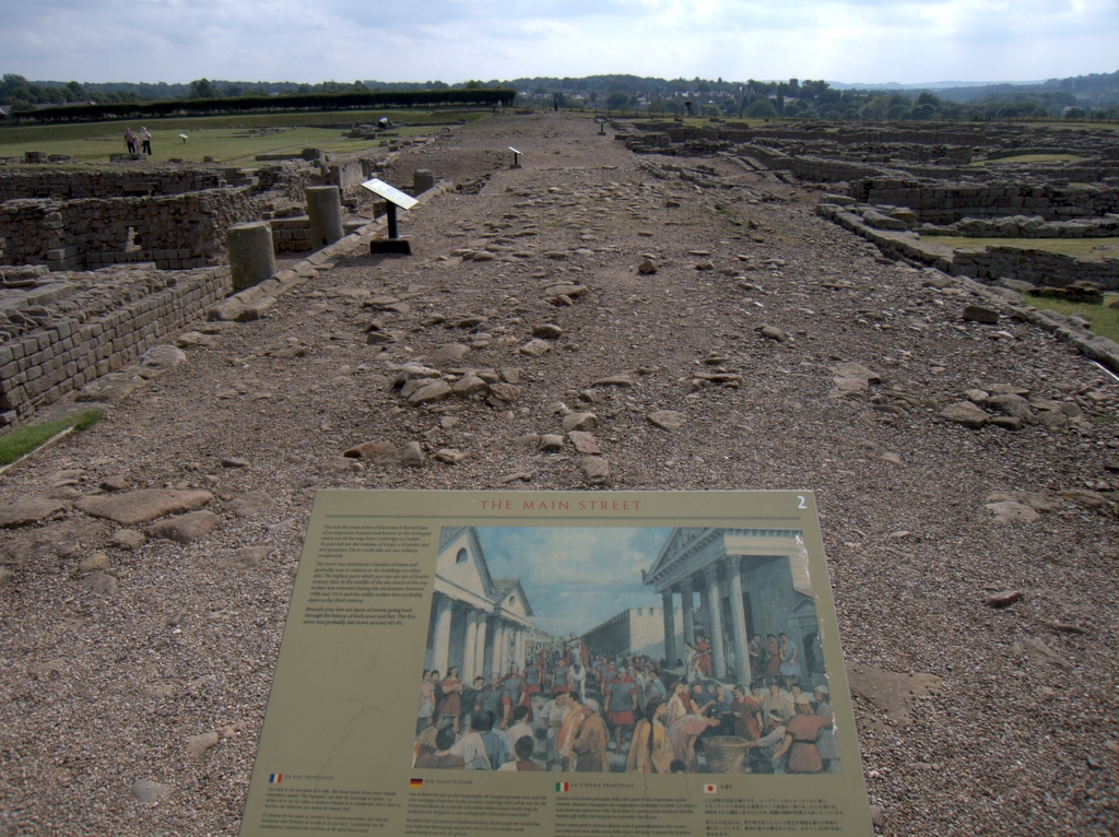
As for the Stanegate that was supposed to connect to the main forts in the area as a ‘defensive shield ‘, we actually found that it is very little to no evidence of the ‘Stanegate Roman Road’, which (according to the current theory proposed by English Heritage) ‘consolidated as a frontier’ during the late first and early second century AD and helped crystallise Roman tactics and military expectations in the area.
This evidence is compounded when you realise that, of the 80-mile border from coast to coast, Stonegate, at best, covers just 38.1 miles (47%) of the ‘defensive gap’, and hence suggestions of extension beyond the existing line existed (even without support from OS maps). Moreover, the research has shown the ‘raw’ Stanegate road without the ‘hidden’ parts below the B-roads – we are only looking at 20% of the declared road being visible on LiDAR maps.
Stanegate Road (when not part of an existing B-road system) is inconsistent in width and structure -moving from a bank track to a road with two ditches on each side to a ditch with two banks, far from straight, and usually starts and ends in ravines.
Most Forts and the Stanegate do not connect (with intersecting sub-roads) on only two occasions, and the rest show no connection. Moreover, later ‘temporary’ camps also did not connect to the road, which questions whether (a defence line) was its purpose.
Moreover, this would then question whether the ‘myth’ of using the Stanegate as a ‘boundary’ for withdrawing troops from Scotland in the first century AD is correct. It also raises whether the River Tyne (on which most of these Forts sit) served as a more practical and effective boundary/defence.
This ‘myth buster’ will not surprise many in academia, as it has been ‘hinted’ at for some time (but not acted upon by updating the literature), as Symonds et al. note.
“The question of whether a road even existed when the fortlets were founded is by default an existential one for the notion that they provided highway protection. But even if the metalled road does post-date the fortlets, a reasonably robust thoroughfare of some form must have existed from at least the mid AD 80s to service Vindolanda. The question is not whether there was a road, but whether it was metalled when the fortlets were founded.” Symonds, M. (2017). Hadrian’s Wall. In Protecting the Roman Empire: Fortlets, Frontiers, and the Quest for Post-Conquest Security (pp. 95-132)
Moreover, even if Stanegate was not built as suggested, it exists in parts and looks prehistoric (by design), as it relies heavily on ravens that start and end sections of the Stanegate; its sunken structure in parts is unfamiliar in traditional Roman Road design.
As for other famous ‘Roman Features ‘ such as the Great Chesters Aqueduct, again we find that not only is the origin questionable, but as it is located supposedly fully in ‘hostile territory ‘, its usefulness in conflict would be limited.
LiDAR research makes it clear that the suspected Roman Aqueduct is not what it seems. This is not the first examination to spread doubt about the scale and origin of this feature in the landscape – MacKay, D. A. (1990). The Great Chesters Aqueduct: A New Survey. Britannia, 21, 285–289. Also shows an incomplete map of this aqueduct.
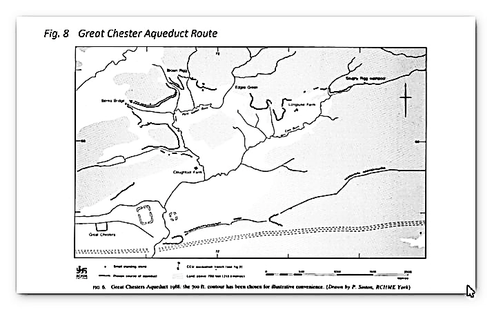
Mackey failed to find in their survey that the Aqueduct changed size, and the path suggested had no identifiable remains of the bridges required to make this Aqueduct work.
Our more detailed findings indicate that the aqueduct’s topology suggests it would need to go uphill at several points without any powered assistance (like a siphon), making it mechanically unsound. Our findings show that the use of ‘Dykes’ in this area, and some connections to this Aqueduct feature, is new. We have also shown that, closer to the Fort it was supposed to supply, there were closed water sources that could be used, and that the Fosse by the Wall was also a water supply.
We conclude that we found a prehistoric watercourse linked to their sophisticated ‘Dyke’ system. I would be bold to suggest this was used for either agricultural or industrial purposes, given the multiple quarry sites associated with this feature and the region.
Case Study – Stanegate Roman Road
Stanegate
According to Wikipedia:
The Stanegate (meaning “stone road”) was an important Roman road built in what is now northern England. It linked many forts, including two that guarded important river crossings: Corstopitum (Corbridge) on the Tyne in the east and Luguvalium (Carlisle) on the River Eden in the west. The Stanegate ran through the natural gap formed by the valleys of the River Tyne in Northumberland and the River Irthing in Cumbria. It predated Hadrian’s Wall by several decades; the Wall would later follow a similar route, slightly to the north.
The Stanegate differed from most other Roman roads in that it often followed the most accessible gradients and tended to weave around, whereas typical Roman roads followed a straight path, even if this sometimes meant punishing slopes to climb.
A large section of the Stanegate is still used today as a modern minor road between Fourstones and Vindolanda in Northumberland.
It is believed that the Stanegate was probably built under the governorship of Agricola, from 77 to 85 AD, during the reigns of the emperors Vespasian, Titus and Domitian. It is also thought to have been built as a strategic road when the northern frontier ran along the Forth and Clyde.
One indication is that it had forts at one-day marching intervals (14 Roman miles, or modern 13 miles (21 km)), sufficient for a strategic non-frontier road. The forts at Vindolanda (Chesterholm) and Nether Denton have been shown to date from about the same time as Corstopitum and Luguvalium, in the 70s AD and 80s AD.
When the Romans withdrew from Scotland around 105 AD, the line of the Stanegate became the new frontier, and they needed to provide forts at half-day-march intervals. Newbrough, Magnis (Carvoran), and Brampton Old Church were additional forts. It has been suggested that a series of smaller forts were built in between the ‘half-day-march’ forts (6.5m/10km). Haltwhistle Burn and Throp might be such forts, but insufficient evidence confirms a series of such fortlets.
Pretty straightforward, you would imagine – so where is the problem, you might ask?
According to English Heritage
The Stanegate Military Roman Road linked Corbridge and Carlisle, which were also situated on important north-south routeways. It also extended west of Carlisle towards the Cumbrian coast.
Building a series of forts along the road line allowed many troops to be stationed in this crucial frontier area and ensured the site could be extensively patrolled. A series of smaller watchtowers were also built to help frontier control. The Stanegate frontier thus developed and consolidated during the late first and early second century AD, helping crystallise Roman tactics and military expectations in the area.
The function of the road and its forts changed when Hadrian’s Wall was constructed to the north, and their support roles were, at least initially, enhanced. The later history of the road and its forts and their relationship with the Wall is less well understood, although, overall, their strategic functions declined as the new frontier line was confirmed.
Therefore!
Stanegate runs from Corstopitum (Corbridge) to Luguvalium (Carlisle), a distance of 13 miles, and was built between 77 and 85 AD, so it predates Hadrian’s Wall, but it’s unlike most Roman roads: it’s not straight and follows the contours of the landscape. Moreover, when the Romans withdrew from Scotland in 105 AD (Hadrian’s Wall was built in 122 AD), they used it as a frontier line.
But is it true?
Let’s look at the suggested route and use LiDAR to see if it is remotely true.
For Ease’s purpose, we will go from West to East for reasons that will become obvious at the end of the case study.
Route (according to English Heritage)
The Stanegate began in the east at Corstopitum, where the critical road, Dere Street, headed towards Scotland. West of Corstopitum, the Stanegate crossed the Cor Burn and followed the north bank of the Tyne until it reached the North Tyne near the village of Wall. A Roman bridge must have taken the road across the North Tyne, from where it headed west past the present village of Fourstones to Newbrough, where the first fort is situated, 7 miles (12.1 km) from Corbridge and 6 miles (9.7 km) from Vindolanda. It is a small fort occupying less than an acre, in the graveyard of Newbrough church, which stands alone to the west of the village.
From Newbrough, the Stanegate proceeds west, parallel to the South Tyne, until it meets the next major fort, at Vindolanda (Chesterholm). From Vindolanda, the Stanegate crosses the route of the present-day Military Road and passes just south of the minor fort of Haltwhistle Burn. From Haltwhistle Burn, the Stanegate continues west away from the course of the South Tyne and passes the major fort of Magnis (Carvoran), 6 miles (10.5 km) from Vindolanda and 20 miles (32 km) from Corstopitum. The Maiden Way joins the road from Epiacum (Whitley Castle) to the south.
From Magnis, the road turns southwest to follow the River Irthing, passing the minor fort of Throp and arriving at the major fort of Nether Denton, 4 miles (7.2 km) from Magnis and 24 miles (39.4 km) from Corstopitum. The fort covers about 3 acres (12,000 m2).
From Nether Denton, the road continues along the River Irthing and heads toward present-day Brampton. It passes the minor fort of Castle Hill Boothby and then, 1 mile (1.6 km) west of Brampton, reaches the next major fort, that of Brampton Old Church, 6 miles (9.7 km) from Nether Denton and 30miles (49.1 km) from Corstopitum. The fort is so-called because half of it is buried under Old St Martin’s church and its graveyard.
From Brampton Old Church, the road crosses the River Irthing, continues southwest through Irthington, and passes through what is now the site of Carlisle Airport, just north of the main runway. The curving corner of an associated marching camp can be seen from the air on the south edge of the runway near its western end and on Google Earth. The Stanegate then continued through an extensive cutting in High Crosby, where a small fort was postulated based on marching distances but was not yet found.
The Stanegate then crossed the River Eden near the cricket ground in modern Carlisle and eventually reached the fort of Luguvalium (Carlisle) on the site of Carlisle Castle, 7 miles (12.1 km) from Brampton Old Church and 38 miles (61 km) from Corstopitum. It has been suggested that the road may have carried west for a further 4 miles (7.2 km) to the Roman fort at Kirkbride overlooking Moricambe Bay, an inlet of the Solway Firth. A large camp of 5 acres (20,000 m2) was found there, but the evidence for a road is insufficient.
It has also been suggested that the Stanegate may have run eastwards from Corstopitum towards Pons Aelius, present-day Newcastle upon Tyne, possibly linking to Washing Wells Roman Fort in Whickham, but no evidence has yet been found to support this.
Notice that they are not in a straight line, and there are gaps in the forts, as this so-called 6.5-mile marching-gap rule is inconsistent or, in some cases, non-existent, as no archaeological evidence has yet been found.
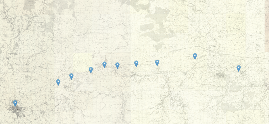
Here is what LiDAR makes of this road:
Carlisle to Brompton Section (7.8 miles/12.5 km – Direct)
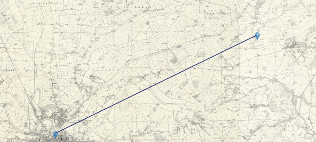
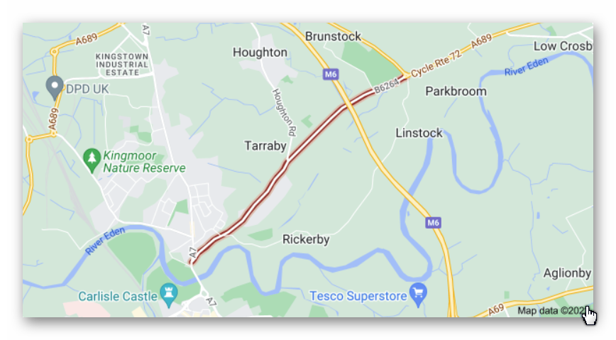
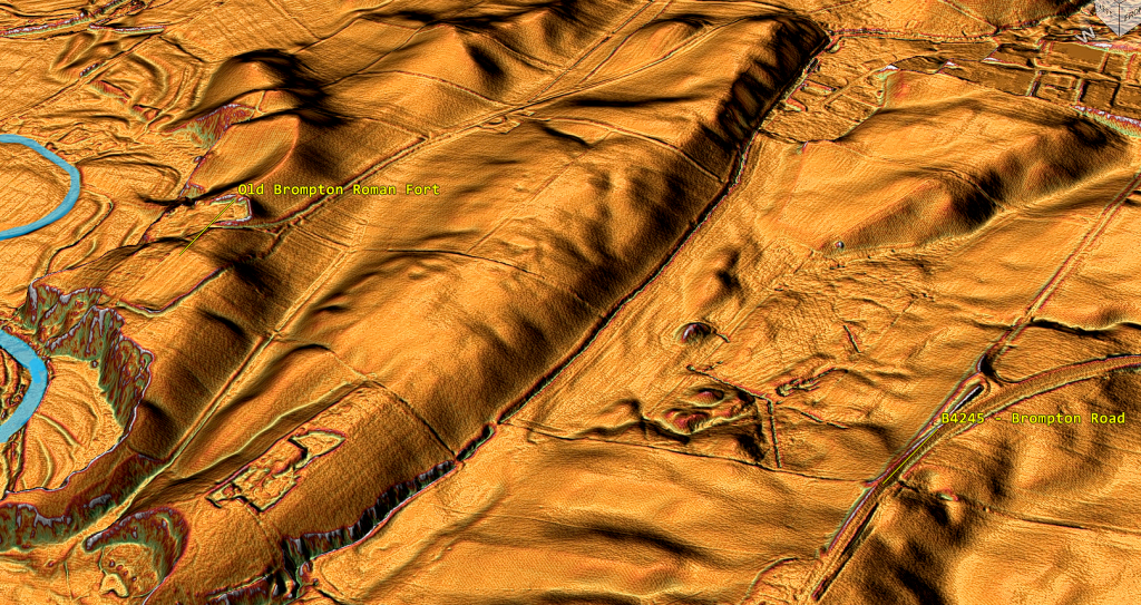
The most obvious route from Carlisle Castle (Luguvalium Roman Fort) to Brompton Fort is the B4245, which may have originally been the old ‘Stanegate road’, heading for Brampton Old Church via Irthington.
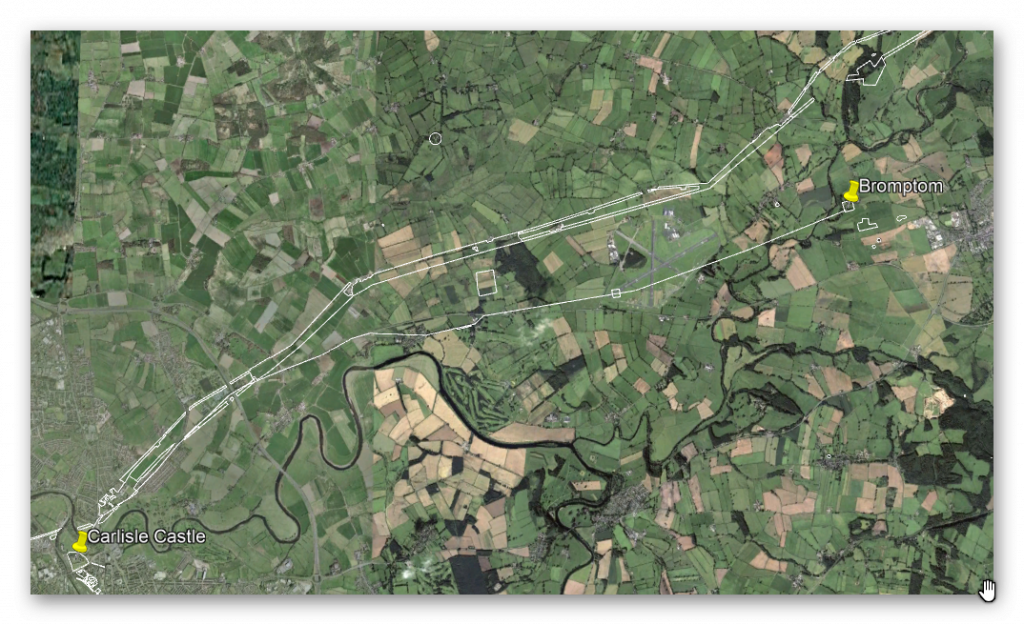
One would imagine you would stay on this bendy road until you get to Brompton, but the OS maps show that Stanegate veers off it at High Crosby?
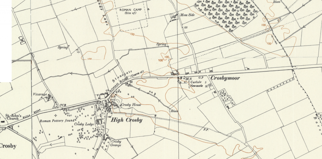
The problem is that (although the road has supposedly been spotted on Google Earth), LiDAR shows absolutely nothing.
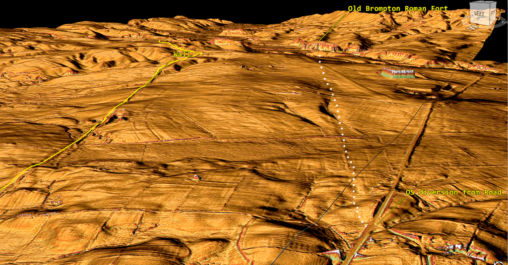
The road (which goes through Carlisle airport) abruptly ends at a massive ravine by the River Irthing. The fort has no direct road access (even if you continued on the B4245, there is no turn-off) until you reach Brompton, and then it’s a winding 1.5 miles / 2.4 km road (old church road). So, to supply this station, you will need a boat and its position on the river.
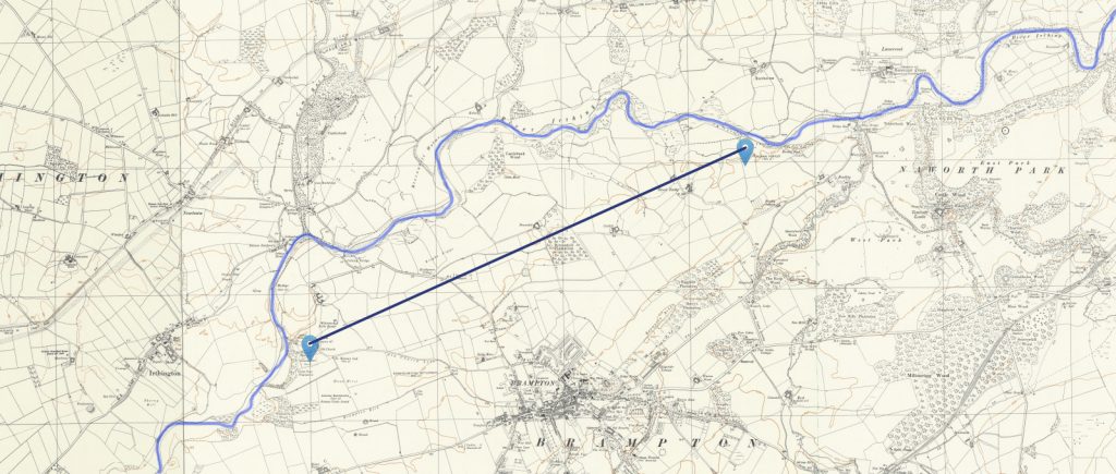
Brompton To Boothby Fortlet (2.4 miles / 3.8 km)
We can find no road on the OS maps that connects the two forts or any other scheduled monument. Likewise, there is nothing on the LiDAR map, and although Boothby Fort appears on Historic England’s listing as a scheduled monument on LiDAR, there is absolutely nothing or any road connection.
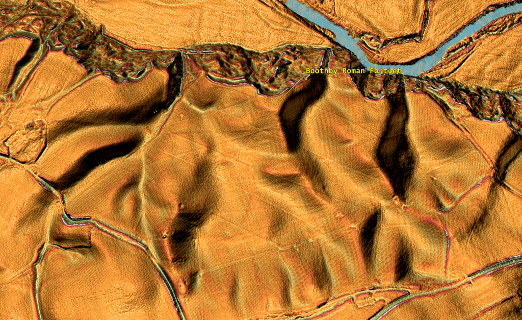
The only possibility is that the Roman Fortlet slipped into the old riverbed – this would suggest that the river must have been much more prominent and higher in the past.
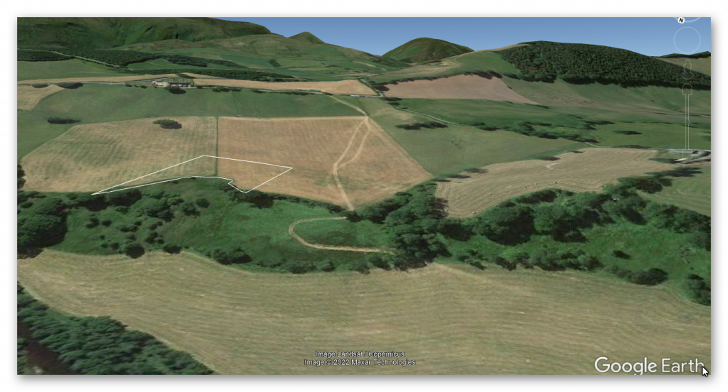
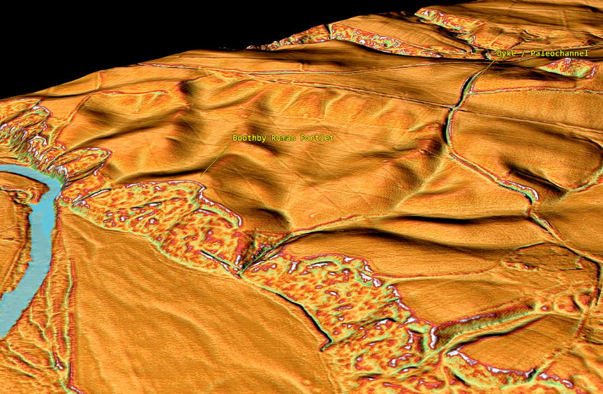
This raises the question of whether the site was Roman or prehistoric, as it has been identified only by air photos and a single excavation of a ditch. However, we have identified possible Dyke/paleo channels in this area, so it is possible that one of these Dyke/paleo channels was recognised in the 1947 air photographs as the side of the Roman Fort, and that the Dyke was partially excavated.
If we return to our LiDAR map of the area and flood it with a higher water table (10m over the current river level), we not only see why Boothby slid into the water (if it was a Roman Fort) but also see why Old Brompton Roman Fort was so isolated with no adjoining roads.
So what’s going on here?
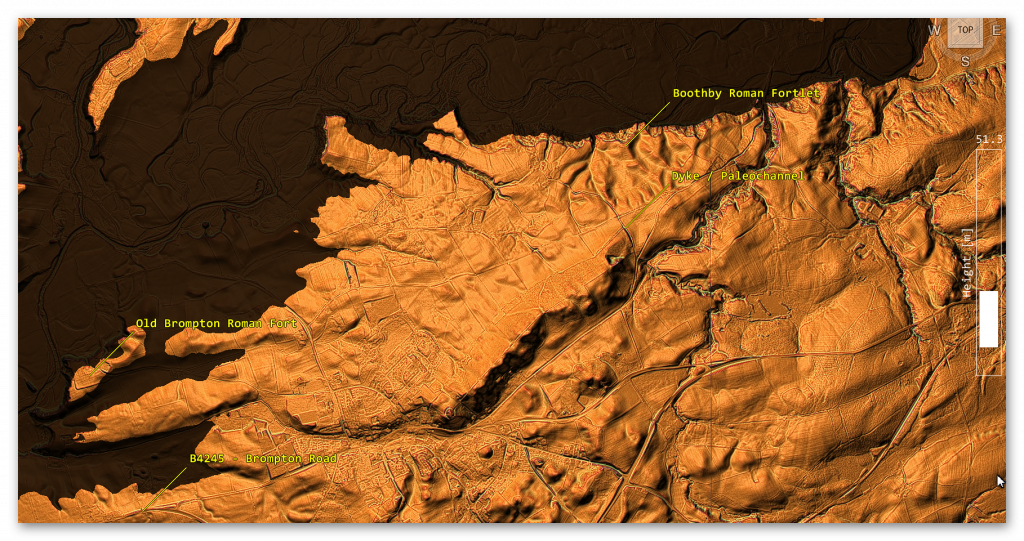
We have failed to find Stanegate Road (if the OS map is correct), and neither of the Roman Forts has any road connection to the Stanegate – even if the current Old Brompton Road is the real Stanegate.
Boothby to Nether Denton Roman Fort (3.4 miles / 5.4 km)
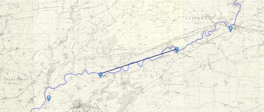
Again, no road (modern or old) connects Nether Denton Fort to Boothby; the only connection is the river, which archaeologists now suggest was the ‘natural’ boundary when the Romans retreated from Scotland in 105AD, before Hadrian’s Wall was constructed. (Symonds, 2017). The pathway to the south of the Fort stops at the river.
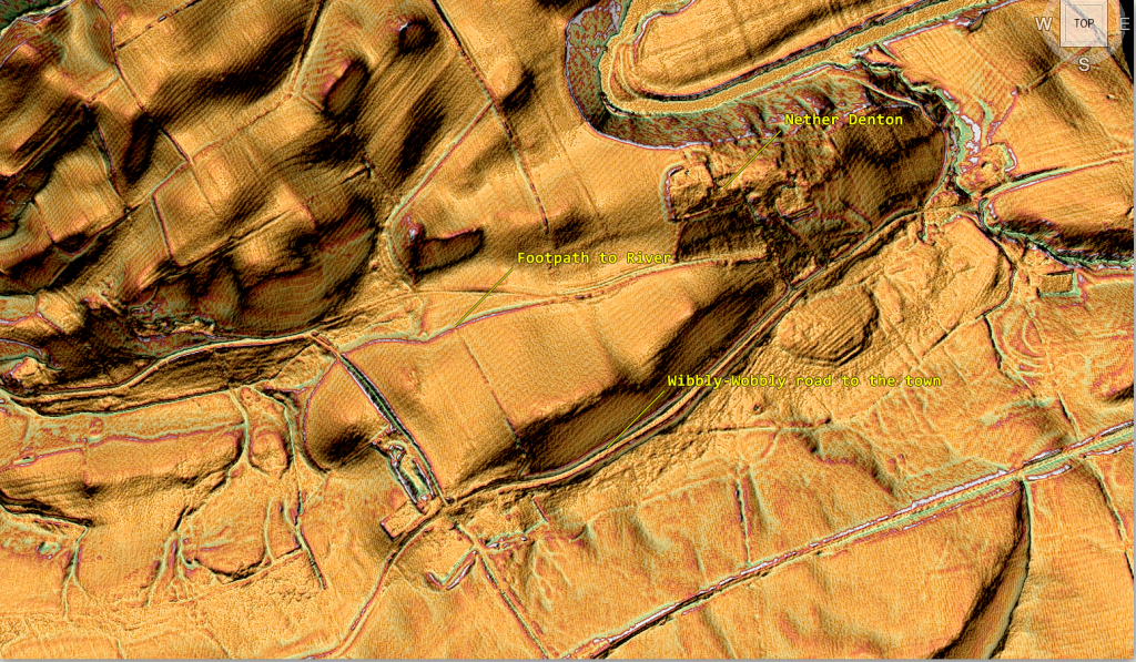
The first 5 Roman forts on the ‘Stanegate road’ are on the River Irthing and not connected by a single road!!
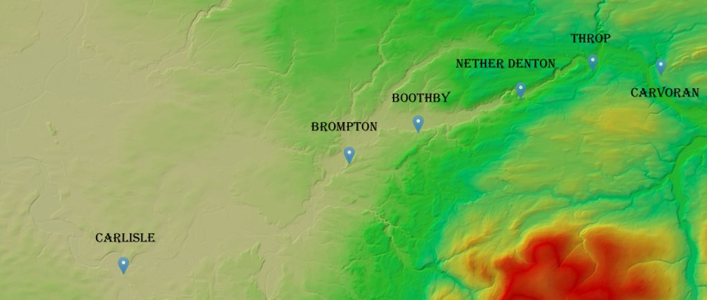
So where is Stanegate, and did it ever connect any Roman forts?
There is no road connection; consequently, they are all connected by the river.
Nether Denton Roman Fort to Throp (2.3 miles / 3.8 km)
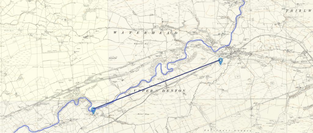
The first signs of the old Stanegate Road on OS maps (not associated with current roads) appear as we move towards the fourth fort, ‘Throp ’-further down the river.

This road is not very well defined in the landscape, with a single ditch (8m) on the North side rather than two ditches on either side. The road is 9m wide, then halves to 4m wide in places.

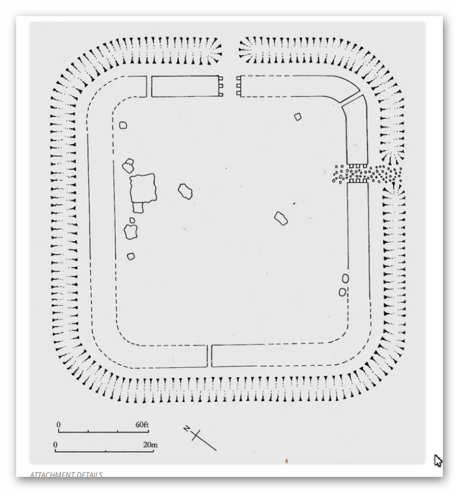
According to the archaeologists, this camp’s exit is obvious (south-east).
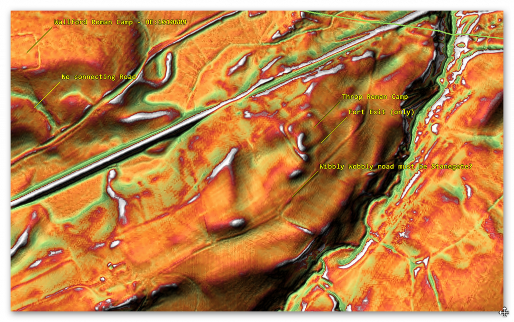
If Throp Fort does indeed join Stanegate – then the road is very ‘wibbly wobbly’ in construction and veers north-east past Throp Fort and into a ravine where it disappears by the Vallum (green line), which also seems to have gone missing.
We also see other Roman camps like Wallford (like the last four Roman sites we have studied) that are next to the River Irthing – but again not connecting to the Stanegate – although the road is only a few hundred metres from the site, according to the OS maps. Moreover, it is more substantial (in size) than Throp; Wallford (626m to the NW) and Crooks (600m to the SE); therefore, has it been misidentified as one of these critical sites of defence??
Consequently, if it was a fallback position and using the River as the border, it was too far away from the River to be effective; therefore, would Wallford (which is on the water) be the preferred fort?
Throp to Carvoran (2.1 miles/3.4 km)
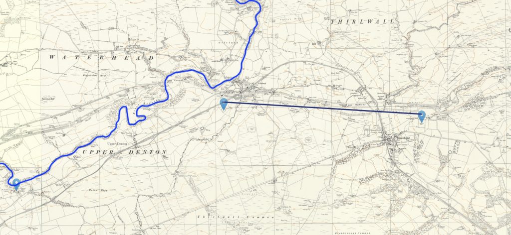
The Stanegate Road that goes to Carvoran from Throp seems to start suddenly at the top of the hill in the region of a quarry – there is no sign of any road in or coming out of the ravine where Throp exists. Interestingly, the Vallum (which is next to and parallel to Stanegate) seems to do the same, indicating this area may have been flooded in the past, including during the Roman period.
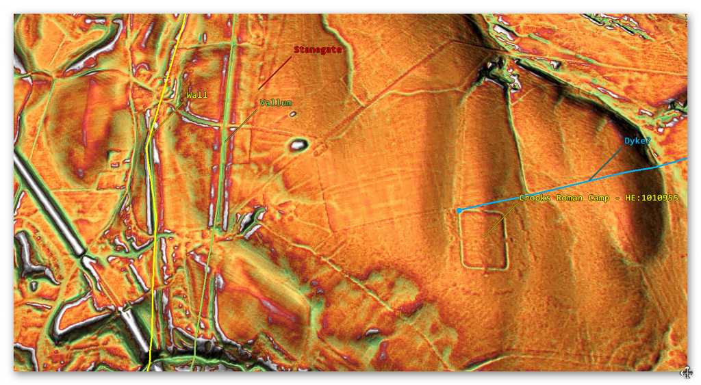
This observation is reinforced by the Roman camp of Crooks, which has no road connections but seems to be connected to a Dyke as it has a double bank on each side of the straight track – which starts in a nearby river valley and ends in the same valley as Stanegate starts?
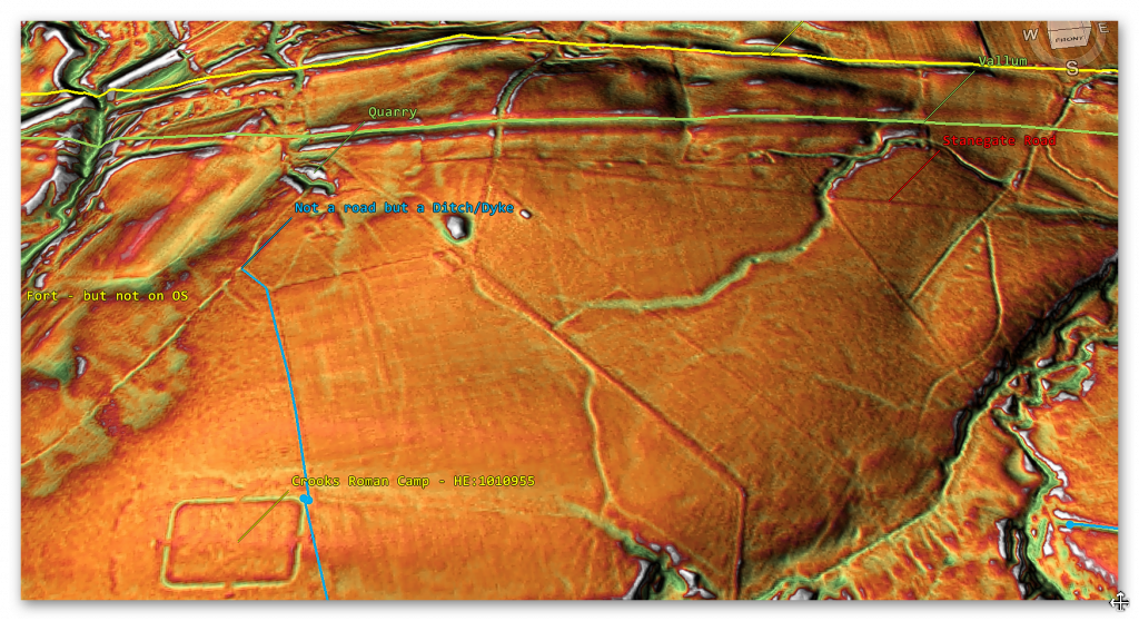
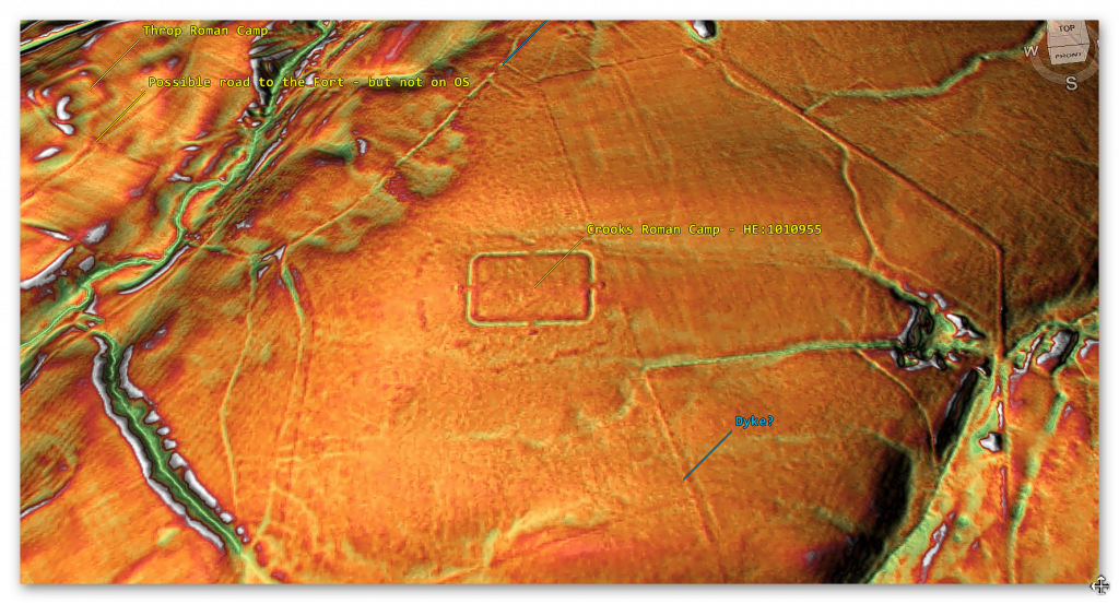
But a clear connection to the Fort is not conclusive, as the road/dyke is at a strange angle, and one would imagine that if the trackway existed at the time of construction, the fort would be built to the exact alignment rather than aligning with the two river valleys in the area?
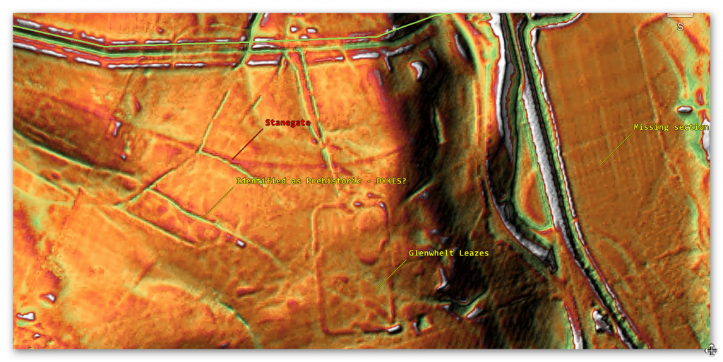
Further down the observable road, we find a Roman Fort that connects to this section of Stanegate – Glenwhelt Leases.
There seems to be a direct connection to Stanegate via a sunken path. This path continues to the Vallum, passing Stanegate – an Historic England Report ‘Haltwhistle Golf Course, Greenhead Carlisle; Glenwhelt Leazes Temporary Camp: Aerial Assessment by Cara Pearce ‘ suggests that the ditches to the WEST of the site are prehistoric in origin (which strangely look like the same size and shape as the ditch going North)?
There is no evidence of Stangate or the road going down the slope to the river or crossing this riven (needs a bridge?), and OS maps show it disappears and reappears just before Carvoran camp.
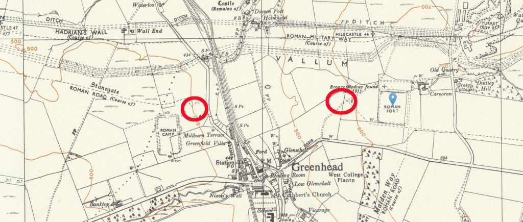
On the other side of the river is Carvoran Roman Fort. The OS map suggests a SE Stanegate meets the Southern aspect of the Fort and then continues east parallel to the fort’s wall until it meets another Roman Road called Maiden Way – sadly, LiDAR proves this is pure speculation!!
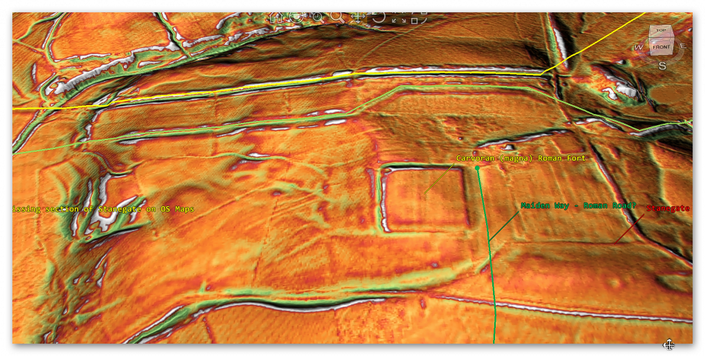
The interesting aspects of Carvoran (something known as ‘Magna’) are that it does not connect to Stanegate or Maiden Way. The only raised walkway is in the NW of the camp and links to the Vallum (again) – as you will see in other case studies, the Vallum (spoiler alert!!) was also used as a roadway
From the LiDAR map, Stanegate appears to come out of the ravine and, via a present-day roadway sunk into the ground (so it could have been another Dyke originally), whose bank was used as a road, and the Stanegate piggybacked onto this prehistoric route?
Carvoran (Magna) to Haltwhistle (3.1 miles / 5km)
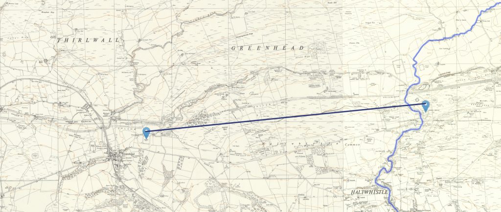
This is the first stretch of Stanegate that is complete and connects two of the supposed defensive forts made for the Stanegate together!!
On this road to Haltwhistle, we notice Stanegate changes character several times.
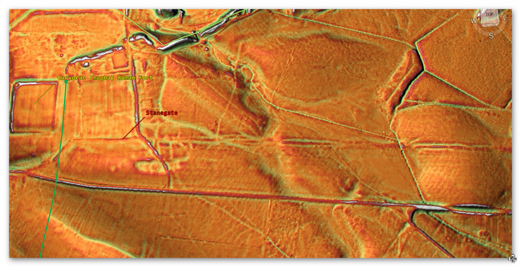
At the start of the road in this section, it is 4m wide with no gutter on each side – but as we reported earlier, “Where it left the base of Corstopitum, the Stanegate was 22 feet (6.7 m) wide with covered stone gutters and a foundation of 6-inch (150 mm) cobbles with 10 inches (250 mm) of gravel on top.” So we are looking at a 7m road that fits the classic description.
So, this section is nearly half the expected size?
A few hundred metres East of this point, the Stanegate turns into a 24m wide road with an 8m central roadway and 8m ditches on both sides – before disappearing into quarries. And these quarries are commonplace on this road – which we will look at more in the essay’s conclusion. Then Stanegate emerges into a broken, dysfunctional construction of no obvious nature.
** End of Extract **
This was an extract from the NEW Book Ancient Prehistoric Canals (Dykes) – Wansdyke, available on Amazon as a FULL COLOUR HARD BACK (£49.95) or an ECONOMY (£9.99) SOFTBACK black and white VERSION – it is also available as a KINDLE (£2.99) book. For further information about our work on Prehistoric Britain visit our WEBSITE or VIDEO CHANNEL.
Product details
- ASIN : B0BN7PD6BS
- Publisher : Independently published (24 Nov. 2022)
- Language : English
- Hardcover : 477 pages
- ISBN-13 : 979-8358524187
- Dimensions : 15.24 x 3.33 x 22.86 cm
- Illustrations: 350+
Author’s Biography

Robert John Langdon, a polymathic luminary, emerges as a writer, historian, and eminent specialist in LiDAR Landscape Archaeology.
His intellectual voyage has been interwoven with stints as an astute scrutineer in government and major corporate bastions, spanning British Telecommunications, Cable and Wireless, British Gas, and the esteemed University of London.
A decade hence, Robert’s transition into retirement unfurled a chapter of insatiable curiosity. He immersed himself in Politics, Archaeology, Philosophy, and the enigmatic realm of Quantum Mechanics. His academic odyssey took him through the venerable corridors of knowledge hubs such as the Museum of London, University College London, Birkbeck College, The City Literature Institute, and Chichester University.
In the symphony of his life, Robert is a custodian of three progeny and a pair of cherished grandchildren. His sanctuary lies ensconced in the embrace of West Wales, where he inhabits an isolated cottage, its windows framing a vista of the boundless sea – a retreat from the scrutinising gaze of Her Majesty’s Revenue and Customs, an amiable clandestinity in the lap of nature.
Exploring Prehistoric Britain: A Journey Through Time
My blog delves into the fascinating mysteries of prehistoric Britain, challenging conventional narratives and offering fresh perspectives grounded in cutting-edge research, particularly LiDAR technology. I invite you to explore some key areas of my research. For example, I re-examine the Wansdyke, often cited as a defensive structure, in light of new evidence. I’ve presented my findings in my blog post Wansdyke: A British Frontier Wall – ‘Debunked’, and a Wansdyke LiDAR Flyover video further visualises my conclusions.
My work also often challenges established archaeological dogma. I argue that many sites, such as Hambledon Hill, commonly identified as Iron Age hillforts, are not what they seem. My posts Lidar Investigation Hambledon Hill – NOT an ‘Iron Age Fort’ and Unmasking the “Iron Age Hillfort” Myth explore these ideas in detail and offer an alternative view. Similarly, I re-evaluated sites like Cissbury Ring and White Sheet Camp through LiDAR analysis in my posts “Lidar Investigation Cissbury Ring through time” and “Lidar Investigation White Sheet Camp,“ revealing fascinating insights into their true purpose. I have also examined South Cadbury Castle, often linked to the mythical Camelot56.
My research also extends to ancient water management, including the role of canals and other linear earthworks. I have discussed the true origins of Car Dyke in multiple posts, including Car Dyke – ABC News Podcast and Lidar Investigation Car Dyke – North Section, which suggest a Mesolithic origin 2357. I also explore the misidentification of Roman aqueducts, as seen in my posts on the Great Chesters (Roman) Aqueduct. My research has also been greatly informed by my post-glacial flooding hypothesis, which has helped explain landscape transformations over time. I have discussed this hypothesis in several posts, including AI now supports my Post-Glacial Flooding Hypothesis and Exploring Britain’s Flooded Past: A Personal Journey
Finally, my blog also investigates prehistoric burial practices, as seen in Prehistoric Burial Practices of Britain and explores the mystery of Pillow Mounds, often mistaken for medieval rabbit warrens, but with a potential link to Bronze Age cremation in my posts: Pillow Mounds: A Bronze Age Legacy of Cremation? and The Mystery of Pillow Mounds: Are They Really Medieval Rabbit Warrens?. My research also includes astronomical insights into ancient sites, for example, in Rediscovering the Winter Solstice: The Original Winter Festival. I also review new information about the construction of Stonehenge in The Stonehenge Enigma.
Yes. I’d make this far tighter, more inviting and more obviously a gateway into the rest of your work. The present version repeats the website several times and reads more like an author biography than a “what next?” section.
I’d also make the three routes immediately obvious: Explore the Research → Watch the Videos → Read the Books, with Facebook as the discussion/community route.
Further Reading — Explore the Evidence
The investigation doesn’t end with this article.
Prehistoric Britain brings together hundreds of articles, LiDAR investigations, field discoveries, archaeological studies and original research exploring Britain’s prehistoric landscape from a different perspective.
Follow the evidence across ancient waterways, lost landscapes, Stonehenge and Avebury, prehistoric engineering, submerged Britain, ancient DNA and the effects of post-glacial flooding — comparing established archaeological interpretations with alternative explanations suggested by the physical evidence.
🎬 Watch the Investigations
Prefer to watch rather than read?
The Robert John Langdon YouTube channel has more than 200 documentaries, investigations, and video presentations that bring the research to life through maps, LiDAR, archaeological evidence, and landscape reconstruction.
Discover investigations including 13 Things That Don’t Make Sense in History, Silbury Avenue – The Lost Stone Avenue, Stonehenge, prehistoric waterways, submerged landscapes and many more.
📚 Explore the Book Library
Go deeper into the evidence through Robert John Langdon’s growing collection of books and specialist studies, including:
- The Stonehenge Hoax – 13 Things That Don’t Make Sense in History
- Car Dyke – Prehistoric Dyke
- Wansdyke – Prehistoric Dyke
- Offa’s Dyke – Prehistoric Dyke
- Silbury Avenue – The Lost Stone Avenue
- The Vallum – At Hadrian’s Wall
- Stonehenge: The World’s First Computer
- Avebury’s Lost Stone Avenue
Many of these investigations connect directly with the evidence discussed throughout the website, allowing individual discoveries to be examined as part of the much wider prehistoric landscape.
🔎 Read the Main Trilogy
Three major works bring together the central strands of the research:
The Post-Glacial Flooding Hypothesis — investigates the evidence for radically different water levels, waterways and landscapes in prehistoric Britain.
The Stonehenge Enigma — re-examines the chronology, landscape and purpose of one of the world’s most famous prehistoric monuments.
Dawn of the Lost Civilisation — explores the evidence for sophisticated communities, technology and maritime connections far earlier than traditionally assumed.
💬 Join the Investigation
New discoveries, LiDAR surveys and research are discussed as they happen in the Prehistoric Britain Facebook Group.
Join the discussion, challenge the evidence, offer alternative interpretations and follow new investigations as they develop.
Don’t just read the accepted story. Explore the evidence, compare the interpretations, and decide for yourself.
Other Blogs
1
a
- Ackling Dyke – Facts and the Archaeological Fiction
- Ackling Dyke – Part II – Puddletown Forest: When a Roman Road Becomes an Assumption
- Ackling Dyke – Part III – The Roman Road Mystery Finally Makes Sense
- AI now Supports – Homo Superior
- AI now supports my Post-Glacial Flooding Hypothesis
- Alexander the Great sailed into India – where no rivers exist today
- Ancient Secrets of Althorp – debunked
- Antler Picks built Ancient Monuments – yet there is no real evidence
- Antonine Wall – Prehistoric Canals (Dykes)
- Archaeological ‘pulp fiction’ – has archaeology turned from science?
- Archaeological Pseudoscience
- Archaeology in the Post-Truth Era
- Archaeology: A Bad Science?
- Archaeology: A Harbour for Fantasists?
- Archaeology: Fact or Fiction?
- Archaeology: The Flaws of Peer Review
- Archaeology’s Bayesian Mistake: Stop Averaging the Past
- Are Raised Beaches Archaeological Pseudoscience?
- Atlantis Found: The Mathematical Proof That Plato’s Lost City Was Doggerland
- ATLANTIS: Discovery with Dan Snow Debunked
- Avebury Ditch – Avebury Phase 2
- Avebury through time
- Avebury’s great mystery revealed
- Avebury’s Lost Stone Avenue – Flipbook
b
- Battlesbury Hill – Wiltshire
- Beyond Stone and Bone: Rethinking the Megalithic Architects of Northern Europe
- BGS Prehistoric River Map
- Blackhenge: Debunking the Media misinterpretation of the Stonehenge Builders
- Brain capacity (Cro-Magnon Man)
- Britain’s First Road – Stonehenge Avenue
- Britain’s Giant Prehistoric Waterways
- British Roman Ports miles away from the coast
c
- Caerfai Promontory Fort – Archaeological Nonsense
- Car Dyke – ABC News PodCast
- Car Dyke – North Section
- Cardigan Bay: The Holocene Evidence the Old Geological Story Has Missed
- CASE STUDY – An Inconvenient TRUTH (Craig Rhos Y Felin)
- Case Study – River Avon
- Case Study – Woodhenge Reconstruction
- Chapter 2 – Craig Rhos-Y-Felin Debunked
- Chapter 2 – Stonehenge Phase I
- Chapter 2 – Variation of the Species
- Chapter 3 – Post Glacial Sea Levels
- Chapter 3 – Stonehenge Phase II
- Chapter 7 – Britain’s Post-Glacial Flooding
- Cissbury Ring through time
- Clement Reid, Doggerland, and the Archaeological Establishment
- Cro-Magnon Brain Capacity
- Cro-Magnon Megalithic Builders: Measurement, Biology, and the DNA
- Cro-Magnons – An Explainer
d
- Darwin’s Children – Flipbook
- Darwin’s Children – The Cro-Magnons
- Dawn of The Lost Civilisation – 1/10
- Dawn of the Lost Civilisation – Flipbook
- Dawn of the Lost Civilisation – Introduction
- Digging for Britain – Cerne Abbas
- Digging for Britain Debunked – Cerne Abbas 2
- Digging Up Britain’s Past – Debunked
- DLC Chapter 1 – The Ascent of Man
- Durrington Walls – Woodhenge through time
- Durrington Walls Revisited: Platforms, Fish Traps, and a Managed Mesolithic Landscape
- Dyke Construction – Hydrology 101
- Dykes Ditches and Earthworks
- DYKES of Britain
e
f
g
h
- Hadrian’s Wall – Military Way Hoax
- Hadrian’s Wall – the Stanegate Hoax
- Hadrian’s Wall Vallum – Prehistoric Canals – FREE Online Book
- Hadrian’s Wall LiDAR investigation
- Hambledon Hill – NOT an ‘Iron Age Fort’
- Hayling Island Lidar Maps
- Hidden Sources of Ancient Dykes: Tracing Underground Groundwater Fractals
- Historic River Avon
- Hollingsbury Camp Brighton – A Hillfort… or a Forgotten Harbour?
- Hollows, Sunken Lanes and Palaeochannels
- Homo Superior – Flipbook
- Homo Superior – History’s Giants
- How Lidar will change Archaeology
- Hydrology 101 Simplified: Why Britain’s Dykes Worked Without Rivers
i
l
m
- Maiden Castle through time
- Mathematics Meets Archaeology: Discovering the Mesolithic Origins of Car Dyke
- Mesolithic River Avon
- Mesolithic Stonehenge
- Minerals found in Prehistoric and Roman Quarries
- Mining in the Prehistoric to Roman Period
- Mount Caburn through time
- Mysteries of the Oldest Boatyard Uncovered
- Mythological Dragons – a non-existent animal that is shared by the World.
o
- Offa’s Dyke Flipbook
- Old Sarum Lidar Map
- Old Sarum Through Time…………….
- On Sunken Lands of the North Sea – Lived the World’s Greatest Civilisation.
- OSL Chronicles: Questioning Time in the Geological Tale of the Avon Valley
- Oswestry LiDAR Survey
- Oswestry through time
- Oysters in Archaeology: Nature’s Ancient Water Filters?
p
- Pillow Mounds: A Bronze Age Legacy of Cremation?
- Pinkery Canal
- Plato Was Right: The Archaeological Evidence the Academics Never Expected
- Post Glacial Flooding – Flipbook
- Prehistoric Burial Practices of Britain
- Prehistoric Canals – Wansdyke
- Prehistoric Canals – Wansdyke
- Prehistoric Canals (Dykes) – Great Chesters Aqueduct (The Vallum Pt. 4)
- Prehistoric Canals (Dykes) – Offa’s Dyke (Chepstow)
- Prehistoric Canals (Dykes) – Offa’s Dyke (LiDAR Survey)
- Prehistoric Canals (Dykes) – Offa’s Dyke Survey (End of Section A)
- Prehistoric Canals (Dykes) – Wansdyke (4)
- Prehistoric Canals Wansdyke 2
- Professor Bonkers and the mad, mad World of Archaeology
r
- Real-World Confirmation of Post-Glacial Flooding
- Rebirth in Stone: Decrypting the Winter Solstice Legacy of Stonehenge
- Rediscovering the Winter Solstice: The Original Winter Festival
- Rethinking Ancient Boundaries: The Vallum and Offa’s Dyke”
- Rethinking Ogham: Could Ireland’s Oldest Script Have Begun as a Tally System?
- Rethinking The Past: Mathematical Proof of Langdon’s Post-Glacial Flooding Hypothesis
- Revolutionising History: Car Dyke Unveiled as Prehistoric & the Launch of FusionBook 360
- Rising Evidence, Falling Rivers: The Real Story of Europe’s First Farmers
- Rivers of the Past Were Higher: A Fresh Perspective on Prehistoric Hydrology
s
- Sea Level Changes
- Section A – NY26SW
- Section B – NY25NE & NY26SE
- Section C – NY35NW
- Section D – NY35NE
- Section E – NY46SW & NY45NW
- Section F – NY46SE & NY45NE
- Section G – NY56SW
- Section H – NY56NE & NY56SE
- Section I – NY66NW
- Section J – NY66NE
- Section K – NY76NW
- Section L – NY76NE
- Section M – NY87SW & NY86NW
- Section N – NY87SE
- Section O – NY97SW & NY96NW
- Section P – NY96NE
- Section Q – NZ06NW
- Section R – NZ06NE
- Section S – NZ16NW
- Section T – NZ16NE
- Section U – NZ26NW & NZ26SW
- Section V – NZ26NE & NZ26SE
- Silbury Avenue – Avebury’s First Stone Avenue
- Silbury Hill
- Silbury Hill / Sanctuary – Avebury Phase 3
- Sky Maps of Prehistoric Britain
- Somerset Plain – Signs of Post-Glacial Flooding
- South Cadbury Castle – Camelot
- Statonbury Camp near Bath – an example of West Wansdyke
- Stone me – the druids are looking the wrong way on Solstice day
- Stone Transportation and Dumb Censorship
- Stonehenge – Monument to the Dead
- Stonehenge Hoax – Dating the Monument
- Stonehenge Hoax – Round Monument?
- Stonehenge Hoax – Summer Solstice
- Stonehenge LiDAR tour
- Stonehenge Phase 1 — Britain’s First Monument
- Stonehenge Phase I (The Stonehenge Landscape)
- Stonehenge Solved – Pythagorean maths put to use 4,000 years before he was born
- Stonehenge Through Time
- Stonehenge, Doggerland and Atlantis connection
- Stonehenge: Borehole Evidence of Post-Glacial Flooding
- Stonehenge: Discovery with Dan Snow Debunked
- Stonehenge: The World’s First Computer – FREE Book
- Stonehenge: The Worlds First Computer
- Stonehenge’s The Lost Circle Revealed – DEBUNKED
- Stonehenge’s Chronological Mirage
t
- Ten Reasons Why Car Dyke Blows Britain’s Earthwork Myths Out of the Water
- Ten Things You Didn’t Know About Britain’s Prehistoric Flooded Past
- Ten thousand year old boats found on Northern Europe’s Hillsides
- Ten thousand-year-old boats found on Northern Europe’s Hillsides
- Testing Plato’s Atlantis Against Reality
- The “Hunter-Gatherer” Myth: Why It’s Time to Bury This Outdated Term
- The Ancient Mariners – Flipbook
- The Ancient Mariners – Prehistoric seafarers of the Mesolithic
- The Ascent of Man — From Survival to Systems
- The Beringian Migration Myth: Why the Peopling of the Americas by Foot is Mathematically and Logistically Impossible
- The Bluestone Enigma
- The Bulford Hoax: The “Simpler, Older Stonehenge” That Wasn’t
- The Cheddar Man Hoax
- The Cro-Magnon Cover-Up: How DNA and PR Labels Erased Our Real Ancestry
- The Dolmen and Long Barrow Connection
- The Durrington Mega-Monument Hoax: What Lies Beneath? – Debunked
- The Durrington Walls Hoax – it’s not a henge?
- The Dyke Myth Collapses: Excavation and Dating Prove Britain’s Great Dykes Are Prehistoric Canals
- The First European Smelted Bronzes
- The Fury of the Past: Natural Disasters in Historical and Prehistoric Britain
- The Giant’s Graves of Cumbria
- The Giants of Prehistory: Cro-Magnon and the Ancient Monuments
- The Great Ancient DNA Illusion: How Statistical Models Became Archaeological “Facts”
- The Great Antler Pick Hoax
- The Great Bell Beaker Migration Myth
- The Great Chichester Hoax – A Bridge too far?
- The Great Dorchester Aqueduct Hoax
- The Great Farming Hoax – (Einkorn Wheat)
- The Great Farming Migration Hoax
- The Great Hadrian’s Wall Hoax
- The Great Iron Age Hill Fort Hoax
- The Great Offa’s Dyke Hoax
- The Great Prehistoric Migration Hoax
- The Great Stone Transportation Hoax
- The Great Stonehenge Hoax
- The Great Wansdyke Hoax
- THE GREAT WEST WOODS HOAX — WHEN ONE STONE BECOMES FIFTY
- The Henge and River Relationship
- The Logistical Impossibility of Defending Maiden Castle
- The Long Barrow and Dolmen Enigma
- The Long Barrow Mystery
- The Long Barrow Mystery: Unravelling Ancient Connections
- The Lost Island of Avalon – revealed
- The Maiden Way Hoax – A Closer Look at an Ancient Road’s Hidden History
- The Maths – LGM total ice volume
- The Mystery of Pillow Mounds: Are They Really Medieval Rabbit Warrens?
- THE ODYSSEY PROBLEM: WHY DID A WEEK-LONG VOYAGE BECOME A TEN-YEAR EPIC?
- The Old Sarum Hoax
- The Oldest Boat Yard in the World found in Wales
- The Perils of Paradigm Shifts: Why Unconventional Hypotheses Get Branded as Pseudoscience
- The Post-Glacial Flooding Hypothesis – 1/11
- The Post-Glacial Flooding Hypothesis – Flipbook
- The Post-Glacial Flooding Theory
- The Problem with Hadrian’s Vallum
- The Rise of the Cro-Magnon (Homo Superior)
- The Roman Military Way Hoax
- The Silbury Hill Lighthouse?
- The Stone Money – Credit System
- The Stonehenge Avenue
- The Stonehenge Avenue
- The Stonehenge Code: Unveiling its 10,000-Year-Old Secret
- The Stonehenge Crescent: A Monument to a Lost World
- The Stonehenge Enigma – Flipbook
- The Stonehenge Enigma: Part 1/6
- The Stonehenge Hoax – Bluestone Quarry Site
- The Stonehenge Hoax – Flipbook
- The Stonehenge Hoax – Moving the Bluestones
- The Stonehenge Hoax – Periglacial Stripes
- The Stonehenge Hoax – Station Stones
- The Stonehenge Hoax – Stonehenge’s Location
- The Stonehenge Hoax – The Ditch
- The Stonehenge Hoax – The Slaughter Stone
- The Stonehenge Hoax – The Stonehenge Layer
- The Stonehenge Hoax – Totem Poles
- The Stonehenge Hoax – Woodhenge
- The Stonehenge Hospital
- The Stonehenge Transportation Mystery
- The Subtropical Britain Hoax
- The Troy, Hyperborea and Atlantis Connection
- The Vallum @ Hadrian’s Wall – it’s Prehistoric!
- The Vallum at Hadrian’s Wall (Summary)
- The Woodhenge Hoax
- Thirty Years of CAU Archaeology Going Nowhere?
- Three Dykes – Kidland Forest
- Thurnam’s 137 Skulls: The Forgotten People Behind Britain’s Megaliths.
- Top Ten Misidentified Fire Beacons in British History
- Troy Debunked – Troy did not exist in Asia Minor, but in fact, the North Sea island of Doggerland
- TSE – DVD Barrows
- TSE DVD – An Inconvenient Truth
- TSE DVD – Antler Picks
- TSE DVD – Avebury
- TSE DVD – Durrington Walls & Woodhenge
- TSE DVD – Dykes
- TSE DVD – Epilogue
- TSE DVD – Stonehenge Phase I
- TSE DVD – Stonehenge Phase II
- TSE DVD – The Post-Glacial Hypothesis
- TSE DVD Introduction
- TSE DVD Old Sarum
- Twigs, Charcoal, and the Death of the Saxon Dyke Myth
w
- Wansdyke – Short Film
- Wansdyke East – Prehistoric Canals
- Wansdyke Flipbook
- Wansdyke LiDAR Flyover
- Wansdyke: A British Frontier Wall – ‘Debunked’
- Was Columbus the first European to reach America?
- What Archaeology Missed Beneath Stonehenge
- White Sheet Camp
- Why a Simple Fence Beats a Massive Dyke (and What That Means for History)
- Windmill Hill – Avebury Phase 1
- Winter Solstice – Science, Propaganda and Indoctrination
- Woodhenge – the World’s First Lighthouse?