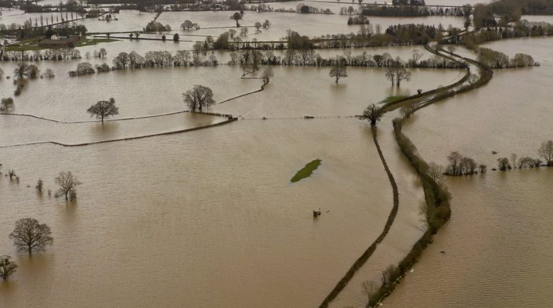
Somerset Plain – Signs of Post-Glacial Flooding
CASE STUDY – Somerset Plain and the annual flooding
Extract from the book ‘The Post-Glacial Flooding Hypothesis”
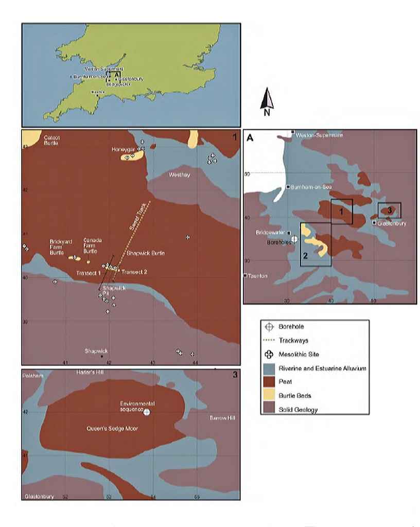
The Somerset Levels encompass a sprawling expanse spanning approximately 160,000 acres (equivalent to 650 square kilometres), crisscrossed by the imposing Polden Hills. These lowlands are divided into distinct sections by this geological feature, with the southern regions drained by the meandering River Parrett, while the flowing waters of the rivers Axe and Brue nourish the northern areas. Serving as a natural demarcation, the majestic Mendip Hills stand as a formidable barrier between the Somerset Levels and their counterpart, the North Somerset Levels.
Within the intricate tapestry of the Somerset Levels, a captivating contrast emerges. The coastal fringes are characterised by marine clay “levels,” seamlessly transitioning into the heart of the landscape, where peat-based “moors” dominate the terrain. This intricate duality defines the very essence of this geographical marvel.
Regarding land utilisation, the Somerset Levels paint a vivid mosaic of agricultural diversity. A significant proportion, around 70 per cent, is meticulously fashioned into lush grasslands, providing a thriving foundation for livestock and cultivation. This verdant expanse stands as a testament to the symbiotic relationship between the land and those who work it.
The remaining portion, etched with thoughtful precision into the fabric of the landscape, serves as a canvas for arable endeavours. Here, the spirit of cultivation finds its voice, yielding many crops that sustain the land and its inhabitants. It’s within these carefully curated plots that the dance of growth and sustenance unfolds, a testament to the skilful mastery of those who tend to the earth’s bounties.
Yet, the Somerset Levels harbour more than just agricultural vitality. They are a realm where nature and commerce intertwine, revealing a unique blend of purpose. Within this tableau, willow and teazel flourish under the sun’s embrace, nurtured not only by nature’s hand but also by the aspirations of commerce. Cultivated with intent, these crops serve as a reminder of humanity’s capacity to harness the land’s resources while respecting its innate rhythms.
Moreover, the Somerset Levels hold hidden treasures beneath their surface. Peat, formed over millennia through the slow decomposition of organic matter, is carefully extracted from this land. Beyond its agricultural role, peat emerges as a valuable resource, providing a glimpse into the earth’s history and contributing to many industrial applications.
In summary, the Somerset Levels are a landscape of complexity and harmony, a symphony composed by the forces of nature and human endeavour. From the captivating dichotomy of “levels” and “moors” to the dance of grasslands and arable fields, this land embodies a mosaic of purpose and beauty. As the rhythms of growth and cultivation intertwine with the pragmatic pursuits of commerce, the Somerset Levels stand as a testament to the remarkable synergy between nature’s bounty and human ingenuity.
Rates of relative sea level rise in Bridgwater Bay (Long et al. 2001)
| Phase | Cal. BC | MSL rise (m) | Ave. Rate mm yr-1 |
| 1 | 7500 – 5500 | -25 to -10 | 7.5mm |
| 2 | 5500 – 4000 | -10 to -5 | 3.3 |
| 3 | 4000- 0 AD/BC | -5 to -2 | 0.6 |
If Long et al., rates are correct, then we are looking at potential discharge rates from rivers 1250% greater in early Mesolithic to the Iron Age, which is comparable to the discharge rates of the Thames during the early Holocene. During these periods of maximum flow (as we saw with the Thames case study) the flood plain is covered with water. Reeds and other plant life cannot grow until the discharge rate reduces narrowing the river creating a ‘braided’ or bend in the river so that sediment builds up to become marshland growth. Once this has been established with the annual death and renewal, the area by the river becomes peatland and bog over the centuries.
We can see this evolution in the sediment analysis, as clay and silt foundations, followed by peat and if flooded again, by another layer of silt and reintroduction of peat. As we can radiocarbon-date the peat, we can use this to date the sequences of the river over time.
Porlock Bay
Extensive coring on Porlock Marsh in 1995 revealed up to 10 metres of sediments (silts, sands and peats), dating from c.6700 cal BC when mean sea levels may have been around 8m lower than the present day
The main peat layer at Porlock formed is between c.4500 cal BC and c.3540 cal BC after which it was overlain by deposits of sand, grit, silt and clay (Jennings et al. 1998). This indicates that rivers were active since the LGM and continued until 4500 BC when the river discharge reduced, allowing peat to form at its edges and previous flood plain.
Minehead Bay
Three periods of peat deposition were identified on the present foreshore at Minehead (Jones et al. 2005). The earliest deposits were created in marginal marsh conditions around 5,000 cal BC and an alder carr peat sometime between 5,400 and 5,000 cal BC. There was then another gap of several hundred years until peats were laid down in a mixture of upper saltmarsh, freshwater reed swamp and alder carr environments created sometime between c.4800-4500 cal BC
Parrett Valley
Very little dating and analysis have been carried out in this area. Around the mouth of the Parrett between Stolford and the Poldens Heyworth. Kidson (1976) recorded the Middle Somerset Levels Formation, as intercalated peat and clay along the coast and as a thick peat layer further inland – which deposition beginning around 4,000 cal BC. The Middle Somerset Levels Formation exists as a thick peat layer in the central Parrett valley, which has been briefly characterised by Alderton (1983) and has been dated on its base at Sutton Hams to c.3900 cal BC (Coles and Dobson 1989).
Further inland near Langport, recent evidence has dated the base of the Formation to 4840-4520 cal BC (Wilkinson, 2006). This limited evidence suggests that the organic deposits of the Formation, developed seawards over several hundred years in the 5th-millennium cal BC.
Shapwick
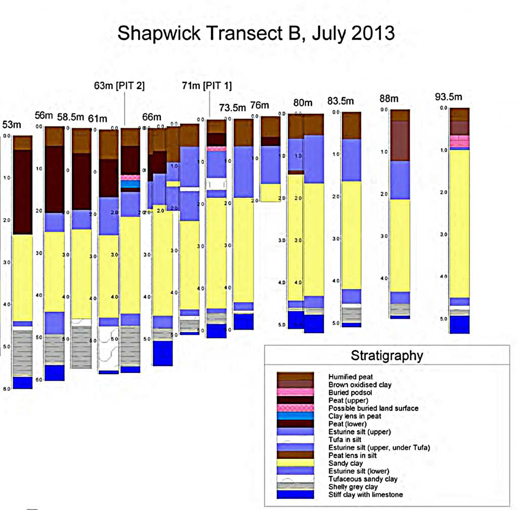
Wilkinson (1998a) published stratigraphic work between Shapwick Burtle and the edge of the Polden Hills. A 7m core (borehole A) has provided a date of 5710–5530 BC (OxA11230) for the base of the lower peat. Borehole A is the first long Holocene pollen sequence to be dated for Shapwick Heath (Tinsley 2002), though it does not extend as far back as those for Minehead and Porlock on the west Somerset coast.
Glastonbury
Sometime around 4600–4200 cal BC, a change from estuarine silts to mostly freshwater peat (the upper peat) took place due to reduced marine influence (negative sea-level tendency). The age range given above is based on a variety of radiocarbon dates for the peat/clay junction, at several places in the central Brue valley.
Table 6 – Peat C14 dating samples for Somerset
| Interpretation | Age Cal. BC | RC Years BP | Lab. Code | Site Reference |
| Base Peat 1 | 5670 – 5380 | 6600 +/- 70 | WK-5311 | Minehead (Jones et al.,2005) |
| Base Peat 2 | 5640 – 5370 | 6570 +/- 70 | WK-5310 | |
| Top Peat 1 | 5620 – 5310 | 6490 +/- 80 | WK-5309 | |
| Base Peat 3 | 5540 – 5290 | 6440 +/- 70 | WK-5308 | |
| Base Alder Peat | 5630 – 5380 | 6560 +/- 60 | WK-5302 | |
| Base Alder Peat | 4830 – 4490 | 5810 +/- 80 | WK-5304 | |
| Top Alder Peat | 4830 – 4520 | 5820 +/- 60 | WK-5303 | |
| Base Site 45 | 4780 – 4460 | 5770 +/- 70 | WK-5305 | |
| Base Site 46 | 4710 – 4360 | 5700 +/- 70 | WK-5306 | |
| Base Peat | 4720 – 4250 | 5620 +/- 100 | HAR-8546 | Brean Down (Bell, 1990) |
| Base 4th Peat | 4235 – 3800 | 5210 +/- 80 | Beta-142355 | Brean-Wedmore (Haslett et al., 2001) |
| Forest Bed | 6609 – 6425 | 7730 +/- 50 | Beta-81655 | Porlock Bay (Jennings et al.,1998) |
| Peat | 6380 – 5970 | 7280 +/- 90 | OxA – 6570 | |
| Top 2nd Peat | 5941 – 5540 | 6870 +/- 90 | Beta-61544 | |
| Top 2nd Peat | 5987 – 5777 | 6707 +/- 50 | Beta- 86775 | |
| Base 4th Peat | 4340 – 3970 | 5290 +/- 75 | OxA – 6572 | |
| Base 4th Peat | 4460 – 4040 | 5450 +/- 70 | OxA – 6569 | |
| Base 4th Peat | 4500 – 4240 | 5515 +/- 65 | OxA – 6571 | |
| Base 4th Peat | 4458 – 3882 | 5250 +/- 180 | Beta- 61542 | |
| Top 4th Peat | 3940 – 3540 | 4925 +/- 60 | OxA – 6402 | |
| Top 4th Peat | 4040 – 3790 | 5120 +/- 55 | OxA – 6399 | |
| Top 4th Peat | 4240 – 3700 | 5160 +/- 100 | OxA – 6401 | |
| Top 4th Peat | 4225 – 3705 | 5140 +/- 100 | Beta-61543 | |
| Base of Middle – Somerset Levels Formation Peat | 3625 – 3195 | 4640 +/- 60 | Beta-142361 | Brean-Wedmore (Haslett et al., 2001) |
| 4335 – 4050 | 5370 +/- 50 | Beta-142353 | ||
| 4235 – 3800 | 5210 +/- 80 | Beta-112355 | ||
| Bulk Sample (c) | 5440 – 5080 | 6340 +/- 70 | WK – 5298 | Burnham-on-Sea (Druca, 1998) |
| Base of Peat (b) | 4660 – 4340 | 5590 +/- 90 | WK – 5297 | |
| Base of Peat (a) | 4360 – 4000 | 5299 +/- 70 | WK – 5299 | |
| Top of Peat (a) | 3780 – 3370 | 4790 +/- 70 | WK – 5300 | |
| Base Peat | 3603 – 3094 | 4670 +/- 60 | WK – 9019 | Walpole (Hollinrake, 2001) |
| Top Peat | 4672 – 4245 | 5580 +/- 160 | WK – 9020 | |
| Lowest Peat | 5990 – 5790 | 6994 +/- 30 | WK – 25711 | |
| Base Peat 3 | 4330 – 4040 | 5345 +/- 37 | WK – 27346 | |
| Base Peat | 4781 – 4370 | 5750 +/- 80 | WK – 9021 | |
| Base Peat below peat layer | 4770 -4460 | 5745 +/- 45 | OxA – 11233 | Shapwick Burtle (Wilkinson, 1999) |
| Base Peat – Sutton Hams | 3970 – 3660 | 5020 +/- 80 | HAR – 5354 | Central Brue Valley (Coles & Dobson, 1989) |
| Base Peat Shapwick Heath | 4611 – 4046 | 5510 +/- 120 | Q- 423 | |
| Base Peat Eclipse Track | 4448 – 4055 | 5440 +/- 70 | HAR – 4865 | |
| Base Peat Meane Village East | 4315 – 3964 | 5270 +/- 70 | HAR – 7064 | |
| Base Peat Walton Heath | 4680 – 4350 | 5650 +/- 70 | Har – 1831 |
Somerset Levels and Moors
The earliest (lowest) fills were studied from boreholes in the coastal area. The earliest dated deposits are from wood fen peat in deep channels (to c.20m below OD) at Highbridge. These peats formed between about 7000 and 7900 cal BC (Heyworth and Kidson 1982). Younger peat beds dating from around 4–5000 cal BC, can be seen at low tide at Burnham-on-Sea (Druce 1998), Stolford (Heyworth 1985) and Brean Down (Bell 1990).
As shown from previous examples, the marshes and bogs do not exist for the first 2000 to 4000 years after the meltwater is released as the rivers are high and fast-moving. But after this period, as the rivers shrank due to discharge volumes dropping, leaving the flood plains that are ideal for the growth of plants and reeds. Consequently, creating over time the formation of marshes and peat bogs. These bogs were suitable for farmers to grow crops and raise animals, in later Bronze and Iron Ages, as they were rich in nitrogen.
The River Siger – (Brown et al., 2014)
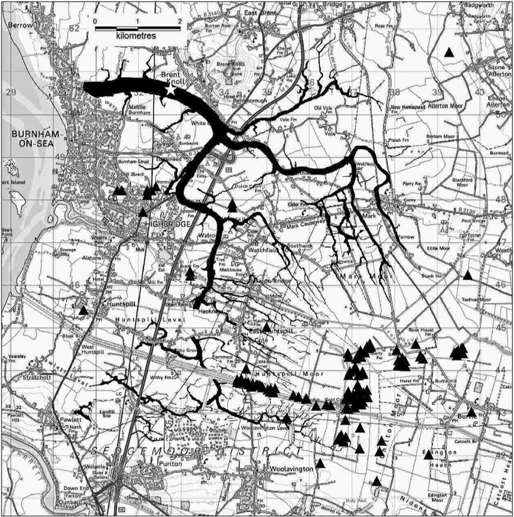
If our hypothesis is correct, then the Somerset Flats would have needed a substantial river running through the area that took the meltwater to the sea and flooded the levels on occasions rather than having the sea inundate the area as current theories suggest.
The relative sea-level history of the Bristol Channel and the inherited topography of the Parrett, Brue and Axe river valleys has produced a 10-15 m deep belt of transgressive estuarine silts and clays interleaving inland with regressive high intertidal terrestrial peats (Allen, 2000).
The processes of transgressive and regressive marine inundation are not fully understood, and as a result, palaeogeography has to be generalised. This is particularly true of the Early Holocene (lower clay) and the Late Holocene inundations of the Somerset Levels broadly resulting from relative sea-level rise coupled with secondary mechanisms including changes in storminess, tidal amplitude and sediment compaction.
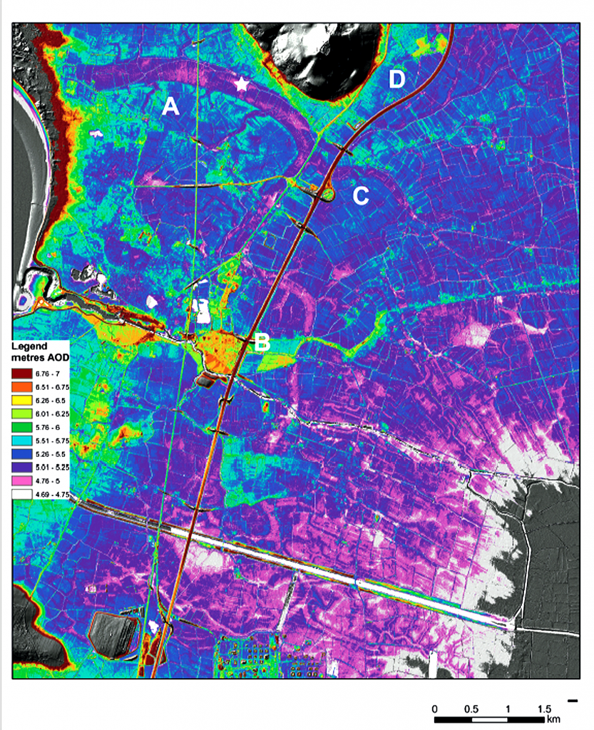
The LiDAR survey clearly shows the composite nature of the network. The elements are Edithmead meander (Fig. 43, A) which has a width of 40-60 m and a meander radius of 3.13 km which would give an approximate length of 6 km, two major tributary systems (Fig.43, B and C) and one minor tributary system (Fig. 43, D).
From the dating of the deepest borehole and its basal depth (below -10 m O.D. and probably c. -17-30 m O.D.), the formation of the Siger channel is likely to be Early Holocene c. 10,000-8,000 BP initially with river flow from the Brue Valley being one of the conduits for net landward sediment influx over the last 9,000 years, supporting our hypotheses that the Somerset Levels flooded as a consequence of meltwater and river activity rather than any form of marine inundation.
For more information about British Prehistory and other articles/books, go to our BLOG WEBSITE for daily updates or our VIDEO CHANNEL for interactive media and documentaries. The TRILOGY of books that ‘changed history’ can be found with chapter extracts at DAWN OF THE LOST CIVILISATION, THE STONEHENGE ENIGMA and THE POST-GLACIAL FLOODING HYPOTHESIS. Other associated books are also available such as 13 THINGS THAT DON’T MAKE SENSE IN HISTORY and other ‘short’ budget priced books can be found on our AUTHOR SITE. For active discussion on the findings of the TRILOGY and recent LiDAR investigations that is published on our WEBSITE you can join our FACEBOOK GROUP.

