The Stonehenge Hoax – Station Stones
Contents
Conundrum 10 – Station Stones – extract from The Stonehenge Hoax Book
Was it an astronomical observatory?
The Problem
In recent years the idea of Stonehenge as an astronomical observation point has become very popular with the ‘new age’ cult that looks at the stones as a ‘magical’ monument rather than a practical, functional site as the archaeologists fail to identify the exact reason and purpose successfully was built. So these ‘ideas’ have flourished to fill the void created by the ‘experts’ as they stutter for explanations. Within this new age, the theory is the Station stones’ role that seems to line up with more astrological occurrences than the leading site.
The Solution
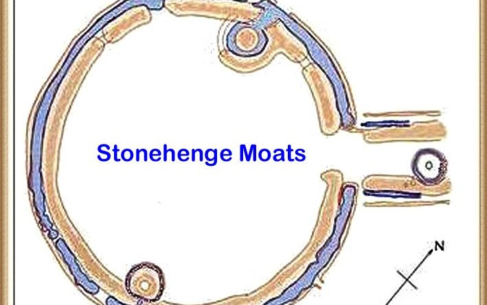
The two Station Stone features found on the Stonehenge site are situated on the North West and South East side of the main monument within the ditched circle – both have individual moats surrounding them. This can be seen clearly in the Station Stone in the North West, also known as WA3595 (North Mount), discovered in 1956 (Atkinson et al.,1956). Where Atkinson observed that ‘a small gully running East-West appears to lie beneath the rubble and earth bank’.
This indicates that the gully was a connecting strip, linking the main henge moat to a smaller moat surrounding the North West Station Stone. It wouldn’t be an unrealistic suggestion that the southern Station Stone was also connected to the main moat. If we believe traditional archaeologists’ commonly held view that the moat surrounding the central monument at Stonehenge was constructed purely as a landscape feature, why would our ancestors connect the two smaller ditches to the main one?
The heel stone also has a ditch indicating its significance. This ditch is almost bisecting the avenue ditch, which would have also been full of water. These ditches are invisible today as they were filled in long ago when the water left the site – but if the Moat and channels were not for water but symbolic purposes, why were they left to fill with soil and disappear from view – it makes no sense unless they are water features that have dried up over the years as the water table has now fallen by 30 metres?
Hawley and Atkinson, both suggested that they were built at the same time “The ditches of the North and South Barrows are suggested as belonging to this phase (Phase 3b) purely on their resemblance to the Heel stone ditch, an observation made by Professor Atkinson(1978,78).” (Cleal et al., 1995,274).
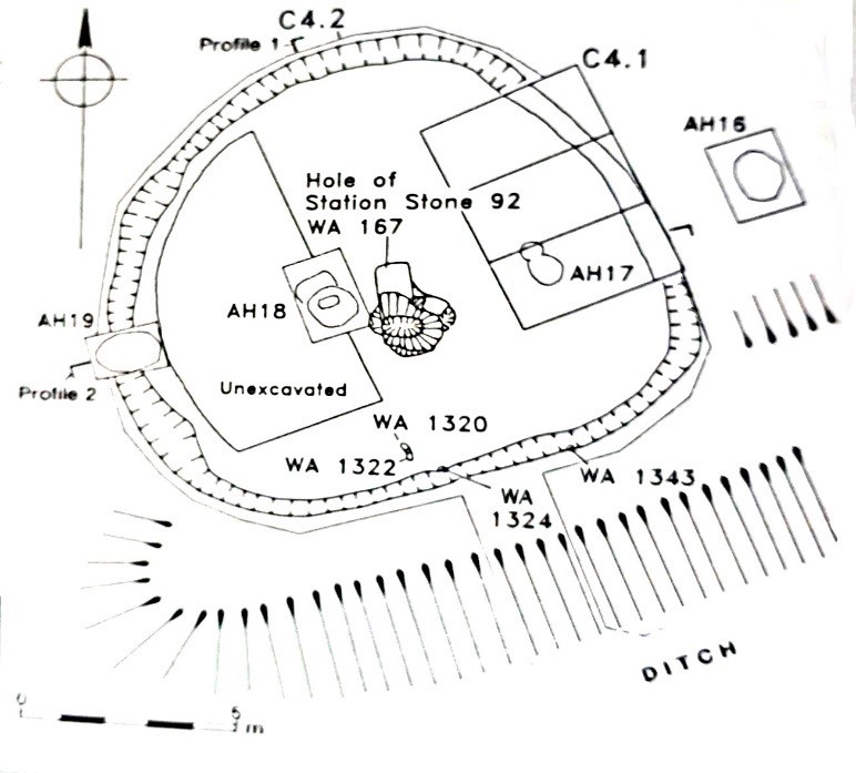
The North and South Station stones and the Heel stone ditches are of considerable depth 1 – 1.2m deep. Symbolic ditches are needed only to cut the surface to meet their requirements. These ditches are full of ‘silt’ or ‘marl’ in all cases. Moreover, it is possible that the same clay liner was added to these features as the excavation reports various anomalies that are unexplained and what I see as evidence of water in the ditches. “There were about 18 inches of dirty chalk upon the bottom… between this, and the humus is a layer of humus with flint single… apart of a decayed horn pick and some flint chips were found on the bottom silt” Hawley (Cleal et al.,1995,278).
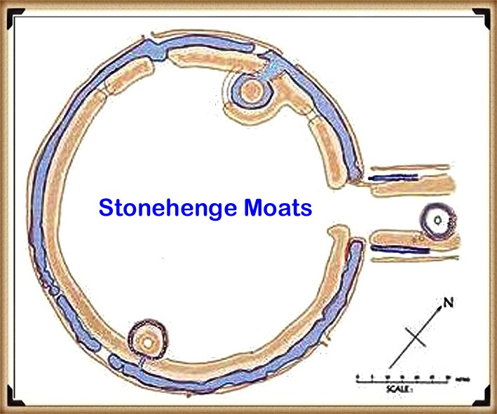
In his 1979 – 80 (C91) excavation, Pitts also found this water deposit, where he observed “chalk intermixed with periglacial marl which covers all of the bottom and moat of the sides…. Natural silting of the greater part of the ditch is acceptable” – this indicates that this was left to silt over time and only filled when the Avenue fell into disuse and the original stones were moved.
At the end of the Neolithic Period, the groundwater had subsided to almost their present levels. Since the great Ice Age melt, the large river that had existed at Stonehenge’s bottom for 5,000 years was gone. The groundwater that once covered the land had moved to the surrounding seas and channels, flooding the island once called Doggerland and leaving it 30 metres under the sea. The moat had dried up at Stonehenge, and consequently, the tools used to clean out the moat in the past (antler picks) were left where they broke in the ditch. Sadly, archaeologists currently take these tools as the basis for their incorrect dating of the site, not when the monument was at the height of its power, but when it was last used as a monument to the dead.
The Station Stones (with mounds) seem to have been added later in the site’s development. This can be seen as the introduction of the Station Stones would have obscured the Aubrey post holes; therefore, they must post-date the original Bluestone circle but predate the infilled moat, as they have moats of their own. We currently don’t know whether the knowledge of the tides was no longer necessary or if the station posts held another particular purpose.
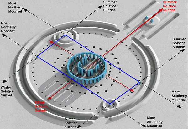
Modern theories use astroarchaeology alignments based on these posts to speculate on the reasons for their existence. Unfortunately, only two of the four Station Stones have a mound and moats, which does not make sense if they are as crucial as these theorists believe. Our ancestors-built round barrows as signposts, not burial mounds. These markers are aligned to show where to go and, more importantly, how to get home.
If you lived in the countryside or became a fell-walker in the days before GPS and OS maps, you used to rely on points on the horizon for guidance. A prehistoric person would have used the same simple principle to get from A to B without getting lost. Initially, these features would have been on islands, as people used boats to transport themselves and trade. Then, as the groundwater fell, they would have used barrows as markers on the horizon to walk from point to point. We still see milestones today on the side of roads; barrows were the milestones for prehistoric societies.
If you follow the line from the centre of the site through the Northern Station Stone, you will go past no less than five long barrows, 15 round barrows, Casterley Camp, Knap Hill Camp, and the White Horse, finally arriving at Avebury. This is not bad, for just 36.4 km of travel. That’s one barrow every 500 metres; not even I could get lost with that marker frequency. Mathematically, the chance of this number of barrows being in line over such a small distance is less than half of one per cent (0.05 %), or 2000 to 1 in layman’s terms.
The Southern Station Stone points the way to Old Sarum near Salisbury. Although it is famous for being the site of the original Salisbury Cathedral, archaeologists have also found evidence of flint tools dating back to 3000 BC. We believe that there is a clear indication that Old Sarum was first used in the Mesolithic Period when it was an island above the raised groundwater level and that (as in many cases) later sites were built upon the location of this original construction.
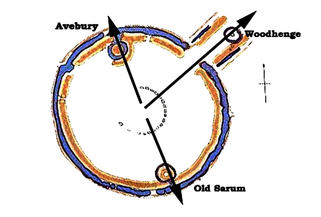
The most interesting of all the original markers at Stonehenge must be the Heel Stone. The Heel Stone is slightly right of centre in the Avenue and, like two of the Station Stones, it has its moat. If we line ourselves up with the Heel Stone from the centre of Stonehenge, it aligns with Durrington Walls and Woodhenge. These three places would have been not only essential neighbouring sites to Stonehenge but a gateway to other sites and trading places in the ancient world. Next to each of the moated Station Stones, a gap was left in the Moat to allow people to cross by the stone in the direction it indicated. This no doubt led the walker along a path, now lost to us 5,000 years later, via a system of barrows, to the desired location.
Unearth the Astonishing Secrets of Stonehenge (The Stonehenge Hoax)
Introduction
Video
Synopsys
Stonehenge, a timeless enigma etched in stone and earth, has stood as a formidable puzzle challenging the intellects of archaeologists and historians alike. Despite the myriad attempts, including books, TV programs, and academic conferences, the secrets of these ancient stones and their encircling ditches have proven elusive. Against this backdrop, we scrutinise the existing thirteen hypotheses, each presenting its narrative but collectively lacking a coherent thread.
In adopting the deductive reasoning akin to Sherlock Holmes, we endeavour to weave these disparate threads into a unified tapestry that not only unravels the mystery of Stonehenge but also shakes the foundations of established academic narratives. This intellectual journey may induce some discomfort as we challenge conventional perceptions and invite a reevaluation of our understanding of the past. Apologies are extended in advance for any cognitive dissonance, but the pursuit of truth and reason mandates an unfiltered presentation of the facts.
So, fasten your seatbelts for an expedition into the archaeological unknown.
As we navigate this intellectual rollercoaster, be prepared for a revelation that might reshape our understanding of Stonehenge and question the foundations of our historical narratives. The dawn of a new archaeological era awaits promising insights that could leave even the most curious minds astonished. As we delve into this intellectual rabbit hole, be ready for a revelation that could make Alice astonished. (The Stonehenge Hoax)
Robert John Langdon (2023) – (The Stonehenge Hoax)
The Journey
Langdon’s journey was marked by meticulous mapping and years of research, culminating in a hypothesis that would reshape our understanding of prehistoric Britain. He proposed that much of the British Isles had once been submerged in the aftermath of the last ice age, with these ancient sites strategically positioned along the ancient shorelines. His groundbreaking maps offered a fresh perspective, suggesting that Avebury had functioned as a bustling trading hub for our ancient ancestors. This audacious theory challenged the prevailing notion that prehistoric societies were isolated and disconnected, instead highlighting their sophistication in trade and commerce.
In the realm of historical discovery, the audacious thinkers, the mavericks who dare to question established narratives, propel our understanding forward. Robert John Langdon is undeniably one of these thinkers. With a deep passion for history and an unyielding commitment to his research, he has unearthed a hidden chapter in the story of Avebury that transcends the boundaries of time and offers fresh insights into our shared human history.
As Langdon’s trilogy, ‘The Stonehenge Enigma,’ continues to explore these groundbreaking theories, it beckons us to embark on a journey of discovery, to challenge our assumptions, and to embrace the possibility that the past is far more complex and interconnected than we ever imagined. With its ancient stones and enigmatic avenues, Avebury continues to whisper its secrets to those who dare to listen, inviting us to see history through a new lens—one illuminated by the audacious vision of Robert John Langdon.
(The Stonehenge Hoax)
The Book
Further Reading
For information about British Prehistory, visit www.prehistoric-britain.co.uk for the most extensive archaeology blogs and investigations collection, including modern LiDAR reports. This site also includes extracts and articles from the Robert John Langdon Trilogy about Britain in the Prehistoric period, including titles such as The Stonehenge Enigma, Dawn of the Lost Civilisation and the ultimate proof of Post Glacial Flooding and the landscape we see today. (AI now Supports – Homo Superior)
Robert John Langdon has also created a YouTube web channel with over 100 investigations and video documentaries to support his classic trilogy (Prehistoric Britain). He has also released a collection of strange coincidences that he calls ‘13 Things that Don’t Make Sense in History’ and his recent discovery of a lost Stone Avenue at Avebury in Wiltshire called ‘Silbury Avenue – the Lost Stone Avenue’.
(AI now Supports – Homo Superior)
Langdon has also produced a series of ‘shorts’, which are extracts from his main body of books:
Other Blogs
1
a
- AI now Supports – Homo Superior
- AI now supports my Post-Glacial Flooding Hypothesis
- Alexander the Great sailed into India – where no rivers exist today
- Ancient Prehistoric Canals – The Vallum
- Ancient Secrets of Althorp – debunked
- Antler Picks built Ancient Monuments – yet there is no real evidence
- Antonine Wall – Prehistoric Canals (Dykes)
- Archaeological ‘pulp fiction’ – has archaeology turned from science?
- Archaeological Pseudoscience
- Archaeology in the Post-Truth Era
- Archaeology: A Bad Science?
- Archaeology: A Harbour for Fantasists?
- Archaeology: Fact or Fiction?
- Archaeology: The Flaws of Peer Review
- Archaeology’s Bayesian Mistake: Stop Averaging the Past
- Are Raised Beaches Archaeological Pseudoscience?
- Atlantis Found: The Mathematical Proof That Plato’s Lost City Was Doggerland
- ATLANTIS: Discovery with Dan Snow Debunked
- Avebury Ditch – Avebury Phase 2
- Avebury Post-Glacial Flooding
- Avebury through time
- Avebury’s great mystery revealed
- Avebury’s Lost Stone Avenue – Flipbook
b
- Battlesbury Hill – Wiltshire
- Beyond Stone and Bone: Rethinking the Megalithic Architects of Northern Europe
- BGS Prehistoric River Map
- Blackhenge: Debunking the Media misinterpretation of the Stonehenge Builders
- Brain capacity (Cro-Magnon Man)
- Brain capacity (Cro-Magnon Man)
- Britain’s First Road – Stonehenge Avenue
- Britain’s Giant Prehistoric Waterways
- British Roman Ports miles away from the coast
c
- Caerfai Promontory Fort – Archaeological Nonsense
- Car Dyke – ABC News PodCast
- Car Dyke – North Section
- CASE STUDY – An Inconvenient TRUTH (Craig Rhos Y Felin)
- Case Study – River Avon
- Case Study – Woodhenge Reconstruction
- Chapter 2 – Craig Rhos-Y-Felin Debunked
- Chapter 2 – Stonehenge Phase I
- Chapter 2 – Variation of the Species
- Chapter 3 – Post Glacial Sea Levels
- Chapter 3 – Stonehenge Phase II
- Chapter 7 – Britain’s Post-Glacial Flooding
- Cissbury Ring through time
- Cro-Magnon Megalithic Builders: Measurement, Biology, and the DNA
- Cro-Magnons – An Explainer
d
- Darwin’s Children – Flipbook
- Darwin’s Children – The Cro-Magnons
- Dawn of the Lost Civilisation – Flipbook
- Dawn of the Lost Civilisation – Introduction
- Digging for Britain – Cerne Abbas 1 of 2
- Digging for Britain Debunked – Cerne Abbas 2
- Digging Up Britain’s Past – Debunked
- DLC Chapter 1 – The Ascent of Man
- Durrington Walls – Woodhenge through time
- Durrington Walls Revisited: Platforms, Fish Traps, and a Managed Mesolithic Landscape
- Dyke Construction – Hydrology 101
- Dykes Ditches and Earthworks
- DYKES of Britain
e
f
g
h
- Hadrian’s Wall – Military Way Hoax
- Hadrian’s Wall – the Stanegate Hoax
- Hadrian’s Wall LiDAR investigation
- Hambledon Hill – NOT an ‘Iron Age Fort’
- Hayling Island Lidar Maps
- Hidden Sources of Ancient Dykes: Tracing Underground Groundwater Fractals
- Historic River Avon
- Hollingsbury Camp Brighton
- Hollows, Sunken Lanes and Palaeochannels
- Homo Superior – Flipbook
- Homo Superior – History’s Giants
- How Lidar will change Archaeology
i
l
m
- Maiden Castle through time
- Mathematics Meets Archaeology: Discovering the Mesolithic Origins of Car Dyke
- Mesolithic River Avon
- Mesolithic Stonehenge
- Minerals found in Prehistoric and Roman Quarries
- Mining in the Prehistoric to Roman Period
- Mount Caburn through time
- Mysteries of the Oldest Boatyard Uncovered
- Mythological Dragons – a non-existent animal that is shared by the World.
o
- Offa’s Dyke Flipbook
- Old Sarum Lidar Map
- Old Sarum Through Time…………….
- On Sunken Lands of the North Sea – Lived the World’s Greatest Civilisation.
- OSL Chronicles: Questioning Time in the Geological Tale of the Avon Valley
- Oswestry LiDAR Survey
- Oswestry through time
- Oysters in Archaeology: Nature’s Ancient Water Filters?
p
- Pillow Mounds: A Bronze Age Legacy of Cremation?
- Post Glacial Flooding – Flipbook
- Prehistoric Burial Practices of Britain
- Prehistoric Canals – Wansdyke
- Prehistoric Canals – Wansdyke
- Prehistoric Canals (Dykes) – Great Chesters Aqueduct (The Vallum Pt. 4)
- Prehistoric Canals (Dykes) – Hadrian’s Wall Vallum (pt 1)
- Prehistoric Canals (Dykes) – Offa’s Dyke (Chepstow)
- Prehistoric Canals (Dykes) – Offa’s Dyke (LiDAR Survey)
- Prehistoric Canals (Dykes) – Offa’s Dyke Survey (End of Section A)
- Prehistoric Canals (Dykes) – Wansdyke (4)
- Prehistoric Canals Wansdyke 2
- Professor Bonkers and the mad, mad World of Archaeology
r
- Rebirth in Stone: Decrypting the Winter Solstice Legacy of Stonehenge
- Rediscovering the Winter Solstice: The Original Winter Festival
- Rethinking Ancient Boundaries: The Vallum and Offa’s Dyke”
- Rethinking Ogham: Could Ireland’s Oldest Script Have Begun as a Tally System?
- Rethinking The Past: Mathematical Proof of Langdon’s Post-Glacial Flooding Hypothesis
- Revolutionising History: Car Dyke Unveiled as Prehistoric & the Launch of FusionBook 360
- Rising Evidence, Falling Rivers: The Real Story of Europe’s First Farmers
- Rivers of the Past Were Higher: A Fresh Perspective on Prehistoric Hydrology
s
- Sea Level Changes
- Section A – NY26SW
- Section B – NY25NE & NY26SE
- Section C – NY35NW
- Section D – NY35NE
- Section E – NY46SW & NY45NW
- Section F – NY46SE & NY45NE
- Section G – NY56SW
- Section H – NY56NE & NY56SE
- Section I – NY66NW
- Section J – NY66NE
- Section K – NY76NW
- Section L – NY76NE
- Section M – NY87SW & NY86NW
- Section N – NY87SE
- Section O – NY97SW & NY96NW
- Section P – NY96NE
- Section Q – NZ06NW
- Section R – NZ06NE
- Section S – NZ16NW
- Section T – NZ16NE
- Section U – NZ26NW & NZ26SW
- Section V – NZ26NE & NZ26SE
- Silbury Avenue – Avebury’s First Stone Avenue
- Silbury Hill
- Silbury Hill / Sanctuary – Avebury Phase 3
- Somerset Plain – Signs of Post-Glacial Flooding
- South Cadbury Castle – Camelot
- Statonbury Camp near Bath – an example of West Wansdyke
- Stone me – the druids are looking the wrong way on Solstice day
- Stone Money – Credit System
- Stone Transportation and Dumb Censorship
- Stonehenge – Monument to the Dead
- Stonehenge Hoax – Dating the Monument
- Stonehenge Hoax – Round Monument?
- Stonehenge Hoax – Summer Solstice
- Stonehenge LiDAR tour
- Stonehenge Phase 1 — Britain’s First Monument
- Stonehenge Phase I (The Stonehenge Landscape)
- Stonehenge Solved – Pythagorean maths put to use 4,000 years before he was born
- Stonehenge Stone Transportation
- Stonehenge Through Time
- Stonehenge, Doggerland and Atlantis connection
- Stonehenge: Discovery with Dan Snow Debunked
- Stonehenge: The Worlds First Computer
- Stonehenge’s The Lost Circle Revealed – DEBUNKED
t
- Ten Reasons Why Car Dyke Blows Britain’s Earthwork Myths Out of the Water
- Ten Things You Didn’t Know About Britain’s Prehistoric Flooded Past
- Ten thousand year old boats found on Northern Europe’s Hillsides
- Ten thousand-year-old boats found on Northern Europe’s Hillsides
- The “Hunter-Gatherer” Myth: Why It’s Time to Bury This Outdated Term
- The Ancient Mariners – Flipbook
- The Ancient Mariners – Prehistoric seafarers of the Mesolithic
- The Beringian Migration Myth: Why the Peopling of the Americas by Foot is Mathematically and Logistically Impossible
- The Bluestone Enigma
- The Cro-Magnon Cover-Up: How DNA and PR Labels Erased Our Real Ancestry
- The Dolmen and Long Barrow Connection
- The Durrington Walls Hoax – it’s not a henge?
- The Dyke Myth Collapses: Excavation and Dating Prove Britain’s Great Dykes Are Prehistoric Canals
- The First European Smelted Bronzes
- The Fury of the Past: Natural Disasters in Historical and Prehistoric Britain
- The Giant’s Graves of Cumbria
- The Giants of Prehistory: Cro-Magnon and the Ancient Monuments
- The Great Antler Pick Hoax
- The Great Chichester Hoax – A Bridge too far?
- The Great Dorchester Aqueduct Hoax
- The Great Farming Hoax – (Einkorn Wheat)
- The Great Farming Migration Hoax
- The Great Hadrian’s Wall Hoax
- The Great Iron Age Hill Fort Hoax
- The Great Offa’s Dyke Hoax
- The Great Prehistoric Migration Hoax
- The Great Stone Transportation Hoax
- The Great Stonehenge Hoax
- The Great Wansdyke Hoax
- The Henge and River Relationship
- The Logistical Impossibility of Defending Maiden Castle
- The Long Barrow and Dolman Enigma
- The Long Barrow Mystery
- The Long Barrow Mystery: Unravelling Ancient Connections
- The Lost Island of Avalon – revealed
- The Maiden Way Hoax – A Closer Look at an Ancient Road’s Hidden History
- The Maths – LGM total ice volume
- The Mystery of Pillow Mounds: Are They Really Medieval Rabbit Warrens?
- The Old Sarum Hoax
- The Oldest Boat Yard in the World found in Wales
- The Perils of Paradigm Shifts: Why Unconventional Hypotheses Get Branded as Pseudoscience
- The Post-Glacial Flooding Hypothesis – Flipbook
- The Post-Glacial Flooding Theory
- The Problem with Hadrian’s Vallum
- The Rise of the Cro-Magnon (Homo Superior)
- The Roman Military Way Hoax
- The Silbury Hill Lighthouse?
- The Stonehenge Avenue
- The Stonehenge Avenue
- The Stonehenge Code: Unveiling its 10,000-Year-Old Secret
- The Stonehenge Enigma – Flipbook
- The Stonehenge Enigma: What Lies Beneath? – Debunked
- The Stonehenge Hoax – Bluestone Quarry Site
- The Stonehenge Hoax – Flipbook
- The Stonehenge Hoax – Moving the Bluestones
- The Stonehenge Hoax – Periglacial Stripes
- The Stonehenge Hoax – Station Stones
- The Stonehenge Hoax – Stonehenge’s Location
- The Stonehenge Hoax – The Ditch
- The Stonehenge Hoax – The Slaughter Stone
- The Stonehenge Hoax – The Stonehenge Layer
- The Stonehenge Hoax – Totem Poles
- The Stonehenge Hoax – Woodhenge
- The Stonehenge Hospital
- The Subtropical Britain Hoax
- The Troy, Hyperborea and Atlantis Connection
- The Vallum @ Hadrian’s Wall – it’s Prehistoric!
- The Vallum at Hadrian’s Wall (Summary)
- The Woodhenge Hoax
- Three Dykes – Kidland Forest
- Top Ten misidentified Fire Beacons in British History
- Troy Debunked
- TSE – DVD Barrows
- TSE DVD – An Inconvenient Truth
- TSE DVD – Antler Picks
- TSE DVD – Avebury
- TSE DVD – Durrington Walls & Woodhenge
- TSE DVD – Dykes
- TSE DVD – Epilogue
- TSE DVD – Stonehenge Phase I
- TSE DVD – Stonehenge Phase II
- TSE DVD – The Post-Glacial Hypothesis
- TSE DVD Introduction
- TSE DVD Old Sarum
- Twigs, Charcoal, and the Death of the Saxon Dyke Myth
w
- Wansdyke – Short Film
- Wansdyke East – Prehistoric Canals
- Wansdyke Flipbook
- Wansdyke LiDAR Flyover
- Wansdyke: A British Frontier Wall – ‘Debunked’
- Was Columbus the first European to reach America?
- What Archaeology Missed Beneath Stonehenge
- White Sheet Camp
- Why a Simple Fence Beats a Massive Dyke (and What That Means for History)
- Windmill Hill – Avebury Phase 1
- Winter Solstice – Science, Propaganda and Indoctrination
- Woodhenge – the World’s First Lighthouse?

