The Problem with Hadrian’s Vallum
Contents
Introduction
Historians and archaeologists have the Romans pretty sown up when it comes to how and why the Empire did things and why? Let’s take Hadrian’s Wall (Hadrian’s Vallum) – English Heritage would have you believe that:
“Permanent conquest of Britain began in AD 43. By about AD 100, the northernmost army units in Britain lay along the Tyne–Solway isthmus. The forts here were linked by a road, now known as the Stanegate, between Corbridge and Carlisle.
Hadrian came to Britain in AD 122 and, according to a biography written 200 years later, ‘put many things to right and was the first to build a wall 80 miles long from sea to sea to separate the barbarians from the Romans’.
The building of Hadrian’s Wall probably began that year and took at least six years to complete. The original plan was for a wall of stone or turf, with a guarded gate every mile and two observation towers in between, and fronted by a wide, deep ditch. Before work was completed, 14 forts were added, followed by an earthwork known as the Vallum to the south”.
Really so what is the Vallum then?
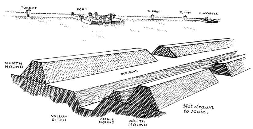
Let’s read on…… “The Wall was placed slightly north of the existing line of military installations between the River Tyne and the Solway Firth. Its line was carefully chosen to make best use of the topography, and it was surveyed from each end towards the middle, or rather towards the crags, in sections. Building in the east started at the point where the road from the south, Dere Street, met the Wall and where later a gate, the Portgate, was erected.”
As first planned, most of the Wall was to be built in stone, but the eastern 30-mile section was in turf. In front of both was a substantial ditch, except where crags or rivers made this unnecessary. At each mile a gate was protected by a small guard post called a milecastle.
Between each pair of milecastles lay two towers (turrets), creating a pattern of observation points every third of a mile. The stone wall, with a maximum height of about 15 feet (4.6 metres), was 10 Roman feet (3 metres) wide, wide enough for there to have been a walkway along the top, and perhaps also a parapet wall. The turf sector was 20 Roman feet (6 metres) wide.
To the north of the turf sector lay three advance forts, all probably part of this plan, but otherwise the forts remained on the Stanegate behind the Wall.
Before the first plan was completed, a radical change led to the placing of forts on the wall line and down the Cumbrian coast, and the construction of an earthwork to the south.
The forts, each apparently built for a single unit and at a basic spacing of 7⅓ miles, were placed astride the Wall wherever possible. This allowed three main gates, each with two entrances, making the equivalent of six milecastle gates, to provide access to the north; the double-portal south gate was supplemented by two small side gates. The position of the forts and the provision of so many gates suggest that a requirement for increased mobility led to this change.
The addition of the forts was followed by the construction of an earthwork to the south 120 Roman feet (an actus – about 35 metres) wide. This consisted of a central ditch between two mounds. Causeways, surmounted by gates, were provided at forts. The purpose of the Vallum, as this earthwork is known, was presumably to protect the rear of the frontier zone.
So, the Vallum is a defensive ditch, then?
Sounds quite simple doesn’t it……. Until you start looking at the detail!!
I have been studying the 1497+ (for every two scheduled Dyke I have measured and categorised I have found on average one not scheduled or noticed) Dykes in Britain (including Southern Ireland) and noticed a few cut through the Vallum, which is strange as I have observed that the Vallum either starts or ends on these occasions.
Consequently, I have started to measure and track the Vallum via LiDAR maps I have at my deposal and have found severe flaws in the English Heritage Literature. So let’s look at just one section of Hadrian’s Wall to show you examples of how the present understanding of Hadrian’s Wall does not hold up to scrutiny.
Scheduled Monument section 1010987
– The Vallum between the field boundary south east of Heads Wood and the A6021 road in Wall Mile 57.
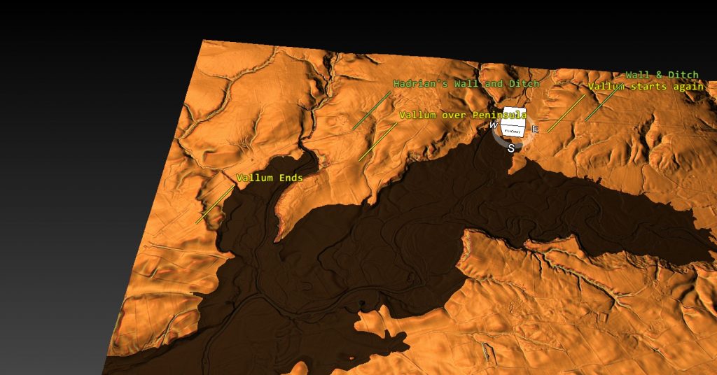
The first problem we find is that it disappears for 3,000 metres without reason – not a very effective ‘defensive structure’ with gaps of this size – and our survey has identified quite a few gaps like this throughout the line of the Wall.
The second problem is its construction – it’s far too big? The LiDAR maps clearly show its 36m wide consisting of TWO banks(one on each site) of 13m wide and a Ditch of 10m with a flat bottom (found on previous excavations) – if it’s defensive, it’s rubbish?? A defensive ditch has ONE bank (which you place a wooden palisade) and a V-shaped smaller ditch 3 – 4m, so soldiers fall in and break their legs – these ditches you can jump in and march across??
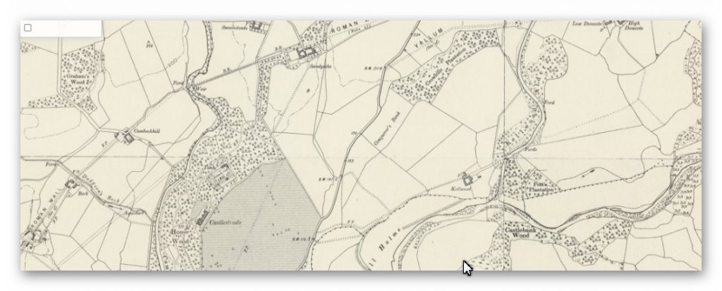
The third conundrum is that the Wall is sometimes a fair distance from the Vallum. The construction seems to hug the lowlands near or on rivers and shorelines – sometimes connecting with prehistoric Dykes, as we have previously suggested.
The evidence suggests that the Vallum was a Dyke, which would make more sense as the Wall needed constant supplies, and to date, nobody has worked out how on earth you move TWO MILLION CUBIC METRES OF STONE without using boats?
Moreover, the identification of the double-banked Dyke shows that the Roman’s had ‘tow paths’ on both sides of the Dyke for ease of two-way traffic (unlike the Victorian canal system) and that the later ‘Military Way’ Road was simply the continuation of this ‘goods connection’ by using one of the banks when the Dyke dried or silted at a later date.
What our research has shown is that there was a great possibility (due to location) that a prehistoric Dyke (like Wansdyke and offa) was already in this area, and the Roman’s used it for convenience and to save money (labour) on their wall endeavour.
I have publishing a book on the Vallum and Hadrian’s Wall as the Antonine Wall has similar characteristics to the Vallum, and with LiDAR, we can again correct (like my first trilogy) the so-called ‘known history’ of Britain.(The Problem with Hadrian’s Vallum)
Podcast

Author’s Biography
Robert John Langdon, a polymathic luminary, emerges as a writer, historian, and eminent specialist in LiDAR Landscape Archaeology.
His intellectual voyage has interwoven with stints as an astute scrutineer for governmental realms and grand corporate bastions, a tapestry spanning British Telecommunications, Cable and Wireless, British Gas, and the esteemed University of London.
A decade hence, Robert’s transition into retirement unfurled a chapter of insatiable curiosity. This phase saw him immerse himself in Politics, Archaeology, Philosophy, and the enigmatic realm of Quantum Mechanics. His academic odyssey traversed the venerable corridors of knowledge hubs such as the Museum of London, University College London, Birkbeck College, The City Literature Institute, and Chichester University.
In the symphony of his life, Robert is a custodian of three progeny and a pair of cherished grandchildren. His sanctuary lies ensconced in the embrace of West Wales, where he inhabits an isolated cottage, its windows framing a vista of the boundless sea – a retreat from the scrutinous gaze of the Her Majesty’s Revenue and Customs, an amiable clandestinity in the lap of nature’s embrace.
Exploring Prehistoric Britain: A Journey Through Time
My blog delves into the fascinating mysteries of prehistoric Britain, challenging conventional narratives and offering fresh perspectives based on cutting-edge research, particularly using LiDAR technology. I invite you to explore some key areas of my research. For example, the Wansdyke, often cited as a defensive structure, is re-examined in light of new evidence. I’ve presented my findings in my blog post Wansdyke: A British Frontier Wall – ‘Debunked’, and a Wansdyke LiDAR Flyover video further visualizes my conclusions.
My work also often challenges established archaeological dogma. I argue that many sites, such as Hambledon Hill, commonly identified as Iron Age hillforts are not what they seem. My posts Lidar Investigation Hambledon Hill – NOT an ‘Iron Age Fort’ and Unmasking the “Iron Age Hillfort” Myth explore these ideas in detail and offer an alternative view. Similarly, sites like Cissbury Ring and White Sheet Camp, also receive a re-evaluation based on LiDAR analysis in my posts Lidar Investigation Cissbury Ring through time and Lidar Investigation White Sheet Camp, revealing fascinating insights into their true purpose. I have also examined South Cadbury Castle, often linked to the mythical Camelot56.
My research also extends to the topic of ancient water management, including the role of canals and other linear earthworks. I have discussed the true origins of Car Dyke in multiple posts including Car Dyke – ABC News PodCast and Lidar Investigation Car Dyke – North Section, suggesting a Mesolithic origin2357. I also explore the misidentification of Roman aqueducts, as seen in my posts on the Great Chesters (Roman) Aqueduct. My research has also been greatly informed by my post-glacial flooding hypothesis which has helped to inform the landscape transformations over time. I have discussed this hypothesis in several posts including AI now supports my Post-Glacial Flooding Hypothesis and Exploring Britain’s Flooded Past: A Personal Journey
Finally, my blog also investigates prehistoric burial practices, as seen in Prehistoric Burial Practices of Britain and explores the mystery of Pillow Mounds, often mistaken for medieval rabbit warrens, but with a potential link to Bronze Age cremation in my posts: Pillow Mounds: A Bronze Age Legacy of Cremation? and The Mystery of Pillow Mounds: Are They Really Medieval Rabbit Warrens?. My research also includes the astronomical insights of ancient sites, for example, in Rediscovering the Winter Solstice: The Original Winter Festival. I also review new information about the construction of Stonehenge in The Stonehenge Enigma.
Further Reading
For those interested in British Prehistory, visit www.prehistoric-britain.co.uk, a comprehensive resource featuring an extensive collection of archaeology articles, modern LiDAR investigations, and groundbreaking research. The site also includes insights and extracts from the acclaimed Robert John Langdon Trilogy, a series of books exploring Britain during the Prehistoric period. Titles in the trilogy include The Stonehenge Enigma, Dawn of the Lost Civilisation, and The Post Glacial Flooding Hypothesis, offering compelling evidence about ancient landscapes shaped by post-glacial flooding.
To further explore these topics, Robert John Langdon has developed a dedicated YouTube channel featuring over 100 video documentaries and investigations that complement the trilogy. Notable discoveries and studies showcased on the channel include 13 Things that Don’t Make Sense in History and the revelation of Silbury Avenue – The Lost Stone Avenue, a rediscovered prehistoric feature at Avebury, Wiltshire.
In addition to his main works, Langdon has released a series of shorter, accessible publications, ideal for readers delving into specific topics. These include:
- The Ancient Mariners
- Stonehenge Built 8300 BCE
- Old Sarum
- Prehistoric Rivers
- Dykes, Ditches, and Earthworks
- Echoes of Atlantis
- Homo Superior
- 13 Things that Don’t Make Sense in History
- Silbury Avenue – The Lost Stone Avenue
- Offa’s Dyke
- The Stonehenge Enigma
- The Post-Glacial Flooding Hypothesis
- The Stonehenge Hoax
- Dawn of the Lost Civilisation
- Darwin’s Children
- Great Chester’s Roman Aqueduct
- Wansdyke
For active discussions and updates on the trilogy’s findings and recent LiDAR investigations, join our vibrant community on Facebook. Engage with like-minded enthusiasts by leaving a message or contributing to debates in our Facebook Group.
Whether through the books, the website, or interactive videos, we aim to provide a deeper understanding of Britain’s fascinating prehistoric past. We encourage you to explore these resources and uncover the mysteries of ancient landscapes through the lens of modern archaeology.
For more information, including chapter extracts and related publications, visit the Robert John Langdon Author Page. Dive into works such as The Stonehenge Enigma or Dawn of the Lost Civilisation, and explore cutting-edge theories that challenge traditional historical narratives.
Other Blogs
1
a
- AI now Supports – Homo Superior
- AI now supports my Post-Glacial Flooding Hypothesis
- Alexander the Great sailed into India – where no rivers exist today
- Ancient Prehistoric Canals – The Vallum
- Ancient Secrets of Althorp – debunked
- Antler Picks built Ancient Monuments – yet there is no real evidence
- Antonine Wall – Prehistoric Canals (Dykes)
- Archaeological ‘pulp fiction’ – has archaeology turned from science?
- Archaeological Pseudoscience
- Archaeology in the Post-Truth Era
- Archaeology: A Bad Science?
- Archaeology: A Harbour for Fantasists?
- Archaeology: Fact or Fiction?
- Archaeology: The Flaws of Peer Review
- Archaeology’s Bayesian Mistake: Stop Averaging the Past
- Are Raised Beaches Archaeological Pseudoscience?
- Atlantis Found: The Mathematical Proof That Plato’s Lost City Was Doggerland
- ATLANTIS: Discovery with Dan Snow Debunked
- Avebury Ditch – Avebury Phase 2
- Avebury Post-Glacial Flooding
- Avebury through time
- Avebury’s great mystery revealed
- Avebury’s Lost Stone Avenue – Flipbook
b
- Battlesbury Hill – Wiltshire
- Beyond Stone and Bone: Rethinking the Megalithic Architects of Northern Europe
- BGS Prehistoric River Map
- Blackhenge: Debunking the Media misinterpretation of the Stonehenge Builders
- Brain capacity (Cro-Magnon Man)
- Brain capacity (Cro-Magnon Man)
- Britain’s First Road – Stonehenge Avenue
- Britain’s Giant Prehistoric Waterways
- British Roman Ports miles away from the coast
c
- Caerfai Promontory Fort – Archaeological Nonsense
- Car Dyke – ABC News PodCast
- Car Dyke – North Section
- CASE STUDY – An Inconvenient TRUTH (Craig Rhos Y Felin)
- Case Study – River Avon
- Case Study – Woodhenge Reconstruction
- Chapter 2 – Craig Rhos-Y-Felin Debunked
- Chapter 2 – Stonehenge Phase I
- Chapter 2 – Variation of the Species
- Chapter 3 – Post Glacial Sea Levels
- Chapter 3 – Stonehenge Phase II
- Chapter 7 – Britain’s Post-Glacial Flooding
- Cissbury Ring through time
- Cro-Magnon Megalithic Builders: Measurement, Biology, and the DNA
- Cro-Magnons – An Explainer
d
- Darwin’s Children – Flipbook
- Darwin’s Children – The Cro-Magnons
- Dawn of the Lost Civilisation – Flipbook
- Dawn of the Lost Civilisation – Introduction
- Digging for Britain – Cerne Abbas 1 of 2
- Digging for Britain Debunked – Cerne Abbas 2
- Digging Up Britain’s Past – Debunked
- DLC Chapter 1 – The Ascent of Man
- Durrington Walls – Woodhenge through time
- Durrington Walls Revisited: Platforms, Fish Traps, and a Managed Mesolithic Landscape
- Dyke Construction – Hydrology 101
- Dykes Ditches and Earthworks
- DYKES of Britain
e
f
g
h
- Hadrian’s Wall – Military Way Hoax
- Hadrian’s Wall – the Stanegate Hoax
- Hadrian’s Wall LiDAR investigation
- Hambledon Hill – NOT an ‘Iron Age Fort’
- Hayling Island Lidar Maps
- Hidden Sources of Ancient Dykes: Tracing Underground Groundwater Fractals
- Historic River Avon
- Hollingsbury Camp Brighton
- Hollows, Sunken Lanes and Palaeochannels
- Homo Superior – Flipbook
- Homo Superior – History’s Giants
- How Lidar will change Archaeology
i
l
m
- Maiden Castle through time
- Mathematics Meets Archaeology: Discovering the Mesolithic Origins of Car Dyke
- Mesolithic River Avon
- Mesolithic Stonehenge
- Minerals found in Prehistoric and Roman Quarries
- Mining in the Prehistoric to Roman Period
- Mount Caburn through time
- Mysteries of the Oldest Boatyard Uncovered
- Mythological Dragons – a non-existent animal that is shared by the World.
o
- Offa’s Dyke Flipbook
- Old Sarum Lidar Map
- Old Sarum Through Time…………….
- On Sunken Lands of the North Sea – Lived the World’s Greatest Civilisation.
- OSL Chronicles: Questioning Time in the Geological Tale of the Avon Valley
- Oswestry LiDAR Survey
- Oswestry through time
- Oysters in Archaeology: Nature’s Ancient Water Filters?
p
- Pillow Mounds: A Bronze Age Legacy of Cremation?
- Post Glacial Flooding – Flipbook
- Prehistoric Burial Practices of Britain
- Prehistoric Canals – Wansdyke
- Prehistoric Canals – Wansdyke
- Prehistoric Canals (Dykes) – Great Chesters Aqueduct (The Vallum Pt. 4)
- Prehistoric Canals (Dykes) – Hadrian’s Wall Vallum (pt 1)
- Prehistoric Canals (Dykes) – Offa’s Dyke (Chepstow)
- Prehistoric Canals (Dykes) – Offa’s Dyke (LiDAR Survey)
- Prehistoric Canals (Dykes) – Offa’s Dyke Survey (End of Section A)
- Prehistoric Canals (Dykes) – Wansdyke (4)
- Prehistoric Canals Wansdyke 2
- Professor Bonkers and the mad, mad World of Archaeology
r
- Rebirth in Stone: Decrypting the Winter Solstice Legacy of Stonehenge
- Rediscovering the Winter Solstice: The Original Winter Festival
- Rethinking Ancient Boundaries: The Vallum and Offa’s Dyke”
- Rethinking Ogham: Could Ireland’s Oldest Script Have Begun as a Tally System?
- Rethinking The Past: Mathematical Proof of Langdon’s Post-Glacial Flooding Hypothesis
- Revolutionising History: Car Dyke Unveiled as Prehistoric & the Launch of FusionBook 360
- Rising Evidence, Falling Rivers: The Real Story of Europe’s First Farmers
- Rivers of the Past Were Higher: A Fresh Perspective on Prehistoric Hydrology
s
- Sea Level Changes
- Section A – NY26SW
- Section B – NY25NE & NY26SE
- Section C – NY35NW
- Section D – NY35NE
- Section E – NY46SW & NY45NW
- Section F – NY46SE & NY45NE
- Section G – NY56SW
- Section H – NY56NE & NY56SE
- Section I – NY66NW
- Section J – NY66NE
- Section K – NY76NW
- Section L – NY76NE
- Section M – NY87SW & NY86NW
- Section N – NY87SE
- Section O – NY97SW & NY96NW
- Section P – NY96NE
- Section Q – NZ06NW
- Section R – NZ06NE
- Section S – NZ16NW
- Section T – NZ16NE
- Section U – NZ26NW & NZ26SW
- Section V – NZ26NE & NZ26SE
- Silbury Avenue – Avebury’s First Stone Avenue
- Silbury Hill
- Silbury Hill / Sanctuary – Avebury Phase 3
- Somerset Plain – Signs of Post-Glacial Flooding
- South Cadbury Castle – Camelot
- Statonbury Camp near Bath – an example of West Wansdyke
- Stone me – the druids are looking the wrong way on Solstice day
- Stone Money – Credit System
- Stone Transportation and Dumb Censorship
- Stonehenge – Monument to the Dead
- Stonehenge Hoax – Dating the Monument
- Stonehenge Hoax – Round Monument?
- Stonehenge Hoax – Summer Solstice
- Stonehenge LiDAR tour
- Stonehenge Phase 1 — Britain’s First Monument
- Stonehenge Phase I (The Stonehenge Landscape)
- Stonehenge Solved – Pythagorean maths put to use 4,000 years before he was born
- Stonehenge Stone Transportation
- Stonehenge Through Time
- Stonehenge, Doggerland and Atlantis connection
- Stonehenge: Discovery with Dan Snow Debunked
- Stonehenge: The Worlds First Computer
- Stonehenge’s The Lost Circle Revealed – DEBUNKED
t
- Ten Reasons Why Car Dyke Blows Britain’s Earthwork Myths Out of the Water
- Ten Things You Didn’t Know About Britain’s Prehistoric Flooded Past
- Ten thousand year old boats found on Northern Europe’s Hillsides
- Ten thousand-year-old boats found on Northern Europe’s Hillsides
- The “Hunter-Gatherer” Myth: Why It’s Time to Bury This Outdated Term
- The Ancient Mariners – Flipbook
- The Ancient Mariners – Prehistoric seafarers of the Mesolithic
- The Beringian Migration Myth: Why the Peopling of the Americas by Foot is Mathematically and Logistically Impossible
- The Bluestone Enigma
- The Cro-Magnon Cover-Up: How DNA and PR Labels Erased Our Real Ancestry
- The Dolmen and Long Barrow Connection
- The Durrington Walls Hoax – it’s not a henge?
- The Dyke Myth Collapses: Excavation and Dating Prove Britain’s Great Dykes Are Prehistoric Canals
- The First European Smelted Bronzes
- The Fury of the Past: Natural Disasters in Historical and Prehistoric Britain
- The Giant’s Graves of Cumbria
- The Giants of Prehistory: Cro-Magnon and the Ancient Monuments
- The Great Antler Pick Hoax
- The Great Chichester Hoax – A Bridge too far?
- The Great Dorchester Aqueduct Hoax
- The Great Farming Hoax – (Einkorn Wheat)
- The Great Farming Migration Hoax
- The Great Hadrian’s Wall Hoax
- The Great Iron Age Hill Fort Hoax
- The Great Offa’s Dyke Hoax
- The Great Prehistoric Migration Hoax
- The Great Stone Transportation Hoax
- The Great Stonehenge Hoax
- The Great Wansdyke Hoax
- The Henge and River Relationship
- The Logistical Impossibility of Defending Maiden Castle
- The Long Barrow and Dolman Enigma
- The Long Barrow Mystery
- The Long Barrow Mystery: Unravelling Ancient Connections
- The Lost Island of Avalon – revealed
- The Maiden Way Hoax – A Closer Look at an Ancient Road’s Hidden History
- The Maths – LGM total ice volume
- The Mystery of Pillow Mounds: Are They Really Medieval Rabbit Warrens?
- The Old Sarum Hoax
- The Oldest Boat Yard in the World found in Wales
- The Perils of Paradigm Shifts: Why Unconventional Hypotheses Get Branded as Pseudoscience
- The Post-Glacial Flooding Hypothesis – Flipbook
- The Post-Glacial Flooding Theory
- The Problem with Hadrian’s Vallum
- The Rise of the Cro-Magnon (Homo Superior)
- The Roman Military Way Hoax
- The Silbury Hill Lighthouse?
- The Stonehenge Avenue
- The Stonehenge Avenue
- The Stonehenge Code: Unveiling its 10,000-Year-Old Secret
- The Stonehenge Enigma – Flipbook
- The Stonehenge Enigma: What Lies Beneath? – Debunked
- The Stonehenge Hoax – Bluestone Quarry Site
- The Stonehenge Hoax – Flipbook
- The Stonehenge Hoax – Moving the Bluestones
- The Stonehenge Hoax – Periglacial Stripes
- The Stonehenge Hoax – Station Stones
- The Stonehenge Hoax – Stonehenge’s Location
- The Stonehenge Hoax – The Ditch
- The Stonehenge Hoax – The Slaughter Stone
- The Stonehenge Hoax – The Stonehenge Layer
- The Stonehenge Hoax – Totem Poles
- The Stonehenge Hoax – Woodhenge
- The Stonehenge Hospital
- The Subtropical Britain Hoax
- The Troy, Hyperborea and Atlantis Connection
- The Vallum @ Hadrian’s Wall – it’s Prehistoric!
- The Vallum at Hadrian’s Wall (Summary)
- The Woodhenge Hoax
- Three Dykes – Kidland Forest
- Top Ten misidentified Fire Beacons in British History
- Troy Debunked
- TSE – DVD Barrows
- TSE DVD – An Inconvenient Truth
- TSE DVD – Antler Picks
- TSE DVD – Avebury
- TSE DVD – Durrington Walls & Woodhenge
- TSE DVD – Dykes
- TSE DVD – Epilogue
- TSE DVD – Stonehenge Phase I
- TSE DVD – Stonehenge Phase II
- TSE DVD – The Post-Glacial Hypothesis
- TSE DVD Introduction
- TSE DVD Old Sarum
- Twigs, Charcoal, and the Death of the Saxon Dyke Myth
w
- Wansdyke – Short Film
- Wansdyke East – Prehistoric Canals
- Wansdyke Flipbook
- Wansdyke LiDAR Flyover
- Wansdyke: A British Frontier Wall – ‘Debunked’
- Was Columbus the first European to reach America?
- What Archaeology Missed Beneath Stonehenge
- White Sheet Camp
- Why a Simple Fence Beats a Massive Dyke (and What That Means for History)
- Windmill Hill – Avebury Phase 1
- Winter Solstice – Science, Propaganda and Indoctrination
- Woodhenge – the World’s First Lighthouse?



Pingback: Hadrian’s Wall LiDAR investigation - Prehistoric Britain
Pingback: Section A – NY26SW - Prehistoric Britain
Pingback: Section B – NY25NE & NY26SE - Prehistoric Britain
Pingback: Section C – NY35NW - Prehistoric Britain
Pingback: Section D – NY35NE - Prehistoric Britain
Pingback: Section E – NY46SW & NY45NW - Prehistoric Britain
Pingback: Section F – NY46SE & NY45NE - Prehistoric Britain
Pingback: Section G - NY56SW - Prehistoric Britain
Pingback: Section H - NY56NE & NY56SE - Prehistoric Britain
Pingback: Section I - NY66NW - Prehistoric Britain
Pingback: Section J - NY66NE - Prehistoric Britain
Pingback: Section K - NY76NW - Prehistoric Britain
Pingback: Section L - NY76NE - Prehistoric Britain
Pingback: Section M - NY87SW & NY86NW - Prehistoric Britain
Pingback: Section N - NY87SE - Prehistoric Britain