Digging for Britain Debunked – Cerne Abbas 2
Contents
Introduction
In the first part of our exploration, we delved into the televised program ‘Digging for Britain’ and scrutinised the methodology employed by the purported experts, questioning the reliability of their conclusions regarding the dating of Cerne Abbas. Our investigation highlighted flaws in the sampling process, particularly the oversight of soil creep, which significantly impacts the interpretation of the site’s history. (Digging for Britain Debunked)
Now, in this second part, our focus shifts to the professionalism of archaeologists involved in such endeavours and, by extension, the broader state of the archaeological profession in the 21st century. A critical lens is turned towards the National Trust’s excavation efforts, particularly the four trenches dedicated to OSL dating. Despite the extensive timeframe of over two years for this undertaking, a conspicuous absence of an official report raises concerns about transparency and the ability for scrutiny by other knowledgeable individuals. This delay in producing and sharing findings with the wider community questions the efficiency and accessibility of archaeological information.
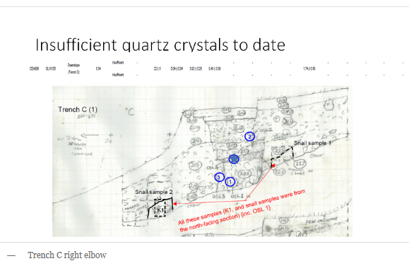
The quality of documentation further comes into question, as hand-drawn cross-sections, seemingly rushed and lacking the meticulous detail expected in rigorous scientific practices, were presented. This not only reveals an apparent ‘back of an envelope’ approach but also underscores a profound oversight by the experts. Despite having two years for scrutiny and examination, critical questions were left unexplored, a shortcoming magnified by the collaboration with the BBC for the televised program.
Cerne Abbas
The absence of a comprehensive and timely report, coupled with the apparent lack of attention to detail in documentation, casts doubt on the thoroughness and professionalism of the archaeological efforts surrounding Cerne Abbas. The urgency to present findings to the media and create a documentary may have compromised the meticulousness required in archaeological endeavours.
This prompts a broader reflection on the state of the archaeological profession itself. The slow pace of report publication, potential gaps in expertise, and a seeming reluctance to subject findings to robust scrutiny raise concerns about the agility and accountability of the discipline in contemporary times.
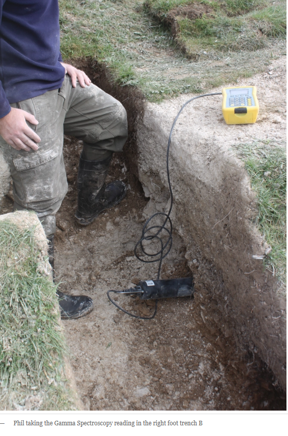
The deficiencies in the excavation process around Cerne Abbas become more apparent when we scrutinise the placement of the trenches and the sampling locations. The hand-drawn illustrations (which I consider ‘outdated’ in an era of affordable and prevalent 3D high-definition cameras) indicate that samples were taken from the topsoil just above the chalk bedrock. However, a photograph reveals a more accurate location at the bottom of the topsoil near the bedrock chalk, leading to the Saxon date conclusion.
Poor Conclusions
A critical oversight emerges when we consider the implications of the Saxon date. If accurate, the absence of topsoil dating back thousands of years raises intriguing questions. Three plausible scenarios are explored: deliberate removal of soil before Cerne Abbas construction, the absence of soil initially, or inaccuracies in OSL dating.
Option one, soil removal, implies an intention to obliterate what was originally present, raising logistical questions about the necessity for such an extensive process compared to the simplicity of laying new lines on existing chalk.
Option two speculates on the absence of soil due to something atop the bedrock, a theory we will delve into further.
Option three questions the accuracy of OSL dates, which, if proven, could cast doubt on the entire OSL science.
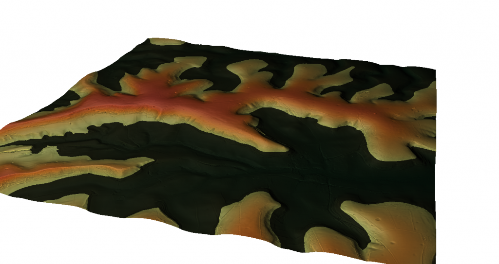
Option two gains credence when exploring the Post-Glacial Hypothesis, grounded in the notion of elevated water levels in prehistoric times. LiDAR imagery of the site reveals a landscape shaped by Mesolithic waters, with identified natural harbours and Neolithic camps indicating the higher historical river levels. Archaeological findings, including tools and earthworks, support the hypothesis of the river running parallel to the figure being significantly higher during the Neolithic period.
Prehistoric Landscape
This scenario accounts for approximately seven thousand years with no topsoil on the figure. Examining the bedrock reveals signs of extensive water weathering, consistent with chalk erosion over thousands of years. The excavation report and photographs uncover broken chalk at the bottom of the topsoil, demonstrating water-induced erosion and redeposition. The darkened appearance, a result of drying after being broken and re-laid on top, mirrors the common impact of water on solid chalk.
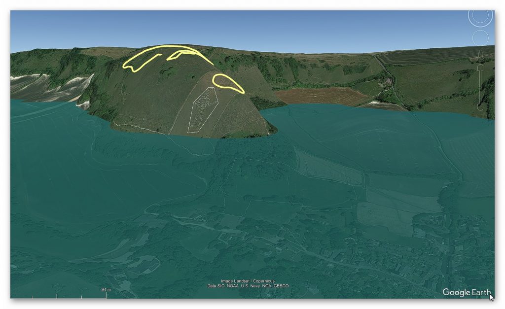
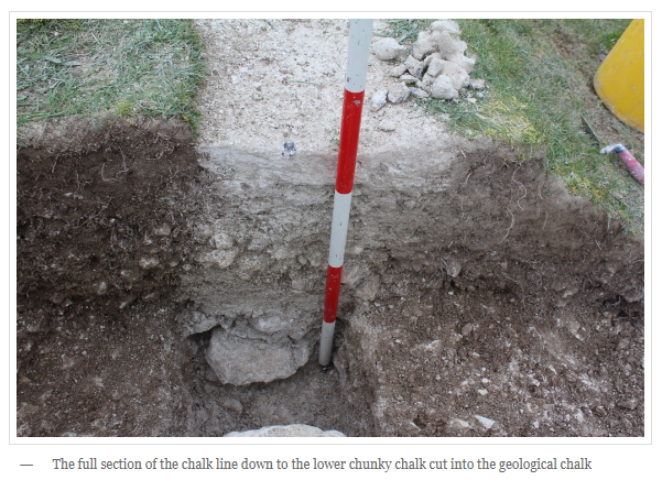
Further evidence points to Post-Glacial Flooding and a Neolithic origin for the figure, strategically marking the entrance to the harbour. LiDAR maps hint at a man with a balance on his shoulders or head, potentially representing a trading centre surrounded by quarries and mining pits.
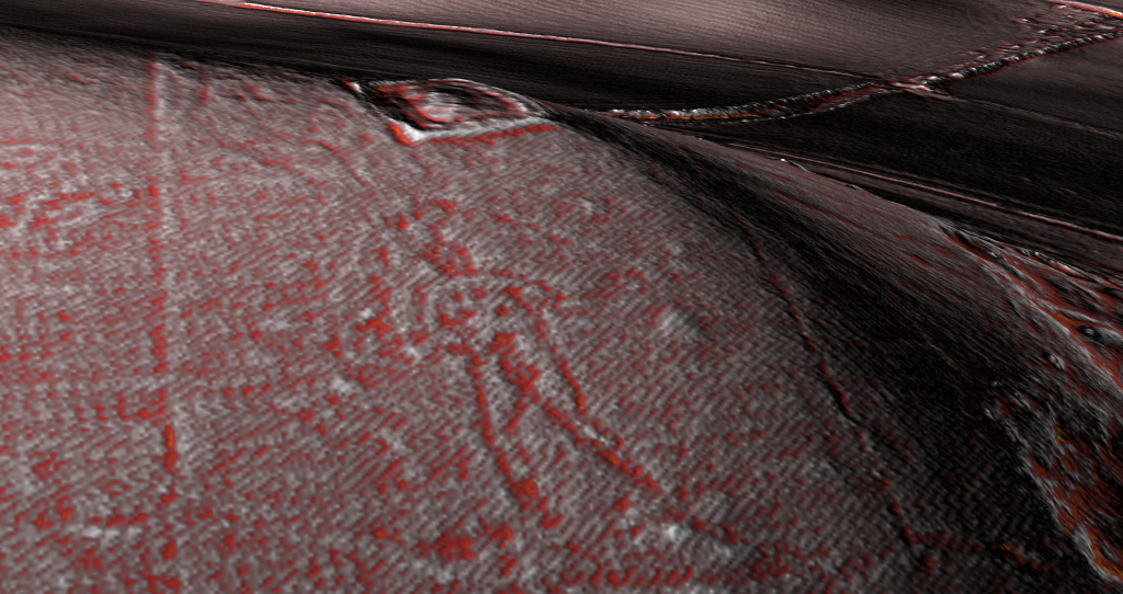

The intricacies of Cerne Abbas, when viewed through the lens of geological processes and archaeological evidence, unfold a narrative of ancient landscapes shaped by water, a figure emerging from millennia of erosion, and a Neolithic trading hub leaving its mark on the chalky canvas of history.
Long Man of Wilmington
NB. The findings at the The Long Man of Wilmington by Prof. Martin Bell shows very similar findings and geology as Cerne Abbas –
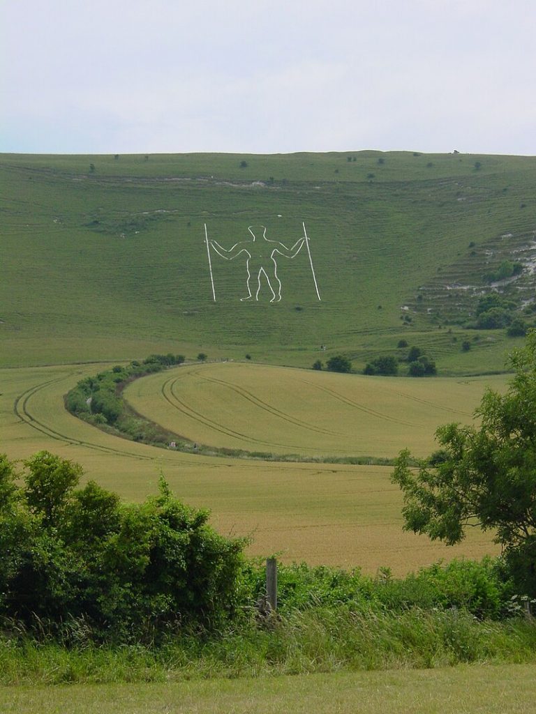
“Our method was to machine cut a trench at the base of the slope to look at the sediment sequence, then carefully hand excavate an adjoining strip, recording in three dimensions the positions of all artefacts, no matter how modern, in order to date each layer.
At the base of our trench there were chalk meltwater muds from a time of rapid physical weathering at the end of the last Ice Age. Above these were bowl-shaped features, perhaps tree-throw pits because they contained land snails of woodland habitats, showing this part of the slope had been wooded earlier in the Postglacial. They also contained some flint flakes, so they could be archaeological features.
Over these was a buried soil. Ed Rhodes, formerly of the Research Laboratory for Archaeology at Oxford, now of the Australian National University, has used OSL to date this soil to the mid-2nd millennium BC. The snails show that by this time the landscape was open. Later in the Bronze Age the soil was buried by more soil derived from cultivation at the base of the slope. Snails show the escarpment above was grassland. Many sites on the South Downs show evidence for quite extensive Bronze Age soil erosion. Bronze Age and Neolithic pottery and flints from the basal soil and the colluvium indicate that a settlement was nearby.”
They called the broken chalk we saw in these excavations ‘chalk meltwater muds’ and he is correct but this kind of deposit can only be produced by thousands of years of water erosion not a couple of hundred and his OSL dates confirm this – as just above this level is a OSL date of 2,000 BCE. We have 8,000 years of top soil missing as the site like Carne Abbass as it was covered with river water creating another natural harbour – and would you believe it – it also has a Neolthic Settlement (trading post above it on the top of the hill) indicating these figures were once used as boat markers/sign posts on the raised rivers of the past, before being change in the saxon period and beyond.
Further Reading
For information about British Prehistory, visit www.prehistoric-britain.co.uk for the most extensive archaeology blogs and investigations collection, including modern LiDAR reports. This site also includes extracts and articles from the Robert John Langdon Trilogy about Britain in the Prehistoric period, including titles such as The Stonehenge Enigma, Dawn of the Lost Civilisation and the ultimate proof of Post Glacial Flooding and the landscape we see today.
Robert John Langdon has also created a YouTube web channel with over 100 investigations and video documentaries to support his classic trilogy (Prehistoric Britain). He has also released a collection of strange coincidences that he calls ‘13 Things that Don’t Make Sense in History’ and his recent discovery of a lost Stone Avenue at Avebury in Wiltshire called ‘Silbury Avenue – the Lost Stone Avenue’.
Langdon has also produced a series of ‘shorts’, which are extracts from his main body of books:
For active discussions on the findings of the TRILOGY and recent LiDAR investigations that are published on our WEBSITE, you can join our and leave a message or join the debate on our Facebook Group.
Other Blogs
1
a
- AI now Supports – Homo Superior
- AI now supports my Post-Glacial Flooding Hypothesis
- Alexander the Great sailed into India – where no rivers exist today
- Ancient Prehistoric Canals – The Vallum
- Ancient Secrets of Althorp – debunked
- Antler Picks built Ancient Monuments – yet there is no real evidence
- Antonine Wall – Prehistoric Canals (Dykes)
- Archaeological ‘pulp fiction’ – has archaeology turned from science?
- Archaeological Pseudoscience
- Archaeology in the Post-Truth Era
- Archaeology: A Bad Science?
- Archaeology: A Harbour for Fantasists?
- Archaeology: Fact or Fiction?
- Archaeology: The Flaws of Peer Review
- Archaeology’s Bayesian Mistake: Stop Averaging the Past
- Are Raised Beaches Archaeological Pseudoscience?
- Atlantis Found: The Mathematical Proof That Plato’s Lost City Was Doggerland
- ATLANTIS: Discovery with Dan Snow Debunked
- Avebury Ditch – Avebury Phase 2
- Avebury Post-Glacial Flooding
- Avebury through time
- Avebury’s great mystery revealed
- Avebury’s Lost Stone Avenue – Flipbook
b
- Battlesbury Hill – Wiltshire
- Beyond Stone and Bone: Rethinking the Megalithic Architects of Northern Europe
- BGS Prehistoric River Map
- Blackhenge: Debunking the Media misinterpretation of the Stonehenge Builders
- Brain capacity (Cro-Magnon Man)
- Brain capacity (Cro-Magnon Man)
- Britain’s First Road – Stonehenge Avenue
- Britain’s Giant Prehistoric Waterways
- British Roman Ports miles away from the coast
c
- Caerfai Promontory Fort – Archaeological Nonsense
- Car Dyke – ABC News PodCast
- Car Dyke – North Section
- CASE STUDY – An Inconvenient TRUTH (Craig Rhos Y Felin)
- Case Study – River Avon
- Case Study – Woodhenge Reconstruction
- Chapter 2 – Craig Rhos-Y-Felin Debunked
- Chapter 2 – Stonehenge Phase I
- Chapter 2 – Variation of the Species
- Chapter 3 – Post Glacial Sea Levels
- Chapter 3 – Stonehenge Phase II
- Chapter 7 – Britain’s Post-Glacial Flooding
- Cissbury Ring through time
- Cro-Magnon Megalithic Builders: Measurement, Biology, and the DNA
- Cro-Magnons – An Explainer
d
- Darwin’s Children – Flipbook
- Darwin’s Children – The Cro-Magnons
- Dawn of the Lost Civilisation – Flipbook
- Dawn of the Lost Civilisation – Introduction
- Digging for Britain – Cerne Abbas 1 of 2
- Digging for Britain Debunked – Cerne Abbas 2
- Digging Up Britain’s Past – Debunked
- DLC Chapter 1 – The Ascent of Man
- Durrington Walls – Woodhenge through time
- Durrington Walls Revisited: Platforms, Fish Traps, and a Managed Mesolithic Landscape
- Dyke Construction – Hydrology 101
- Dykes Ditches and Earthworks
- DYKES of Britain
e
f
g
h
- Hadrian’s Wall – Military Way Hoax
- Hadrian’s Wall – the Stanegate Hoax
- Hadrian’s Wall LiDAR investigation
- Hambledon Hill – NOT an ‘Iron Age Fort’
- Hayling Island Lidar Maps
- Hidden Sources of Ancient Dykes: Tracing Underground Groundwater Fractals
- Historic River Avon
- Hollingsbury Camp Brighton
- Hollows, Sunken Lanes and Palaeochannels
- Homo Superior – Flipbook
- Homo Superior – History’s Giants
- How Lidar will change Archaeology
i
l
m
- Maiden Castle through time
- Mathematics Meets Archaeology: Discovering the Mesolithic Origins of Car Dyke
- Mesolithic River Avon
- Mesolithic Stonehenge
- Minerals found in Prehistoric and Roman Quarries
- Mining in the Prehistoric to Roman Period
- Mount Caburn through time
- Mysteries of the Oldest Boatyard Uncovered
- Mythological Dragons – a non-existent animal that is shared by the World.
o
- Offa’s Dyke Flipbook
- Old Sarum Lidar Map
- Old Sarum Through Time…………….
- On Sunken Lands of the North Sea – Lived the World’s Greatest Civilisation.
- OSL Chronicles: Questioning Time in the Geological Tale of the Avon Valley
- Oswestry LiDAR Survey
- Oswestry through time
- Oysters in Archaeology: Nature’s Ancient Water Filters?
p
- Pillow Mounds: A Bronze Age Legacy of Cremation?
- Post Glacial Flooding – Flipbook
- Prehistoric Burial Practices of Britain
- Prehistoric Canals – Wansdyke
- Prehistoric Canals – Wansdyke
- Prehistoric Canals (Dykes) – Great Chesters Aqueduct (The Vallum Pt. 4)
- Prehistoric Canals (Dykes) – Hadrian’s Wall Vallum (pt 1)
- Prehistoric Canals (Dykes) – Offa’s Dyke (Chepstow)
- Prehistoric Canals (Dykes) – Offa’s Dyke (LiDAR Survey)
- Prehistoric Canals (Dykes) – Offa’s Dyke Survey (End of Section A)
- Prehistoric Canals (Dykes) – Wansdyke (4)
- Prehistoric Canals Wansdyke 2
- Professor Bonkers and the mad, mad World of Archaeology
r
- Rebirth in Stone: Decrypting the Winter Solstice Legacy of Stonehenge
- Rediscovering the Winter Solstice: The Original Winter Festival
- Rethinking Ancient Boundaries: The Vallum and Offa’s Dyke”
- Rethinking Ogham: Could Ireland’s Oldest Script Have Begun as a Tally System?
- Rethinking The Past: Mathematical Proof of Langdon’s Post-Glacial Flooding Hypothesis
- Revolutionising History: Car Dyke Unveiled as Prehistoric & the Launch of FusionBook 360
- Rising Evidence, Falling Rivers: The Real Story of Europe’s First Farmers
- Rivers of the Past Were Higher: A Fresh Perspective on Prehistoric Hydrology
s
- Sea Level Changes
- Section A – NY26SW
- Section B – NY25NE & NY26SE
- Section C – NY35NW
- Section D – NY35NE
- Section E – NY46SW & NY45NW
- Section F – NY46SE & NY45NE
- Section G – NY56SW
- Section H – NY56NE & NY56SE
- Section I – NY66NW
- Section J – NY66NE
- Section K – NY76NW
- Section L – NY76NE
- Section M – NY87SW & NY86NW
- Section N – NY87SE
- Section O – NY97SW & NY96NW
- Section P – NY96NE
- Section Q – NZ06NW
- Section R – NZ06NE
- Section S – NZ16NW
- Section T – NZ16NE
- Section U – NZ26NW & NZ26SW
- Section V – NZ26NE & NZ26SE
- Silbury Avenue – Avebury’s First Stone Avenue
- Silbury Hill
- Silbury Hill / Sanctuary – Avebury Phase 3
- Somerset Plain – Signs of Post-Glacial Flooding
- South Cadbury Castle – Camelot
- Statonbury Camp near Bath – an example of West Wansdyke
- Stone me – the druids are looking the wrong way on Solstice day
- Stone Money – Credit System
- Stone Transportation and Dumb Censorship
- Stonehenge – Monument to the Dead
- Stonehenge Hoax – Dating the Monument
- Stonehenge Hoax – Round Monument?
- Stonehenge Hoax – Summer Solstice
- Stonehenge LiDAR tour
- Stonehenge Phase 1 — Britain’s First Monument
- Stonehenge Phase I (The Stonehenge Landscape)
- Stonehenge Solved – Pythagorean maths put to use 4,000 years before he was born
- Stonehenge Stone Transportation
- Stonehenge Through Time
- Stonehenge, Doggerland and Atlantis connection
- Stonehenge: Discovery with Dan Snow Debunked
- Stonehenge: The Worlds First Computer
- Stonehenge’s The Lost Circle Revealed – DEBUNKED
t
- Ten Reasons Why Car Dyke Blows Britain’s Earthwork Myths Out of the Water
- Ten Things You Didn’t Know About Britain’s Prehistoric Flooded Past
- Ten thousand year old boats found on Northern Europe’s Hillsides
- Ten thousand-year-old boats found on Northern Europe’s Hillsides
- The “Hunter-Gatherer” Myth: Why It’s Time to Bury This Outdated Term
- The Ancient Mariners – Flipbook
- The Ancient Mariners – Prehistoric seafarers of the Mesolithic
- The Beringian Migration Myth: Why the Peopling of the Americas by Foot is Mathematically and Logistically Impossible
- The Bluestone Enigma
- The Cro-Magnon Cover-Up: How DNA and PR Labels Erased Our Real Ancestry
- The Dolmen and Long Barrow Connection
- The Durrington Walls Hoax – it’s not a henge?
- The Dyke Myth Collapses: Excavation and Dating Prove Britain’s Great Dykes Are Prehistoric Canals
- The First European Smelted Bronzes
- The Fury of the Past: Natural Disasters in Historical and Prehistoric Britain
- The Giant’s Graves of Cumbria
- The Giants of Prehistory: Cro-Magnon and the Ancient Monuments
- The Great Antler Pick Hoax
- The Great Chichester Hoax – A Bridge too far?
- The Great Dorchester Aqueduct Hoax
- The Great Farming Hoax – (Einkorn Wheat)
- The Great Farming Migration Hoax
- The Great Hadrian’s Wall Hoax
- The Great Iron Age Hill Fort Hoax
- The Great Offa’s Dyke Hoax
- The Great Prehistoric Migration Hoax
- The Great Stone Transportation Hoax
- The Great Stonehenge Hoax
- The Great Wansdyke Hoax
- The Henge and River Relationship
- The Logistical Impossibility of Defending Maiden Castle
- The Long Barrow and Dolman Enigma
- The Long Barrow Mystery
- The Long Barrow Mystery: Unravelling Ancient Connections
- The Lost Island of Avalon – revealed
- The Maiden Way Hoax – A Closer Look at an Ancient Road’s Hidden History
- The Maths – LGM total ice volume
- The Mystery of Pillow Mounds: Are They Really Medieval Rabbit Warrens?
- The Old Sarum Hoax
- The Oldest Boat Yard in the World found in Wales
- The Perils of Paradigm Shifts: Why Unconventional Hypotheses Get Branded as Pseudoscience
- The Post-Glacial Flooding Hypothesis – Flipbook
- The Post-Glacial Flooding Theory
- The Problem with Hadrian’s Vallum
- The Rise of the Cro-Magnon (Homo Superior)
- The Roman Military Way Hoax
- The Silbury Hill Lighthouse?
- The Stonehenge Avenue
- The Stonehenge Avenue
- The Stonehenge Code: Unveiling its 10,000-Year-Old Secret
- The Stonehenge Enigma – Flipbook
- The Stonehenge Enigma: What Lies Beneath? – Debunked
- The Stonehenge Hoax – Bluestone Quarry Site
- The Stonehenge Hoax – Flipbook
- The Stonehenge Hoax – Moving the Bluestones
- The Stonehenge Hoax – Periglacial Stripes
- The Stonehenge Hoax – Station Stones
- The Stonehenge Hoax – Stonehenge’s Location
- The Stonehenge Hoax – The Ditch
- The Stonehenge Hoax – The Slaughter Stone
- The Stonehenge Hoax – The Stonehenge Layer
- The Stonehenge Hoax – Totem Poles
- The Stonehenge Hoax – Woodhenge
- The Stonehenge Hospital
- The Subtropical Britain Hoax
- The Troy, Hyperborea and Atlantis Connection
- The Vallum @ Hadrian’s Wall – it’s Prehistoric!
- The Vallum at Hadrian’s Wall (Summary)
- The Woodhenge Hoax
- Three Dykes – Kidland Forest
- Top Ten misidentified Fire Beacons in British History
- Troy Debunked
- TSE – DVD Barrows
- TSE DVD – An Inconvenient Truth
- TSE DVD – Antler Picks
- TSE DVD – Avebury
- TSE DVD – Durrington Walls & Woodhenge
- TSE DVD – Dykes
- TSE DVD – Epilogue
- TSE DVD – Stonehenge Phase I
- TSE DVD – Stonehenge Phase II
- TSE DVD – The Post-Glacial Hypothesis
- TSE DVD Introduction
- TSE DVD Old Sarum
- Twigs, Charcoal, and the Death of the Saxon Dyke Myth
w
- Wansdyke – Short Film
- Wansdyke East – Prehistoric Canals
- Wansdyke Flipbook
- Wansdyke LiDAR Flyover
- Wansdyke: A British Frontier Wall – ‘Debunked’
- Was Columbus the first European to reach America?
- What Archaeology Missed Beneath Stonehenge
- White Sheet Camp
- Why a Simple Fence Beats a Massive Dyke (and What That Means for History)
- Windmill Hill – Avebury Phase 1
- Winter Solstice – Science, Propaganda and Indoctrination
- Woodhenge – the World’s First Lighthouse?


Pingback: 2024 Prehistoric Britain Blog Review - Prehistoric Britain