Rivers of the Past Were Higher: A Fresh Perspective on Prehistoric Hydrology
Contents
- 1 Introduction
- 2 Empirical Proof of Higher Waters in the Past
- 3 Case Study: Dykes Follow Water: The 68.6% Aquifer Overlap Nobody’s Talking About
- 4 Case Study: Piercebridge Roman Bridge & the Ancient Tees – A Post-Glacial Perspective
- 5 Case Study – The Thames
- 6 Ten Frequently Asked Questions
- 6.0.1 1. If the sea level was so high, wouldn’t people in the past have drowned?
- 6.0.2 2. If sea levels in the past were lower, how could rivers be higher?
- 6.0.3 3. Why aren’t all rivers and tributaries the same height in this area?
- 6.0.4 4. Is this hypothesis based on fact or just speculation?
- 6.0.5 5. I’ve walked these routes and found no water. How do you explain that?
- 6.0.6 6. Why would people push boats to the top of a hillfort?
- 6.0.7 7. Where is the evidence for larger rivers in the past?
- 6.0.8 8. I have a PhD in archaeology—why wasn’t I taught this?
- 6.0.9 9. Water can’t flow uphill, for the gradients are too high
- 6.0.10 10. How can you connect to other rivers as you need to go over the hill?
- 7 Conclusion
- 8 Exploring Prehistoric Britain: A Journey Through Time
- 9 Further Reading
- 10 Other Blogs
Introduction
A Revolutionary Perspective on Archaeology and Hydrology
Fifteen years ago, I introduced an idea that some might consider revolutionary—an insight born from my archaeological investigations. A clear pattern emerged through the detailed graphical analysis of 50 sites around Stonehenge and its surrounding barrows: these locations consistently occupied elevated positions within the upper 30th percentile of the landscape. (The Rivers of the Past were Higher)

This observation was more than coincidental. It pointed to a critical hydrological phenomenon: rivers during the post-glacial period were far more expansive than today. Surprisingly, this idea had not been explored within archaeological circles. I embarked on years of meticulous research to address this gap, culminating in a 50,000-word thesis titled “The Post-Glacial Flooding Hypothesis.” The thesis, supported by 125 peer-reviewed references, explored the interplay between mathematics, hydrology, and archaeology to propose a groundbreaking hypothesis: the elevated placement of ancient sites correlates with the past’s larger, more powerful rivers.
By analyzing major rivers, including the Thames and the Avon, I demonstrated that these waterways were shaped by the glacial meltwaters of the last ice age, and their ongoing diminution reflects millennia of hydrological evolution. This thesis challenged traditional archaeological assumptions about ancient landscapes and human settlement patterns. (The Rivers of the Past were Higher)

The Challenge of Being Heard
Despite publishing over 250 essays, producing over 100 videos, and fostering discussion among 5,000+ community members, I still encounter the same basic misconceptions and questions. Many of these queries could be answered with a brief engagement with the material—something even a curious six-year-old might accomplish if they took the time to delve beyond the surface.
This blog addresses the ten most common questions sceptics and enthusiasts pose. For those who have already grasped the fundamentals, feel free to move on. But I invite you to engage with the answers below for those who remain perplexed or unconvinced. Let’s unravel the science, revisit the evidence, and explore the transformative role of hydrology in reshaping our understanding of ancient human landscapes. (The Rivers of the Past were Higher)
Empirical Proof of Higher Waters in the Past
The “Post-Glacial Flooding Hypothesis,” proposed by Robert John Langdon, suggests that rivers in Britain and Europe were significantly larger after the last Ice Age due to higher water. This hypothesis posits that the landscape remained flooded for thousands of years after the ice caps melted, with water persisting in enlarged rivers. The sources highlight several lines of empirical evidence that are interpreted to support this assertion, drawing on geological, hydrological, and archaeological data.
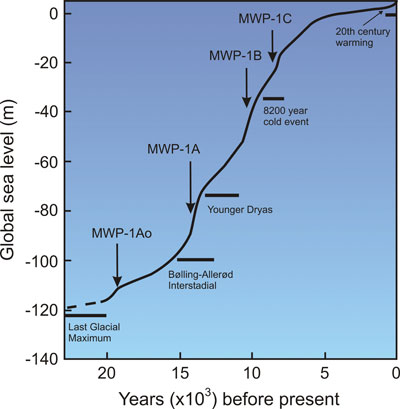
One key piece of evidence cited is the steady rise in sea levels over the last ten thousand years, proving that water continued to occupy the land as enlarged rivers after the ice caps melted. Beyond this general trend, studies focusing on river activity provide more direct support. A scientific paper by Lewis & Macklin (2003) indicates that rivers in Britain experienced over 100 flooding events in the last ten thousand years, some of which lasted for hundreds of years. Another review of radiocarbon-dated fluvial deposits in the UK suggests up to twenty flooding episodes in lowland rivers between 11,190 and 390 cal B.P.20. These numerous flood events are presented as evidence of a significantly higher water table in the past.
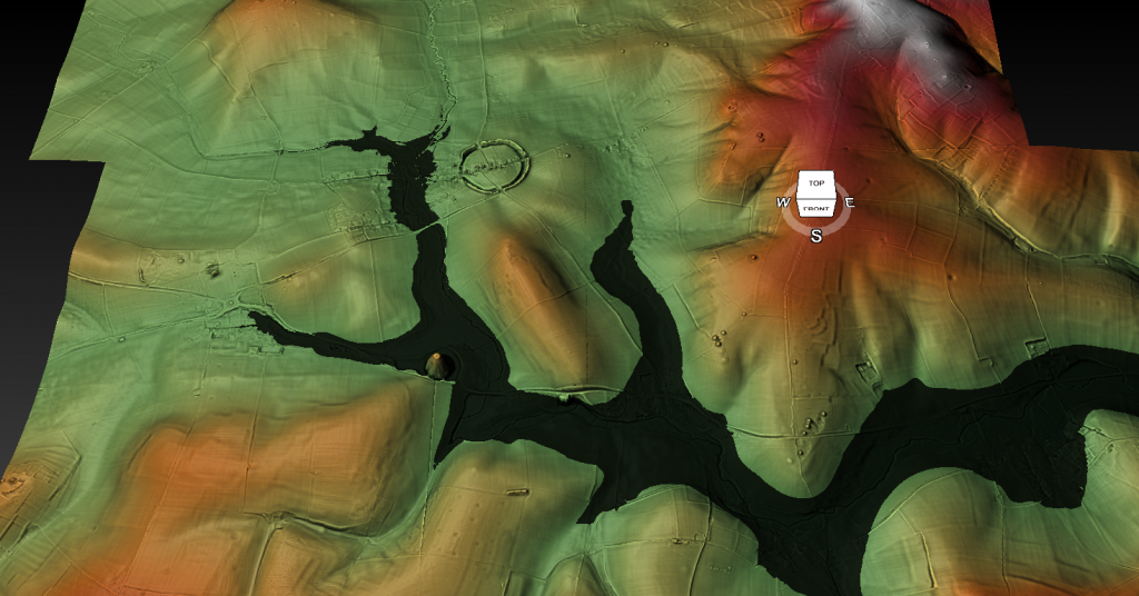
Geological formations such as peat deposits are also considered empirical evidence. Peat forms in wet, marshy ground, and its presence and dating are proof of the extent of the Post-Glacial Flooding and the timing of these episodes. Peat growth is shown to have peaked about 4000 years after the Last Glacial Maximum (LGM), which is interpreted as indicating that rivers remained high and flowing until the Neolithic Period. Modern peatlands are even described as old river beds.

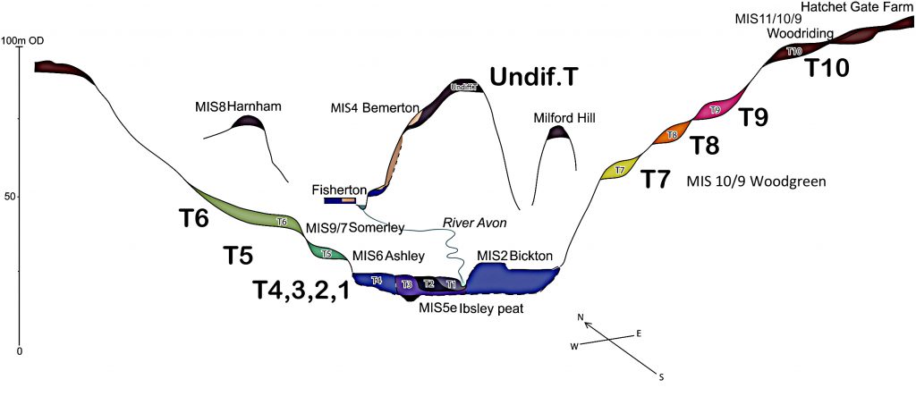
River terraces, remnants of former floodplains, offer further geological insights. The sources note that in the Avon Valley, the terraces between T7 and T10 consist of river silt. Optical Stimulated Luminescence (OSL) dating indicates they are “out of sequence” compared to the traditional geological model. This chronological discrepancy is suspected to result from the numerous flooding events during the Holocene, which would have affected and redeposited sediments on older terraces. Recent OSL dating research in the Avon Valley supports the deposition of T10-7 during or before MIS10/9 (including the LGM).

Analysis of the scale of past river systems provides quantitative evidence. Based on sedimentary data and borehole samples, a case study on the Thames River concluded that its current average discharge rate was potentially increased by 3723% during the Mesolithic and Neolithic periods, reaching a peak discharge of 2450 m³/s. This rate was comparable to smaller North American rivers during the same epoch. Similarly, the Mississippi River’s discharge is noted to have increased from its present rate of 16,790 m³/s to a considerable 160,000 m³/s just after the LGM, an 853% rise indicative of significant augmentation in river height and discharge. Globally, river volumes and heights are estimated to have been, on average, around 941% greater towards the end of the last ice age due to extra water washed down existing terrestrial rivers. Evidence from river terraces, sediment deposits, and paleohydrology supports the idea that rivers were more extensive in the post-glacial period, with major rivers like the Thames and Severn having broader and more dynamic channels.

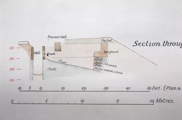
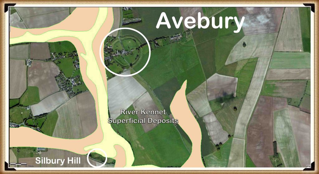
Archaeological sites and features are also interpreted as providing empirical evidence for past higher water levels. The strategic positioning of many prehistoric settlements on higher ground is seen as aligning with the edges of floodplains or higher terraces that would have offered safety from the elevated river levels. The history of sites like Old Sarum is presented as evidence of fluctuating water levels, thriving for approximately 5,000 years (or 4,000) and showing the impact of environmental changes, with its initial abundance of water supporting the notion of much higher levels in prehistoric times. The fact that the Norman well at Old Sarum is now dry is proof of changes in groundwater levels over time. Excavations at Old Sarum also revealed a raised platform and pathway through the outer bank, suggesting the site was accessed by boats on a higher water table during the Neolithic period. Further excavation evidence from the Avebury ditch in 1914, which had to be stopped due to groundwater flooding it and turning it into a moat, is considered a “smoking gun” proving that higher river levels indicated in geological maps would have flooded the ditch. Similarly, an excavation at Hornchurch Marsh, on the edge of the British Geological Survey (BGS) superficial Alluvium flood map, revealed radiocarbon-dated evidence of inundation during the early Holocene, supporting the model of past higher river levels and periodic flooding.
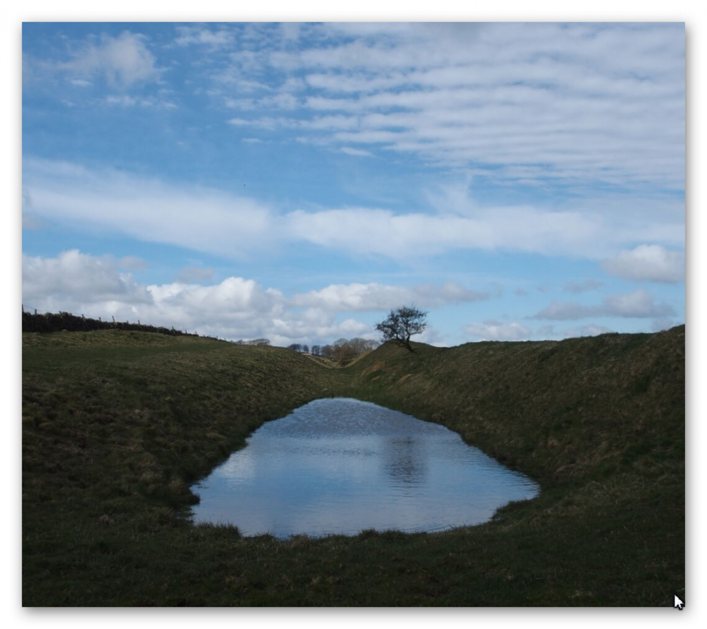
Linear earthworks, commonly known as dykes, are another category of archaeological features offering potential evidence. While traditionally interpreted as boundaries or defensive structures, emerging evidence suggests they may have functioned as prehistoric canals designed for water management and transport within a water-rich landscape. Research indicates that these earthworks can significantly hold and manage water, impacting hydrological connectivity and promoting localized water retention.. An analysis using AI is mentioned, concluding that 8 out of the 10 longest dykes in Britain show empirical evidence of water retainment. Specifically, Wansdyke is noted to incorporate earthworks with right-angled ditches that resemble Roman cross-regulators used for water management, seen at sites like Rybury Camp and Tan Hill. The discrepancy in ditch dimensions between East and West Wansdyke suggests sequential construction linked to changing water levels. Gaps in dykes like Wansdyke and Offa’s Dyke are interpreted as points where ancient, higher rivers coursed through, necessitating a break in the earthwork or requiring boat travel. Excavations by Pitt Rivers are said to reveal that water once flowed through the ditches of Wansdyke. Even Roman structures like Hadrian’s Wall and the Vallum are interpreted as providing evidence; their disappearance for stretches where the landscape would have been flooded by rivers 8m higher than today suggests the structures were routed around these bodies of water, indicating a higher water table even during the Roman period. LiDAR analysis is used to show how structures like henges and potential canals align with past river shorelines or paleochannels associated with higher water levels.
In conclusion, the body of empirical evidence drawn from geological features like peat and river terraces, hydrological data indicating increased river discharge rates, and the characteristics and placement of archaeological sites and linear earthworks (dykes), which are interpreted as supporting the hypothesis of significantly raised river levels in Britain and potentially wider Europe during the Mesolithic and Neolithic periods and extending into later epochs. This perspective challenges traditional archaeological interpretations and suggests a need for re-evaluating ancient landscapes in light of past hydrological conditions. While acknowledging that scientific evidence is always open to reinterpretation, the proponents argue that the collected evidence provides compelling support for this view.
Case Study: Dykes Follow Water: The 68.6% Aquifer Overlap Nobody’s Talking About
Across Britain, prehistoric dykes have long been dismissed as little more than defensive ramparts or mystical boundary markers. But what if we’ve been looking at them through the wrong lens entirely? A new GIS-based study we conducted earlier this year, integrating official British Geological Survey aquifer maps with the known alignments of ancient linear earthworks, reveals something astonishing: 68.6% of dyke segments intersect directly with mapped aquifer zones. That’s not a loose correlation — that’s a direct, measurable pattern that begs for re-evaluation.

This level of overlap seriously undermines the tired narratives of ritual and fortification. Instead, it points to a far more practical purpose — one rooted in hydrology, not mysticism. These dykes, including major features like Offa’s Dyke and Wansdyke, may have been strategically aligned along natural underground water fractures or aquifer boundaries. In this light, their purpose shifts dramatically: from symbolic markers to functioning elements of a water-based transport or irrigation system. Seasonal canal usage, trade facilitation, or even simple water management may have played a central role in their placement.

Overlaying hydrogeological data on ancient dyke networks reveals geometric precision that’s impossible to ignore. These earthworks don’t meander aimlessly — they often shadow aquifer flows, spring lines, and fracture zones. Whether this was achieved through environmental observation, empirical trial and error, or even primitive water divining, it’s clear that prehistoric builders had a working knowledge of what lay beneath their feet. The alignment with hydrological structures is too deliberate to be accidental.

It’s time to abandon the chalky clichés of ritualistic ditches and Saxon scare-lines. This isn’t about spiritual symbolism or defensive paranoia — it’s about engineering, observation, and control of a life-sustaining resource: water. The idea that prehistoric Britons built with such hydrological insight isn’t fantastical — it’s the most logical interpretation of the data. If we start following the water, we might finally start understanding what the dykes were really for.
Case Study: Piercebridge Roman Bridge & the Ancient Tees – A Post-Glacial Perspective
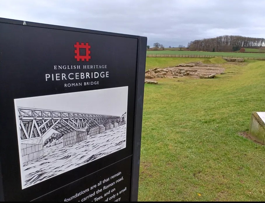
Ever wondered why the Roman bridge at Piercebridge is stranded in a field, far from today’s riverbank?
The answer lies in one of the clearest pieces of physical evidence supporting the Post-Glacial Hypothesis — that Britain’s ancient rivers were not briefly swollen by seasonal flooding but remained massively elevated for thousands of years due to glacial melt, lack of drainage, and a saturated prehistoric climate.
🧱 Roman Engineering Reveals Ancient Water Levels
- Bridge foundations: 58m OD (Ordnance Datum)
- Original bridge deck: likely 6–10m above this = ~64–68m OD
- Standard Roman river clearance: 2–3m ➜ River level: ~61–65m OD
Today, the Tees flows at just ~55m OD, meaning a drop of 6–10m since the Roman era.
But that’s just the start.

🕰️ Rolling Back Time to the Mesolithic (~8000–4000 BC)
With:
- No flood defences
- Heavy glacial runoff
- Slow-draining forested valleys
A conservative model of ~5m drop every 2000 years means the Tees in the Mesolithic likely flowed at ~70–75m OD — up to 20m higher than today.

💡 What It All Proves
This isn’t just a minor fluctuation.
It’s geological proof that prehistoric rivers were immense — wide, high, and capable of supporting boat-based transport across much of Britain. That changes how we interpret:
- “Hillforts” (which may have been river-edge settlements)
- Prehistoric trade and transport networks
- Sites like Stonehenge, where the River Avon (currently at 68m OD) was likely much higher — supporting the theory of bluestone delivery by boat
Piercebridge is no anomaly — it’s a smoking gun.
Case Study – The Thames
The Lower Thames sequence has been thoroughly studied not only because it is one of the largest river systems in the country but also because of its fortuitous exposure in many of the quarries and recent development programmes in and around London. The Thames was diverted into its current valley during the Anglian period where it proceeded to lay down extensive gravel deposits before reaching the sea. Archaeological interest in the Thames alluvial deposits and the raised beaches of the south-east coast is also due to the presence of significant Lower, and Middle Palaeolithic artefacts and hominin remains within these deposits.
The depositional chronology of the Thames gravel terraces has yet to be universally accepted, and the two significant sequences have been proposed by Gibbard (1985) and Bridgland (1994). This is because the terraces are dated by the artefacts found within them which are archaeologically dated and not carbon dated. The problem with this method is that if the area flooded after the original deposits were laid down, the artefacts could have been washed down from upstream and embedded at random.
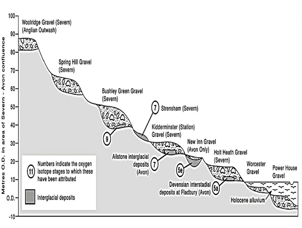
| Traditional View of the Thames River terraces |
The modern floodplain of the Lower Thames, downstream of central London, is bounded either by older Pleistocene sands or gravels at the higher levels or by bedrock. The depositional chronology of the Thames gravel terraces has yet to be universally accepted, and the two significant sequences have been proposed by (Gibbard, 1985).
The SBAB model of floodplain evolution proposes that during the early Holocene multi-channel braided systems stabilised with the narrowing and deepening of some channels, and the progressive abandonment of others over the course of the Holocene (Brown et al. 1994).
The Lower Thames saw a rise of about 15m in relative sea level between c. 10,000, and c. 6000 BP (Rackham and Sidell, 2000; Sidell 2003b). This would have had a significant effect upon settlement of the outer and mid estuary floodplain. It has been suggested, for example, that settlement areas along the river margin progressively moved to higher ground as the land below was overtaken by the rising water levels (Rackham and Sidell 2000).
During the early Holocene, the Lower Thames floodplain was a complex environment of peat-forming areas, migrating channels and raised eyots (Sidell 2003a). Often these eyots were the focus of prehistoric occupation, for example, Runnymede (Needham 1991; 1992), Westminster, Southwark (Bowsher 1991; Dillion et al. 1991; Merriman 1992) and Bermondsey (Sidell et al. 2002). These areas tended to lie at the junction between the higher ground on the edge of an island and the adjacent peat and alluvium, which preserved the evidence of human activity that took place when the river levels were lower (Merriman 1992; Sidell et al. 2002).
The investigations carried out for the Jubilee Line extension have suggested that the sand eyots of Westminster and north Southwark did not complete their formation by the early Holocene as initially believed. Still, instead, they formed in the mid-Neolithic (c. 3500 cal B.C.). This could help explain why there is a lack of Early Neolithic occupation in the floodplain (Sidell 2003b).
An extensive number of boreholes (> 1100) have allowed the British Geological Society to map the extent of flooding in the early Holocene period as it left extensive alluvium up to 10m deep in places showing the vast duration of the raised water levels.
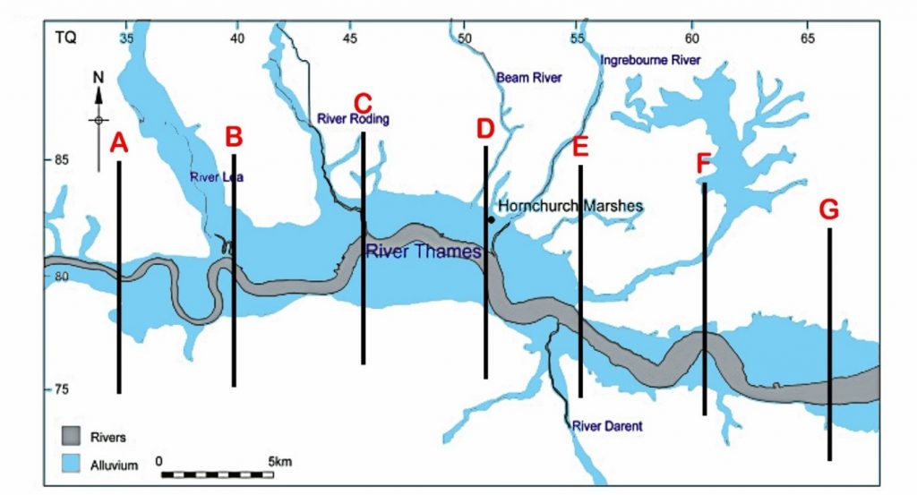
| BGS Map of London showing in blue the Alluvium deposited at the end of the LGM. We have sectioned off A- G areas to look at their cross-sections. |
If we section off (A to G) the Thames and look at the volume and width of the Holocene Thames in comparison to today, we can get an estimation of the discharge of water at its peak during this period.
Increased discharge levels during the Holocene
| Cross- Section | Current Width | Holocene Width | Width Increase % | Volume Increase – (Holo. – Present =) Cu.m3 | Increase in Volume |
| A | 400m | 4,425m | 1,100 | 71,724 – 800 = 70,924 | 8,866% |
| B | 650m | 7,725m | 1,188 | 71,950 – 1950 = 70,000 | 3,590% |
| C | 731m | 8,450m | 1,156 | 128,430 – 2924 = 125,506 | 4,292% |
| D | 965m | 7,644m | 792 | 60,348 – 4825 = 55,523 | 1,151% |
| E | 1,207m | 11,265m | 933 | 90,122 – 7274 = 82,880 | 7,367% |
| F | 1,125m | 5,230m | 465 | 38,622 – 7875 = 30,747 | 390% |
| G | 1,448m | 7,242m | 500 | 58,902 – 11584 = 47318 | 408% |
| Average | 932m | 7426m | 797% | 3723% |

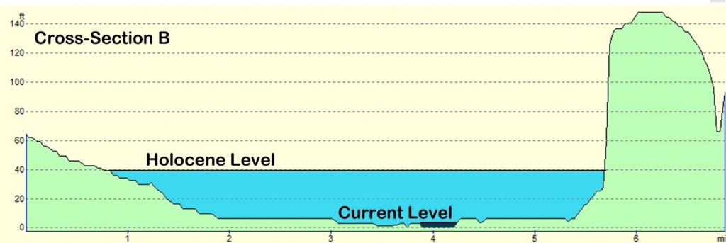


| Thames River Cross-Sections A – G |
The current average discharge is 65.8 m³/s and therefore with a 3723% increase in the watershed area we can estimate that at its peak the Thames River discharged 2450 m3/s (0.0025 Gt /s or 1314 Gt per annum).
About the same rate of one of the smaller rivers ‘Susquehanna/Chesapeake River’ (Table 5) in North America – which is minor, in comparison to the eight North American river discharge ratios, which begs the question as the Thames is the largest river in the country, would it not be affected mostly by the meltwater at the end of the last ice age – so, have the scientists got the extent of the alluvium flooding correct?
To investigate further, we need to look at a detailed excavation undertaken at the edge of the BGS superficial Alluvium flood map to get some real evidence of dates and clues about what sediments are present in comparison to the ages suggested in the past publications.
‘Holocene environmental changes in the Lower Thames Valley’ (Branch et al.,2012) excavated parts of Hornchurch marsh at the edge of the BSG alluvium deposit (Cross-Section D).
The paper suggests that “Palaeoenvironmental data (publicly or in the form of commercial archaeological reports) on these near-surface sediments indicate that following the end of the last glaciation, the lower reaches of the Thames Valley and its tributaries were inundated by the sea, and marine and estuarine sediments accumulated. Since that time, the evidence suggests that sea level continued to rise at a much slower rate as a response to either glacio-eustatic or sedimentary processes”. But the idea of any recent “inundation by the sea” can now be easily rebuked.
The reason for this incorrect interpretation of sediments was that past Geologists believed that the LGM was much smaller than previous ice ages – this has now been disproved by new research at sea level data from the Mediterranean (Rohling et al., 2017) as they could only measure by observation the extent of the ice sheets on the surface of the landmass and took for granted the greater the area, the larger the ice mass by estimation.
The conclusion of this study is to show that the last Ice Age was far more significant than previously maximum (PCM) as illustrated below in table 6 and Fig. 30)
Ten Frequently Asked Questions
1. If the sea level was so high, wouldn’t people in the past have drowned?
This question reflects a misunderstanding of hydrology. The elevation of a river is not directly linked to sea level. Rivers flow primarily from aquifers—water reservoirs embedded within bedrock—not from just rainfall as commonly taught in schools. These aquifers dictate water flow through natural springs, independent of sea level.
Unfortunately, even prominent figures in archaeology have misunderstood this principle. For instance, one well-known archaeologist dismissed my findings by dubbing the book the “Stonehenge on Sea” hypothesis – based solely on the book’s cover. This misinterpretation highlights the importance of engaging with the underlying science rather than relying on superficial impressions. (The Rivers of the Past were Higher)

2. If sea levels in the past were lower, how could rivers be higher?
During the last ice age, sea levels were approximately 65 meters lower than today. However, the colder climate meant precipitation fell as snow, forming massive glaciers. These glaciers trapped vast amounts of water, preventing it from flowing into rivers.
When the glaciers began to melt, the water released caused rivers to swell dramatically. This wasn’t a quick process. Recent models show that sea levels rose over 7,000 years after the initial melt, transforming landscapes like Doggerland—a land bridge connecting Britain to Europe—into the North Sea. This extended period of flooding explains how rivers could have been significantly larger in the past, despite lower sea levels.
3. Why aren’t all rivers and tributaries the same height in this area?
The simplistic notion that water “always seeks a common level” misrepresents the complexities of hydrology. Multiple aquifers at varying elevations feed rivers, and their flow mirrors the contours of the landscape. This intricate system ensures that rivers don’t conform to a uniform height.
For instance, rivers like the Thames have multiple sources that contribute to their flow. Even when rainfall is scarce, aquifers release water at different elevations, sustaining the river. This dynamic interplay explains why rivers don’t follow a universal level and why one river may sit higher than another in the same region.
4. Is this hypothesis based on fact or just speculation?
The hypothesis is firmly grounded in decades of research and fieldwork. It builds on three decades of academic study and exploration, culminating in an academic thesis supported by 125 peer-reviewed references.

5. I’ve walked these routes and found no water. How do you explain that?
Landscapes are dynamic, not static. Ten thousand years ago, the Sahara was a lush rainforest filled with elephants and lions. Similarly, Britain’s east coast was once a verdant plain connecting it to Europe. Over millennia, these landscapes changed dramatically due to shifting climates and sea levels.
Rivers that once flowed abundantly have since diminished as aquifers dried up. For example, the North Sea, Irish Sea, and English Channel gradually drained the rivers that fed them, lowering water tables and drying out springs in elevated areas. Today, you see a shadow of the ancient hydrological systems that once defined these regions.

6. Why would people push boats to the top of a hillfort?
The idea that ancient people moved boats uphill reflects a misunderstanding of how rivers once shaped the landscape. According to the hypothesis, ancient rivers like the Thames were vastly larger—potentially 3,000 times their current size. What we perceive as hills today would have appeared as islands within these expansive waterways.
Earthworks along these rivers likely defined the edges of these elevated landforms, making them accessible by boat. This perspective challenges modern assumptions about the topography of the past and highlights the transformative role of ancient hydrological systems.

7. Where is the evidence for larger rivers in the past?
British Geological Survey maps provide compelling evidence of ancient, larger rivers. These maps detail the extent of superficial deposits that mark the waterways’ historical boundaries. Features like river terraces further support this evidence.
For instance, the River Avon has ten terraces, indicating its past size and elevation. At one time, this river spanned tens of kilometres in width and was over 100 meters above current sea level. These geological features attest to the dynamic nature of rivers throughout history. (The Rivers of the Past were Higher)
8. I have a PhD in archaeology—why wasn’t I taught this?
Archaeological education has traditionally focused on specific methodologies while neglecting interdisciplinary approaches. In the 21st century, good archaeology requires integrating hydrology, dating methods, and advanced mapping techniques like LiDAR.
LiDAR, for instance, allows us to reconstruct ancient landscapes with remarkable precision. Yet, many archaeologists lack the training to interpret raw LiDAR data or understand its full potential. The absence of such knowledge limits their ability to engage with complex hypotheses like the one presented here. Archaeology must evolve into a more scientifically robust discipline to address this gap. (The Rivers of the Past were Higher)
9. Water can’t flow uphill, for the gradients are too high
This question reflects a common misconception about the nature and purpose of prehistoric linear earthworks, or “dykes,” in a flooded prehistoric landscape. Many people mistakenly interpret these structures through the lens of Victorian canals, imagining them as continuous waterways designed to transport goods over long distances in a single, uninterrupted flow. This comparison oversimplifies the engineering principles and functional realities of prehistoric dykes. (The Rivers of the Past were Higher)
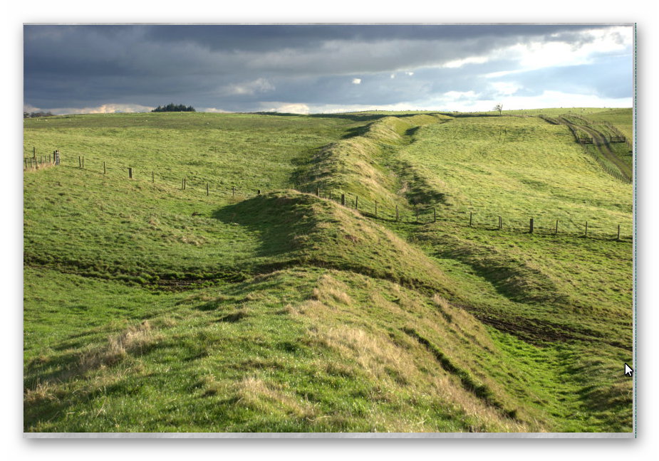
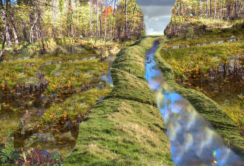
In prehistory, river levels were significantly higher than today, which meant that the distances goods needed to travel over land were much shorter. Prehistoric dykes were not designed as continuous waterways; instead, they were engineered to serve as efficient connections between rivers or to transport raw materials from quarries to waterways. These materials could then be transported by boat to trading sites or processing locations.
A key feature of these dykes is their adaptability to the landscape. Unlike Victorian canals, which relied on a continuous channel of water and locks to maintain flow, prehistoric dykes often utilized natural springs at the tops of hills. These springs could provide water that flowed down both sides of a hill, enabling transport without the need to “go over” the hill itself. This ingenious use of natural water sources allowed for movement between points A and B most efficiently, considering the terrain and hydrology of the time. (The Rivers of the Past were Higher)
10. How can you connect to other rivers as you need to go over the hill?
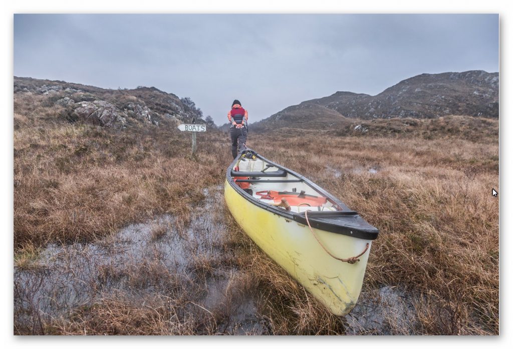
In cases where goods or people needed to traverse a hill with water flowing down both sides, the solution was remarkably straightforward and practical. A boat or barge, naturally floating in the water and much lighter to manage than carrying goods or loads overland, could be dragged uphill using workforce or, more efficiently, animal power. Oxen, for example, would have been ideal for towing boats up gradients along the dyke.
Once the summit was reached, the natural downhill flow of water could take over, allowing the boat to continue its journey easily. Using animal power to drag boats uphill echoes practices seen in early Victorian canal systems. During this period, weirs were often constructed to slow water flow in downhill rivers, facilitating the towing of barges and boats uphill. The principle was straightforward: use animal power for uphill transport and natural flow for downhill movement, ensuring efficiency and minimizing the physical burden on workers.
This method would have effectively transported goods or people over varied terrain in a prehistoric context, leveraging both natural hydrology and available resources like animal labour. The adaptability of this system highlights the innovative and pragmatic approaches of ancient societies to overcome challenges posed by their environment.
By viewing prehistoric dykes through this lens, we can better appreciate their functionality and the ingenuity of those who designed them. Modern assumptions of continuous waterways did not limit these structures but reflected a deep understanding of the landscape and the tools available to navigate it. (The Rivers of the Past were Higher)
Conclusion
The Post-Glacial Flooding Hypothesis challenges conventional wisdom about ancient landscapes and hydrology. It invites us to reconsider the evidence and embrace a more interdisciplinary approach to archaeology. While the journey to broader acceptance has been fraught with resistance and misunderstanding, the evidence speaks for itself.
For those willing to engage deeply, the hypothesis offers a transformative lens to understand the past—a perspective rooted in science, shaped by rigorous research, and open to thoughtful debate.
Scientific progress begins with hypotheses. I welcome questions and challenges, but they must be substantiated with evidence. The burden of proof lies with those who disagree, requiring more than opinion; it demands well-referenced counterarguments. This process of scrutiny and debate is the essence of scientific advancement.
The landscape has changed — but the clues are still there, in stone, in soil, and in elevation maps. It’s time archaeology stopped ignoring the water and started reimagining the prehistoric world from the riverbed up. (The Rivers of the Past were Higher)

(The Rivers of the Past were Higher)
Exploring Prehistoric Britain: A Journey Through Time
My blog delves into the fascinating mysteries of prehistoric Britain, challenging conventional narratives and offering fresh perspectives based on cutting-edge research, particularly using LiDAR technology. I invite you to explore some key areas of my research. For example, the Wansdyke, often cited as a defensive structure, is re-examined in light of new evidence. I’ve presented my findings in my blog post Wansdyke: A British Frontier Wall – ‘Debunked’, and a Wansdyke LiDAR Flyover video further visualizes my conclusions.
My work also often challenges established archaeological dogma. I argue that many sites, such as Hambledon Hill, commonly identified as Iron Age hillforts are not what they seem. My posts Lidar Investigation Hambledon Hill – NOT an ‘Iron Age Fort’ and Unmasking the “Iron Age Hillfort” Myth explore these ideas in detail and offer an alternative view. Similarly, sites like Cissbury Ring and White Sheet Camp, also receive a re-evaluation based on LiDAR analysis in my posts Lidar Investigation Cissbury Ring through time and Lidar Investigation White Sheet Camp, revealing fascinating insights into their true purpose. I have also examined South Cadbury Castle, often linked to the mythical Camelot56.
My research also extends to the topic of ancient water management, including the role of canals and other linear earthworks. I have discussed the true origins of Car Dyke in multiple posts including Car Dyke – ABC News PodCast and Lidar Investigation Car Dyke – North Section, suggesting a Mesolithic origin2357. I also explore the misidentification of Roman aqueducts, as seen in my posts on the Great Chesters (Roman) Aqueduct. My research has also been greatly informed by my post-glacial flooding hypothesis which has helped to inform the landscape transformations over time. I have discussed this hypothesis in several posts including AI now supports my Post-Glacial Flooding Hypothesis and Exploring Britain’s Flooded Past: A Personal Journey
Finally, my blog also investigates prehistoric burial practices, as seen in Prehistoric Burial Practices of Britain and explores the mystery of Pillow Mounds, often mistaken for medieval rabbit warrens, but with a potential link to Bronze Age cremation in my posts: Pillow Mounds: A Bronze Age Legacy of Cremation? and The Mystery of Pillow Mounds: Are They Really Medieval Rabbit Warrens?. My research also includes the astronomical insights of ancient sites, for example, in Rediscovering the Winter Solstice: The Original Winter Festival. I also review new information about the construction of Stonehenge in The Stonehenge Enigma.
(The Rivers of the Past were Higher)
Further Reading
For those interested in British Prehistory, visit www.prehistoric-britain.co.uk, a comprehensive resource featuring an extensive collection of archaeology articles, modern LiDAR investigations, and groundbreaking research. The site also includes insights and extracts from the acclaimed Robert John Langdon Trilogy, a series of books exploring Britain during the Prehistoric period. Titles in the trilogy include The Stonehenge Enigma, Dawn of the Lost Civilisation, and The Post Glacial Flooding Hypothesis, offering compelling evidence about ancient landscapes shaped by post-glacial flooding.
To further explore these topics, Robert John Langdon has developed a dedicated YouTube channel featuring over 100 video documentaries and investigations that complement the trilogy. Notable discoveries and studies showcased on the channel include 13 Things that Don’t Make Sense in History and the revelation of Silbury Avenue – The Lost Stone Avenue, a rediscovered prehistoric feature at Avebury, Wiltshire.
In addition to his main works, Langdon has released a series of shorter, accessible publications, ideal for readers delving into specific topics. These include:
- The Ancient Mariners
- Stonehenge Built 8300 BCE
- Old Sarum
- Prehistoric Rivers
- Dykes, Ditches, and Earthworks
- Echoes of Atlantis
- Homo Superior
- 13 Things that Don’t Make Sense in History
- Silbury Avenue – The Lost Stone Avenue
- Offa’s Dyke
- The Stonehenge Enigma
- The Post-Glacial Flooding Hypothesis
- The Stonehenge Hoax
- Dawn of the Lost Civilisation
- Darwin’s Children
- Great Chester’s Roman Aqueduct
- Wansdyke
For active discussions and updates on the trilogy’s findings and recent LiDAR investigations, join our vibrant community on Facebook. Engage with like-minded enthusiasts by leaving a message or contributing to debates in our Facebook Group.
Whether through the books, the website, or interactive videos, we aim to provide a deeper understanding of Britain’s fascinating prehistoric past. We encourage you to explore these resources and uncover the mysteries of ancient landscapes through the lens of modern archaeology.
For more information, including chapter extracts and related publications, visit the Robert John Langdon Author Page. Dive into works such as The Stonehenge Enigma or Dawn of the Lost Civilisation, and explore cutting-edge theories that challenge traditional historical narratives.
(The Rivers of the Past were Higher)
Other Blogs
1
a
- AI now Supports – Homo Superior
- AI now supports my Post-Glacial Flooding Hypothesis
- Alexander the Great sailed into India – where no rivers exist today
- Ancient Prehistoric Canals – The Vallum
- Ancient Secrets of Althorp – debunked
- Antler Picks built Ancient Monuments – yet there is no real evidence
- Antonine Wall – Prehistoric Canals (Dykes)
- Archaeological ‘pulp fiction’ – has archaeology turned from science?
- Archaeological Pseudoscience
- Archaeology in the Post-Truth Era
- Archaeology: A Bad Science?
- Archaeology: A Harbour for Fantasists?
- Archaeology: Fact or Fiction?
- Archaeology: The Flaws of Peer Review
- Archaeology’s Bayesian Mistake: Stop Averaging the Past
- Are Raised Beaches Archaeological Pseudoscience?
- Atlantis Found: The Mathematical Proof That Plato’s Lost City Was Doggerland
- ATLANTIS: Discovery with Dan Snow Debunked
- Avebury Ditch – Avebury Phase 2
- Avebury Post-Glacial Flooding
- Avebury through time
- Avebury’s great mystery revealed
- Avebury’s Lost Stone Avenue – Flipbook
b
- Battlesbury Hill – Wiltshire
- Beyond Stone and Bone: Rethinking the Megalithic Architects of Northern Europe
- BGS Prehistoric River Map
- Blackhenge: Debunking the Media misinterpretation of the Stonehenge Builders
- Brain capacity (Cro-Magnon Man)
- Brain capacity (Cro-Magnon Man)
- Britain’s First Road – Stonehenge Avenue
- Britain’s Giant Prehistoric Waterways
- British Roman Ports miles away from the coast
c
- Caerfai Promontory Fort – Archaeological Nonsense
- Car Dyke – ABC News PodCast
- Car Dyke – North Section
- CASE STUDY – An Inconvenient TRUTH (Craig Rhos Y Felin)
- Case Study – River Avon
- Case Study – Woodhenge Reconstruction
- Chapter 2 – Craig Rhos-Y-Felin Debunked
- Chapter 2 – Stonehenge Phase I
- Chapter 2 – Variation of the Species
- Chapter 3 – Post Glacial Sea Levels
- Chapter 3 – Stonehenge Phase II
- Chapter 7 – Britain’s Post-Glacial Flooding
- Cissbury Ring through time
- Cro-Magnon Megalithic Builders: Measurement, Biology, and the DNA
- Cro-Magnons – An Explainer
d
- Darwin’s Children – Flipbook
- Darwin’s Children – The Cro-Magnons
- Dawn of the Lost Civilisation – Flipbook
- Dawn of the Lost Civilisation – Introduction
- Digging for Britain – Cerne Abbas 1 of 2
- Digging for Britain Debunked – Cerne Abbas 2
- Digging Up Britain’s Past – Debunked
- DLC Chapter 1 – The Ascent of Man
- Durrington Walls – Woodhenge through time
- Durrington Walls Revisited: Platforms, Fish Traps, and a Managed Mesolithic Landscape
- Dyke Construction – Hydrology 101
- Dykes Ditches and Earthworks
- DYKES of Britain
e
f
g
h
- Hadrian’s Wall – Military Way Hoax
- Hadrian’s Wall – the Stanegate Hoax
- Hadrian’s Wall LiDAR investigation
- Hambledon Hill – NOT an ‘Iron Age Fort’
- Hayling Island Lidar Maps
- Hidden Sources of Ancient Dykes: Tracing Underground Groundwater Fractals
- Historic River Avon
- Hollingsbury Camp Brighton
- Hollows, Sunken Lanes and Palaeochannels
- Homo Superior – Flipbook
- Homo Superior – History’s Giants
- How Lidar will change Archaeology
i
l
m
- Maiden Castle through time
- Mathematics Meets Archaeology: Discovering the Mesolithic Origins of Car Dyke
- Mesolithic River Avon
- Mesolithic Stonehenge
- Minerals found in Prehistoric and Roman Quarries
- Mining in the Prehistoric to Roman Period
- Mount Caburn through time
- Mysteries of the Oldest Boatyard Uncovered
- Mythological Dragons – a non-existent animal that is shared by the World.
o
- Offa’s Dyke Flipbook
- Old Sarum Lidar Map
- Old Sarum Through Time…………….
- On Sunken Lands of the North Sea – Lived the World’s Greatest Civilisation.
- OSL Chronicles: Questioning Time in the Geological Tale of the Avon Valley
- Oswestry LiDAR Survey
- Oswestry through time
- Oysters in Archaeology: Nature’s Ancient Water Filters?
p
- Pillow Mounds: A Bronze Age Legacy of Cremation?
- Post Glacial Flooding – Flipbook
- Prehistoric Burial Practices of Britain
- Prehistoric Canals – Wansdyke
- Prehistoric Canals – Wansdyke
- Prehistoric Canals (Dykes) – Great Chesters Aqueduct (The Vallum Pt. 4)
- Prehistoric Canals (Dykes) – Hadrian’s Wall Vallum (pt 1)
- Prehistoric Canals (Dykes) – Offa’s Dyke (Chepstow)
- Prehistoric Canals (Dykes) – Offa’s Dyke (LiDAR Survey)
- Prehistoric Canals (Dykes) – Offa’s Dyke Survey (End of Section A)
- Prehistoric Canals (Dykes) – Wansdyke (4)
- Prehistoric Canals Wansdyke 2
- Professor Bonkers and the mad, mad World of Archaeology
r
- Rebirth in Stone: Decrypting the Winter Solstice Legacy of Stonehenge
- Rediscovering the Winter Solstice: The Original Winter Festival
- Rethinking Ancient Boundaries: The Vallum and Offa’s Dyke”
- Rethinking Ogham: Could Ireland’s Oldest Script Have Begun as a Tally System?
- Rethinking The Past: Mathematical Proof of Langdon’s Post-Glacial Flooding Hypothesis
- Revolutionising History: Car Dyke Unveiled as Prehistoric & the Launch of FusionBook 360
- Rising Evidence, Falling Rivers: The Real Story of Europe’s First Farmers
- Rivers of the Past Were Higher: A Fresh Perspective on Prehistoric Hydrology
s
- Sea Level Changes
- Section A – NY26SW
- Section B – NY25NE & NY26SE
- Section C – NY35NW
- Section D – NY35NE
- Section E – NY46SW & NY45NW
- Section F – NY46SE & NY45NE
- Section G – NY56SW
- Section H – NY56NE & NY56SE
- Section I – NY66NW
- Section J – NY66NE
- Section K – NY76NW
- Section L – NY76NE
- Section M – NY87SW & NY86NW
- Section N – NY87SE
- Section O – NY97SW & NY96NW
- Section P – NY96NE
- Section Q – NZ06NW
- Section R – NZ06NE
- Section S – NZ16NW
- Section T – NZ16NE
- Section U – NZ26NW & NZ26SW
- Section V – NZ26NE & NZ26SE
- Silbury Avenue – Avebury’s First Stone Avenue
- Silbury Hill
- Silbury Hill / Sanctuary – Avebury Phase 3
- Somerset Plain – Signs of Post-Glacial Flooding
- South Cadbury Castle – Camelot
- Statonbury Camp near Bath – an example of West Wansdyke
- Stone me – the druids are looking the wrong way on Solstice day
- Stone Money – Credit System
- Stone Transportation and Dumb Censorship
- Stonehenge – Monument to the Dead
- Stonehenge Hoax – Dating the Monument
- Stonehenge Hoax – Round Monument?
- Stonehenge Hoax – Summer Solstice
- Stonehenge LiDAR tour
- Stonehenge Phase 1 — Britain’s First Monument
- Stonehenge Phase I (The Stonehenge Landscape)
- Stonehenge Solved – Pythagorean maths put to use 4,000 years before he was born
- Stonehenge Stone Transportation
- Stonehenge Through Time
- Stonehenge, Doggerland and Atlantis connection
- Stonehenge: Discovery with Dan Snow Debunked
- Stonehenge: The Worlds First Computer
- Stonehenge’s The Lost Circle Revealed – DEBUNKED
t
- Ten Reasons Why Car Dyke Blows Britain’s Earthwork Myths Out of the Water
- Ten Things You Didn’t Know About Britain’s Prehistoric Flooded Past
- Ten thousand year old boats found on Northern Europe’s Hillsides
- Ten thousand-year-old boats found on Northern Europe’s Hillsides
- The “Hunter-Gatherer” Myth: Why It’s Time to Bury This Outdated Term
- The Ancient Mariners – Flipbook
- The Ancient Mariners – Prehistoric seafarers of the Mesolithic
- The Beringian Migration Myth: Why the Peopling of the Americas by Foot is Mathematically and Logistically Impossible
- The Bluestone Enigma
- The Cro-Magnon Cover-Up: How DNA and PR Labels Erased Our Real Ancestry
- The Dolmen and Long Barrow Connection
- The Durrington Walls Hoax – it’s not a henge?
- The Dyke Myth Collapses: Excavation and Dating Prove Britain’s Great Dykes Are Prehistoric Canals
- The First European Smelted Bronzes
- The Fury of the Past: Natural Disasters in Historical and Prehistoric Britain
- The Giant’s Graves of Cumbria
- The Giants of Prehistory: Cro-Magnon and the Ancient Monuments
- The Great Antler Pick Hoax
- The Great Chichester Hoax – A Bridge too far?
- The Great Dorchester Aqueduct Hoax
- The Great Farming Hoax – (Einkorn Wheat)
- The Great Farming Migration Hoax
- The Great Hadrian’s Wall Hoax
- The Great Iron Age Hill Fort Hoax
- The Great Offa’s Dyke Hoax
- The Great Prehistoric Migration Hoax
- The Great Stone Transportation Hoax
- The Great Stonehenge Hoax
- The Great Wansdyke Hoax
- The Henge and River Relationship
- The Logistical Impossibility of Defending Maiden Castle
- The Long Barrow and Dolman Enigma
- The Long Barrow Mystery
- The Long Barrow Mystery: Unravelling Ancient Connections
- The Lost Island of Avalon – revealed
- The Maiden Way Hoax – A Closer Look at an Ancient Road’s Hidden History
- The Maths – LGM total ice volume
- The Mystery of Pillow Mounds: Are They Really Medieval Rabbit Warrens?
- The Old Sarum Hoax
- The Oldest Boat Yard in the World found in Wales
- The Perils of Paradigm Shifts: Why Unconventional Hypotheses Get Branded as Pseudoscience
- The Post-Glacial Flooding Hypothesis – Flipbook
- The Post-Glacial Flooding Theory
- The Problem with Hadrian’s Vallum
- The Rise of the Cro-Magnon (Homo Superior)
- The Roman Military Way Hoax
- The Silbury Hill Lighthouse?
- The Stonehenge Avenue
- The Stonehenge Avenue
- The Stonehenge Code: Unveiling its 10,000-Year-Old Secret
- The Stonehenge Enigma – Flipbook
- The Stonehenge Enigma: What Lies Beneath? – Debunked
- The Stonehenge Hoax – Bluestone Quarry Site
- The Stonehenge Hoax – Flipbook
- The Stonehenge Hoax – Moving the Bluestones
- The Stonehenge Hoax – Periglacial Stripes
- The Stonehenge Hoax – Station Stones
- The Stonehenge Hoax – Stonehenge’s Location
- The Stonehenge Hoax – The Ditch
- The Stonehenge Hoax – The Slaughter Stone
- The Stonehenge Hoax – The Stonehenge Layer
- The Stonehenge Hoax – Totem Poles
- The Stonehenge Hoax – Woodhenge
- The Stonehenge Hospital
- The Subtropical Britain Hoax
- The Troy, Hyperborea and Atlantis Connection
- The Vallum @ Hadrian’s Wall – it’s Prehistoric!
- The Vallum at Hadrian’s Wall (Summary)
- The Woodhenge Hoax
- Three Dykes – Kidland Forest
- Top Ten misidentified Fire Beacons in British History
- Troy Debunked
- TSE – DVD Barrows
- TSE DVD – An Inconvenient Truth
- TSE DVD – Antler Picks
- TSE DVD – Avebury
- TSE DVD – Durrington Walls & Woodhenge
- TSE DVD – Dykes
- TSE DVD – Epilogue
- TSE DVD – Stonehenge Phase I
- TSE DVD – Stonehenge Phase II
- TSE DVD – The Post-Glacial Hypothesis
- TSE DVD Introduction
- TSE DVD Old Sarum
- Twigs, Charcoal, and the Death of the Saxon Dyke Myth
w
- Wansdyke – Short Film
- Wansdyke East – Prehistoric Canals
- Wansdyke Flipbook
- Wansdyke LiDAR Flyover
- Wansdyke: A British Frontier Wall – ‘Debunked’
- Was Columbus the first European to reach America?
- What Archaeology Missed Beneath Stonehenge
- White Sheet Camp
- Why a Simple Fence Beats a Massive Dyke (and What That Means for History)
- Windmill Hill – Avebury Phase 1
- Winter Solstice – Science, Propaganda and Indoctrination
- Woodhenge – the World’s First Lighthouse?
(The Rivers of the Past were Higher)





Pingback: 2024 Prehistoric Britain Blog Review - Prehistoric Britain