Cardigan Bay: The Holocene Evidence the Old Geological Story Has Missed
LiDAR, radiocarbon dating and peer-reviewed sedimentary studies are beginning to reveal the scale and duration of Britain’s lost post-glacial hydrological landscape

Prehistoric Britain from 2027 membership starts from just 99p per month, with extensive searchable maps, videos, podcasts and references to the underlying data.
For years, the Post-Glacial Flooding Hypothesis has argued that we have been looking at Britain’s post-Ice-Age landscape at the wrong scale.
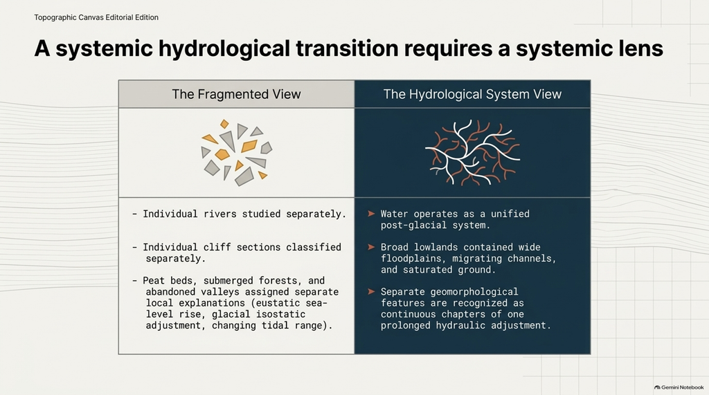
Individual rivers are studied separately.
Individual cliff sections are classified separately.
Peat beds, submerged forests, terraces, flood deposits and abandoned valleys are assigned separate explanations.
But water does not operate as a collection of isolated archaeological sites.
It operates as a system.
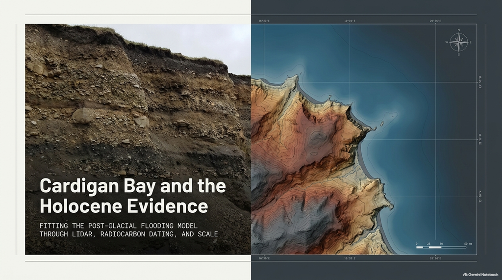
And Cardigan Bay may now provide one of the clearest examples yet of what happens when we stop looking at individual deposits and begin looking at the entire hydrological landscape.
This investigation began with a simple observation on the Cardigan Bay coast.
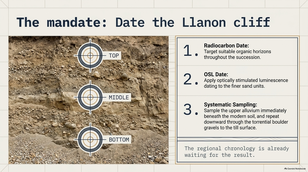
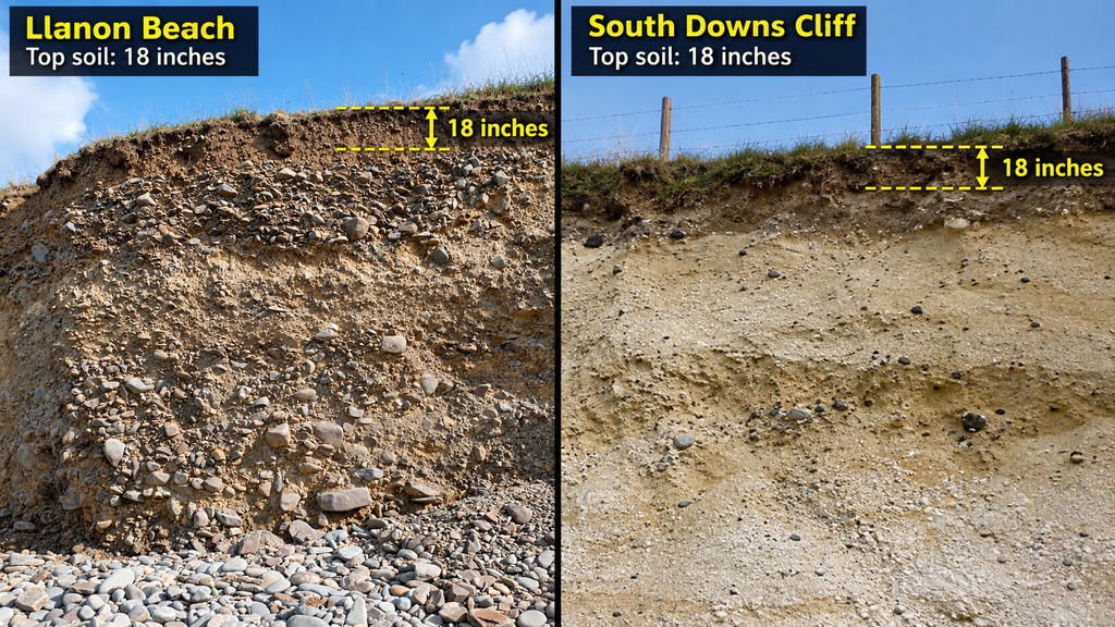
A cliff approximately four and a half metres high.
Only around eighteen inches of relatively undisturbed modern soil at the top.
And beneath it, metres of gravels, sediments and substantial cobbles.
Initially, I wanted to know whether these were really water-laid deposits.
That question has now effectively disappeared.
Published geology already describes the Llanon sequence as almost entirely alluvial gravel and specifically records “torrential alluvial boulder gravels.”
So powerful flowing water is not my interpretation.
It is already part of the published geological description.
The important question is now much bigger.
When did this enormous water system operate — and how long did it survive?
Llanon: The Water Is Already Proven
Llanon is not an obscure cliff that has escaped geological attention.
It is a recognised Geological Conservation Review site.
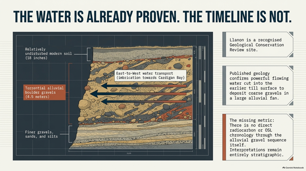
The principal sections between the Peris and Clydan rivers are described as approximately 3.5 to 4.5 metres high and almost entirely composed of alluvial gravels.
The published succession contains Welsh till, Irish Sea till, torrential alluvial boulder gravels, and then finer gravels, sands and silts.
The same account records that precursors of the Peris and Clydan rivers cut into the earlier till surface and deposited coarse gravels in a large alluvial fan.
Where the gravels remain undisturbed, their imbrication shows transport from east to west — towards Cardigan Bay.
That is an exceptionally important starting point.
We do not have to prove that water transported these deposits.
The geological literature has already done that.
We do not have to prove that the water was energetic.
The literature itself calls part of the sequence torrential.
The uncertainty concerns its chronology.
The GCR history contains a series of interpretations stretching back through Williams, Wood, Mitchell, Watson and others. Different researchers assigned various parts of the deposits to different glacial, interglacial and periglacial stages.
But an interpretation based on stratigraphic appearance is not the same thing as a numerical date.
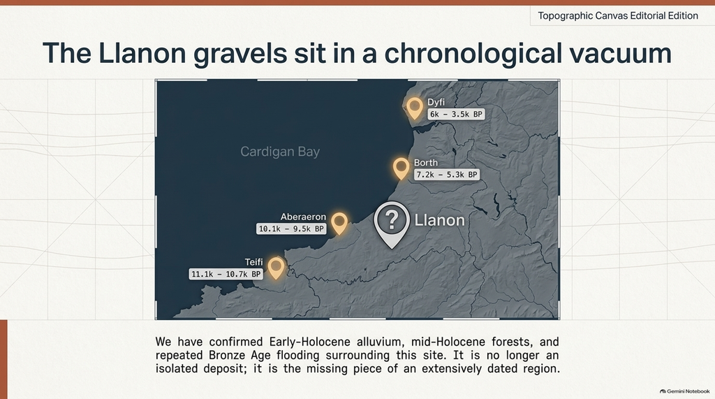
In the sources I have examined, I can find no direct radiocarbon or OSL chronology through the Llanon alluvial gravel sequence itself.
That distinction now becomes critical.
Because the surrounding landscape does have dates.
LiDAR Shows Why the Old View Is Too Small
Standing beneath a four-metre cliff, the human eye naturally concentrates upon the section directly in front of it.
Modern LiDAR changes that completely.
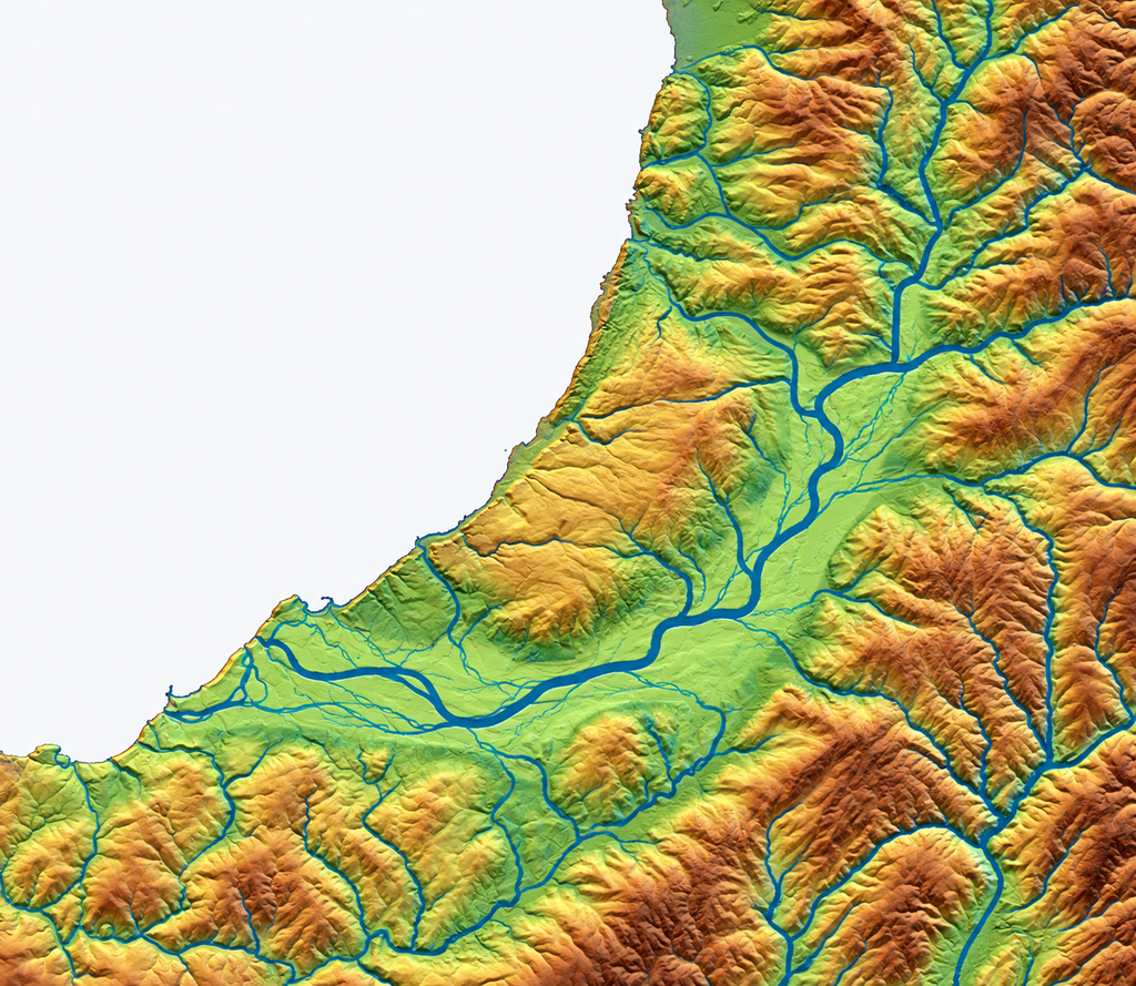
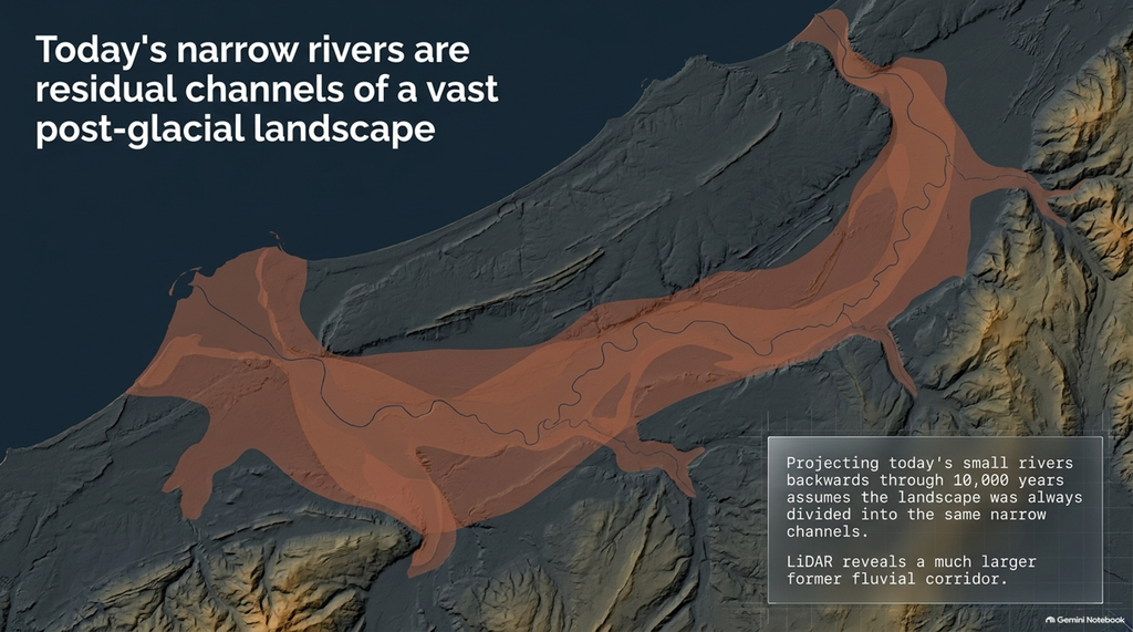
Viewed from above, the Cardigan Bay landscape shows Llanon no longer as an isolated deposit associated with a tiny modern stream.
It sits at the western edge of an enormous low-relief drainage landscape.
Numerous valleys descend from the higher ground.
Tributaries converge.
Drainage lines divide.
Broad, smooth lowlands extend towards the present coast.
The modern named rivers occupy only narrow portions of this much larger landscape.
That distinction matters.
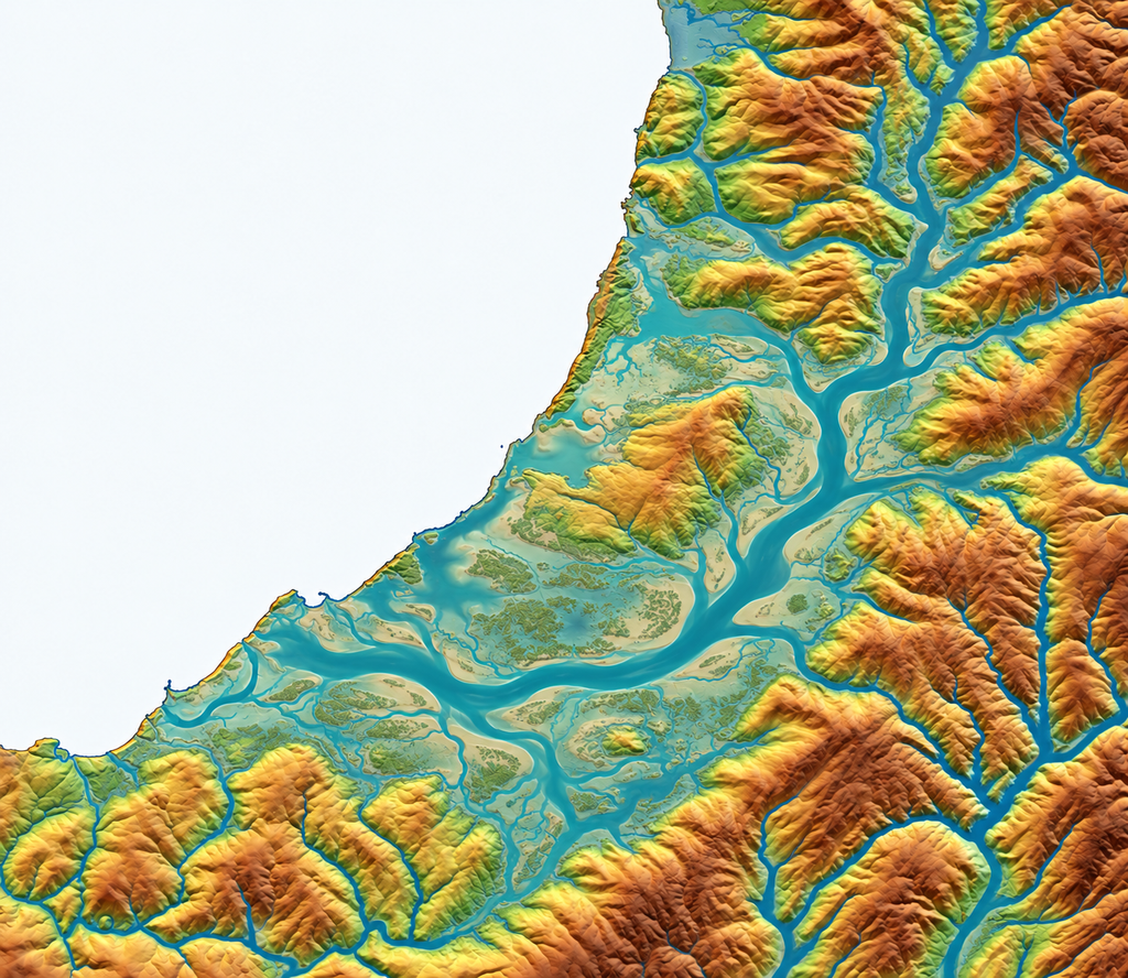
It is dangerous to project today’s small rivers backwards through ten thousand years and assume that the landscape was always divided into exactly the same narrow channels.
The PGFH instead predicts that during the long post-glacial adjustment, these lowlands could have contained much broader floodplains, wetlands, migrating channels, anabranching systems and saturated ground.
As discharge and hydraulic head fell, those larger systems would progressively contract towards the rivers visible today.
That is exactly the kind of landscape the LiDAR allows us to investigate.
PGFH Did Not Begin at Llanon
This is important.
The Post-Glacial Flooding Hypothesis was not invented to explain these photographs.
The quantitative argument already existed.
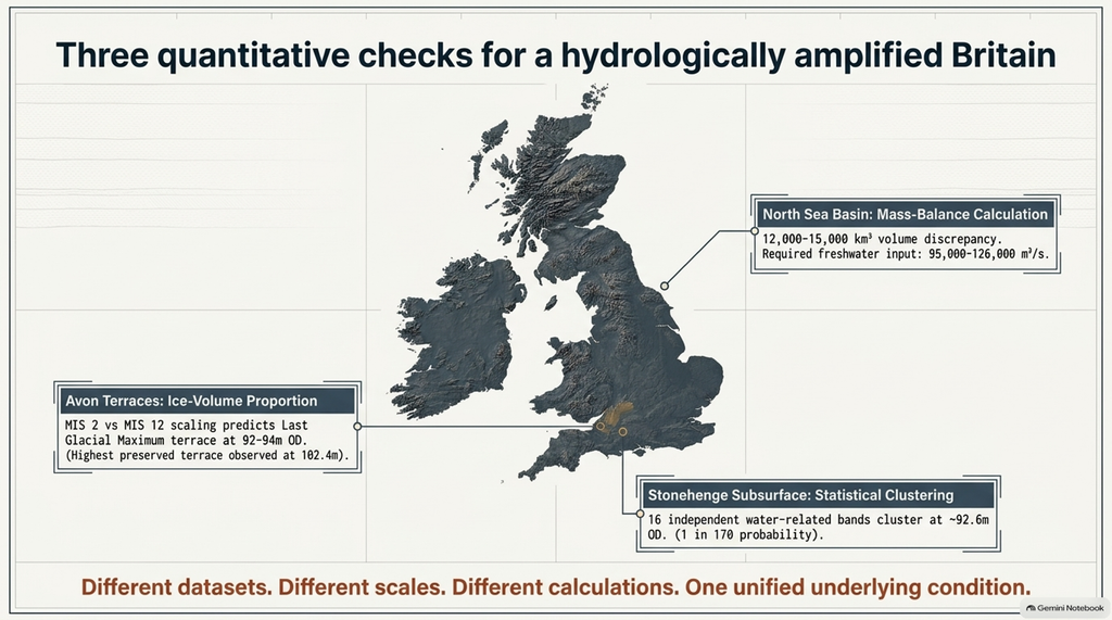
In the latest PGFH work, the North Sea basin is treated as a mass-balance problem.
Using the adopted sea-level curves and changing basin geometry, the calculation produces an observed early-to-mid-Holocene basin infill of approximately 20,000 to 24,000 cubic kilometres, compared with an expected 7,000 to 9,000 cubic kilometres under the stabilisation model used in the calculation.
That leaves a calculated discrepancy of approximately 12,000 to 15,000 cubic kilometres.
Converted over approximately five thousand years, the PGFH calculation expresses the required additional freshwater input as roughly 95,000 to 126,000 cubic metres per second.
That is the first quantitative constraint in the book.
The second examines the Avon terrace staircase.
Published ice-volume estimates place MIS 2, the Last Glacial Maximum, at roughly 91 to 92 per cent of the ice volume associated with MIS 12.
The PGFH scaling calculation therefore predicts an LGM terrace around 92 to 94 metres OD when the highest preserved terrace is approximately 102.4 metres.
That predicted band corresponds closely to the published T9 elevation range.
The third quantitative test uses Stonehenge borehole data.
Rather than comparing raw depths, water-related materials are normalised to common Ordnance Datum elevations.
Shells, gravels, cobbles, sand, silt, marl, organic staining and solution features repeatedly converge in shared elevation zones.
Within the selected envelope around 92.6 metres OD, the book calculates the chance of sixteen independent water-related bands clustering there under its null model at approximately one in 170.
Different datasets.
Different geographical scales.
Different calculations.
Yet all three are used by PGFH to argue for the same underlying condition:
Britain remained hydrologically amplified for thousands of years after the Ice Age.
Cardigan Bay can therefore serve as an independent geographical check against an existing prediction.
And Cardigan Bay Has Real Holocene Dates
This is where the evidence becomes particularly powerful.
Although the Llanon gravel sequence itself apparently lacks a direct numerical chronology, neighbouring Cardigan Bay landscapes most certainly do not.
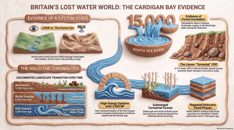
The British Geological Survey classifies the Teifi Valley Formation as Holocene.
It consists of stratified gravel, sand, silt, and clay that form the alluvial deposits of the Teifi and its tributaries.
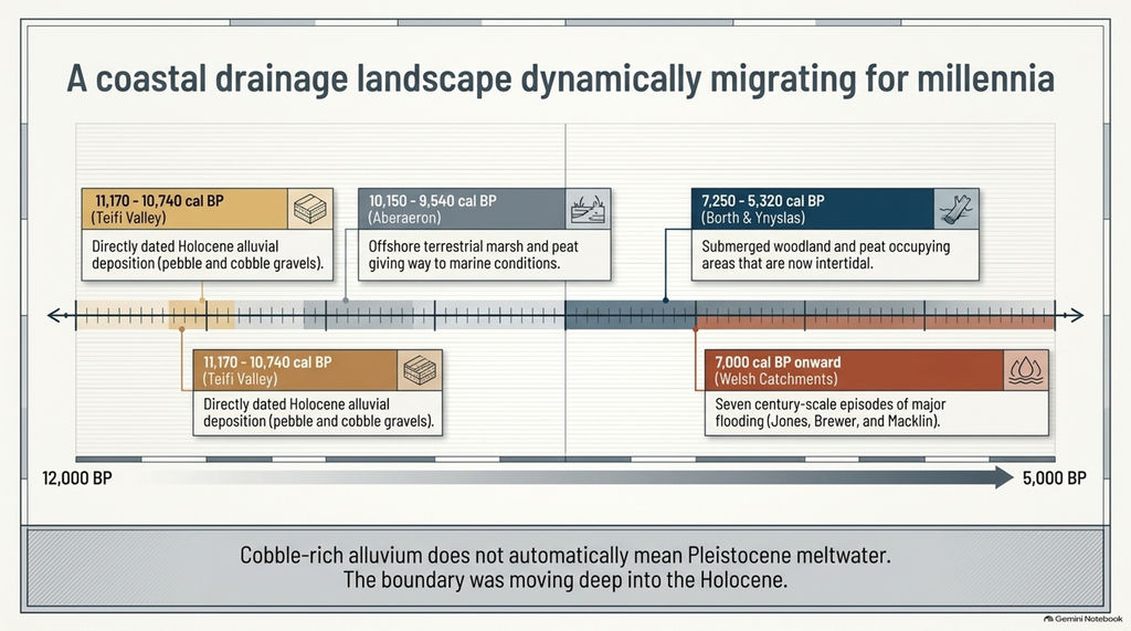
Crucially, BGS states that the major alluvial fans and terraces can contain pebble and cobble gravels, and that portions of the sequence have been radiocarbon dated to approximately 11,170 to 10,740 calibrated years before present.
That immediately removes one simplistic assumption.
Cobble-rich alluvium does not automatically mean Pleistocene meltwater.
We have directly dated Holocene alluvial deposition within a major drainage system flowing into Cardigan Bay.
And the evidence continues.
Jones, Brewer and Macklin used valley-floor geomorphology, sedimentology and radiocarbon dating at Welsh sites in the Severn, Teifi and Dee catchments.
Their peer-reviewed study identifies seven probable century-scale episodes of major flooding since approximately 7,000 cal BP, with Welsh flood phases occurring at similar times to peaks in flood frequency across Britain.
These are not hypothetical floods reconstructed from the PGFH.
They are independently published palaeoflood evidence.
Cardigan Bay Already Has a Holocene Coastal Timeline
The coastline itself also supplies numerical evidence.
At Aberaeron, peat from an offshore core gave a radiocarbon measurement of 8,740 plus or minus 110 radiocarbon years BP, calibrated in the research poster to approximately 9,540 to 10,150 cal BP.
The sequence records terrestrial marsh conditions giving way to estuarine mud and eventually fully marine conditions.
Farther north at Borth and Ynyslas, the submerged forest provides another directly dated Holocene terrestrial landscape.
The peat dates to approximately 6,400 to 7,150 cal BP, while the birch wood dates to approximately 6,560 to 7,250 cal BP.
Other Borth material has been reported as young as approximately 5,320 to 5,580 cal BP.
So Cardigan Bay does not give us one isolated Holocene date.
It provides a sequence.
Around ten thousand years ago, terrestrial peat existed around Aberaeron.
Thousands of years later, woodland and peat still occupied areas around Borth and Ynyslas that are now intertidal.
The research poster concludes that submerged forests existed at different Welsh coastal locations for at least two thousand years during the mid-Holocene, on surfaces now exposed only at low tide.
The landscape was still changing.
The shoreline was still moving.
The drainage boundary was still moving.
The rivers entering Cardigan Bay were therefore not operating against today’s coastline.
Then Comes the Dyfi Evidence
And this may be the most important independent comparison of all.
A peer-reviewed study by Zhong Shi and H. F. Lamb reconstructed the post-glacial sedimentary evolution of the Dyfi Estuary on Cardigan Bay using extensive cores, sedimentary characteristics and chronostratigraphic cross-sections.
Their reconstruction does not describe a short meltwater event followed by a modern-type landscape.
It describes a prolonged sequence.
From approximately 15,000 to 10,000 years BP, the Dyfi was a shallow-water, high-energy fluvially dominated system.
From approximately 10,000 to 6,000 BP, it became a deeper, lower-energy estuarine environment.
Then, between approximately 6,000 and 3,500 BP, high-energy conditions returned in a shallow-water, tidally dominated system.
Only after approximately 3,500 BP does their sequence enter the shallow-water, lower-energy estuarine and salt-marsh phase approaching the later landscape.
Think about what that actually means.
The hydrological transformation of this part of Cardigan Bay continued until approximately the Bronze Age.
Not because PGFH says so.
Because a peer-reviewed sedimentary study says so.
This does not independently prove every proposed PGFH mechanism.
But the duration and scale are exactly the kind of prolonged post-glacial adjustment that PGFH predicts.
And that is a very different position from where this investigation started.
This Is Not One Meltwater Flood
That point needs emphasising.
Cardigan Bay was not transformed by one giant event and then left to settle quietly into its modern configuration.
The evidence records thousands of years of changing conditions.
High-energy rivers.
Terrestrial marsh.
Peat.
Woodland.
Marine transgression.
Estuarine sedimentation.
Major Welsh flood episodes.
Renewed high-energy tidal conditions.
And finally, the later lower-energy coastal system.
The conventional literature uses several mechanisms to explain those individual observations: eustatic sea-level rise, glacial isostatic adjustment, changing tidal range, sedimentation, climate variability and local geomorphology.
PGFH does not need to pretend those processes did not exist.
Its challenge is different.
Why should they remain unrelated chapters when they form one continuous hydrological transition?
That is the larger pattern PGFH was designed to explain.
The Timeline Now Matches the PGFH Prediction Remarkably Well
The later PGFH model describes a prolonged period during which river systems, aquifers and changing coastal base levels continued re-equilibrating after the principal glacial melt.
In the book’s wider comparative framework, 6,000 to 3,000 BP is identified as a period of continuing hydraulic relaxation, with rivers and aquifers still draining after the main eustatic forcing had diminished.
Now compare that with Shi and Lamb.
Their independent Cardigan Bay reconstruction identifies a 6,000 to 3,500 BP high-energy phase in the Dyfi.
That does not mean the two studies use the same mechanism.
They do not.
But the chronological correspondence is impossible to ignore.
PGFH predicts prolonged hydrological adjustment extending deep into the Holocene.
The independent Dyfi sedimentary record documents energetic environmental adjustment extending deep into the Holocene.
This corroborates the predicted timescale, even though the causal interpretation remains different.
So What About the Llanon Cliff?
This brings us back to the cliff that began this investigation.
At Llanon we have approximately four metres of predominantly alluvial deposits.
Published geologists describe part of the sequence as torrential alluvial boulder gravels.
They recognise a large fan.
They recognise east-to-west water transport.
They recognise a multi-phase sedimentary history.
But the chronology of the gravel sequence itself still appears to rest primarily on stratigraphic interpretation rather than a modern series of numerical dates.
That position now looks increasingly unsatisfactory.
Because around it we have:
directly dated Early-Holocene alluvium in the Teifi;
repeated radiocarbon-dated Holocene flooding in Welsh catchments;
Early-Holocene terrestrial peat offshore at Aberaeron;
mid-Holocene forests and peat at Borth and Ynyslas;
and a peer-reviewed Dyfi record showing major hydrological and sedimentary change extending to approximately 3,500 BP.
The Llanon gravels therefore no longer sit in a chronological vacuum.
They sit inside a region whose Holocene hydrological history is increasingly well dated.
The outstanding issue is precisely where within that regional history the individual Llanon units belong.
The Modern Rivers Are the End of the Story, Not the Beginning
This is also why the LiDAR is so revealing.
The modern Peris, Clydan, Aeron, Teifi and Dyfi are the end result of thousands of years of drainage adjustment.
They should not automatically be treated as the template for reconstructing the beginning of that process.
During earlier phases, broad areas visible today as lowlands may have contained migrating channels, wetlands, interconnected flood basins and much wider fluvial corridors.
And today’s coastline cannot be used as the western boundary.
We know terrestrial ground extended into what is now Cardigan Bay.
The modern rivers are therefore residual channels within a much larger former landscape.
That is precisely the perspective that ground-level stratigraphy alone can miss.
And Then There Is the South Coast
This is where the Cardigan Bay evidence stops being merely a Welsh story.
My earlier work on the South Downs identified substantial superficial deposits that fill valleys and cut into the chalk landscape.
Sand, silt, clay, gravel and disturbed chalk lie remarkably close to the modern surface in places.
My earlier interpretation was that these features preserve a much larger former hydrological landscape than today’s dry valleys suggest.
Cardigan Bay gives us something the South Downs investigation badly needed:
an independently dated example of a major British post-glacial landscape continuing to reorganise for thousands of years.
The geology is different.
The depositional environments are different.
But PGFH does not predict identical sediments everywhere.
It predicts the same hydrological transition, expressed differently according to local geology, elevation, and drainage.
Cardigan Bay.
The South Downs.
The Avon terraces.
The North Sea basin.
Stonehenge’s subsurface hydrology.
PGFH argues that these should not automatically be separated into unrelated geological curiosities.
They should be tested as parts of the same post-glacial hydraulic adjustment.
From Local Observation to a Much Larger Model
This is also where the word “hypothesis” can become misleading.
The PGFH began as a hypothesis.
But the latest work no longer rests simply upon visual similarities between drowned landscapes.
It contains quantitative claims that can be checked.
A North Sea mass-balance calculation.
A terrace-elevation prediction derived from global ice-volume proportions.
An OD-normalised statistical test of water-related deposits beneath Stonehenge.
And now those calculations can be compared against independent regional datasets.
Cardigan Bay provides one such comparison.
The independent literature does not say “PGFH is correct.”
It was not written to test PGFH.
That is precisely what makes the correspondence valuable.
The researchers independently document the prolonged Holocene conditions that the model predicts.
What the Evidence Now Says
We can therefore make a much firmer statement than before.
The question is no longer whether Britain’s hydrological landscape changed dramatically after the Ice Age.
It did.
The question is no longer whether significant Welsh flooding continued into the Holocene.
It did.
The question is no longer whether Cardigan Bay contained terrestrial landscapes long after deglaciation.
It did.
The question is no longer whether major sedimentary and hydrological adjustment continued for thousands of years.
The Dyfi record demonstrates that it did.
And at Llanon, the question is no longer whether powerful water deposited the gravels.
Published geology already says that it did.
What remains unresolved is narrower:
How much of the Llanon alluvial sequence belongs within this now-established Holocene history?
That can be settled.
Date it.
Radiocarbon-suitable organic horizons.
Use OSL where appropriate on the sand units.
Sample the upper alluvium immediately beneath the modern soil.
Then repeat through the section.
Top.
Middle.
Bottom.
The regional chronology is already waiting for the result.
The Bigger Picture
Cardigan Bay may therefore be doing something far more important than providing another example of prehistoric flooding.
It is beginning to connect the scales.
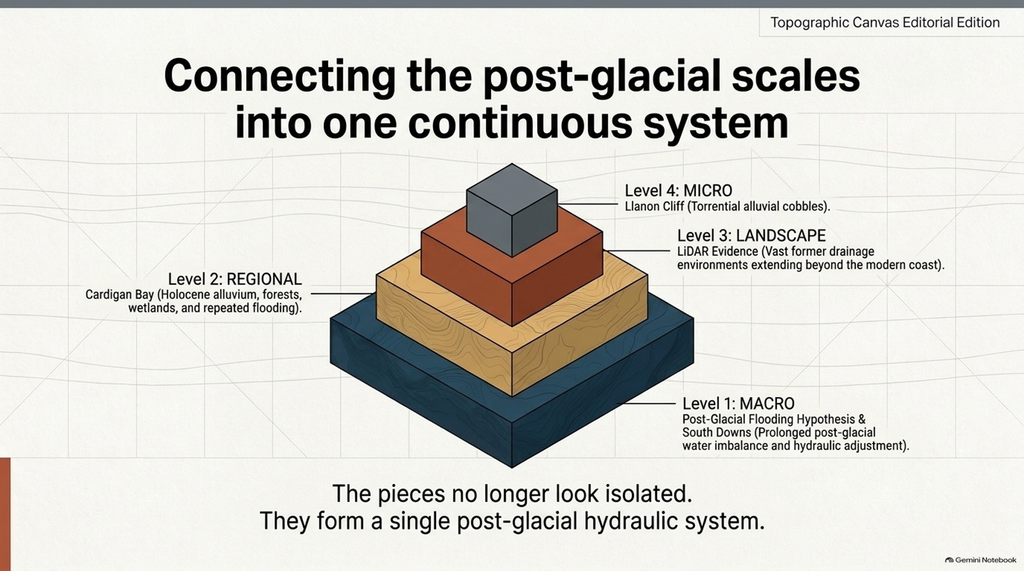
At the smallest scale, we have individual cobbles and sediment layers.
At landscape scale, LiDAR reveals a vast former drainage environment.
At regional scale, radiocarbon dates demonstrate Holocene alluvium, forests, wetlands and repeated flooding.
At basin scale, PGFH identifies a prolonged post-glacial water imbalance.
And at the national scale, similar questions appear in the dry valleys and superficial deposits of southern Britain.
The pieces no longer look isolated.
They begin to form a system.
Cardigan Bay Is No Longer Just a Possibility
When I first photographed the Llanon cliff, the question was:
Could this support the Post-Glacial Flooding Hypothesis?
After examining the published geological description, the radiocarbon chronology, the Welsh palaeoflood record, the Borth forests, the Aberaeron peat, the Teifi alluvium and the peer-reviewed Dyfi sedimentary sequence, I think the question has changed.
The independent evidence now demonstrates many of the conditions that PGFH predicted should exist:
A much larger former fluvial landscape.
Substantial Holocene alluviation.
Repeated Holocene flooding.
Terrestrial surfaces now beneath the sea.
A coastline still migrating for millennia.
Energetic hydrological conditions persisted until approximately the Bronze Age.
The Cardigan Bay evidence does not create the PGFH.
It independently falls into the pattern the PGFH had already predicted.
And that is a much more important result.
The LiDAR gives us the landscape.
The radiocarbon dates give us the chronology.
The peer-reviewed sedimentary work gives us the duration.
The PGFH provides a single hydrological framework in which those apparently separate observations can be compared.
And now one particularly important piece remains.
Date the Llanon cliff.
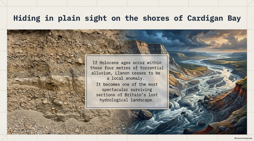
Because if Holocene ages occur within those four metres of torrential alluvium, then one of the most spectacular surviving sections of Britain’s post-glacial hydrological landscape may already be sitting in full view on the shores of Cardigan Bay.
Go Beyond the Free Article
Explore the evidence behind our investigations with Prehistoric Britain membership from just 99p per month – starting in 2027.
Access extensive searchable maps, videos, podcasts, research material and references to the underlying data — allowing you to examine the evidence for yourself.
Become a member and explore Britain’s prehistoric landscape in far greater detail.
PODCAST

Author’s Biography

Robert John Langdon, a polymathic luminary, emerges as a writer, historian, and eminent specialist in LiDAR Landscape Archaeology.
His intellectual voyage has been interwoven with stints as an astute scrutineer in government and major corporate bastions, spanning British Telecommunications, Cable and Wireless, British Gas, and the esteemed University of London.
A decade hence, Robert’s transition into retirement unfurled a chapter of insatiable curiosity. He immersed himself in Politics, Archaeology, Philosophy, and the enigmatic realm of Quantum Mechanics. His academic odyssey took him through the venerable corridors of knowledge hubs such as the Museum of London, University College London, Birkbeck College, The City Literature Institute, and Chichester University.
In the symphony of his life, Robert is a custodian of three progeny and a pair of cherished grandchildren. His sanctuary lies ensconced in the embrace of West Wales, where he inhabits an isolated cottage, its windows framing a vista of the boundless sea – a retreat from the scrutinising gaze of Her Majesty’s Revenue and Customs, an amiable clandestinity in the lap of nature.
Exploring Prehistoric Britain: A Journey Through Time
My blog delves into the fascinating mysteries of prehistoric Britain, challenging conventional narratives and offering fresh perspectives grounded in cutting-edge research, particularly LiDAR technology. I invite you to explore some key areas of my research. For example, I re-examine the Wansdyke, often cited as a defensive structure, in light of new evidence. I’ve presented my findings in my blog post Wansdyke: A British Frontier Wall – ‘Debunked’, and a Wansdyke LiDAR Flyover video further visualises my conclusions.
My work also often challenges established archaeological dogma. I argue that many sites, such as Hambledon Hill, commonly identified as Iron Age hillforts, are not what they seem. My posts Lidar Investigation Hambledon Hill – NOT an ‘Iron Age Fort’ and Unmasking the “Iron Age Hillfort” Myth explore these ideas in detail and offer an alternative view. Similarly, I re-evaluated sites like Cissbury Ring and White Sheet Camp through LiDAR analysis in my posts “Lidar Investigation Cissbury Ring through time” and “Lidar Investigation White Sheet Camp,“ revealing fascinating insights into their true purpose. I have also examined South Cadbury Castle, often linked to the mythical Camelot56.
My research also extends to ancient water management, including the role of canals and other linear earthworks. I have discussed the true origins of Car Dyke in multiple posts, including Car Dyke – ABC News Podcast and Lidar Investigation Car Dyke – North Section, which suggest a Mesolithic origin 2357. I also explore the misidentification of Roman aqueducts, as seen in my posts on the Great Chesters (Roman) Aqueduct. My research has also been greatly informed by my post-glacial flooding hypothesis, which has helped explain landscape transformations over time. I have discussed this hypothesis in several posts, including AI now supports my Post-Glacial Flooding Hypothesis and Exploring Britain’s Flooded Past: A Personal Journey
Finally, my blog also investigates prehistoric burial practices, as seen in Prehistoric Burial Practices of Britain and explores the mystery of Pillow Mounds, often mistaken for medieval rabbit warrens, but with a potential link to Bronze Age cremation in my posts: Pillow Mounds: A Bronze Age Legacy of Cremation? and The Mystery of Pillow Mounds: Are They Really Medieval Rabbit Warrens?. My research also includes astronomical insights into ancient sites, for example, in Rediscovering the Winter Solstice: The Original Winter Festival. I also review new information about the construction of Stonehenge in The Stonehenge Enigma.
Yes. I’d make this far tighter, more inviting and more obviously a gateway into the rest of your work. The present version repeats the website several times and reads more like an author biography than a “what next?” section.
I’d also make the three routes immediately obvious: Explore the Research → Watch the Videos → Read the Books, with Facebook as the discussion/community route.
Further Reading — Explore the Evidence
The investigation doesn’t end with this article.
Prehistoric Britain brings together hundreds of articles, LiDAR investigations, field discoveries, archaeological studies and original research exploring Britain’s prehistoric landscape from a different perspective.
Follow the evidence across ancient waterways, lost landscapes, Stonehenge and Avebury, prehistoric engineering, submerged Britain, ancient DNA and the effects of post-glacial flooding — comparing established archaeological interpretations with alternative explanations suggested by the physical evidence.
🎬 Watch the Investigations
Prefer to watch rather than read?
The Robert John Langdon YouTube channel has more than 200 documentaries, investigations, and video presentations that bring the research to life through maps, LiDAR, archaeological evidence, and landscape reconstruction.
Discover investigations including 13 Things That Don’t Make Sense in History, Silbury Avenue – The Lost Stone Avenue, Stonehenge, prehistoric waterways, submerged landscapes and many more.
📚 Explore the Book Library
Go deeper into the evidence through Robert John Langdon’s growing collection of books and specialist studies, including:
- The Stonehenge Hoax – 13 Things That Don’t Make Sense in History
- Car Dyke – Prehistoric Dyke
- Wansdyke – Prehistoric Dyke
- Offa’s Dyke – Prehistoric Dyke
- Silbury Avenue – The Lost Stone Avenue
- The Vallum – At Hadrian’s Wall
- Stonehenge: The World’s First Computer
- Avebury’s Lost Stone Avenue
Many of these investigations connect directly with the evidence discussed throughout the website, allowing individual discoveries to be examined as part of the much wider prehistoric landscape.
🔎 Read the Main Trilogy
Three major works bring together the central strands of the research:
The Post-Glacial Flooding Hypothesis — investigates the evidence for radically different water levels, waterways and landscapes in prehistoric Britain.
The Stonehenge Enigma — re-examines the chronology, landscape and purpose of one of the world’s most famous prehistoric monuments.
Dawn of the Lost Civilisation — explores the evidence for sophisticated communities, technology and maritime connections far earlier than traditionally assumed.
💬 Join the Investigation
New discoveries, LiDAR surveys and research are discussed as they happen in the Prehistoric Britain Facebook Group.
Join the discussion, challenge the evidence, offer alternative interpretations and follow new investigations as they develop.
Don’t just read the accepted story. Explore the evidence, compare the interpretations, and decide for yourself.
Other Blogs
1
a
- AI now Supports – Homo Superior
- AI now supports my Post-Glacial Flooding Hypothesis
- Alexander the Great sailed into India – where no rivers exist today
- Ancient Secrets of Althorp – debunked
- Antler Picks built Ancient Monuments – yet there is no real evidence
- Antonine Wall – Prehistoric Canals (Dykes)
- Archaeological ‘pulp fiction’ – has archaeology turned from science?
- Archaeological Pseudoscience
- Archaeology in the Post-Truth Era
- Archaeology: A Bad Science?
- Archaeology: A Harbour for Fantasists?
- Archaeology: Fact or Fiction?
- Archaeology: The Flaws of Peer Review
- Archaeology’s Bayesian Mistake: Stop Averaging the Past
- Are Raised Beaches Archaeological Pseudoscience?
- Atlantis Found: The Mathematical Proof That Plato’s Lost City Was Doggerland
- ATLANTIS: Discovery with Dan Snow Debunked
- Avebury Ditch – Avebury Phase 2
- Avebury through time
- Avebury’s great mystery revealed
- Avebury’s Lost Stone Avenue – Flipbook
b
- Battlesbury Hill – Wiltshire
- Beyond Stone and Bone: Rethinking the Megalithic Architects of Northern Europe
- BGS Prehistoric River Map
- Blackhenge: Debunking the Media misinterpretation of the Stonehenge Builders
- Brain capacity (Cro-Magnon Man)
- Britain’s First Road – Stonehenge Avenue
- Britain’s Giant Prehistoric Waterways
- British Roman Ports miles away from the coast
c
- Caerfai Promontory Fort – Archaeological Nonsense
- Car Dyke – ABC News PodCast
- Car Dyke – North Section
- Cardigan Bay: The Holocene Evidence the Old Geological Story Has Missed
- CASE STUDY – An Inconvenient TRUTH (Craig Rhos Y Felin)
- Case Study – River Avon
- Case Study – Woodhenge Reconstruction
- Chapter 2 – Craig Rhos-Y-Felin Debunked
- Chapter 2 – Stonehenge Phase I
- Chapter 2 – Variation of the Species
- Chapter 3 – Post Glacial Sea Levels
- Chapter 3 – Stonehenge Phase II
- Chapter 7 – Britain’s Post-Glacial Flooding
- Cissbury Ring through time
- Clement Reid, Doggerland, and the Archaeological Establishment
- Cro-Magnon Brain Capacity
- Cro-Magnon Megalithic Builders: Measurement, Biology, and the DNA
- Cro-Magnons – An Explainer
d
- Darwin’s Children – Flipbook
- Darwin’s Children – The Cro-Magnons
- Dawn of The Lost Civilisation – 1/10
- Dawn of the Lost Civilisation – Flipbook
- Dawn of the Lost Civilisation – Introduction
- Digging for Britain – Cerne Abbas
- Digging for Britain Debunked – Cerne Abbas 2
- Digging Up Britain’s Past – Debunked
- DLC Chapter 1 – The Ascent of Man
- Durrington Walls – Woodhenge through time
- Durrington Walls Revisited: Platforms, Fish Traps, and a Managed Mesolithic Landscape
- Dyke Construction – Hydrology 101
- Dykes Ditches and Earthworks
- DYKES of Britain
e
f
g
h
- Hadrian’s Wall – Military Way Hoax
- Hadrian’s Wall – the Stanegate Hoax
- Hadrian’s Wall Vallum – Prehistoric Canals – FREE Online Book
- Hadrian’s Wall LiDAR investigation
- Hambledon Hill – NOT an ‘Iron Age Fort’
- Hayling Island Lidar Maps
- Hidden Sources of Ancient Dykes: Tracing Underground Groundwater Fractals
- Historic River Avon
- Hollingsbury Camp Brighton – A Hillfort… or a Forgotten Harbour?
- Hollows, Sunken Lanes and Palaeochannels
- Homo Superior – Flipbook
- Homo Superior – History’s Giants
- How Lidar will change Archaeology
- Hydrology 101 Simplified: Why Britain’s Dykes Worked Without Rivers
i
l
m
- Maiden Castle through time
- Mathematics Meets Archaeology: Discovering the Mesolithic Origins of Car Dyke
- Mesolithic River Avon
- Mesolithic Stonehenge
- Minerals found in Prehistoric and Roman Quarries
- Mining in the Prehistoric to Roman Period
- Mount Caburn through time
- Mysteries of the Oldest Boatyard Uncovered
- Mythological Dragons – a non-existent animal that is shared by the World.
o
- Offa’s Dyke Flipbook
- Old Sarum Lidar Map
- Old Sarum Through Time…………….
- On Sunken Lands of the North Sea – Lived the World’s Greatest Civilisation.
- OSL Chronicles: Questioning Time in the Geological Tale of the Avon Valley
- Oswestry LiDAR Survey
- Oswestry through time
- Oysters in Archaeology: Nature’s Ancient Water Filters?
p
- Pillow Mounds: A Bronze Age Legacy of Cremation?
- Pinkery Canal
- Plato Was Right: The Archaeological Evidence the Academics Never Expected
- Post Glacial Flooding – Flipbook
- Prehistoric Burial Practices of Britain
- Prehistoric Canals – Wansdyke
- Prehistoric Canals – Wansdyke
- Prehistoric Canals (Dykes) – Great Chesters Aqueduct (The Vallum Pt. 4)
- Prehistoric Canals (Dykes) – Offa’s Dyke (Chepstow)
- Prehistoric Canals (Dykes) – Offa’s Dyke (LiDAR Survey)
- Prehistoric Canals (Dykes) – Offa’s Dyke Survey (End of Section A)
- Prehistoric Canals (Dykes) – Wansdyke (4)
- Prehistoric Canals Wansdyke 2
- Professor Bonkers and the mad, mad World of Archaeology
r
- Real-World Confirmation of Post-Glacial Flooding
- Rebirth in Stone: Decrypting the Winter Solstice Legacy of Stonehenge
- Rediscovering the Winter Solstice: The Original Winter Festival
- Rethinking Ancient Boundaries: The Vallum and Offa’s Dyke”
- Rethinking Ogham: Could Ireland’s Oldest Script Have Begun as a Tally System?
- Rethinking The Past: Mathematical Proof of Langdon’s Post-Glacial Flooding Hypothesis
- Revolutionising History: Car Dyke Unveiled as Prehistoric & the Launch of FusionBook 360
- Rising Evidence, Falling Rivers: The Real Story of Europe’s First Farmers
- Rivers of the Past Were Higher: A Fresh Perspective on Prehistoric Hydrology
s
- Sea Level Changes
- Section A – NY26SW
- Section B – NY25NE & NY26SE
- Section C – NY35NW
- Section D – NY35NE
- Section E – NY46SW & NY45NW
- Section F – NY46SE & NY45NE
- Section G – NY56SW
- Section H – NY56NE & NY56SE
- Section I – NY66NW
- Section J – NY66NE
- Section K – NY76NW
- Section L – NY76NE
- Section M – NY87SW & NY86NW
- Section N – NY87SE
- Section O – NY97SW & NY96NW
- Section P – NY96NE
- Section Q – NZ06NW
- Section R – NZ06NE
- Section S – NZ16NW
- Section T – NZ16NE
- Section U – NZ26NW & NZ26SW
- Section V – NZ26NE & NZ26SE
- Silbury Avenue – Avebury’s First Stone Avenue
- Silbury Hill
- Silbury Hill / Sanctuary – Avebury Phase 3
- Sky Maps of Prehistoric Britain
- Somerset Plain – Signs of Post-Glacial Flooding
- South Cadbury Castle – Camelot
- Statonbury Camp near Bath – an example of West Wansdyke
- Stone me – the druids are looking the wrong way on Solstice day
- Stone Transportation and Dumb Censorship
- Stonehenge – Monument to the Dead
- Stonehenge Hoax – Dating the Monument
- Stonehenge Hoax – Round Monument?
- Stonehenge Hoax – Summer Solstice
- Stonehenge LiDAR tour
- Stonehenge Phase 1 — Britain’s First Monument
- Stonehenge Phase I (The Stonehenge Landscape)
- Stonehenge Solved – Pythagorean maths put to use 4,000 years before he was born
- Stonehenge Through Time
- Stonehenge, Doggerland and Atlantis connection
- Stonehenge: Borehole Evidence of Post-Glacial Flooding
- Stonehenge: Discovery with Dan Snow Debunked
- Stonehenge: The World’s First Computer – FREE Book
- Stonehenge: The Worlds First Computer
- Stonehenge’s The Lost Circle Revealed – DEBUNKED
- Stonehenge’s Chronological Mirage
t
- Ten Reasons Why Car Dyke Blows Britain’s Earthwork Myths Out of the Water
- Ten Things You Didn’t Know About Britain’s Prehistoric Flooded Past
- Ten thousand year old boats found on Northern Europe’s Hillsides
- Ten thousand-year-old boats found on Northern Europe’s Hillsides
- Testing Plato’s Atlantis Against Reality
- The “Hunter-Gatherer” Myth: Why It’s Time to Bury This Outdated Term
- The Ancient Mariners – Flipbook
- The Ancient Mariners – Prehistoric seafarers of the Mesolithic
- The Ascent of Man — From Survival to Systems
- The Beringian Migration Myth: Why the Peopling of the Americas by Foot is Mathematically and Logistically Impossible
- The Bluestone Enigma
- The Bulford Hoax: The “Simpler, Older Stonehenge” That Wasn’t
- The Cheddar Man Hoax
- The Cro-Magnon Cover-Up: How DNA and PR Labels Erased Our Real Ancestry
- The Dolmen and Long Barrow Connection
- The Durrington Mega-Monument Hoax: What Lies Beneath? – Debunked
- The Durrington Walls Hoax – it’s not a henge?
- The Dyke Myth Collapses: Excavation and Dating Prove Britain’s Great Dykes Are Prehistoric Canals
- The First European Smelted Bronzes
- The Fury of the Past: Natural Disasters in Historical and Prehistoric Britain
- The Giant’s Graves of Cumbria
- The Giants of Prehistory: Cro-Magnon and the Ancient Monuments
- The Great Ancient DNA Illusion: How Statistical Models Became Archaeological “Facts”
- The Great Antler Pick Hoax
- The Great Bell Beaker Migration Myth
- The Great Chichester Hoax – A Bridge too far?
- The Great Dorchester Aqueduct Hoax
- The Great Farming Hoax – (Einkorn Wheat)
- The Great Farming Migration Hoax
- The Great Hadrian’s Wall Hoax
- The Great Iron Age Hill Fort Hoax
- The Great Offa’s Dyke Hoax
- The Great Prehistoric Migration Hoax
- The Great Stone Transportation Hoax
- The Great Stonehenge Hoax
- The Great Wansdyke Hoax
- THE GREAT WEST WOODS HOAX — WHEN ONE STONE BECOMES FIFTY
- The Henge and River Relationship
- The Logistical Impossibility of Defending Maiden Castle
- The Long Barrow and Dolmen Enigma
- The Long Barrow Mystery
- The Long Barrow Mystery: Unravelling Ancient Connections
- The Lost Island of Avalon – revealed
- The Maiden Way Hoax – A Closer Look at an Ancient Road’s Hidden History
- The Maths – LGM total ice volume
- The Mystery of Pillow Mounds: Are They Really Medieval Rabbit Warrens?
- THE ODYSSEY PROBLEM: WHY DID A WEEK-LONG VOYAGE BECOME A TEN-YEAR EPIC?
- The Old Sarum Hoax
- The Oldest Boat Yard in the World found in Wales
- The Perils of Paradigm Shifts: Why Unconventional Hypotheses Get Branded as Pseudoscience
- The Post-Glacial Flooding Hypothesis – 1/11
- The Post-Glacial Flooding Hypothesis – Flipbook
- The Post-Glacial Flooding Theory
- The Problem with Hadrian’s Vallum
- The Rise of the Cro-Magnon (Homo Superior)
- The Roman Military Way Hoax
- The Silbury Hill Lighthouse?
- The Stone Money – Credit System
- The Stonehenge Avenue
- The Stonehenge Avenue
- The Stonehenge Code: Unveiling its 10,000-Year-Old Secret
- The Stonehenge Crescent: A Monument to a Lost World
- The Stonehenge Enigma – Flipbook
- The Stonehenge Enigma: Part 1/6
- The Stonehenge Hoax – Bluestone Quarry Site
- The Stonehenge Hoax – Flipbook
- The Stonehenge Hoax – Moving the Bluestones
- The Stonehenge Hoax – Periglacial Stripes
- The Stonehenge Hoax – Station Stones
- The Stonehenge Hoax – Stonehenge’s Location
- The Stonehenge Hoax – The Ditch
- The Stonehenge Hoax – The Slaughter Stone
- The Stonehenge Hoax – The Stonehenge Layer
- The Stonehenge Hoax – Totem Poles
- The Stonehenge Hoax – Woodhenge
- The Stonehenge Hospital
- The Stonehenge Transportation Mystery
- The Subtropical Britain Hoax
- The Troy, Hyperborea and Atlantis Connection
- The Vallum @ Hadrian’s Wall – it’s Prehistoric!
- The Vallum at Hadrian’s Wall (Summary)
- The Woodhenge Hoax
- Thirty Years of CAU Archaeology Going Nowhere?
- Three Dykes – Kidland Forest
- Thurnam’s 137 Skulls: The Forgotten People Behind Britain’s Megaliths.
- Top Ten Misidentified Fire Beacons in British History
- Troy Debunked – Troy did not exist in Asia Minor, but in fact, the North Sea island of Doggerland
- TSE – DVD Barrows
- TSE DVD – An Inconvenient Truth
- TSE DVD – Antler Picks
- TSE DVD – Avebury
- TSE DVD – Durrington Walls & Woodhenge
- TSE DVD – Dykes
- TSE DVD – Epilogue
- TSE DVD – Stonehenge Phase I
- TSE DVD – Stonehenge Phase II
- TSE DVD – The Post-Glacial Hypothesis
- TSE DVD Introduction
- TSE DVD Old Sarum
- Twigs, Charcoal, and the Death of the Saxon Dyke Myth
w
- Wansdyke – Short Film
- Wansdyke East – Prehistoric Canals
- Wansdyke Flipbook
- Wansdyke LiDAR Flyover
- Wansdyke: A British Frontier Wall – ‘Debunked’
- Was Columbus the first European to reach America?
- What Archaeology Missed Beneath Stonehenge
- White Sheet Camp
- Why a Simple Fence Beats a Massive Dyke (and What That Means for History)
- Windmill Hill – Avebury Phase 1
- Winter Solstice – Science, Propaganda and Indoctrination
- Woodhenge – the World’s First Lighthouse?