

Stonehenge: The World’s First Computer – FREE Book
Stonehenge: The World’s First Computer
Free online access to the complete evidence-based reconstruction of Stonehenge’s original function
This page provides free access to the full book
The Stonehenge Computer,
which presents a technical, testable model showing that Stonehenge was originally constructed as a functional astronomical and hydrological calculation device, not a ceremonial monument.
The model presented here treats Stonehenge as:
- a working system
- built to track lunar cycles
- linked directly to tides, groundwater, and seasonal prediction
- embedded in a post-glacial flooded landscape
🛒 Available Formats

What This Book Examines
Stonehenge has been described for centuries, but rarely analysed as a machine.
This book asks a simpler question:
What does Stonehenge actually do?
By examining geometry, spacing, repetition, and landscape position, the book demonstrates that the earliest phase of Stonehenge functions as a computational device capable of tracking:
- the 56-year lunar cycle
- nodal extremes of the Moon
- predictable tidal amplification
- seasonal water-table behaviour
These are not symbolic alignments.
They are operational relationships.
The Core Components of the Stonehenge Computer
1. The Aubrey Hole System
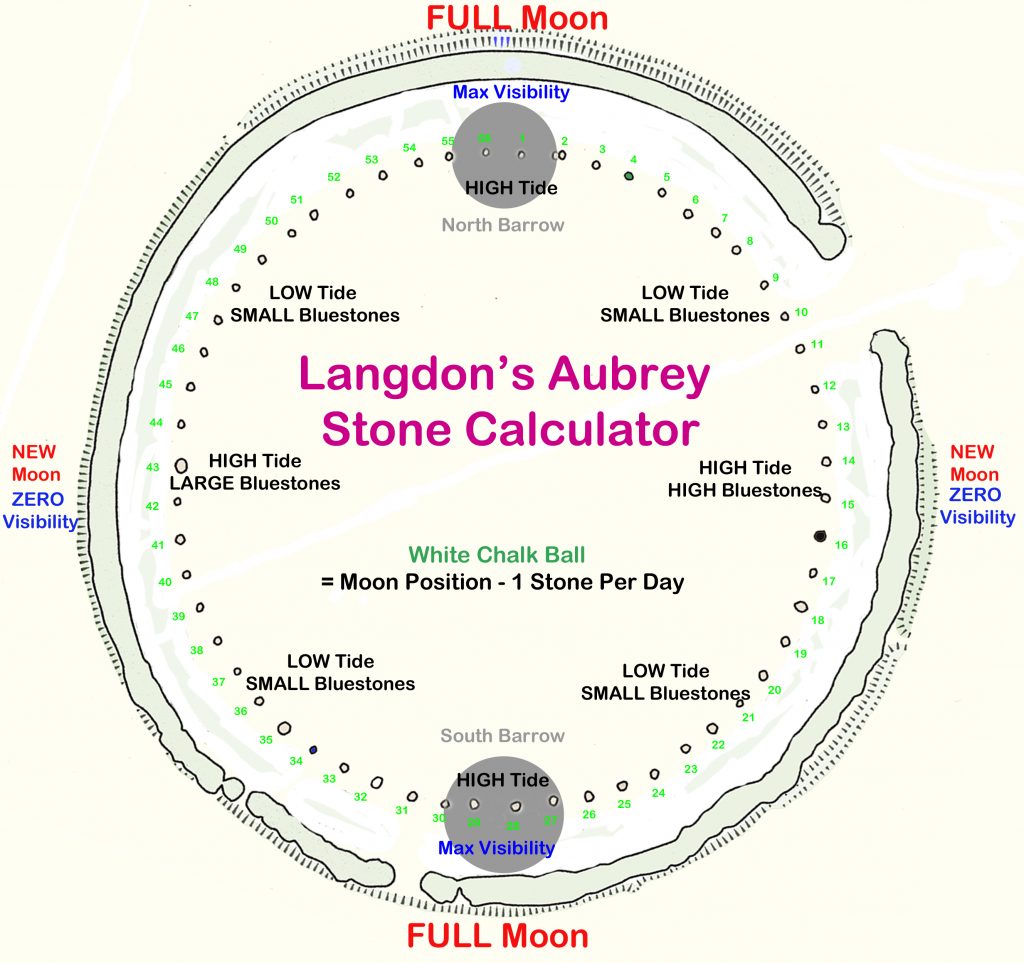
The 56 Aubrey Holes are treated not as burial pits, but as a cyclic counting array, consistent with known lunar periodicities.
Their number, spacing, and enclosure geometry allow:
- long-term tracking of the Moon
- correction for drift
- repeatable prediction over generations
2. The Ditch and Moat
The ditch is analysed as a deliberately water-holding structure, not a defensive feature.
Its construction method, internal form, and sediment sequence are consistent with:
- retained water
- controlled seepage
- interaction with the groundwater table
Water is not incidental — it is integral to function.
3. Bluestones as Active Elements
Rather than passive symbols, bluestones are examined as:
- interactive components
- mineral interfaces
- elements within a hydrological system
Their fragmentation and distribution are consistent with use, not decoration.
4. Astronomical Geometry
The geometry of the enclosure, entrances, and station points is shown to encode:
- solar extremes
- lunar standstills
- repeatable observational baselines
No single alignment explains Stonehenge.
The system does.
Why the “Computer” Interpretation Matters
Treating Stonehenge as a ritual monument creates contradictions:
- unnecessary complexity
- excessive precision
- redundant features
Treating it as a calculation device resolves them.
A society living in a water-dominated post-glacial landscape would need:
- tidal prediction
- seasonal forecasting
- long-term calendrical stability
Stonehenge provides exactly that.
Method and Constraints
This book deliberately avoids:
- mythological interpretation
- symbolic speculation
- retrofitted ritual narratives
Instead, it applies:
- measurable geometry
- repeatable cycles
- landscape hydrology
- empirical constraints
If a feature has no functional role, it is treated as unresolved — not explained away.
Relationship to the Wider Research
The Stonehenge Computer builds directly upon the hydrological framework established in:
- Post-Glacial Flooding in Britain
That earlier volume defines the environmental conditions under which Stonehenge was constructed.
This book shows how those conditions were:
- measured
- monitored
- and engineered into stone
Who This Book Is For
- Readers dissatisfied with ritual explanations
- Researchers interested in early science and engineering
- Archaeologists working with astronomical or landscape data
- Anyone asking how rather than why
This book forms part of a wider evidence-led sequence:
- Post-Glacial Flooding in Britain
- The Stonehenge Computer
- Dawn of the Lost Civilisation
All are available via the online bookcase.
Podcast

The Videos
More Book information
Contents
Foreword
Robert John Langdon
Prologue — Why This Book Exists
Chapter 1 – Introduction: A New Breakthrough at Stonehenge
- Why existing explanations fail
- The problem Stonehenge presents
- What does “computer” mean in a prehistoric context
- Function versus symbolism
- Rules of evidence used in this book
- What will be proven, and how
Chapter 2 – Stonehenge Phase 1: 8300 BCE
- Separating Phase One from Later Reuse
- Why Later Monuments Must Not Shape Early Dating
- Dating Conflicts and Why They Exist
- What Phase One Was — and Why the Date Matters
- What Was Built — and What Was Not
- Why Phase One Must Be Understood First
Chapter 3 – Water, Flooding, and Why Prediction Mattered
- Post-glacial flooding as a measurable inland process
- Terrace geometry and Stonehenge’s elevation
- Floodplain width and water persistence
- Raised groundwater in chalk landscapes
- Stonehenge within the saturated floodplain system
- Risk, timing, and the cost of error
- Why does prediction follow inevitably
- The moat, the water table, and the need for tidal prediction
- Model of tidal behaviour
- Bluestones and mineralised water
- Phase 1 hydrology reconstructed
Chapter 4 – Construction, Sequence, and Operation of Phase 1
- Phase 1 as a coordinated engineering project
- Bluestone arrival and functional integration
- Bluestones as information carriers and spatial memory encoding
- The Aubrey circuit is a fixed computational structure
- The single-marker operating principle
- How the one-marker system worked (step-by-step)
- Bluestone lifecycle: use, exhaustion, and replacement
- From construction to computation
Chapter 5 -The Aubrey Holes: Step, Scale, and the Bodies
- Human-scale construction as the controlling method
- Ten steps as a functional constraint
- One hundred steps across the circle
- Step length, biomechanics, and surveyor stature
- Numerical structure of Phase 1
- The Aubrey Holes as fixed records of human action
Chapter 6 – Stonehenge Phase 1 as a Predictive Subsistence System
- Integrated tide and moon modelling
- Stone height equals tide height
- The one-marker predictive system
- Why earlier astronomical models fail archaeologically
Chapter 7 – How the Model Works: Examples
- The Aubrey Hole Calculator
- Daily operation scenarios
- Tide and luminosity walkthroughs
Chapter 8 – Stonehenge Phase 2
- Hydrological decline and loss of mooring
- The engineering origin of the Avenue
- Ditch engineering and groundwater failure
- Clay lining and artificial water retention
- From water engineering to stone engineering
Chapter 9 – Why the Monument Changed
- Doggerland, cultural rupture, and monumentalisation
- Phase II orientation and the Doggerland axis
- The Slaughter Stone is an island map
- Why do humans build with stone
- Phase II as a cenotaph and memory architecture
Chapter 10 – How Phase II Was Set Out
- Setting out the monument
- Solstice alignment and dating
- The hexagram construction
- The role of equilateral triangles
- Crescent form and trilithon placement
- The hexagram encountered, not invented
- Belief System (Reframed): Why Six Matters
Chapter 11 – Number, Measure, and Construction
- The mind of the builders
- Embodied geometry
- The body was fixed in the ground
- Phase II geometry and scale continuity
Chapter 12 – Number, Division, and the Emergence of Twelve
- Measurement produces counting
- Six as a geometric outcome
- Sixty as a working number
- Twelve as a practical subdivision
- Anatomical origins of duodecimal systems
Chapter 13 – Dispersal of the Duodecimal Tradition
- Where duodecimal systems persist
- Mesopotamia
- Egypt
- Indus Valley
- Mediterranean survivals
- Why decimal eventually dominates
Chapter 14 – What Stonehenge Preserves
- What has been demonstrated
- What Stonehenge is — and is not
- Why Stonehenge matters
- The broader implication
References
Authors’ Biography & Other Books
Social Media Contributions and Links
Technical Analysis of Stonehenge Phase 1 as a Prehistoric Analogue Computer for Tidal Prediction
1.0 Introduction: A Functional Reassessment of Stonehenge
For centuries, Stonehenge has been perceived primarily as a symbolic or ritualistic monument. This paper reframes that perspective, presenting Stonehenge Phase 1 as a functional model of precision-engineered infrastructure: a working analogue computer. Through a systems analysis of its physical components, operational logic, and environmental context, we will demonstrate that the monument’s earliest form was a sophisticated tool designed to solve a critical survival problem for its builders. This analysis challenges conventional archaeology by prioritising systems engineering and functional necessity over narrative symbolism.
The prevailing archaeological models—which alternately cast Stonehenge as a temple, an astronomical observatory, or a cemetery—ultimately fail because they cannot account for all of the site’s primary features simultaneously without contradiction. A temple does not require a precision counting system with built-in error correction; an observatory does not depend on variable stone heights or a permanent water feature; and a cemetery does not actively process and remove the dead. These models are mechanically incoherent because they prioritise presumed meaning over demonstrable function.
This analysis defines the term “computer” within its appropriate prehistoric, analogue context. It describes a system that uses repeatable physical operations to transform known inputs into useful predictions. Information is not stored abstractly but is encoded physically in the height of a stone, the depth of a hole, or the position of a marker. Operations are carried out not through calculation but through disciplined, sequential movement.
To assess this system accurately, it is methodologically essential to separate the original construction of Phase 1 from its later reuse and modification, a date established by a powerful statistical convergence of radiocarbon evidence to c. 8300 BCE. The historical practice of blending different construction phases has created a composite, confusing narrative that obscures the monument’s original purpose. By isolating Phase 1, its coherent internal logic becomes clear. This paper will show that the Stonehenge computer’s design was a direct and intelligent response to the specific environmental and operational needs of its time.
2.0 System Requirements: The Post-Glacial Hydrological Problem
To understand the design of the Stonehenge computer, one must first understand the strategic environmental context of Britain around 8300 BCE. The system’s architecture was not arbitrary; it directly responded to the profound survival challenges posed by a post-glacial, water-dominated landscape. This environment created the specific “problem” that the Stonehenge system was engineered to solve.
During the early Holocene, the chalk landscape of southern Britain was characterised by extremely high groundwater levels. An analysis of the River Avon’s terrace geometry reveals a floodplain that was dramatically wider than today, extending up to 10-12 kilometres across the valley floor. Stonehenge’s elevation of 102-103 metres Ordnance Datum (OD) places it directly within the vertical envelope of this sustained floodplain activity. This was not a landscape with a river running through it; it was saturated, hydraulically active, and fundamentally unstable.
In such a world, predicting tidal cycles was critical to survival. Navigating the expanded river systems, accessing coastal and estuarine resources, and safely traversing the landscape depended entirely on anticipating changes in water levels. A miscalculation could mean being cut off, losing access to food sources, or being caught in dangerous currents. The primary operational requirement, therefore, was a reliable method for tidal prediction.
The Phase 1 ditch directly addressed this environmental context. Excavated deep enough to intersect the chalk aquifer, it was not a symbolic boundary but a self-regulating moat designed to hold permanent water. It transformed a volatile external feature—water—into a controlled internal component of the system. However, it is crucial to distinguish between the co-located systems at the site. The predictive computer, comprised of the Aubrey Holes and bluestones, does not require a body of water to operate. The moat, instead, reflects a parallel exploitation of the hydrological conditions for other purposes, such as healing and resource management. This understanding of distinct yet integrated functions provides the context needed to analyse the predictive tool’s physical architecture.
3.0 System Architecture: Physical Components and Information Encoding
The Stonehenge Phase 1 computer was constructed from a set of carefully engineered physical components, each serving a distinct role in the system’s computational function. This section deconstructs the system’s “hardware,” detailing how each element—from the precisely arranged holes in the ground to the imported stones and earthen barrows—contributed to its ability to model and predict environmental cycles.
3.1 The Aubrey Hole Circuit: The Data Structure
The computer’s core data structure is the ring of 56 pits known as the Aubrey Holes. The selection of 56 positions is functional, not symbolic. It provides a perfect register for modelling two complete 28-day spring-neap tidal cycles, allowing for a planning horizon of nearly two months without fractional drift.
Physical analysis of the holes reveals that their dimensions are not uniform. The size and depth of the holes vary systematically around the circuit, embedding a permanent tidal amplitude curve directly into the ground. Larger, deeper holes, which would be required to support taller, heavier stones, correspond to positions of peak tidal amplitude (spring tides). Conversely, shallower holes are found at positions corresponding to the weakest tidal periods (neap tides). The circuit is therefore not merely a set of counters but a fixed, analogue memory that stores the fundamental pattern of tidal behaviour.
3.2 The Bluestones: Physical Information Encoding
The bluestones served a dual function as both information carriers and material resources. Their primary computational role was to encode the expected tidal amplitude for a given day. The variable heights of the bluestones placed in the Aubrey Holes provided a direct, visual read-out of the system’s prediction: a taller stone represented a stronger tide, while a shorter stone indicated a weaker one. This method of analogue encoding translated an abstract variable (tidal strength) into a tangible physical attribute that could be understood without calculation or literacy.
Secondly, the mineral-rich bluestones were used to condition the water held in the surrounding ditch. Positioned in a direct hydraulic relationship with the moat, the stones would gradually leach trace elements into the water, creating a stable, mineralised body of water likely used for healing or ritual purposes. Archaeological evidence of bluestone fragmentation, reuse, and replacement points to a systematic lifecycle of resource management, in which stones were used, became chemically exhausted, and were subsequently processed and replaced. This view of the monument as a dynamic system with consumable parts reinforces the infrastructure-and-machine analogy, moving it away from the conception of a static, unchanging monument.
3.3 The Moon Barrows: Signal Amplification
The North and South “Moon Barrows“—earthen mounds integrated directly into the Aubrey circuit—functioned as a physical amplification mechanism. Because portions of the Aubrey Hole ring pass over these raised barrows, stones of identical height would appear visually taller when placed on them. This differential elevation represented periods of heightened operational significance related to lunar illumination. By physically amplifying the height of the stones at key points in the cycle, the system could visually flag conditions where both tidal forces and night-time light levels were at their most extreme, providing crucial information for fishing and navigation.
This combination of components created a static architecture that could store and display complex environmental data. The next section explains how operators ran this system dynamically to produce daily predictions.
4.0 Operational Protocol: The Single-Marker Algorithm
Despite its architectural complexity, the Stonehenge Phase 1 computer ran on a simple, robust single-marker algorithm. The system’s design prioritised operational clarity and minimised the potential for human error, making it suitable for a non-literate society where procedural knowledge had to be transmitted across generations. This section provides a step-by-step analysis of the computer’s daily operation.
The system’s single movable component, or “pointer,” was a flat-based chalk ball. Researchers have recovered examples of these artefacts from the site. The design was entirely functional: chalk was locally available and easy to replace, while the flattened base prevented the marker from rolling, ensuring unambiguous placement at a specific position.
The daily operational procedure was straightforward and required no specialised calculation:
- Initialisation: The cycle begins on the day after the full moon. The operator places the chalk ball at the designated starting position, LH1 (Lunar Hole 1), located on the North Moon Barrow.
- Daily Iteration: At each subsequent sunrise, the operator moves the marker forward by one stone/position along the Aubrey Hole circuit.
- Data Read-Out: The predicted tidal amplitude for that day is read directly from the stone’s height at the marker’s current position. A taller stone signals a stronger tide, providing actionable information for that day’s activities.
- Looping: The marker proceeds sequentially through all 56 positions, modelling two complete 28-day tidal cycles before returning to the start to be reset at the next full moon.
This one-marker system stands in stark contrast to the fragile multi-marker models proposed by researchers like Hawkins and Hoyle to explain Stonehenge as an eclipse predictor. The tidal model succeeds where eclipse models fail because it accounts for the physical evidence of variable stone and hole sizes, a key feature that purely abstract eclipse models cannot explain. The tidal computer’s single-marker design is operationally resilient, reduces the operator’s cognitive load, and simplifies knowledge transmission. From this simple, repeatable operation, we turn to the system’s methods for handling errors and ensuring its long-term reliability.
5.0 System Robustness and Error Correction
For any piece of functional infrastructure, reliability and fault tolerance are critical design features. This is especially true in a prehistoric context, where a community’s survival could depend on the accuracy of its predictive tools. The Stonehenge Phase 1 computer was engineered with an inherent and exceptionally robust error-correction mechanism that ensured its long-term operational integrity.
The system’s primary reset mechanism was tied to a visually unmistakable astronomical event: the full moon. If the operator ever lost count, was interrupted, or made a mistake while moving the marker, any accumulated error or drift could be corrected immediately and completely. The operator simply had to wait for the next full moon and, on the following morning, reset the chalk ball marker to the designated starting position at LH1.
This error-correction method is exceptionally robust for several key reasons. First, it prevents errors from accumulating beyond a single lunar cycle. Unlike more complex computational systems, where a small error can compound over time, this design ensures the system resets to a known correct state at least once per month. Second, it requires no specialist knowledge of the system’s underlying astronomical or mathematical principles. Any user could perform the reset, ensuring that the computer could be maintained across generations and withstand interruptions in its use without losing accuracy. This simple yet powerful reset protocol highlights a design philosophy focused on practical, long-term functionality.
6.0 Construction and Implementation: Human-Scale Engineering
The construction of Stonehenge Phase 1 was an act of precision engineering. However, builders did not achieve this precision through abstract standard units or advanced mathematics. Instead, it resulted from a disciplined, repeatable process based on human-scale measurement, with the monument’s key dimensions resolving into whole-number multiples of a long human step.
Analysis of the monument’s layout reveals a coherent construction logic based on a step length of approximately 0.83–0.86 meters. The builders appear to have used their own bodies as measuring instruments, achieving accuracy through counted repetition and careful closure correction. The core geometric relationships of Phase 1 can be expressed in these human-scale terms:
| Geometric Element | Dimension in Human Steps |
| Ditch Inner Edge to Aubrey Ring | 10 steps |
| Aubrey Ring Diameter | 100 steps |
| Aubrey Ring Radius | 50 steps |
| Total Working Radius (Centre to Ditch) | 60 steps |
| Average Aubrey Hole Spacing | 6 steps |
The 10-step dimension separating the Aubrey Ring from the ditch is not arbitrary but a functional optimum. It represents the ideal distance for mineral-rich water from the bluestone bases to leach laterally through the chalk aquifer and condition the water in the moat, a process dictated by hydrology and bluestone chemistry. This step-based methodology is further supported by a single, approximately 5-step interval between two of the Aubrey Holes. This feature acts as a closure correction, where a small cumulative error from pacing out the circle is absorbed in the final section. This is a definitive signature of construction by pacing, rather than by the abstract geometric subdivision of a circle.
Furthermore, the implied step length provides insight into the surveyor’s physical stature. Based on modern gait studies, a step of this length corresponds to a tall population, with individuals standing approximately 1.85–2.02 meters (6’0″ to 6’8″) in height. The monument’s precision is therefore a direct and legible record of disciplined human action, providing the final piece of evidence for this comprehensive functional model.
7.0 Conclusion: The Functional Specification of a Prehistoric Computer
This analysis systematically deconstructs Stonehenge Phase 1, presenting a coherent model that accounts for its environmental context, physical architecture, operational protocols, and construction methodology. The evidence demonstrates that the monument, in its earliest form, is best understood not as a place of ambiguous ritual, but as a functional analogue computer designed to solve a critical environmental problem for its Mesolithic builders. It was precision infrastructure, engineered for reliability and built to endure.
The core specifications of this prehistoric computational system can be summarised as follows:
- Purpose: Predictive modelling of lunar-tidal cycles for subsistence and navigation.
- Data Structure: A 56-position circular register (the Aubrey Holes).
- Information Encoding: Analogue representation of tidal amplitude via variable stone heights.
- Operational Method: A single-marker, daily-iteration algorithm.
- Error Correction: An inherent, visually cued full-moon reset protocol.
By prioritising function over symbolism, this model resolves long-standing archaeological paradoxes—such as the requirement for precision without writing, the functional purpose of variably sized holes, and the systematic processing of bluestones—that narrative and ritual models leave unanswered. Stonehenge Phase 1 ceases to be a mystical enigma and should be recognised as one of the earliest surviving examples of applied systems engineering—a testament to the sophisticated cognitive and technical capabilities of prehistoric societies in solving complex, real-world problems.
Author’s Biography

Robert John Langdon, a polymathic luminary, emerges as a writer, historian, and eminent specialist in LiDAR Landscape Archaeology.
His intellectual journey has included stints as an astute scrutineer in government and major corporate bastions, spanning British Telecommunications, Cable and Wireless, British Gas, and the esteemed University of London.
A decade hence, Robert’s transition into retirement unfurled a chapter of insatiable curiosity. He immersed himself in Politics, Archaeology, Philosophy, and the enigmatic realm of Quantum Mechanics. His academic odyssey took him through the venerable corridors of knowledge hubs such as the Museum of London, University College London, Birkbeck College, The City Literature Institute, and Chichester University.
In the symphony of his life, Robert is a custodian of three progeny and a pair of cherished grandchildren. His sanctuary lies ensconced in the embrace of West Wales, where he inhabits an isolated cottage, its windows framing a vista of the boundless sea – a retreat from the scrutinising gaze of Her Majesty’s Revenue and Customs, an amiable clandestinity in the lap of nature.
Exploring Prehistoric Britain: A Journey Through Time
My blog delves into the fascinating mysteries of prehistoric Britain, challenging conventional narratives and offering fresh perspectives grounded in cutting-edge research, particularly LiDAR technology. I invite you to explore some key areas of my research. For example, I re-examine the Wansdyke, often cited as a defensive structure, in light of new evidence. I’ve presented my findings in my blog post Wansdyke: A British Frontier Wall – ‘Debunked’, and a Wansdyke LiDAR Flyover video further visualises my conclusions.
My work also often challenges established archaeological dogma. I argue that many sites, such as Hambledon Hill, commonly identified as Iron Age hillforts, are not what they seem. My posts Lidar Investigation Hambledon Hill – NOT an ‘Iron Age Fort’ and Unmasking the “Iron Age Hillfort” Myth explore these ideas in detail and offer an alternative view. Similarly, I re-evaluated sites like Cissbury Ring and White Sheet Camp through LiDAR analysis in my posts “Lidar Investigation Cissbury Ring through time” and “Lidar Investigation White Sheet Camp,“ revealing fascinating insights into their true purpose. I have also examined South Cadbury Castle, often linked to the mythical Camelot56.
My research also extends to ancient water management, including the role of canals and other linear earthworks. I have discussed the true origins of Car Dyke in multiple posts, including Car Dyke – ABC News Podcast and Lidar Investigation Car Dyke – North Section, which suggest a Mesolithic origin 2357. I also explore the misidentification of Roman aqueducts, as seen in my posts on the Great Chesters (Roman) Aqueduct. My research has also been greatly informed by my post-glacial flooding hypothesis, which has helped explain landscape transformations over time. I have discussed this hypothesis in several posts, including AI now supports my Post-Glacial Flooding Hypothesis and Exploring Britain’s Flooded Past: A Personal Journey
Finally, my blog also investigates prehistoric burial practices, as seen in Prehistoric Burial Practices of Britain and explores the mystery of Pillow Mounds, often mistaken for medieval rabbit warrens, but with a potential link to Bronze Age cremation in my posts: Pillow Mounds: A Bronze Age Legacy of Cremation? and The Mystery of Pillow Mounds: Are They Really Medieval Rabbit Warrens?. My research also includes astronomical insights into ancient sites, for example, in Rediscovering the Winter Solstice: The Original Winter Festival. I also review new information about the construction of Stonehenge in The Stonehenge Enigma.
Yes. I’d make this far tighter, more inviting and more obviously a gateway into the rest of your work. The present version repeats the website several times and reads more like an author biography than a “what next?” section.
I’d also make the three routes immediately obvious: Explore the Research → Watch the Videos → Read the Books, with Facebook as the discussion/community route.
Further Reading — Explore the Evidence
The investigation doesn’t end with this article.
Prehistoric Britain brings together hundreds of articles, LiDAR investigations, field discoveries, archaeological studies and original research exploring Britain’s prehistoric landscape from a different perspective.
Follow the evidence across ancient waterways, lost landscapes, Stonehenge and Avebury, prehistoric engineering, submerged Britain, ancient DNA and the effects of post-glacial flooding — comparing established archaeological interpretations with alternative explanations suggested by the physical evidence.
🎬 Watch the Investigations
Prefer to watch rather than read?
The Robert John Langdon YouTube channel has more than 200 documentaries, investigations, and video presentations that bring the research to life through maps, LiDAR, archaeological evidence, and landscape reconstruction.
Discover investigations including 13 Things That Don’t Make Sense in History, Silbury Avenue – The Lost Stone Avenue, Stonehenge, prehistoric waterways, submerged landscapes and many more.
📚 Explore the Book Library
Go deeper into the evidence through Robert John Langdon’s growing collection of books and specialist studies, including:
- The Stonehenge Hoax – 13 Things That Don’t Make Sense in History
- Car Dyke – Prehistoric Dyke
- Wansdyke – Prehistoric Dyke
- Offa’s Dyke – Prehistoric Dyke
- Silbury Avenue – The Lost Stone Avenue
- The Vallum – At Hadrian’s Wall
- Stonehenge: The World’s First Computer
- Avebury’s Lost Stone Avenue
Many of these investigations connect directly with the evidence discussed throughout the website, allowing individual discoveries to be examined as part of the much wider prehistoric landscape.
🔎 Read the Main Trilogy
Three major works bring together the central strands of the research:
The Post-Glacial Flooding Hypothesis — investigates the evidence for radically different water levels, waterways and landscapes in prehistoric Britain.
The Stonehenge Enigma — re-examines the chronology, landscape and purpose of one of the world’s most famous prehistoric monuments.
Dawn of the Lost Civilisation — explores the evidence for sophisticated communities, technology and maritime connections far earlier than traditionally assumed.
💬 Join the Investigation
New discoveries, LiDAR surveys and research are discussed as they happen in the Prehistoric Britain Facebook Group.
Join the discussion, challenge the evidence, offer alternative interpretations and follow new investigations as they develop.
Don’t just read the accepted story. Explore the evidence, compare the interpretations, and decide for yourself.
Other Blogs
1
a
- AI now Supports – Homo Superior
- AI now supports my Post-Glacial Flooding Hypothesis
- Alexander the Great sailed into India – where no rivers exist today
- Ancient Secrets of Althorp – debunked
- Antler Picks built Ancient Monuments – yet there is no real evidence
- Antonine Wall – Prehistoric Canals (Dykes)
- Archaeological ‘pulp fiction’ – has archaeology turned from science?
- Archaeological Pseudoscience
- Archaeology in the Post-Truth Era
- Archaeology: A Bad Science?
- Archaeology: A Harbour for Fantasists?
- Archaeology: Fact or Fiction?
- Archaeology: The Flaws of Peer Review
- Archaeology’s Bayesian Mistake: Stop Averaging the Past
- Are Raised Beaches Archaeological Pseudoscience?
- Atlantis Found: The Mathematical Proof That Plato’s Lost City Was Doggerland
- ATLANTIS: Discovery with Dan Snow Debunked
- Avebury Ditch – Avebury Phase 2
- Avebury through time
- Avebury’s great mystery revealed
- Avebury’s Lost Stone Avenue – Flipbook
b
- Battlesbury Hill – Wiltshire
- Beyond Stone and Bone: Rethinking the Megalithic Architects of Northern Europe
- BGS Prehistoric River Map
- Blackhenge: Debunking the Media misinterpretation of the Stonehenge Builders
- Brain capacity (Cro-Magnon Man)
- Britain’s First Road – Stonehenge Avenue
- Britain’s Giant Prehistoric Waterways
- British Roman Ports miles away from the coast
c
- Caerfai Promontory Fort – Archaeological Nonsense
- Car Dyke – ABC News PodCast
- Car Dyke – North Section
- Cardigan Bay: The Holocene Evidence the Old Geological Story Has Missed
- CASE STUDY – An Inconvenient TRUTH (Craig Rhos Y Felin)
- Case Study – River Avon
- Case Study – Woodhenge Reconstruction
- Chapter 2 – Craig Rhos-Y-Felin Debunked
- Chapter 2 – Stonehenge Phase I
- Chapter 2 – Variation of the Species
- Chapter 3 – Post Glacial Sea Levels
- Chapter 3 – Stonehenge Phase II
- Chapter 7 – Britain’s Post-Glacial Flooding
- Cissbury Ring through time
- Clement Reid, Doggerland, and the Archaeological Establishment
- Cro-Magnon Brain Capacity
- Cro-Magnon Megalithic Builders: Measurement, Biology, and the DNA
- Cro-Magnons – An Explainer
d
- Darwin’s Children – Flipbook
- Darwin’s Children – The Cro-Magnons
- Dawn of The Lost Civilisation – 1/10
- Dawn of the Lost Civilisation – Flipbook
- Dawn of the Lost Civilisation – Introduction
- Digging for Britain – Cerne Abbas
- Digging for Britain Debunked – Cerne Abbas 2
- Digging Up Britain’s Past – Debunked
- DLC Chapter 1 – The Ascent of Man
- Durrington Walls – Woodhenge through time
- Durrington Walls Revisited: Platforms, Fish Traps, and a Managed Mesolithic Landscape
- Dyke Construction – Hydrology 101
- Dykes Ditches and Earthworks
- DYKES of Britain
e
f
g
h
- Hadrian’s Wall – Military Way Hoax
- Hadrian’s Wall – the Stanegate Hoax
- Hadrian’s Wall Vallum – Prehistoric Canals – FREE Online Book
- Hadrian’s Wall LiDAR investigation
- Hambledon Hill – NOT an ‘Iron Age Fort’
- Hayling Island Lidar Maps
- Hidden Sources of Ancient Dykes: Tracing Underground Groundwater Fractals
- Historic River Avon
- Hollingsbury Camp Brighton – A Hillfort… or a Forgotten Harbour?
- Hollows, Sunken Lanes and Palaeochannels
- Homo Superior – Flipbook
- Homo Superior – History’s Giants
- How Lidar will change Archaeology
- Hydrology 101 Simplified: Why Britain’s Dykes Worked Without Rivers
i
l
m
- Maiden Castle through time
- Mathematics Meets Archaeology: Discovering the Mesolithic Origins of Car Dyke
- Mesolithic River Avon
- Mesolithic Stonehenge
- Minerals found in Prehistoric and Roman Quarries
- Mining in the Prehistoric to Roman Period
- Mount Caburn through time
- Mysteries of the Oldest Boatyard Uncovered
- Mythological Dragons – a non-existent animal that is shared by the World.
o
- Offa’s Dyke Flipbook
- Old Sarum Lidar Map
- Old Sarum Through Time…………….
- On Sunken Lands of the North Sea – Lived the World’s Greatest Civilisation.
- OSL Chronicles: Questioning Time in the Geological Tale of the Avon Valley
- Oswestry LiDAR Survey
- Oswestry through time
- Oysters in Archaeology: Nature’s Ancient Water Filters?
p
- Pillow Mounds: A Bronze Age Legacy of Cremation?
- Pinkery Canal
- Plato Was Right: The Archaeological Evidence the Academics Never Expected
- Post Glacial Flooding – Flipbook
- Prehistoric Burial Practices of Britain
- Prehistoric Canals – Wansdyke
- Prehistoric Canals – Wansdyke
- Prehistoric Canals (Dykes) – Great Chesters Aqueduct (The Vallum Pt. 4)
- Prehistoric Canals (Dykes) – Offa’s Dyke (Chepstow)
- Prehistoric Canals (Dykes) – Offa’s Dyke (LiDAR Survey)
- Prehistoric Canals (Dykes) – Offa’s Dyke Survey (End of Section A)
- Prehistoric Canals (Dykes) – Wansdyke (4)
- Prehistoric Canals Wansdyke 2
- Professor Bonkers and the mad, mad World of Archaeology
r
- Real-World Confirmation of Post-Glacial Flooding
- Rebirth in Stone: Decrypting the Winter Solstice Legacy of Stonehenge
- Rediscovering the Winter Solstice: The Original Winter Festival
- Rethinking Ancient Boundaries: The Vallum and Offa’s Dyke”
- Rethinking Ogham: Could Ireland’s Oldest Script Have Begun as a Tally System?
- Rethinking The Past: Mathematical Proof of Langdon’s Post-Glacial Flooding Hypothesis
- Revolutionising History: Car Dyke Unveiled as Prehistoric & the Launch of FusionBook 360
- Rising Evidence, Falling Rivers: The Real Story of Europe’s First Farmers
- Rivers of the Past Were Higher: A Fresh Perspective on Prehistoric Hydrology
s
- Sea Level Changes
- Section A – NY26SW
- Section B – NY25NE & NY26SE
- Section C – NY35NW
- Section D – NY35NE
- Section E – NY46SW & NY45NW
- Section F – NY46SE & NY45NE
- Section G – NY56SW
- Section H – NY56NE & NY56SE
- Section I – NY66NW
- Section J – NY66NE
- Section K – NY76NW
- Section L – NY76NE
- Section M – NY87SW & NY86NW
- Section N – NY87SE
- Section O – NY97SW & NY96NW
- Section P – NY96NE
- Section Q – NZ06NW
- Section R – NZ06NE
- Section S – NZ16NW
- Section T – NZ16NE
- Section U – NZ26NW & NZ26SW
- Section V – NZ26NE & NZ26SE
- Silbury Avenue – Avebury’s First Stone Avenue
- Silbury Hill
- Silbury Hill / Sanctuary – Avebury Phase 3
- Sky Maps of Prehistoric Britain
- Somerset Plain – Signs of Post-Glacial Flooding
- South Cadbury Castle – Camelot
- Statonbury Camp near Bath – an example of West Wansdyke
- Stone me – the druids are looking the wrong way on Solstice day
- Stone Transportation and Dumb Censorship
- Stonehenge – Monument to the Dead
- Stonehenge Hoax – Dating the Monument
- Stonehenge Hoax – Round Monument?
- Stonehenge Hoax – Summer Solstice
- Stonehenge LiDAR tour
- Stonehenge Phase 1 — Britain’s First Monument
- Stonehenge Phase I (The Stonehenge Landscape)
- Stonehenge Solved – Pythagorean maths put to use 4,000 years before he was born
- Stonehenge Through Time
- Stonehenge, Doggerland and Atlantis connection
- Stonehenge: Borehole Evidence of Post-Glacial Flooding
- Stonehenge: Discovery with Dan Snow Debunked
- Stonehenge: The World’s First Computer – FREE Book
- Stonehenge: The Worlds First Computer
- Stonehenge’s The Lost Circle Revealed – DEBUNKED
- Stonehenge’s Chronological Mirage
t
- Ten Reasons Why Car Dyke Blows Britain’s Earthwork Myths Out of the Water
- Ten Things You Didn’t Know About Britain’s Prehistoric Flooded Past
- Ten thousand year old boats found on Northern Europe’s Hillsides
- Ten thousand-year-old boats found on Northern Europe’s Hillsides
- Testing Plato’s Atlantis Against Reality
- The “Hunter-Gatherer” Myth: Why It’s Time to Bury This Outdated Term
- The Ancient Mariners – Flipbook
- The Ancient Mariners – Prehistoric seafarers of the Mesolithic
- The Ascent of Man — From Survival to Systems
- The Beringian Migration Myth: Why the Peopling of the Americas by Foot is Mathematically and Logistically Impossible
- The Bluestone Enigma
- The Bulford Hoax: The “Simpler, Older Stonehenge” That Wasn’t
- The Cheddar Man Hoax
- The Cro-Magnon Cover-Up: How DNA and PR Labels Erased Our Real Ancestry
- The Dolmen and Long Barrow Connection
- The Durrington Mega-Monument Hoax: What Lies Beneath? – Debunked
- The Durrington Walls Hoax – it’s not a henge?
- The Dyke Myth Collapses: Excavation and Dating Prove Britain’s Great Dykes Are Prehistoric Canals
- The First European Smelted Bronzes
- The Fury of the Past: Natural Disasters in Historical and Prehistoric Britain
- The Giant’s Graves of Cumbria
- The Giants of Prehistory: Cro-Magnon and the Ancient Monuments
- The Great Ancient DNA Illusion: How Statistical Models Became Archaeological “Facts”
- The Great Antler Pick Hoax
- The Great Bell Beaker Migration Myth
- The Great Chichester Hoax – A Bridge too far?
- The Great Dorchester Aqueduct Hoax
- The Great Farming Hoax – (Einkorn Wheat)
- The Great Farming Migration Hoax
- The Great Hadrian’s Wall Hoax
- The Great Iron Age Hill Fort Hoax
- The Great Offa’s Dyke Hoax
- The Great Prehistoric Migration Hoax
- The Great Stone Transportation Hoax
- The Great Stonehenge Hoax
- The Great Wansdyke Hoax
- THE GREAT WEST WOODS HOAX — WHEN ONE STONE BECOMES FIFTY
- The Henge and River Relationship
- The Logistical Impossibility of Defending Maiden Castle
- The Long Barrow and Dolmen Enigma
- The Long Barrow Mystery
- The Long Barrow Mystery: Unravelling Ancient Connections
- The Lost Island of Avalon – revealed
- The Maiden Way Hoax – A Closer Look at an Ancient Road’s Hidden History
- The Maths – LGM total ice volume
- The Mystery of Pillow Mounds: Are They Really Medieval Rabbit Warrens?
- THE ODYSSEY PROBLEM: WHY DID A WEEK-LONG VOYAGE BECOME A TEN-YEAR EPIC?
- The Old Sarum Hoax
- The Oldest Boat Yard in the World found in Wales
- The Perils of Paradigm Shifts: Why Unconventional Hypotheses Get Branded as Pseudoscience
- The Post-Glacial Flooding Hypothesis – 1/11
- The Post-Glacial Flooding Hypothesis – Flipbook
- The Post-Glacial Flooding Theory
- The Problem with Hadrian’s Vallum
- The Rise of the Cro-Magnon (Homo Superior)
- The Roman Military Way Hoax
- The Silbury Hill Lighthouse?
- The Stone Money – Credit System
- The Stonehenge Avenue
- The Stonehenge Avenue
- The Stonehenge Code: Unveiling its 10,000-Year-Old Secret
- The Stonehenge Crescent: A Monument to a Lost World
- The Stonehenge Enigma – Flipbook
- The Stonehenge Enigma: Part 1/6
- The Stonehenge Hoax – Bluestone Quarry Site
- The Stonehenge Hoax – Flipbook
- The Stonehenge Hoax – Moving the Bluestones
- The Stonehenge Hoax – Periglacial Stripes
- The Stonehenge Hoax – Station Stones
- The Stonehenge Hoax – Stonehenge’s Location
- The Stonehenge Hoax – The Ditch
- The Stonehenge Hoax – The Slaughter Stone
- The Stonehenge Hoax – The Stonehenge Layer
- The Stonehenge Hoax – Totem Poles
- The Stonehenge Hoax – Woodhenge
- The Stonehenge Hospital
- The Stonehenge Transportation Mystery
- The Subtropical Britain Hoax
- The Troy, Hyperborea and Atlantis Connection
- The Vallum @ Hadrian’s Wall – it’s Prehistoric!
- The Vallum at Hadrian’s Wall (Summary)
- The Woodhenge Hoax
- Thirty Years of CAU Archaeology Going Nowhere?
- Three Dykes – Kidland Forest
- Thurnam’s 137 Skulls: The Forgotten People Behind Britain’s Megaliths.
- Top Ten Misidentified Fire Beacons in British History
- Troy Debunked – Troy did not exist in Asia Minor, but in fact, the North Sea island of Doggerland
- TSE – DVD Barrows
- TSE DVD – An Inconvenient Truth
- TSE DVD – Antler Picks
- TSE DVD – Avebury
- TSE DVD – Durrington Walls & Woodhenge
- TSE DVD – Dykes
- TSE DVD – Epilogue
- TSE DVD – Stonehenge Phase I
- TSE DVD – Stonehenge Phase II
- TSE DVD – The Post-Glacial Hypothesis
- TSE DVD Introduction
- TSE DVD Old Sarum
- Twigs, Charcoal, and the Death of the Saxon Dyke Myth
w
- Wansdyke – Short Film
- Wansdyke East – Prehistoric Canals
- Wansdyke Flipbook
- Wansdyke LiDAR Flyover
- Wansdyke: A British Frontier Wall – ‘Debunked’
- Was Columbus the first European to reach America?
- What Archaeology Missed Beneath Stonehenge
- White Sheet Camp
- Why a Simple Fence Beats a Massive Dyke (and What That Means for History)
- Windmill Hill – Avebury Phase 1
- Winter Solstice – Science, Propaganda and Indoctrination
- Woodhenge – the World’s First Lighthouse?