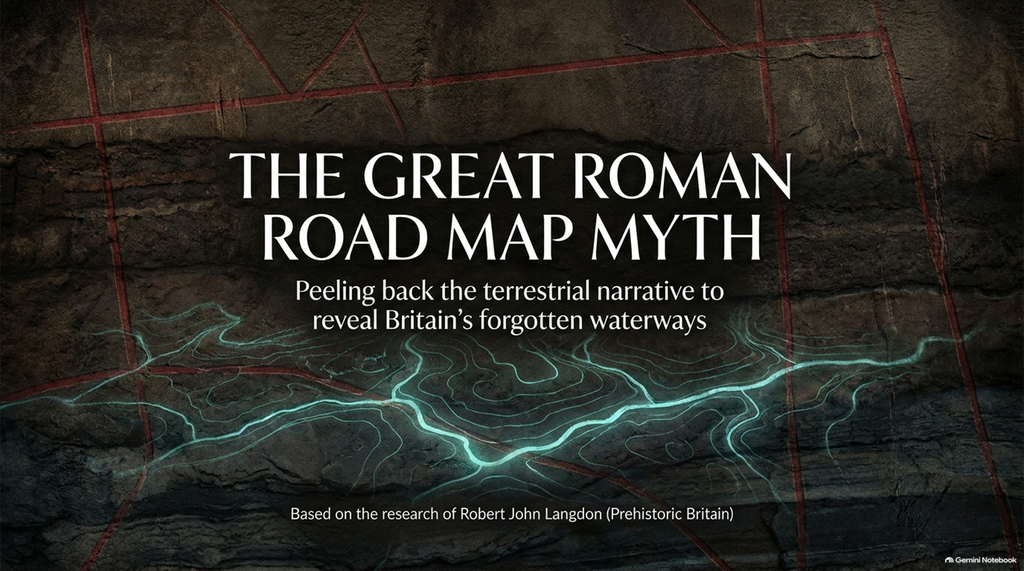
THE GREAT ROMAN ROAD MAP MYTH
New Peer-Reviewed Evidence Reveals the Missing Waterways of Roman Britain
Why the latest scientific research reinforces our Ackling Dyke investigations and challenges the traditional road-centred interpretation of Britain’s ancient transport network.
By Robert John Langdon | Prehistoric Britain | November 2026
Introduction – Have We Been Looking at Britain’s Ancient Transport Network the Wrong Way?
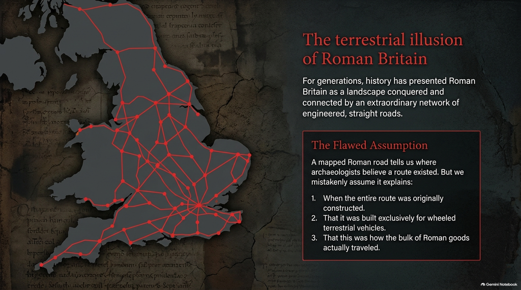
For generations, the history books have presented Roman Britain as a landscape transformed by an extraordinary network of roads. Straight lines stretch across archaeological maps, connecting military forts, towns and settlements in what appears to be a carefully planned system of terrestrial communications.
But this familiar picture has a fundamental problem.
A mapped Roman road tells us where archaeologists believe a route existed. It does not necessarily explain when every part of that route was first constructed, what earlier structures it may have incorporated, or how the bulk of the goods consumed by Roman society reached their destinations.
These are very different questions.
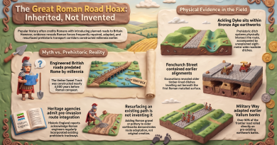
In our recent investigations of Ackling Dyke, the supposed Roman road connecting Old Sarum in Wiltshire with Dorchester in Dorset, we have challenged the assumption that every substantial bank, cutting and ditch associated with this corridor represents a single Roman road construction project.
Our LiDAR analysis reveals a much more complex landscape, with substantial earthworks, narrow metalled surfaces, extraction pits, prehistoric linear features, and connections to ancient watercourses.
We propose that parts of the corridor could represent an earlier transport system, later adapted by Roman engineers.
Two independently published archaeological studies now provide important additional evidence for reconsidering the economic assumptions behind Britain’s conventional Roman road map.
The latest appeared in the prestigious peer-reviewed journal Antiquity in September 2026.
Its findings deserve far more attention than another coloured line on an Ordnance Survey map.
1. The New Evidence – 254 Excavations and Roman Trade Across Western Europe
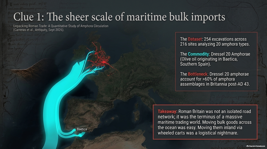
The research paper, Unpacking Roman Trade: A Quantitative Study of Amphora Circulation in the Western Provinces, was published by Cèsar Carreras, Tom Brughmans, Pau de Soto Cañamares and Daniel Blumenkranz.
Rather than relying on the presumed location of ancient roads, the researchers examined the physical remains of Roman trade.
Their study compiled evidence from 254 archaeological excavations across 216 sites and investigated the distribution of 20 common amphora types.
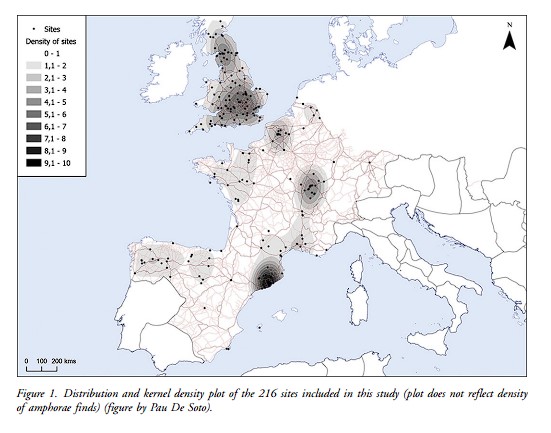
Amphorae were ceramic containers used primarily to transport wine, olive oil and fish products, often over considerable distances.
Their origins can frequently be identified through distinctive shapes, manufacturing techniques and ceramic materials.
Consequently, an amphora manufactured in southern Spain and excavated in Britain provides evidence that goods moved between those regions, regardless of what a modern archaeological map proposes about the connecting infrastructure.
The researchers used standardised measurements and probabilistic dating techniques to analyse the geographical distribution of these containers.
Their findings demonstrate extensive long-distance commercial exchange, particularly during the late Republican and early Imperial periods.
For our purposes, the important question is not simply what was being traded.
It is how these substantial quantities of goods were being transported.
The study identifies a major commercial system linking the Mediterranean production centres with Britain’s Atlantic-facing markets.
These maritime connections were essential components of the Roman economy.
And they introduce an important distinction often lost in popular accounts of Roman engineering:
A network of roads can exist without being the principal means of transporting long-distance bulk commodities.
Source: Carreras et al. (2026), Antiquity, pp. 1–7.
2. The Spanish Olive Oil That Reached Roman Britain
Perhaps the most revealing evidence concerns a ceramic container known as the Dressel 20 amphora.
These large vessels originated principally in Baetica, a Roman province corresponding broadly to southern Spain.
Their contents were olive oil.
The geographical distances involved are remarkable.
Oil produced in the Guadalquivir valley was exported to northern Europe and Britain, where it supplied military establishments, administrative centres and civilian markets.
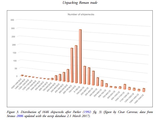
The research identifies comparatively high frequencies of these imported vessels in Roman Britain following the conquest of AD 43.
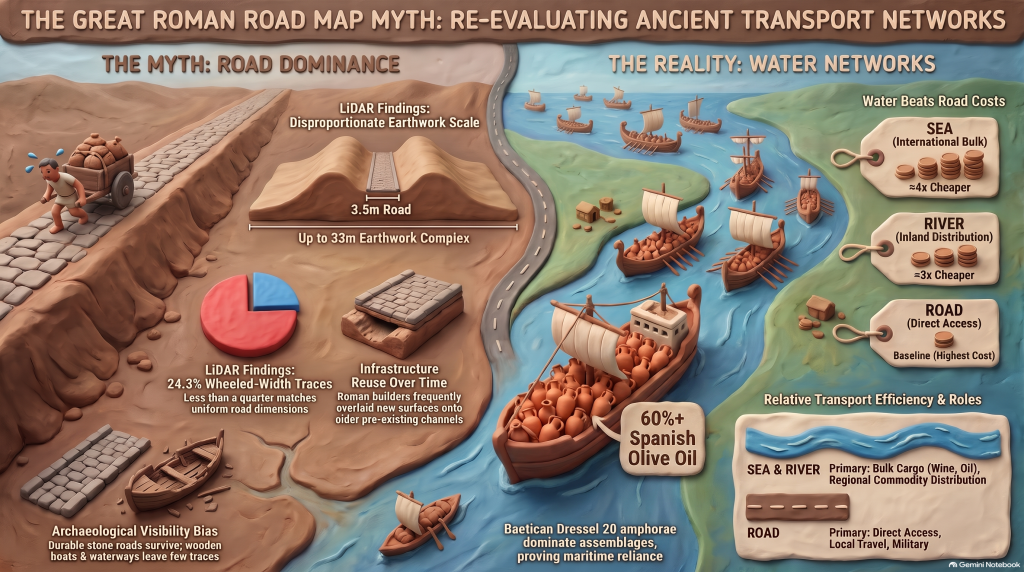
Indeed, the authors report that Baetican Dressel 20 amphorae accounted for more than 60% of amphora assemblages in several northern and western provinces, including Britannia.
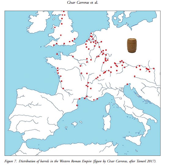
Their Figure 8 maps the geographical distribution of these containers and reveals concentrations in Britain, northern France and the German provinces.
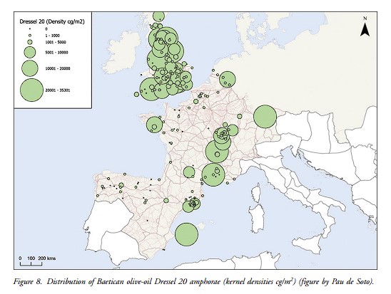
These patterns provide strong evidence of an extensive supply system dependent upon long-distance maritime connections.
The study also identifies concentrations in the Cotswolds and south-eastern Britain, including the London–Colchester corridor.
But consider the engineering implications.
A cargo of olive oil from southern Spain must first cross considerable distances before arriving at a British port.
Its subsequent movement inland presents a separate logistical problem.
Was it transported entirely by wheeled vehicles?
Was it transferred to smaller riverboats?
Were other containers used for the final stages of transportation?
The amphora evidence cannot identify every individual journey. However, the international maritime stage is unmistakable.
Britain’s Roman economy was not an isolated road network. It was part of a much larger maritime trading world.
And that brings us directly to our Ackling Dyke investigation.
3. Ackling Dyke – What Our LiDAR Investigation Actually Revealed
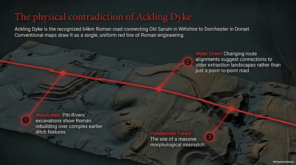
Our investigation followed approximately 64 kilometres of the recognised Old Sarum–Dorchester corridor.
Rather than assuming every surviving earthwork formed part of a uniform Roman road, we classified the physical remains by their observable morphology.
The results were revealing.
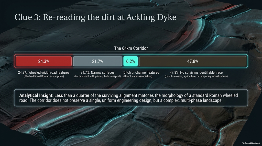
Across the surveyed alignment, we identified approximately:
- 24.3% as wheeled-width road features.
- 21.7% as narrow surfaces.
- 6.2% as ditch or channel features.
- 47.8% with no surviving identifiable trace.
These figures describe the present physical evidence, not the percentage of the route that was originally Roman or prehistoric. Missing surface traces can result from erosion, agriculture and later disturbance.
Nevertheless, they challenge the assumption that the entire mapped corridor preserves one consistent engineering design.
At Puddletown Forest, the investigation becomes particularly interesting.
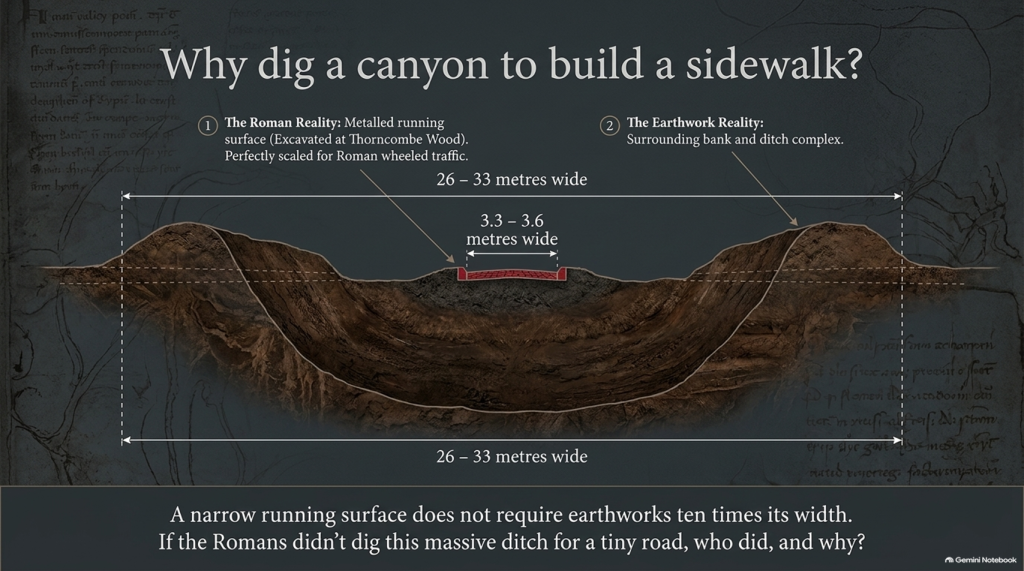
Earlier excavations at nearby Thorncombe Wood recorded a metalled running surface approximately 3.3–3.6 metres wide.
That is perfectly understandable as a road.
But elsewhere in the same landscape, substantial earthwork complexes measure approximately 26–33 metres across.
Why should a comparatively narrow running surface require earthworks approaching ten times its width?
Legitimate explanations may involve spoil removal, drainage, terrain, or multiple construction phases.
But those explanations must be demonstrated, rather than assumed.
Our investigation also identified alignment changes associated with extraction landscapes and palaeochannels.
At Wyke Down, two contrasting alignments appear to connect different parts of the landscape, raising the possibility that transport requirements changed over time.
At Woodyates, Pitt-Rivers’ excavations provide unmistakable evidence of Roman-period engineering and road construction.
However, they also document rebuilding, earlier features and complex relationships with surrounding ditches.
This is why our findings do not argue that the Romans never built or used roads.
They argue that later Roman road use cannot automatically establish the original construction date and purpose of every underlying earthwork.
If ancient Britain had a more extensive waterborne transport system than conventional road maps suggest, these relationships become particularly important.
4. The Missing Economic Argument – Boats Were Cheaper Than Roads
A second peer-reviewed study supplies an even more direct quantitative connection.
In October 2024, Rob Wiseman, Scott G. Ortman and Olivia Bulik published research in the Journal of Archaeological Science entitled:
The Costs of Transporting Goods by Different Modes: A Case Study of Pottery Movement in Late Roman Britain.
This investigation examined archaeological pottery distributions dating approximately from AD 250 to 400.
Rather than relying exclusively on historical descriptions of Roman transport, the researchers used mathematical models to test the relative costs of moving goods by road, river and sea.
Their best-fitting model suggested that:
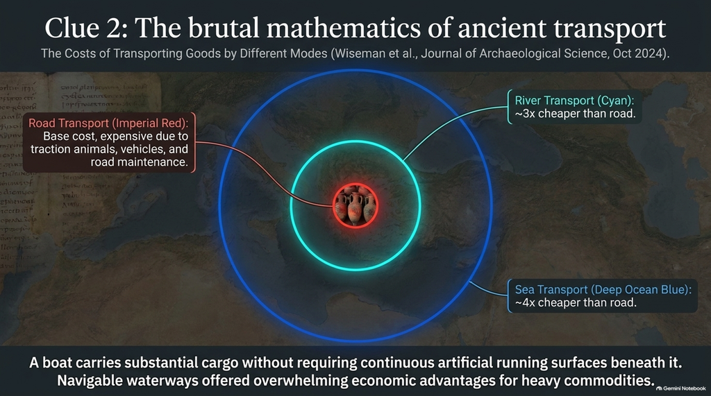
River transport was approximately three times cheaper than road transport.
Sea transport was approximately four times cheaper than road transport.
These are comparative modelling estimates, not exact prices applicable to every Roman journey. The researchers report wide confidence intervals and acknowledge uncertainties in reconstructing the ancient transport network.
Nevertheless, the economic implication is significant.
Water transport offered substantial potential advantages, especially when moving heavy commodities over long distances.
A boat could carry a substantial cargo without requiring the construction and maintenance of a continuous artificial running surface.
A road, in contrast, required an appropriate surface, traction animals, vehicles, maintenance and repeated handling of goods.
This creates an obvious question for our investigations.
If navigable waterways offered substantially lower transport costs, why should we automatically assume that every monumental linear earthwork was originally constructed primarily for wheeled traffic?
That assumption becomes especially questionable where the surviving earthwork connects with substantial palaeochannels, extraction sites or other water-associated landscape features.
It does not follow that every ditch was a canal.
It does follow that the water-transport explanation deserves testing against the physical evidence rather than being excluded by the monument’s traditional name.
5. What Happens When We Put Both Peer-Reviewed Studies Together?
The two papers investigate different subjects and periods.
Carreras and colleagues examine the changing distribution of Roman amphorae, demonstrating the importance of maritime trade, regional supply and changing commercial markets.
Wiseman and colleagues examine the relative cost of moving pottery through late Roman Britain and find substantial economic advantages to water transport.
They do not prove identical propositions.
But together they support a broader interpretation of Roman transport.
Long-distance commerce depended heavily upon maritime connections, while river and land transport formed additional parts of the distribution system.
This arrangement is considerably more complex than the familiar picture of wheeled traffic travelling endlessly between towns on straight Roman roads.
It also raises an important methodological issue.
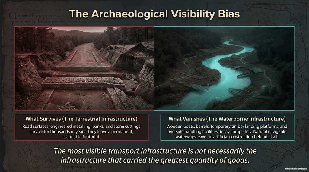
The archaeological visibility of different transport systems is not equal.
Road surfaces, banks and cuttings can survive for thousands of years.
Wooden boats, barrels, temporary landing platforms and riverside handling facilities are far less likely to survive in recognisable form.
Natural navigable waterways need not leave behind any artificial construction.
Consequently, a landscape may preserve its terrestrial infrastructure much more visibly than its waterborne economic activity.
The most visible transport infrastructure is not necessarily the infrastructure that carried the most goods.
This is precisely the distinction to consider when interpreting ancient routes such as Ackling Dyke.
6. The Post-Glacial Flooding Hypothesis – Why the Original Landscape Matters
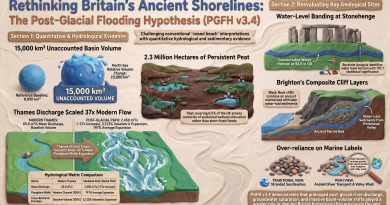
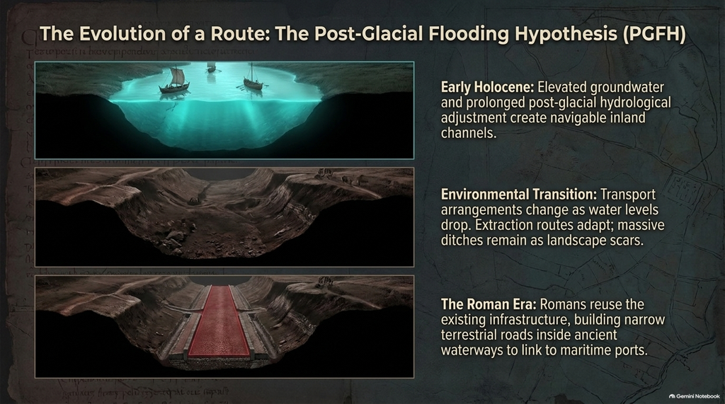
Our broader research into the Post-Glacial Flooding Hypothesis (PGFH) adds another environmental dimension.
The hypothesis proposes that elevated groundwater conditions, changing river levels and prolonged post-glacial hydrological adjustment created landscapes substantially different from those visible today.
Our work examines former river terraces, palaeochannels, peat deposits, boreholes and the geographical relationships between ancient monuments and waterways.
In the context of Ackling Dyke, this raises the possibility that some engineered earthworks originated in landscapes where water transport was more practical than it would be at the same locations today.
As water levels changed, transport arrangements could also have changed.
A channel might cease to be navigable.
A landing place might become disconnected from a river.
An extraction route might acquire a new purpose.
An earlier earthwork might subsequently be adapted for wheeled traffic.
Roman engineers entering such a landscape could have reused portions of the existing infrastructure.
However, one chronological distinction is essential.
Evidence for elevated waterways during the early Holocene does not automatically establish that those waterways remained navigable during the Roman occupation thousands of years later.
That question requires separate reconstruction of Roman-period water levels and directly dated sedimentary deposits.
The new trade research establishes the economic importance of water transport during the Roman period itself.
The PGFH provides a testable explanation for why some elements of the underlying transport landscape could be considerably older.
The two investigations therefore complement one another but are not interchangeable.
7. The Roman Road Map – A Map of Construction or a Map of Reuse?
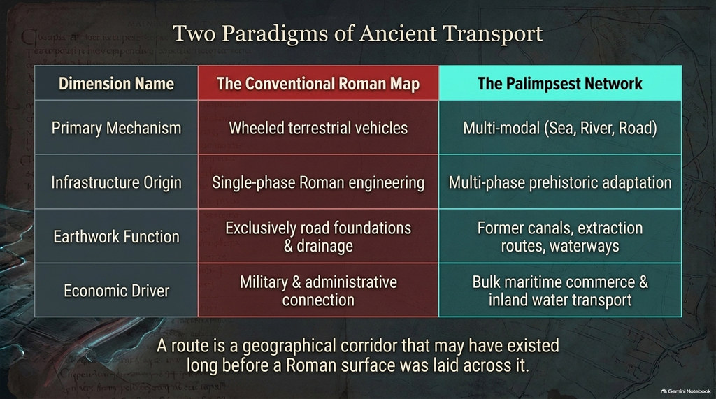
We should now reconsider what the term Roman road actually establishes.
There is no serious doubt that the Romans constructed extensive road networks throughout Britain.
Numerous excavations have recovered engineered metalling, cambered surfaces, drainage features and associated Roman-period material.
Our Ackling Dyke investigation acknowledges these discoveries.
But a road surface is a physical structure built at a particular time.
A route is a geographical corridor that may have existed long before that surface was laid.
And a monumental earthwork is not necessarily synonymous with the road subsequently constructed across or beside it.
These distinctions are fundamental.
If archaeologists identify Roman construction on part of a route, it does not automatically follow that the Romans built every associated bank, cutting, or ditch.
Nor does it establish that the entire corridor originally had the same function.
At Ackling Dyke, differences in the narrow road surfaces, larger earthwork complexes, and changing alignments give us good reasons to investigate multiple phases of use.
The newly published trade research reinforces the economic plausibility of water-assisted transport within the wider Roman system.
It does not directly prove a prehistoric origin for Ackling Dyke, nor does it date its earliest earthworks.
But it strengthens the case for asking whether our conventional archaeological maps have oversimplified a much older and more varied transport landscape.
8. The Evidence We Must Now Look For
The Ackling Dyke hypothesis can be tested through several specific archaeological investigations.
Where we have identified possible channels, excavations should establish whether their sedimentary fills indicate sustained water movement, artificial drainage, or ordinary ditch infilling.
Where large cuttings appear near extraction sites, the construction sequence should be examined to establish whether excavation, transport and later road engineering occurred in separate phases.
Palaeochannel connections should be assessed against reconstructed water levels, channel gradients and the depth necessary for navigation.
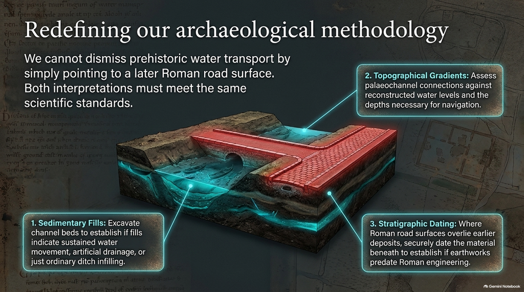
Where Roman road surfaces overlie earlier deposits, securely dated material beneath those surfaces could establish whether the underlying earthworks predate Roman engineering.
And where ancient waterways intersect the recognised route, archaeological surveys could investigate possible loading areas, landing places and cargo-handling facilities.
These are measurable questions.
They cannot be answered by simply identifying a linear feature on LiDAR and calling it a canal.
But neither should they be dismissed by pointing to a later Roman road surface and declaring the entire underlying structure Roman.
Both interpretations must meet the same scientific standards.
Conclusion – Britain’s Forgotten Transport Network
The conventional maps of Roman Britain are useful records of known and proposed routes.
But they should not be confused with complete reconstructions of how the ancient economy functioned.
The new Antiquity investigation reveals the extensive circulation of imported products through maritime trade.
The 2024 Journal of Archaeological Science study supplies quantitative evidence that water transport offered significant potential cost advantages over roads.
And our Ackling Dyke investigations identify a corridor whose surviving physical features are far more complex than a single, uniform Roman road.
Together, these findings demand a broader question.
Were Britain’s ancient roads the foundation of its transport economy, or were many of them later terrestrial additions to a landscape already organised around rivers, ports, extraction routes and maritime commerce?
The answer is unlikely to be exclusively one or the other.
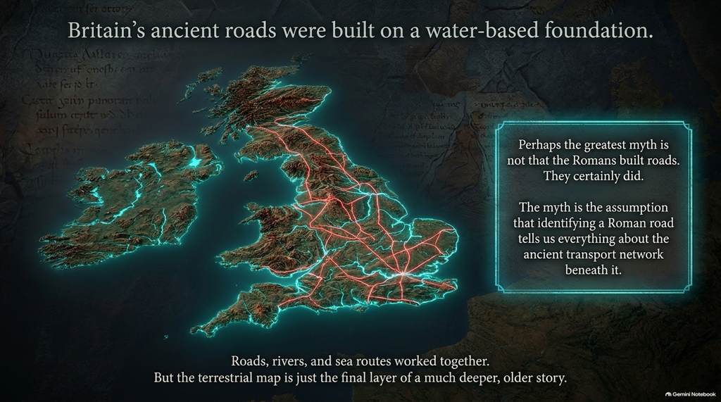
Roads, rivers and sea routes undoubtedly worked together.
But determining which elements came first, and which carried the greatest share of economic activity, requires more than simply identifying every substantial linear feature as Roman engineering.
Our Ackling Dyke research suggests that parts of the surviving landscape may preserve an older and more complex system.
The peer-reviewed trade evidence provides an economic reason to seriously investigate such a system.
Perhaps the greatest myth is not that the Romans built roads. They certainly did.
The assumption is that identifying a Roman road tells us everything about the ancient transport network beneath it.
The surviving evidence suggests there is a much bigger story still to investigate.
References and Further Reading
Langdon, R. J. (2026). Ackling Dyke Reconsidered – An Investigation. Prehistoric Britain. https://prehistoricbritain.co.uk/blog-post/ackling-dyke-reconsidered-an-investigation/
Carreras, C., Brughmans, T., de Soto Cañamares, P. & Blumenkranz, D. (2026). Unpacking Roman Trade: A Quantitative Study of Amphora Circulation in the Western Provinces. Antiquity, 1–18. https://doi.org/10.15184/aqy.2026.10429
Wiseman, R., Ortman, S. G. & Bulik, O. (2024). The Costs of Transporting Goods by Different Modes: A Case Study of Pottery Movement in Late Roman Britain. Journal of Archaeological Science, 170, 106059. https://doi.org/10.1016/j.jas.2024.106059
Langdon, R. J. (2026). Ackling Dyke – Facts and the Archaeological Fiction. Prehistoric Britain. https://prehistoric-britain.co.uk/ackling-dyke-facts-and-the-archaeological-fiction
Langdon, R. J. (2026). Ackling Dyke – Part II: Puddletown Forest – When a Roman Road Becomes an Assumption. https://prehistoric-britain.co.uk/ackling-dyke-part-ii-puddletown-forest-when-a-roman-road-becomes-an-assumption
Langdon, R. J. (2026). Ackling Dyke at Woodyates – Part III: What Pitt-Rivers Actually Proved and What Modern LiDAR Now Reveals. https://prehistoric-britain.co.uk/ackling-dyke-at-woodyates-part-iii-what-pitt-rivers-actually-proved-and-what-modern-lidar-now-reveal
Fletcher, M. (2004). The Ackling Dyke Roman Road in Puddletown Forest, Dorset. English Heritage Archaeological Investigation Report 37/2004, subsequently Historic England Research Report 103/2004.
Langdon, R. J. (2026). The Post-Glacial Flooding Hypothesis – The Evidence, version 3.4. ABC Publishing Group.
Podcast

Author’s Biography
Robert John Langdon, a polymathic luminary, emerges as a writer, historian, and eminent specialist in LiDAR Landscape Archaeology.
His intellectual journey has included stints as an astute scrutineer in government and major corporate bastions, spanning British Telecommunications, Cable and Wireless, British Gas, and the esteemed University of London.
A decade hence, Robert’s transition into retirement unfurled a chapter of insatiable curiosity. He immersed himself in Politics, Archaeology, Philosophy, and the enigmatic realm of Quantum Mechanics. His academic odyssey took him through the venerable corridors of knowledge hubs such as the Museum of London, University College London, Birkbeck College, The City Literature Institute, and Chichester University.
In the symphony of his life, Robert is a custodian of three progeny and a pair of cherished grandchildren. His sanctuary lies ensconced in the embrace of West Wales, where he inhabits an isolated cottage, its windows framing a vista of the boundless sea – a retreat from the scrutinising gaze of Her Majesty’s Revenue and Customs, an amiable clandestinity in the lap of nature.
Exploring Prehistoric Britain: A Journey Through Time
My blog delves into the fascinating mysteries of prehistoric Britain, challenging conventional narratives and offering fresh perspectives grounded in cutting-edge research, particularly LiDAR technology. I invite you to explore some key areas of my research. For example, I re-examine the Wansdyke, often cited as a defensive structure, in light of new evidence. I’ve presented my findings in my blog post Wansdyke: A British Frontier Wall – ‘Debunked’, and a Wansdyke LiDAR Flyover video further visualises my conclusions.
My work also often challenges established archaeological dogma. I argue that many sites, such as Hambledon Hill, commonly identified as Iron Age hillforts, are not what they seem. My posts Lidar Investigation Hambledon Hill – NOT an ‘Iron Age Fort’ and Unmasking the “Iron Age Hillfort” Myth explore these ideas in detail and offer an alternative view. Similarly, I re-evaluated sites like Cissbury Ring and White Sheet Camp through LiDAR analysis in my posts “Lidar Investigation Cissbury Ring through time” and “Lidar Investigation White Sheet Camp,“ revealing fascinating insights into their true purpose. I have also examined South Cadbury Castle, often linked to the mythical Camelot56.
My research also extends to ancient water management, including the role of canals and other linear earthworks. I have discussed the true origins of Car Dyke in multiple posts, including Car Dyke – ABC News Podcast and Lidar Investigation Car Dyke – North Section, which suggest a Mesolithic origin 2357. I also explore the misidentification of Roman aqueducts, as seen in my posts on the Great Chesters (Roman) Aqueduct. My research has also been shaped by my post-glacial flooding hypothesis, which helps explain landscape transformations over time. I have discussed this hypothesis in several posts, including AI now supports my Post-Glacial Flooding Hypothesis and Exploring Britain’s Flooded Past: A Personal Journey
Finally, my blog also investigates prehistoric burial practices, as seen in Prehistoric Burial Practices of Britain and explores the mystery of Pillow Mounds, often mistaken for medieval rabbit warrens, but with a potential link to Bronze Age cremation in my posts: Pillow Mounds: A Bronze Age Legacy of Cremation? and The Mystery of Pillow Mounds: Are They Really Medieval Rabbit Warrens?. My research also includes astronomical insights into ancient sites, for example, in Rediscovering the Winter Solstice: The Original Winter Festival. I also review new information about Stonehenge’s construction in The Stonehenge Enigma.
Yes. I’d make this far tighter, more inviting and more obviously a gateway into the rest of your work. The present version repeats the website several times and reads more like an author biography than a “what next?” section.
I’d also make the three routes immediately obvious: Explore the Research → Watch the Videos → Read the Books, with Facebook as the discussion/community route.
Further Reading — Explore the Evidence
The investigation doesn’t end with this article.
Prehistoric Britain brings together hundreds of articles, LiDAR investigations, field discoveries, archaeological studies, and original research that explore Britain’s prehistoric landscape from a different perspective.
Follow the evidence across ancient waterways, lost landscapes, Stonehenge and Avebury, prehistoric engineering, submerged Britain, ancient DNA and the effects of post-glacial flooding — comparing established archaeological interpretations with alternative explanations suggested by the physical evidence.
🎬 Watch the Investigations
Prefer to watch rather than read?
The Robert John Langdon YouTube channel has more than 200 documentaries, investigations, and video presentations that bring the research to life through maps, LiDAR, archaeological evidence, and landscape reconstruction.
Discover investigations including 13 Things That Don’t Make Sense in History, Silbury Avenue – The Lost Stone Avenue, Stonehenge, prehistoric waterways, submerged landscapes and many more.
📚 Explore the Book Library
Go deeper into the evidence through Robert John Langdon’s growing collection of books and specialist studies, including:
- The Stonehenge Hoax – 13 Things That Don’t Make Sense in History
- Car Dyke – Prehistoric Dyke
- Wansdyke – Prehistoric Dyke
- Offa’s Dyke – Prehistoric Dyke
- Silbury Avenue – The Lost Stone Avenue
- The Vallum – At Hadrian’s Wall
- Stonehenge: The World’s First Computer
- Avebury’s Lost Stone Avenue
Many of these investigations connect directly with the evidence discussed throughout the website, allowing individual discoveries to be examined as part of the much wider prehistoric landscape.
🔎 Read the Main Trilogy
Three major works bring together the central strands of the research:
The Post-Glacial Flooding Hypothesis — investigates the evidence for radically different water levels, waterways and landscapes in prehistoric Britain.
The Stonehenge Enigma — re-examines the chronology, landscape and purpose of one of the world’s most famous prehistoric monuments.
Dawn of the Lost Civilisation — explores the evidence for sophisticated communities, technology and maritime connections far earlier than traditionally assumed.
💬 Join the Investigation
New discoveries, LiDAR surveys and research are discussed as they happen in the Prehistoric Britain Facebook Group.
Join the discussion, challenge the evidence, offer alternative interpretations and follow new investigations as they develop.
Don’t just read the accepted story. Explore the evidence, compare the interpretations, and decide for yourself.
Other Blogs
1
a
- Ackling Dyke – Facts and the Archaeological Fiction
- Ackling Dyke – Part II – Puddletown Forest: When a Roman Road Becomes an Assumption
- Ackling Dyke – Part III – The Roman Road Mystery Finally Makes Sense
- AI now Supports – Homo Superior
- AI now supports my Post-Glacial Flooding Hypothesis
- Alexander the Great sailed into India – where no rivers exist today
- Ancient Secrets of Althorp – debunked
- Antler Picks built Ancient Monuments – yet there is no real evidence
- Antonine Wall – Prehistoric Canals (Dykes)
- Archaeological ‘pulp fiction’ – has archaeology turned from science?
- Archaeological Pseudoscience
- Archaeology in the Post-Truth Era
- Archaeology: A Bad Science?
- Archaeology: A Harbour for Fantasists?
- Archaeology: Fact or Fiction?
- Archaeology: The Flaws of Peer Review
- Archaeology’s Bayesian Mistake: Stop Averaging the Past
- Are Raised Beaches Archaeological Pseudoscience?
- Atlantis Found: The Mathematical Proof That Plato’s Lost City Was Doggerland
- ATLANTIS: Discovery with Dan Snow Debunked
- Avebury Ditch – Avebury Phase 2
- Avebury through time
- Avebury’s great mystery revealed
- Avebury’s Lost Stone Avenue – Flipbook
b
- Battlesbury Hill – Wiltshire
- Beyond Stone and Bone: Rethinking the Megalithic Architects of Northern Europe
- BGS Prehistoric River Map
- Blackhenge: Debunking the Media misinterpretation of the Stonehenge Builders
- Brain capacity (Cro-Magnon Man)
- Britain’s Changing Funeral Traditions
- Britain’s First Road – Stonehenge Avenue
- Britain’s Giant Prehistoric Waterways
- British Roman Ports miles away from the coast
c
- Caerfai Promontory Fort – Archaeological Nonsense
- Car Dyke – ABC News PodCast
- Car Dyke – North Section
- Cardigan Bay: The Holocene Evidence the Old Geological Story Has Missed
- CASE STUDY – An Inconvenient TRUTH (Craig Rhos Y Felin)
- Case Study – River Avon
- Case Study – Woodhenge Reconstruction
- Chapter 2 – Craig Rhos-Y-Felin Debunked
- Chapter 2 – Stonehenge Phase I
- Chapter 2 – Variation of the Species
- Chapter 3 – Post Glacial Sea Levels
- Chapter 3 – Stonehenge Phase II
- Chapter 7 – Britain’s Post-Glacial Flooding
- Cissbury Ring through time
- Clement Reid, Doggerland, and the Archaeological Establishment
- Cro-Magnon Brain Capacity
- Cro-Magnon Megalithic Builders: Measurement, Biology, and the DNA
- Cro-Magnons – An Explainer
d
- Darwin’s Children – Flipbook
- Darwin’s Children – The Cro-Magnons
- Dawn of The Lost Civilisation – 1/10
- Dawn of the Lost Civilisation – Flipbook
- Dawn of the Lost Civilisation – Introduction
- Digging for Britain – Cerne Abbas
- Digging for Britain Debunked – Cerne Abbas 2
- Digging Up Britain’s Past – Debunked
- DLC Chapter 1 – The Ascent of Man
- Durrington Walls – Woodhenge through time
- Durrington Walls Revisited: Platforms, Fish Traps, and a Managed Mesolithic Landscape
- Dyke Construction – Hydrology 101
- Dykes Ditches and Earthworks
- DYKES of Britain
e
f
g
h
- Hadrian’s Wall – Military Way Hoax
- Hadrian’s Wall – the Stanegate Hoax
- Hadrian’s Wall Vallum – Prehistoric Canals – FREE Online Book
- Hadrian’s Wall LiDAR investigation
- Hambledon Hill – NOT an ‘Iron Age Fort’
- Hayling Island Lidar Maps
- Hidden Sources of Ancient Dykes: Tracing Underground Groundwater Fractals
- Historic River Avon
- Hollingsbury Camp Brighton – A Hillfort… or a Forgotten Harbour?
- Hollows, Sunken Lanes and Palaeochannels
- Homo Superior – Flipbook
- Homo Superior – History’s Giants
- How Lidar will change Archaeology
- Hydrology 101 Simplified: Why Britain’s Dykes Worked Without Rivers
i
l
m
- Maiden Castle through time
- Mathematics Meets Archaeology: Discovering the Mesolithic Origins of Car Dyke
- Mesolithic River Avon
- Mesolithic Stonehenge
- Minerals found in Prehistoric and Roman Quarries
- Mining in the Prehistoric to Roman Period
- Mount Caburn through time
- Mysteries of the Oldest Boatyard Uncovered
- Mythological Dragons – a non-existent animal that is shared by the World.
o
- Offa’s Dyke Flipbook
- Old Sarum Lidar Map
- Old Sarum Through Time…………….
- On Sunken Lands of the North Sea – Lived the World’s Greatest Civilisation.
- OSL Chronicles: Questioning Time in the Geological Tale of the Avon Valley
- Oswestry LiDAR Survey
- Oswestry through time
- Oysters in Archaeology: Nature’s Ancient Water Filters?
p
- Pillow Mounds: A Bronze Age Legacy of Cremation?
- Pinkery Canal
- Plato Was Right: The Archaeological Evidence the Academics Never Expected
- Post Glacial Flooding – Flipbook
- Prehistoric Burial Practices of Britain
- Prehistoric Canals – Wansdyke
- Prehistoric Canals – Wansdyke
- Prehistoric Canals (Dykes) – Great Chesters Aqueduct (The Vallum Pt. 4)
- Prehistoric Canals (Dykes) – Offa’s Dyke (Chepstow)
- Prehistoric Canals (Dykes) – Offa’s Dyke (LiDAR Survey)
- Prehistoric Canals (Dykes) – Offa’s Dyke Survey (End of Section A)
- Prehistoric Canals (Dykes) – Wansdyke (4)
- Prehistoric Canals Wansdyke 2
- Professor Bonkers and the mad, mad World of Archaeology
r
- Real-World Confirmation of Post-Glacial Flooding
- Rebirth in Stone: Decrypting the Winter Solstice Legacy of Stonehenge
- Rediscovering the Winter Solstice: The Original Winter Festival
- Rethinking Ancient Boundaries: The Vallum and Offa’s Dyke”
- Rethinking Ogham: Could Ireland’s Oldest Script Have Begun as a Tally System?
- Rethinking The Past: Mathematical Proof of Langdon’s Post-Glacial Flooding Hypothesis
- Revolutionising History: Car Dyke Unveiled as Prehistoric & the Launch of FusionBook 360
- Rising Evidence, Falling Rivers: The Real Story of Europe’s First Farmers
- Rivers of the Past Were Higher: A Fresh Perspective on Prehistoric Hydrology
s
- Sea Level Changes
- Section A – NY26SW
- Section B – NY25NE & NY26SE
- Section C – NY35NW
- Section D – NY35NE
- Section E – NY46SW & NY45NW
- Section F – NY46SE & NY45NE
- Section G – NY56SW
- Section H – NY56NE & NY56SE
- Section I – NY66NW
- Section J – NY66NE
- Section K – NY76NW
- Section L – NY76NE
- Section M – NY87SW & NY86NW
- Section N – NY87SE
- Section O – NY97SW & NY96NW
- Section P – NY96NE
- Section Q – NZ06NW
- Section R – NZ06NE
- Section S – NZ16NW
- Section T – NZ16NE
- Section U – NZ26NW & NZ26SW
- Section V – NZ26NE & NZ26SE
- Silbury Avenue – Avebury’s First Stone Avenue
- Silbury Hill
- Silbury Hill / Sanctuary – Avebury Phase 3
- Sky Maps of Prehistoric Britain
- Somerset Plain – Signs of Post-Glacial Flooding
- South Cadbury Castle – Camelot
- Statonbury Camp near Bath – an example of West Wansdyke
- Stone me – the druids are looking the wrong way on Solstice day
- Stone Transportation and Dumb Censorship
- Stonehenge – Monument to the Dead
- Stonehenge Hoax – Dating the Monument
- Stonehenge Hoax – Round Monument?
- Stonehenge Hoax – Summer Solstice
- Stonehenge LiDAR tour
- Stonehenge Phase 1 — Britain’s First Monument
- Stonehenge Phase I (The Stonehenge Landscape)
- Stonehenge Solved – Pythagorean maths put to use 4,000 years before he was born
- Stonehenge Through Time
- Stonehenge, Doggerland and Atlantis connection
- Stonehenge: Borehole Evidence of Post-Glacial Flooding
- Stonehenge: Discovery with Dan Snow Debunked
- Stonehenge: The World’s First Computer – FREE Book
- Stonehenge: The Worlds First Computer
- Stonehenge’s The Lost Circle Revealed – DEBUNKED
- Stonehenge’s Chronological Mirage
t
- Ten Reasons Why Car Dyke Blows Britain’s Earthwork Myths Out of the Water
- Ten Things You Didn’t Know About Britain’s Prehistoric Flooded Past
- Ten thousand year old boats found on Northern Europe’s Hillsides
- Ten thousand-year-old boats found on Northern Europe’s Hillsides
- Testing Plato’s Atlantis Against Reality
- The “Hunter-Gatherer” Myth: Why It’s Time to Bury This Outdated Term
- The Ackling Dyke Smoking Gun
- The Ancient Mariners – Flipbook
- The Ancient Mariners – Prehistoric seafarers of the Mesolithic
- The Ascent of Man — From Survival to Systems
- The Beringian Migration Myth: Why the Peopling of the Americas by Foot is Mathematically and Logistically Impossible
- The Bluestone Enigma
- The Bulford Hoax: The “Simpler, Older Stonehenge” That Wasn’t
- The Cheddar Man Hoax
- The Cro-Magnon Cover-Up: How DNA and PR Labels Erased Our Real Ancestry
- The Dolmen and Long Barrow Connection
- The Durrington Mega-Monument Hoax: What Lies Beneath? – Debunked
- The Durrington Walls Hoax – it’s not a henge?
- The Dyke Myth Collapses: Excavation and Dating Prove Britain’s Great Dykes Are Prehistoric Canals
- The First European Smelted Bronzes
- The Fury of the Past: Natural Disasters in Historical and Prehistoric Britain
- The Giant’s Graves of Cumbria
- The Giants of Prehistory: Cro-Magnon and the Ancient Monuments
- The Great Ancient DNA Illusion: How Statistical Models Became Archaeological “Facts”
- The Great Antler Pick Hoax
- The Great Bell Beaker Migration Myth
- The Great Chichester Hoax – A Bridge too far?
- The Great Dorchester Aqueduct Hoax
- The Great Farming Hoax – (Einkorn Wheat)
- The Great Farming Migration Hoax
- The Great Hadrian’s Wall Hoax
- The Great Iron Age Hill Fort Hoax
- The Great Offa’s Dyke Hoax
- The Great Prehistoric Migration Hoax
- THE GREAT ROMAN ROAD HOAX
- THE GREAT ROMAN ROAD MAP MYTH
- The Great Stone Transportation Hoax
- The Great Stonehenge Hoax
- The Great Wansdyke Hoax
- THE GREAT WEST WOODS HOAX — WHEN ONE STONE BECOMES FIFTY
- The Henge and River Relationship
- The Logistical Impossibility of Defending Maiden Castle
- The Long Barrow and Dolmen Enigma
- The Long Barrow Mystery
- The Long Barrow Mystery: Unravelling Ancient Connections
- The Lost Island of Avalon – revealed
- The Maiden Way Hoax – A Closer Look at an Ancient Road’s Hidden History
- The Maths – LGM total ice volume
- The Mystery of Pillow Mounds: Are They Really Medieval Rabbit Warrens?
- THE ODYSSEY PROBLEM: WHY DID A WEEK-LONG VOYAGE BECOME A TEN-YEAR EPIC?
- The Old Sarum Hoax
- The Oldest Boat Yard in the World found in Wales
- The Perils of Paradigm Shifts: Why Unconventional Hypotheses Get Branded as Pseudoscience
- The Post-Glacial Flooding Hypothesis – 1/11
- The Post-Glacial Flooding Hypothesis – Flipbook
- The Post-Glacial Flooding Theory
- The Problem with Hadrian’s Vallum
- The Rise of the Cro-Magnon (Homo Superior)
- The Roman Military Way Hoax
- The Silbury Hill Lighthouse?
- The Stone Money – Credit System
- The Stonehenge Avenue
- The Stonehenge Avenue
- The Stonehenge Code: Unveiling its 10,000-Year-Old Secret
- The Stonehenge Crescent: A Monument to a Lost World
- The Stonehenge Enigma – Flipbook
- The Stonehenge Enigma: Part 1/6
- The Stonehenge Hoax – Bluestone Quarry Site
- The Stonehenge Hoax – Flipbook
- The Stonehenge Hoax – Moving the Bluestones
- The Stonehenge Hoax – Periglacial Stripes
- The Stonehenge Hoax – Station Stones
- The Stonehenge Hoax – Stonehenge’s Location
- The Stonehenge Hoax – The Ditch
- The Stonehenge Hoax – The Slaughter Stone
- The Stonehenge Hoax – The Stonehenge Layer
- The Stonehenge Hoax – Totem Poles
- The Stonehenge Hoax – Woodhenge
- The Stonehenge Hospital
- The Stonehenge Transportation Mystery
- The Subtropical Britain Hoax
- The Troy, Hyperborea and Atlantis Connection
- The Vallum @ Hadrian’s Wall – it’s Prehistoric!
- The Vallum at Hadrian’s Wall (Summary)
- The Woodhenge Hoax
- Thirty Years of CAU Archaeology Going Nowhere?
- Three Dykes – Kidland Forest
- Thurnam’s 137 Skulls: The Forgotten People Behind Britain’s Megaliths.
- Top Ten Misidentified Fire Beacons in British History
- Troy Debunked – Troy did not exist in Asia Minor, but in fact, the North Sea island of Doggerland
- TSE – DVD Barrows
- TSE DVD – An Inconvenient Truth
- TSE DVD – Antler Picks
- TSE DVD – Avebury
- TSE DVD – Durrington Walls & Woodhenge
- TSE DVD – Dykes
- TSE DVD – Epilogue
- TSE DVD – Stonehenge Phase I
- TSE DVD – Stonehenge Phase II
- TSE DVD – The Post-Glacial Hypothesis
- TSE DVD Introduction
- TSE DVD Old Sarum
- Twigs, Charcoal, and the Death of the Saxon Dyke Myth
w
- Wansdyke – Short Film
- Wansdyke East – Prehistoric Canals
- Wansdyke Flipbook
- Wansdyke LiDAR Flyover
- Wansdyke: A British Frontier Wall – ‘Debunked’
- Was Columbus the first European to reach America?
- What Archaeology Missed Beneath Stonehenge
- White Sheet Camp
- Why a Simple Fence Beats a Massive Dyke (and What That Means for History)
- Windmill Hill – Avebury Phase 1
- Winter Solstice – Science, Propaganda and Indoctrination
- Woodhenge – the World’s First Lighthouse?