Ackling Dyke – Part II – Puddletown Forest: When a Roman Road Becomes an Assumption
The second investigation into Ackling Dyke
Our investigation of Ackling Dyke has now moved south-west to Puddletown Forest and Duddle Heath, approximately four kilometres north-east of Dorchester.
This is an important test area because here we finally have something much better than a line printed on an Ordnance Survey map.
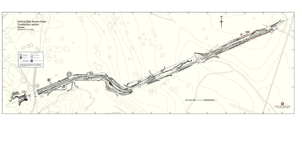
In 2004 English Heritage undertook a detailed analytical survey of approximately 1.75 km of the supposed Ackling Dyke Roman road through Puddletown Forest. They surveyed and mapped the surviving earthworks in detail, and used earlier excavations at Thorncombe Wood, Bere Down, and elsewhere to interpret their construction.
If the conventional explanation of Ackling Dyke is correct, this ought therefore to be one of the strongest places in which to demonstrate it.
Instead, the deeper we investigated the evidence, the stranger the story became.
Historic England’s own report begins its background discussion with the remarkable admission:
“Very little is known about the Ackling Dyke.”
Yet throughout the remainder of the document, the feature is already described as a Roman road and its raised earthworks as an agger. Historic England
That creates the first problem.
If the question we are attempting to answer is what these earthworks actually are, calling them a Roman road before establishing their date risks building the conclusion into the investigation itself.
The map and the landscape are not the same thing
The English Heritage report contains another important admission.
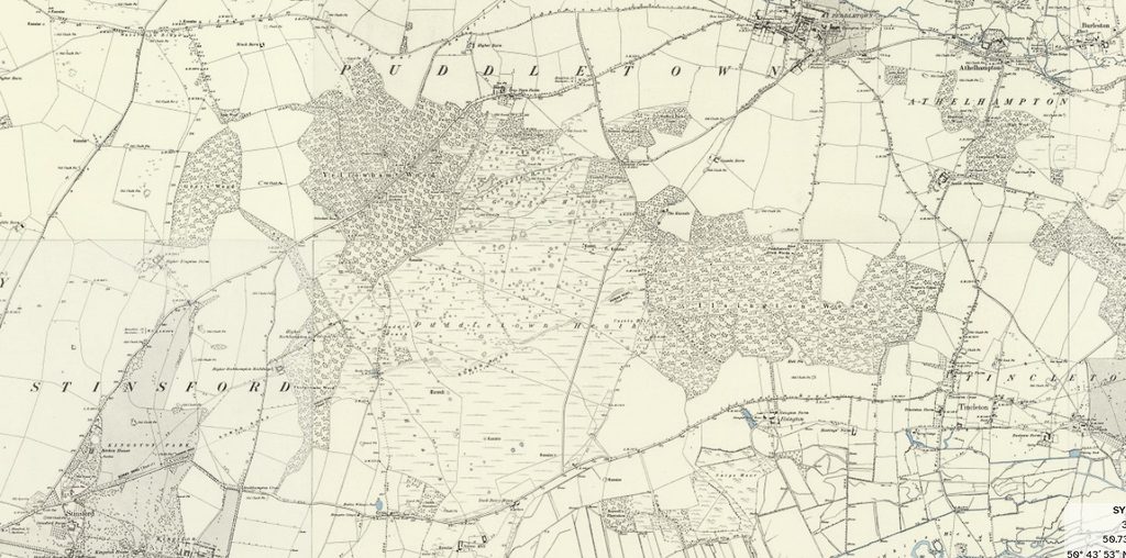
It states that the Ordnance Survey representation of Ackling Dyke, first drawn in 1889, was a “somewhat stylised depiction” and that this representation was subsequently reproduced on later maps.
That immediately raises a methodological question.
How much of the apparently continuous Roman road exists physically on the ground, and how much represents a line inherited from earlier mapping?
Modern 1 m LiDAR gives us an opportunity that the original surveyors and nineteenth-century cartographers simply did not possess.
It allows us to strip away vegetation and examine the actual three-dimensional land surface.
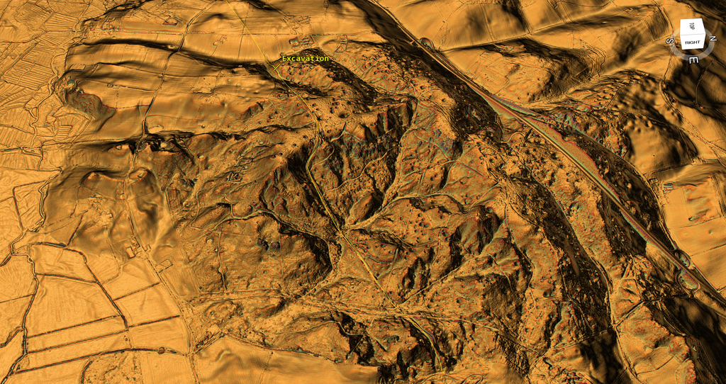
And when we do that, Puddletown Forest does not look remotely like one uniform engineered road.
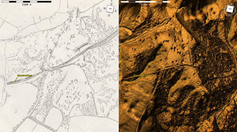
The contrast between these two images is fundamental.
The published archaeological plan records features accurately enough in two dimensions, but it visually suppresses the surrounding topography.
LiDAR exposes that topography immediately.
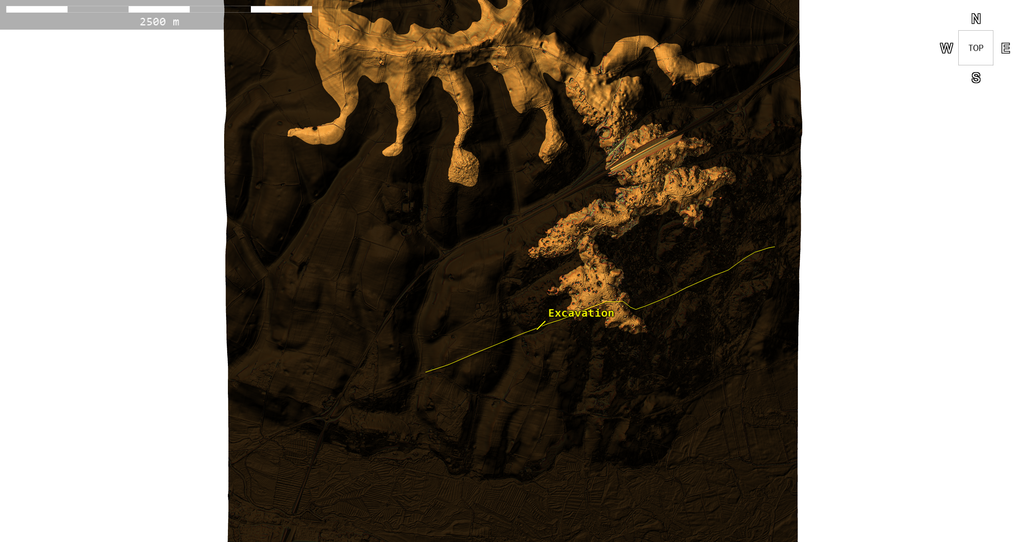
Following the supposed road for 3.315 kilometres
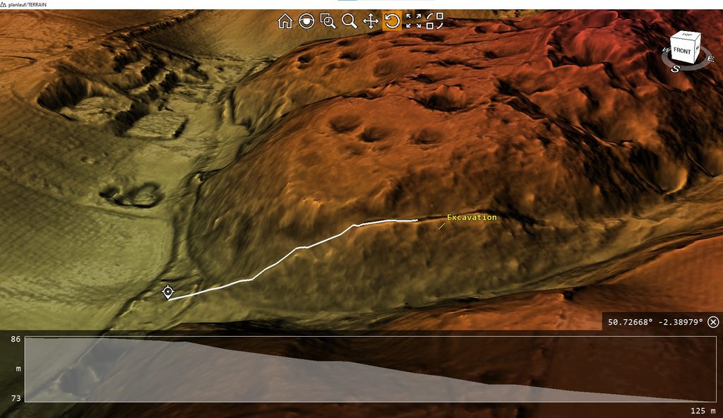
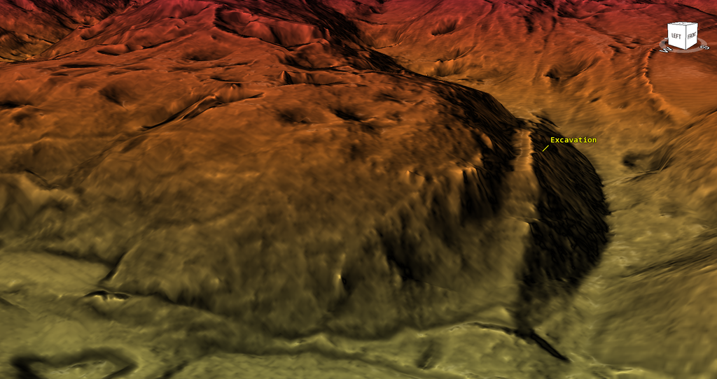
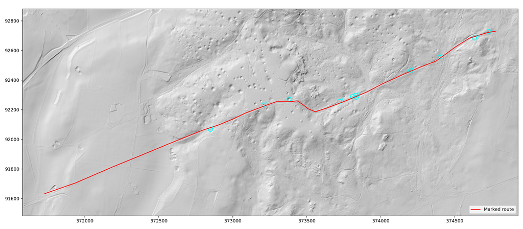
To test the road hypothesis, we manually traced the accepted alignment through the raw Environment Agency 1 m DTM.
The resulting line is 3.315 km long and includes the Puddletown survey area together with the continuation towards Thorncombe Wood.
Rather than assuming every feature the line crossed belonged to one road, we examined how the morphology changed along it.
It changes repeatedly.
The English Heritage report itself divides its 1.75 km survey into sections A-H because the physical form is so variable.
When those published section points are projected onto our LiDAR trace, they occur at approximately:
| Published section | Approx. distance along our 3.315 km trace | Published physical description |
|---|---|---|
| A-B | 1.30-1.40 km | Earlier OS investigator recorded “no trace of the agger”; area disturbed by apparent quarrying |
| B-C | 1.40-1.46 km | Short surviving raised feature; top reported about 6 m wide |
| C-D | 1.46-1.76 km | Flat-topped raised earthwork 4-6 m wide, locally ~7 m; entire complex 26-33 m wide |
| D-E | 1.76-2.00 km | Curving descent of ridge; earthwork damaged by hollow ways; total width about 24 m |
| E-F | 2.00-2.38 km | Badly disturbed by forestry tracks and quarrying; supposed road complex approximately 34 m wide |
| F-G | 2.38-2.82 km | Different alignment; total earthwork about 26 m wide, but report says agger width cannot now be ascertained |
| G-H | 2.82-2.91 km | Almost completely obscured; linear banks described only as “most probably associated with the road” |
This is not merely variation in width.
It is variation in physical type.
One section is missing. Another is a six-metre raised strip. Another becomes a 26-33 m bank-and-ditch complex. Another curves down a hillside. Another is terraced into a slope. Another has been overlaid by tracks. Another survives only as banks thought “probably” to belong to the road.
Yet throughout all those changes the archaeological label remains the same:
Roman road.
Where is the continuous Roman carriageway?
A road requires somewhere for traffic to travel.
That does not mean every Roman road must be perfectly level or exactly the same width. Roads can climb hills, descend slopes and be terraced into hillsides.
But an engineered wheeled route must possess a reasonably continuous trafficable platform.
Puddletown repeatedly changes from raised earthwork to terrace, hollow, disturbed natural slope and broad complex.
Our cross-sectional analysis illustrates those changes particularly clearly.
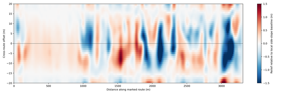
This matters because calling every raised feature an agger does not show it was constructed as part of a Roman road.
An agger is an interpretation of a bank’s function.
First we have to demonstrate the road.
The excavation that is supposed to help
The most frequently quoted local excavation was undertaken by W. Putnam in Thorncombe Wood in 1968, south-west of the principal Puddletown survey.
Precision matters here.
The Thorncombe excavation is not marked on the famous English Heritage Puddletown survey plan.
It lies farther south-west.
Putnam reportedly opened a 2 m-wide trench and found gravel metalling about 25 to 50 cm thick. Two wheel tracks were visible about 1.5 m apart.
The running surface was described as only 11-12 Roman feet wide – approximately 3.3-3.6 m.
Most significantly:
There was no ditch on either side of the agger.
That is physical evidence for a surfaced route carrying wheeled traffic at that particular location.
It is not automatically evidence that the Romans constructed the surface.
And it certainly does not demonstrate that a 26 m, 30 m or 34 m-wide earthwork kilometres away was constructed as part of the same road.
A metalled road is not a Roman date
This distinction is central.
Putnam reportedly found:
gravel + wheel ruts + a running surface.
That demonstrates an engineered road or track.
But metalling is a construction technique, not a chronological marker.
A gravel surface does not become Roman merely because it lies on a line already believed to be a Roman road.
To establish a Roman construction date independently, we would want securely associated Roman material, a stratigraphic relationship with a reliably dated Roman feature, or another independent chronological indicator.
The 2004 English Heritage summary does not provide such dating evidence for the Thorncombe metalling.
Indeed, elsewhere the same report discusses evidence that portions of Ackling Dyke may represent a late Roman realignment over an earlier route, and at Crab Farm cites the possibility that the preceding route originated in prehistory. Historic England
This is therefore an important distinction:
Road found? Yes.
Roman construction independently demonstrated at Thorncombe? Not by the evidence presented in this report.
Entire Ackling Dyke demonstrated to be one Roman construction? No.
Even English Heritage questioned the “one build”
The most revealing comments come from the report’s discussion section.
English Heritage asks whether the road is really “one build” rather than several phases.
It also acknowledges that the supposed road’s form changes with topography, that ditches disappear in places, and that parts have been overlaid, cut apart, or destroyed.
At one particularly steep ridge, the authors admit that constructing a huge raised earthwork where natural drainage already existed “begs the question about its form.”
The explanation then shifts from excavation evidence to interpretation.
The report suggests the enormous raised structure might have been intended as a statement of Roman power, even imagining sunlight reflecting from soldiers marching along the ridge.
That may be an evocative reconstruction.
It is not dating evidence.
The physical question remains unanswered:
Who constructed the underlying earthwork, and when?
Remarkably little later reuse
Another awkward observation appears in the English Heritage report.
Of approximately 27 km of Ackling Dyke between Dorchester and Badbury Rings, it notes that only about 5 km were shown overlain by metalled roads and tracks on the 1987 Ordnance Survey map.
The authors interpret this as evidence that their Roman road may have been abandoned after a surprisingly short life.
But that is interpretation again.
If a substantial engineered highway already existed between major destinations, later travellers would normally have had an economic incentive to reuse useful parts of it.
The historic map of the Puddletown area shows later routes taking other corridors.
That does not prove the Roman road never existed.
But it is another reason to ask whether the enormous continuous road drawn on later maps ever functioned as traditionally imagined.
Then there are the pits
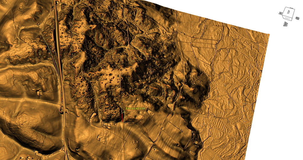
Puddletown Forest is covered with hundreds of depressions.
The conventional geological explanation identifies many as dolines or solution hollows associated with Chalk karst.
That hypothesis has a genuine scientific history.
Osmond Fisher discussed natural pits on the Dorset heaths in 1859, and in 1977 Sperling, Goudie, Stoddart and Poole carried out a substantial study of Dorset dolines, measuring width, depth, slope and other characteristics and examining geological and environmental relationships. They concluded that collapse was probably a major formation mechanism, while solution and suffosion may also have contributed. JSTOR
So we should not pretend that the geological explanation consists of nothing more than somebody looking at holes.
But an equally important limitation remains.
Those regional studies do not establish the origin of every individual depression visible in modern LiDAR.
Modern BGS guidance explicitly acknowledges that humans may have enlarged natural dolines, that artificial extraction pits can resemble natural dolines, and that some depressions may have been misclassified. British Geological Survey
Even the English Heritage Puddletown survey recognises this distinction.
It describes some depressions as deep, regular sinkholes, but separately records ragged and amorphous shallow pits averaging around a metre deep which it says resemble small quarries and could have supplied material for the earthworks – or could have served another purpose altogether.
So even within the conventional archaeological report:
not all the pits are interpreted as the same thing.
What the 1 m LiDAR actually finds
We therefore stopped arguing about appearances and measured the depressions.
Within a 2.6775 km² core area of the Puddletown landscape, our conservative automated DTM screen identified 513 robust closed depressions after excluding the smallest and shallowest candidates.
The result is an extraordinarily variable population.
| LiDAR measurement | Result |
|---|---|
| Robust depressions detected | 513 |
| Density in analysed area | ~192/km² |
| Diameter 2.5-5 m | 158 |
| Diameter 5-10 m | 187 |
| Diameter 10-15 m | 89 |
| Diameter 15-20 m | 45 |
| Diameter 20-30 m | 27 |
| Diameter 30-50 m | 7 |
| Median equivalent diameter | 7.31 m |
| Largest detected equivalent diameter | 49.39 m |
| Depth 0.25-0.5 m | 165 |
| Depth 0.5-1 m | 163 |
| Depth 1-2 m | 104 |
| Depth 2-3 m | 49 |
| Depth 3-5 m | 25 |
| Depth 5-6.75 m | 7 |
| Median apparent depth | 0.71 m |
| Maximum apparent depth | 6.75 m |
That alone does not establish human excavation.
Natural dolines can themselves vary considerably.
But it does demonstrate something important:
This is not a population of identical circular cones.
We therefore applied a second, deliberately strict geometric screen.
This was not intended as geological diagnosis. It simply asked how many features actually resembled the stereotypical single, compact, approximately circular bowl.
The result was:
| Morphological screen | Number | Percentage |
|---|---|---|
| Strict simple single-bowl form | 176 | 34.3% |
| Single minimum but irregular/non-classic form | 305 | 59.5% |
| Compound/multiple-minimum depression | 32 | 6.2% |
| Total | 513 | 100% |
Approximately two-thirds therefore fail our deliberately strict “simple bowl” test.
That does not prove two-thirds are artificial.
It proves that morphology alone cannot justify treating 513 different features as necessarily manifestations of one identical process.
Does the mapped geology solve the problem?
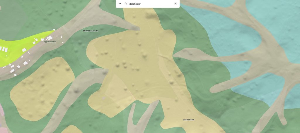
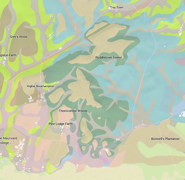
We then compared the pit field with the geological mapping.
If a single mapped superficial sand unit could explain the visible depressions, we would expect a reasonably obvious correspondence.
The overlays do not show that simple one-to-one relationship.
Pit-rich and pit-poor areas occur across the wider mapped landscape in ways that cannot simply be explained by pointing at one colour on the geological map.
That does not disprove karst.
The BGS mapping is regional, and doline formation can depend upon concealed geology, fractures, groundwater movement and varying thicknesses of superficial deposits.
But it does remove another shortcut:
A pit cannot be declared a natural sinkhole merely because it occurs somewhere within a regional geological environment capable of producing sinkholes.
You still have to demonstrate each individual feature.
The palaeochannel question
Our wider investigation of prehistoric Britain has repeatedly identified major earthworks, pits and extraction features close to former channels and reconstructed earlier water margins.
Puddletown raises the same possibility.
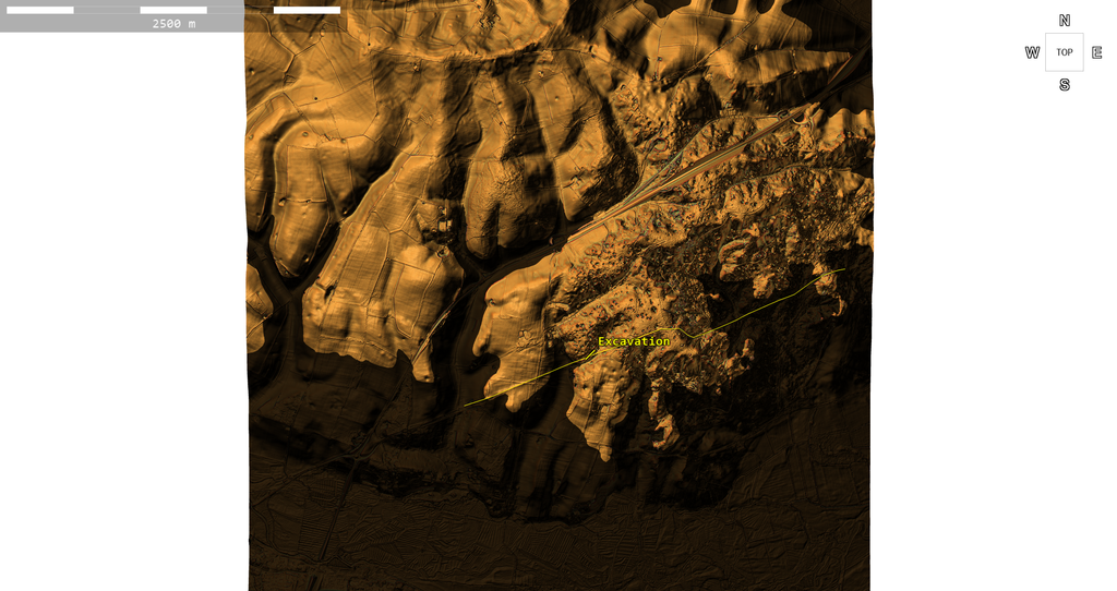
The LiDAR shows extensive low corridors penetrating the pitted uplands.
When different elevation ranges are isolated, the relationship between higher ground, lower corridors and the concentration of pits becomes visually striking.
But this must presently remain a testable hypothesis, not a demonstrated Mesolithic water level.
A percentile elevation visualisation is not, in itself, a dated shoreline.
The next question is nevertheless legitimate:
Are at least some of these pits associated more closely with former palaeochannel margins than with the supposed Roman road?
If so, Puddletown begins to fit a completely different landscape model.
A different model of Puddletown Forest
Once the assumption “this is a Roman road” is removed, the landscape becomes much easier to read as a sequence of different activities.
Our working hypothesis is now:
earlier waterways and palaeochannels
followed by
extraction and landscape working around their margins
followed by
major banks, dykes and engineered routes associated with that earlier landscape
followed, as water levels and land use changed, by
terrestrial tracks reusing convenient terraces, banks and corridors
and eventually
Roman and later traffic using or resurfacing selected portions of those older routes.
This model explains why the physical feature changes so dramatically.
It does not require every bank, ditch, terrace, hollow and metalled patch to have been constructed simultaneously for one purpose.
And that is arguably more parsimonious than explaining every contradiction as another variation of a single Roman road.
What has actually been proved?
After this investigation, the distinction is much clearer.
We have not proved that Romans never travelled along Ackling Dyke.
We have not proved that every pit at Puddletown was excavated by prehistoric people.
And we have not yet directly dated the major Puddletown earthworks to the Mesolithic or another prehistoric period.
But neither has the conventional interpretation demonstrated what is routinely presented as fact:
that the monumental and morphologically varied Ackling Dyke through Puddletown Forest was constructed as one Roman road.
The 2004 English Heritage investigation was predominantly a landscape survey, not an excavation dating the Puddletown earthworks. Historic England’s own current summary describes it as an archaeological investigation and analytical field survey. Historic England
The nearby Thorncombe excavation demonstrates a narrow metalled wheeled track.
It does not independently date that track as Roman.
The surveyed monument changes repeatedly in width and form.
In some places there is no trace of the alleged agger.
Elsewhere its width cannot be established.
Elsewhere banks are only “most probably associated” with the road.
Forestry tracks themselves are described as looking remarkably like cambered and metalled Roman aggers.
The report acknowledges uncertainty over whether the monument represents a single build or several phases.
And the surrounding pit field consists of hundreds of morphologically diverse depressions whose individual origins have never been demonstrated merely by assigning the regional label “sinkhole.”
Conclusion – evidence before labels
Puddletown Forest is an excellent example of why modern LiDAR matters.
Nineteenth-century mapping connected a series of features and labelled the result a Roman road.
Twentieth-century archaeology inherited that line.
Banks became aggers.
Ditches became road drainage.
Terraces became Roman engineering.
Changes of direction became Roman adaptations to terrain.
Metalling became evidence for a Roman route.
And even the huge investment required to build an apparently unnecessary raised causeway was eventually explained as a possible statement of Roman power.
The alternative approach is much simpler:
Remove the label and examine the physical landscape first.
When we do that, Puddletown Forest is not one uniform structure.
It is a complex, multi-phase landscape.
There are real tracks.
There are real raised earthworks.
There are ditches.
There are terraces.
There are pits.
There are natural geological processes.
There has been quarrying.
There has been forestry activity.
There are older hollow ways.
And somewhere amongst all of that there may well have been Roman traffic.
But that is very different from proving that the whole thing was built by the Romans as Ackling Dyke Roman Road.
The strongest conclusion from Puddletown, therefore, is not that archaeology has proved a Roman road.
It is that the Roman-road interpretation still needs proof.
And modern LiDAR has made that burden of proof considerably harder to avoid.
Podcast

Author’s Biography

Robert John Langdon, a polymathic luminary, emerges as a writer, historian, and eminent specialist in LiDAR Landscape Archaeology.
His intellectual journey has included stints as an astute scrutineer in government and major corporate bastions, spanning British Telecommunications, Cable and Wireless, British Gas, and the esteemed University of London.
A decade hence, Robert’s transition into retirement unfurled a chapter of insatiable curiosity. He immersed himself in Politics, Archaeology, Philosophy, and the enigmatic realm of Quantum Mechanics. His academic odyssey took him through the venerable corridors of knowledge hubs such as the Museum of London, University College London, Birkbeck College, The City Literature Institute, and Chichester University.
In the symphony of his life, Robert is a custodian of three progeny and a pair of cherished grandchildren. His sanctuary lies ensconced in the embrace of West Wales, where he inhabits an isolated cottage, its windows framing a vista of the boundless sea – a retreat from the scrutinising gaze of Her Majesty’s Revenue and Customs, an amiable clandestinity in the lap of nature.
Exploring Prehistoric Britain: A Journey Through Time
My blog delves into the fascinating mysteries of prehistoric Britain, challenging conventional narratives and offering fresh perspectives grounded in cutting-edge research, particularly LiDAR technology. I invite you to explore some key areas of my research. For example, I re-examine the Wansdyke, often cited as a defensive structure, in light of new evidence. I’ve presented my findings in my blog post Wansdyke: A British Frontier Wall – ‘Debunked’, and a Wansdyke LiDAR Flyover video further visualises my conclusions.
My work also often challenges established archaeological dogma. I argue that many sites, such as Hambledon Hill, commonly identified as Iron Age hillforts, are not what they seem. My posts Lidar Investigation Hambledon Hill – NOT an ‘Iron Age Fort’ and Unmasking the “Iron Age Hillfort” Myth explore these ideas in detail and offer an alternative view. Similarly, I re-evaluated sites like Cissbury Ring and White Sheet Camp through LiDAR analysis in my posts “Lidar Investigation Cissbury Ring through time” and “Lidar Investigation White Sheet Camp,“ revealing fascinating insights into their true purpose. I have also examined South Cadbury Castle, often linked to the mythical Camelot56.
My research also extends to ancient water management, including the role of canals and other linear earthworks. I have discussed the true origins of Car Dyke in multiple posts, including Car Dyke – ABC News Podcast and Lidar Investigation Car Dyke – North Section, which suggest a Mesolithic origin 2357. I also explore the misidentification of Roman aqueducts, as seen in my posts on the Great Chesters (Roman) Aqueduct. My research has also been greatly informed by my post-glacial flooding hypothesis, which has helped explain landscape transformations over time. I have discussed this hypothesis in several posts, including AI now supports my Post-Glacial Flooding Hypothesis and Exploring Britain’s Flooded Past: A Personal Journey
Finally, my blog also investigates prehistoric burial practices, as seen in Prehistoric Burial Practices of Britain and explores the mystery of Pillow Mounds, often mistaken for medieval rabbit warrens, but with a potential link to Bronze Age cremation in my posts: Pillow Mounds: A Bronze Age Legacy of Cremation? and The Mystery of Pillow Mounds: Are They Really Medieval Rabbit Warrens?. My research also includes astronomical insights into ancient sites, for example, in Rediscovering the Winter Solstice: The Original Winter Festival. I also review new information about the construction of Stonehenge in The Stonehenge Enigma.
Yes. I’d make this far tighter, more inviting and more obviously a gateway into the rest of your work. The present version repeats the website several times and reads more like an author biography than a “what next?” section.
I’d also make the three routes immediately obvious: Explore the Research → Watch the Videos → Read the Books, with Facebook as the discussion/community route.
Further Reading — Explore the Evidence
The investigation doesn’t end with this article.
Prehistoric Britain brings together hundreds of articles, LiDAR investigations, field discoveries, archaeological studies and original research exploring Britain’s prehistoric landscape from a different perspective.
Follow the evidence across ancient waterways, lost landscapes, Stonehenge and Avebury, prehistoric engineering, submerged Britain, ancient DNA and the effects of post-glacial flooding — comparing established archaeological interpretations with alternative explanations suggested by the physical evidence.
🎬 Watch the Investigations
Prefer to watch rather than read?
The Robert John Langdon YouTube channel has more than 200 documentaries, investigations, and video presentations that bring the research to life through maps, LiDAR, archaeological evidence, and landscape reconstruction.
Discover investigations including 13 Things That Don’t Make Sense in History, Silbury Avenue – The Lost Stone Avenue, Stonehenge, prehistoric waterways, submerged landscapes and many more.
📚 Explore the Book Library
Go deeper into the evidence through Robert John Langdon’s growing collection of books and specialist studies, including:
- The Stonehenge Hoax – 13 Things That Don’t Make Sense in History
- Car Dyke – Prehistoric Dyke
- Wansdyke – Prehistoric Dyke
- Offa’s Dyke – Prehistoric Dyke
- Silbury Avenue – The Lost Stone Avenue
- The Vallum – At Hadrian’s Wall
- Stonehenge: The World’s First Computer
- Avebury’s Lost Stone Avenue
Many of these investigations connect directly with the evidence discussed throughout the website, allowing individual discoveries to be examined as part of the much wider prehistoric landscape.
🔎 Read the Main Trilogy
Three major works bring together the central strands of the research:
The Post-Glacial Flooding Hypothesis — investigates the evidence for radically different water levels, waterways and landscapes in prehistoric Britain.
The Stonehenge Enigma — re-examines the chronology, landscape and purpose of one of the world’s most famous prehistoric monuments.
Dawn of the Lost Civilisation — explores the evidence for sophisticated communities, technology and maritime connections far earlier than traditionally assumed.
💬 Join the Investigation
New discoveries, LiDAR surveys and research are discussed as they happen in the Prehistoric Britain Facebook Group.
Join the discussion, challenge the evidence, offer alternative interpretations and follow new investigations as they develop.
Don’t just read the accepted story. Explore the evidence, compare the interpretations, and decide for yourself.
Other Blogs
1
a
- Ackling Dyke – Facts and the Archaeological Fiction
- Ackling Dyke – Part II – Puddletown Forest: When a Roman Road Becomes an Assumption
- Ackling Dyke – Part III – The Roman Road Mystery Finally Makes Sense
- Ackling Dyke at Woodyates: Book content
- AI now Supports – Homo Superior
- AI now supports my Post-Glacial Flooding Hypothesis
- Alexander the Great sailed into India – where no rivers exist today
- Ancient Secrets of Althorp – debunked
- Antler Picks built Ancient Monuments – yet there is no real evidence
- Antonine Wall – Prehistoric Canals (Dykes)
- Archaeological ‘pulp fiction’ – has archaeology turned from science?
- Archaeological Pseudoscience
- Archaeology in the Post-Truth Era
- Archaeology: A Bad Science?
- Archaeology: A Harbour for Fantasists?
- Archaeology: Fact or Fiction?
- Archaeology: The Flaws of Peer Review
- Archaeology’s Bayesian Mistake: Stop Averaging the Past
- Are Raised Beaches Archaeological Pseudoscience?
- Atlantis Found: The Mathematical Proof That Plato’s Lost City Was Doggerland
- ATLANTIS: Discovery with Dan Snow Debunked
- Avebury Ditch – Avebury Phase 2
- Avebury through time
- Avebury’s great mystery revealed
- Avebury’s Lost Stone Avenue – Flipbook
b
- Battlesbury Hill – Wiltshire
- Beyond Stone and Bone: Rethinking the Megalithic Architects of Northern Europe
- BGS Prehistoric River Map
- Blackhenge: Debunking the Media misinterpretation of the Stonehenge Builders
- Brain capacity (Cro-Magnon Man)
- Britain’s First Road – Stonehenge Avenue
- Britain’s Giant Prehistoric Waterways
- British Roman Ports miles away from the coast
c
- Caerfai Promontory Fort – Archaeological Nonsense
- Car Dyke – ABC News PodCast
- Car Dyke – North Section
- Cardigan Bay: The Holocene Evidence the Old Geological Story Has Missed
- CASE STUDY – An Inconvenient TRUTH (Craig Rhos Y Felin)
- Case Study – River Avon
- Case Study – Woodhenge Reconstruction
- Chapter 2 – Craig Rhos-Y-Felin Debunked
- Chapter 2 – Stonehenge Phase I
- Chapter 2 – Variation of the Species
- Chapter 3 – Post Glacial Sea Levels
- Chapter 3 – Stonehenge Phase II
- Chapter 7 – Britain’s Post-Glacial Flooding
- Cissbury Ring through time
- Clement Reid, Doggerland, and the Archaeological Establishment
- Cro-Magnon Brain Capacity
- Cro-Magnon Megalithic Builders: Measurement, Biology, and the DNA
- Cro-Magnons – An Explainer
d
- Darwin’s Children – Flipbook
- Darwin’s Children – The Cro-Magnons
- Dawn of The Lost Civilisation – 1/10
- Dawn of the Lost Civilisation – Flipbook
- Dawn of the Lost Civilisation – Introduction
- Digging for Britain – Cerne Abbas
- Digging for Britain Debunked – Cerne Abbas 2
- Digging Up Britain’s Past – Debunked
- DLC Chapter 1 – The Ascent of Man
- Durrington Walls – Woodhenge through time
- Durrington Walls Revisited: Platforms, Fish Traps, and a Managed Mesolithic Landscape
- Dyke Construction – Hydrology 101
- Dykes Ditches and Earthworks
- DYKES of Britain
e
f
g
h
- Hadrian’s Wall – Military Way Hoax
- Hadrian’s Wall – the Stanegate Hoax
- Hadrian’s Wall Vallum – Prehistoric Canals – FREE Online Book
- Hadrian’s Wall LiDAR investigation
- Hambledon Hill – NOT an ‘Iron Age Fort’
- Hayling Island Lidar Maps
- Hidden Sources of Ancient Dykes: Tracing Underground Groundwater Fractals
- Historic River Avon
- Hollingsbury Camp Brighton – A Hillfort… or a Forgotten Harbour?
- Hollows, Sunken Lanes and Palaeochannels
- Homo Superior – Flipbook
- Homo Superior – History’s Giants
- How Lidar will change Archaeology
- Hydrology 101 Simplified: Why Britain’s Dykes Worked Without Rivers
i
l
m
- Maiden Castle through time
- Mathematics Meets Archaeology: Discovering the Mesolithic Origins of Car Dyke
- Mesolithic River Avon
- Mesolithic Stonehenge
- Minerals found in Prehistoric and Roman Quarries
- Mining in the Prehistoric to Roman Period
- Mount Caburn through time
- Mysteries of the Oldest Boatyard Uncovered
- Mythological Dragons – a non-existent animal that is shared by the World.
o
- Offa’s Dyke Flipbook
- Old Sarum Lidar Map
- Old Sarum Through Time…………….
- On Sunken Lands of the North Sea – Lived the World’s Greatest Civilisation.
- OSL Chronicles: Questioning Time in the Geological Tale of the Avon Valley
- Oswestry LiDAR Survey
- Oswestry through time
- Oysters in Archaeology: Nature’s Ancient Water Filters?
p
- Pillow Mounds: A Bronze Age Legacy of Cremation?
- Pinkery Canal
- Plato Was Right: The Archaeological Evidence the Academics Never Expected
- Post Glacial Flooding – Flipbook
- Prehistoric Burial Practices of Britain
- Prehistoric Canals – Wansdyke
- Prehistoric Canals – Wansdyke
- Prehistoric Canals (Dykes) – Great Chesters Aqueduct (The Vallum Pt. 4)
- Prehistoric Canals (Dykes) – Offa’s Dyke (Chepstow)
- Prehistoric Canals (Dykes) – Offa’s Dyke (LiDAR Survey)
- Prehistoric Canals (Dykes) – Offa’s Dyke Survey (End of Section A)
- Prehistoric Canals (Dykes) – Wansdyke (4)
- Prehistoric Canals Wansdyke 2
- Professor Bonkers and the mad, mad World of Archaeology
r
- Real-World Confirmation of Post-Glacial Flooding
- Rebirth in Stone: Decrypting the Winter Solstice Legacy of Stonehenge
- Rediscovering the Winter Solstice: The Original Winter Festival
- Rethinking Ancient Boundaries: The Vallum and Offa’s Dyke”
- Rethinking Ogham: Could Ireland’s Oldest Script Have Begun as a Tally System?
- Rethinking The Past: Mathematical Proof of Langdon’s Post-Glacial Flooding Hypothesis
- Revolutionising History: Car Dyke Unveiled as Prehistoric & the Launch of FusionBook 360
- Rising Evidence, Falling Rivers: The Real Story of Europe’s First Farmers
- Rivers of the Past Were Higher: A Fresh Perspective on Prehistoric Hydrology
s
- Sea Level Changes
- Section A – NY26SW
- Section B – NY25NE & NY26SE
- Section C – NY35NW
- Section D – NY35NE
- Section E – NY46SW & NY45NW
- Section F – NY46SE & NY45NE
- Section G – NY56SW
- Section H – NY56NE & NY56SE
- Section I – NY66NW
- Section J – NY66NE
- Section K – NY76NW
- Section L – NY76NE
- Section M – NY87SW & NY86NW
- Section N – NY87SE
- Section O – NY97SW & NY96NW
- Section P – NY96NE
- Section Q – NZ06NW
- Section R – NZ06NE
- Section S – NZ16NW
- Section T – NZ16NE
- Section U – NZ26NW & NZ26SW
- Section V – NZ26NE & NZ26SE
- Silbury Avenue – Avebury’s First Stone Avenue
- Silbury Hill
- Silbury Hill / Sanctuary – Avebury Phase 3
- Sky Maps of Prehistoric Britain
- Somerset Plain – Signs of Post-Glacial Flooding
- South Cadbury Castle – Camelot
- Statonbury Camp near Bath – an example of West Wansdyke
- Stone me – the druids are looking the wrong way on Solstice day
- Stone Transportation and Dumb Censorship
- Stonehenge – Monument to the Dead
- Stonehenge Hoax – Dating the Monument
- Stonehenge Hoax – Round Monument?
- Stonehenge Hoax – Summer Solstice
- Stonehenge LiDAR tour
- Stonehenge Phase 1 — Britain’s First Monument
- Stonehenge Phase I (The Stonehenge Landscape)
- Stonehenge Solved – Pythagorean maths put to use 4,000 years before he was born
- Stonehenge Through Time
- Stonehenge, Doggerland and Atlantis connection
- Stonehenge: Borehole Evidence of Post-Glacial Flooding
- Stonehenge: Discovery with Dan Snow Debunked
- Stonehenge: The World’s First Computer – FREE Book
- Stonehenge: The Worlds First Computer
- Stonehenge’s The Lost Circle Revealed – DEBUNKED
- Stonehenge’s Chronological Mirage
t
- Ten Reasons Why Car Dyke Blows Britain’s Earthwork Myths Out of the Water
- Ten Things You Didn’t Know About Britain’s Prehistoric Flooded Past
- Ten thousand year old boats found on Northern Europe’s Hillsides
- Ten thousand-year-old boats found on Northern Europe’s Hillsides
- Testing Plato’s Atlantis Against Reality
- The “Hunter-Gatherer” Myth: Why It’s Time to Bury This Outdated Term
- The Ancient Mariners – Flipbook
- The Ancient Mariners – Prehistoric seafarers of the Mesolithic
- The Ascent of Man — From Survival to Systems
- The Beringian Migration Myth: Why the Peopling of the Americas by Foot is Mathematically and Logistically Impossible
- The Bluestone Enigma
- The Bulford Hoax: The “Simpler, Older Stonehenge” That Wasn’t
- The Cheddar Man Hoax
- The Cro-Magnon Cover-Up: How DNA and PR Labels Erased Our Real Ancestry
- The Dolmen and Long Barrow Connection
- The Durrington Mega-Monument Hoax: What Lies Beneath? – Debunked
- The Durrington Walls Hoax – it’s not a henge?
- The Dyke Myth Collapses: Excavation and Dating Prove Britain’s Great Dykes Are Prehistoric Canals
- The First European Smelted Bronzes
- The Fury of the Past: Natural Disasters in Historical and Prehistoric Britain
- The Giant’s Graves of Cumbria
- The Giants of Prehistory: Cro-Magnon and the Ancient Monuments
- The Great Ancient DNA Illusion: How Statistical Models Became Archaeological “Facts”
- The Great Antler Pick Hoax
- The Great Bell Beaker Migration Myth
- The Great Chichester Hoax – A Bridge too far?
- The Great Dorchester Aqueduct Hoax
- The Great Farming Hoax – (Einkorn Wheat)
- The Great Farming Migration Hoax
- The Great Hadrian’s Wall Hoax
- The Great Iron Age Hill Fort Hoax
- The Great Offa’s Dyke Hoax
- The Great Prehistoric Migration Hoax
- The Great Stone Transportation Hoax
- The Great Stonehenge Hoax
- The Great Wansdyke Hoax
- THE GREAT WEST WOODS HOAX — WHEN ONE STONE BECOMES FIFTY
- The Henge and River Relationship
- The Logistical Impossibility of Defending Maiden Castle
- The Long Barrow and Dolmen Enigma
- The Long Barrow Mystery
- The Long Barrow Mystery: Unravelling Ancient Connections
- The Lost Island of Avalon – revealed
- The Maiden Way Hoax – A Closer Look at an Ancient Road’s Hidden History
- The Maths – LGM total ice volume
- The Mystery of Pillow Mounds: Are They Really Medieval Rabbit Warrens?
- THE ODYSSEY PROBLEM: WHY DID A WEEK-LONG VOYAGE BECOME A TEN-YEAR EPIC?
- The Old Sarum Hoax
- The Oldest Boat Yard in the World found in Wales
- The Perils of Paradigm Shifts: Why Unconventional Hypotheses Get Branded as Pseudoscience
- The Post-Glacial Flooding Hypothesis – 1/11
- The Post-Glacial Flooding Hypothesis – Flipbook
- The Post-Glacial Flooding Theory
- The Problem with Hadrian’s Vallum
- The Rise of the Cro-Magnon (Homo Superior)
- The Roman Military Way Hoax
- The Silbury Hill Lighthouse?
- The Stone Money – Credit System
- The Stonehenge Avenue
- The Stonehenge Avenue
- The Stonehenge Code: Unveiling its 10,000-Year-Old Secret
- The Stonehenge Crescent: A Monument to a Lost World
- The Stonehenge Enigma – Flipbook
- The Stonehenge Enigma: Part 1/6
- The Stonehenge Hoax – Bluestone Quarry Site
- The Stonehenge Hoax – Flipbook
- The Stonehenge Hoax – Moving the Bluestones
- The Stonehenge Hoax – Periglacial Stripes
- The Stonehenge Hoax – Station Stones
- The Stonehenge Hoax – Stonehenge’s Location
- The Stonehenge Hoax – The Ditch
- The Stonehenge Hoax – The Slaughter Stone
- The Stonehenge Hoax – The Stonehenge Layer
- The Stonehenge Hoax – Totem Poles
- The Stonehenge Hoax – Woodhenge
- The Stonehenge Hospital
- The Stonehenge Transportation Mystery
- The Subtropical Britain Hoax
- The Troy, Hyperborea and Atlantis Connection
- The Vallum @ Hadrian’s Wall – it’s Prehistoric!
- The Vallum at Hadrian’s Wall (Summary)
- The Woodhenge Hoax
- Thirty Years of CAU Archaeology Going Nowhere?
- Three Dykes – Kidland Forest
- Thurnam’s 137 Skulls: The Forgotten People Behind Britain’s Megaliths.
- Top Ten Misidentified Fire Beacons in British History
- Troy Debunked – Troy did not exist in Asia Minor, but in fact, the North Sea island of Doggerland
- TSE – DVD Barrows
- TSE DVD – An Inconvenient Truth
- TSE DVD – Antler Picks
- TSE DVD – Avebury
- TSE DVD – Durrington Walls & Woodhenge
- TSE DVD – Dykes
- TSE DVD – Epilogue
- TSE DVD – Stonehenge Phase I
- TSE DVD – Stonehenge Phase II
- TSE DVD – The Post-Glacial Hypothesis
- TSE DVD Introduction
- TSE DVD Old Sarum
- Twigs, Charcoal, and the Death of the Saxon Dyke Myth
w
- Wansdyke – Short Film
- Wansdyke East – Prehistoric Canals
- Wansdyke Flipbook
- Wansdyke LiDAR Flyover
- Wansdyke: A British Frontier Wall – ‘Debunked’
- Was Columbus the first European to reach America?
- What Archaeology Missed Beneath Stonehenge
- White Sheet Camp
- Why a Simple Fence Beats a Massive Dyke (and What That Means for History)
- Windmill Hill – Avebury Phase 1
- Winter Solstice – Science, Propaganda and Indoctrination
- Woodhenge – the World’s First Lighthouse?